 NOAA Forecasts Even Stronger Atlantic Hurricane Season For 2008 Than Earlier Prediction
ScienceDaily (Aug. 8, 2008) — In the August update to the Atlantic hurricane season outlook, NOAA’s Climate Prediction Center has increased the likelihood of an above-normal hurricane season and has raised the total number of named storms and hurricanes that may form. Forecasters attribute this adjustment to atmospheric and oceanic conditions across the Atlantic Basin that favor storm development - combined with the strong early season activity.
NOAA now projects an 85 percent probability of an above-normal season – up from 65 percent in May. The updated outlook includes a 67 percent chance of 14 to 18 named storms, of which seven to 10 are expected to become hurricanes, including three to six major hurricanes of Category 3 strength or higher on the Saffir-Simpson Scale. These ranges encompass the entire season, which ends November 30, and include the five storms that have formed thus far.
In May, the outlook called for 12 to 16 named storms, including six to nine hurricanes and two to five major hurricanes. An average Atlantic hurricane season has 11 named storms, including six hurricanes and two major hurricanes.
“Leading indicators for an above-normal season during 2008 include the continuing multi-decadal signal – atmospheric and oceanic conditions that have spawned increased hurricane activity since 1995 – and the lingering effects of La Niña,” said Gerry Bell, Ph.D., lead seasonal hurricane forecaster at NOAA’s Climate Prediction Center. “Some of these conditions include reduced wind shear, weaker trade winds, an active West African monsoon system, the winds coming off of Africa and warmer-than-average water in the Atlantic Ocean.”
Another indicator favoring an above-normal hurricane season is a very active July, the third most active since 1886. Even so, there is still a 10 percent chance of a near normal season and a five percent chance of a below normal season.
NOAA’s hurricane outlook is a general guide to the expected level of hurricane activity for the entire season. NOAA does not make seasonal landfall predictions since hurricane landfalls are largely determined by the weather patterns in place as a hurricane approaches.
Five named storms have formed already this season. Tropical Storm Arthur affected the Yucatan Peninsula in late May and early June. Bertha was a major hurricane and the longest-lived July storm (July 3-20) on record. Tropical Storm Cristobal skirted the North Carolina coastline. Dolly made landfall as a Category 2 hurricane at South Padre Island, Texas on July 25. And on August 5, Tropical Storm Edouard struck the upper Texas coast.
“It is critical that everyone know the risk for your area, and have a plan to protect yourself, your family and your property, or to evacuate if requested by local emergency managers. Be prepared throughout the remainder of the hurricane season,” Bell said. “Even people who live inland should be prepared for severe weather and flooding from a tropical storm or a hurricane.”
The Atlantic hurricane season includes activity over the Atlantic Ocean, Caribbean Sea and Gulf of Mexico. The peak months of the season are August through October.
NOAA understands and predicts changes in the Earth's environment, from the depths of the ocean to the surface of the sun, and conserves and manages our coastal and marine resources.
WEATHER NOTE
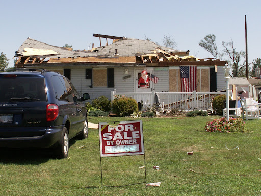
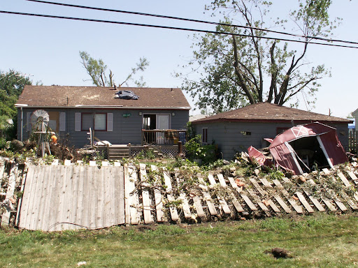
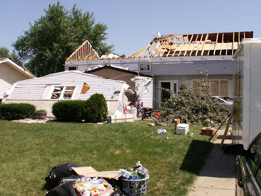
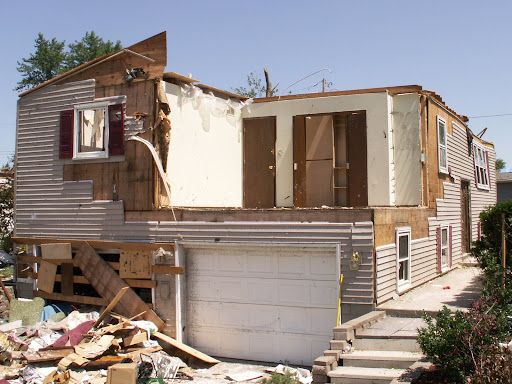
These are storm damage photos from the EF2 Tornado that hit Griffith, Indiana on August 4, 2008. Photo Credit: The Robin Storm /AM 1420 WIMS Severe Storm Intercept Team.

MARITIME NOTE
Independent Dutch towage and salvage company Multraship and Belgian salvage operator URS Salvage & Maritime Contracting have refloated an Italian-flag chemical carrier which grounded off the Dutch coast on July 31.
The 5,045GT ‘Rubino’ grounded off a popular tourist beach at Zoutelande just after high tide. Bathers and swimmers were ordered out of the water to safety. The salvors, operating under an LOF agreement and working in close co-operation with the local authorities, mobilized an expert salvage team and three tugs, with others standing by, to refloat the vessel, which was thereafter towed to the Scheldepoort shipyard for inspection. No severe damage was found, and the vessel has been redelivered to its owners.
Updated: Search For Missing Teen Delayed Until Monday
Weather Conditions Too Dangerous For Divers
RS


![[Valid RSS]](valid-rss.png "Validate my RSS feed")