 New approach to warning siren activation unveiled
Oakland County officials have announced and implemented a new countywide severe weather warning system that involves activating existing and future tornado sirens before a tornado is spotted in the field or indicated on radar.
County Executive L. Brooks Patterson and Emergency Response and Preparedness Director Mike Sturm detailed the sweeping change in the county's outdoor warning siren system on Wednesday, Sept. 10. Under the new approach, sirens will be activated when winds of 70 mph have been recorded in or around the immediate county borders.
"In the past, the sirens have only been activated when a tornado has been sighted or indicated on radar," Patterson said. "Henceforth, the outdoor warning system will be activated when severe thunderstorms with damaging winds at or near 70 mph are in Oakland County or within a 10-mile buffer around the county."
If a 70 mph standard had been in place, Oakland County would have activated warning sirens an additional half a dozen times since January 2006, rather than just the three times the sirens were sounded during the same period of time based on National Weather Service standards.
Sturm said it was felt that any severe weather condition that could result in widespread or severe damage, injury or loss of life or property should warrant activation of the outdoor warning system. He added that winds of 65 mph or more could do as much damage as a low-grade tornado.
The previous outdoor warning system began in 1977. There are 228 sirens in place across the county, with two more about to be installed. The total cost of siren installation is around $20,000, according to county officials.
Last October, three new tornado sirens were slated to be installed in three lakes area communities. Commerce, Highland, and Waterford townships netted the warning devices in the last year after the county received a $68,000 Urban Area Security Initiative Grant — federal money passed to the state and then passed on to the county — that made the purchase and installation of the sirens possible.
WEATHER NOTE
Response agencies scramble to keep up with storm season
Although SBA has been part of the responses to many of this year’s natural disasters, employee fatigue has not yet been an issue, said Sandy Baruah, acting SBA administrator.
World is Now Committed to a Significant Warming
Even if greenhouse gas concentrations would remain constant at 2005 levels for the next century, which is a highly optimistic scenario, according to a group of researchers from the Scripps Institution of Oceanography, the earth will still warm about 4.3 degrees F (2.4 C) above pre-industrial levels.
According to Climate Sciences professor V. Ramanathan and co-author Yan Feng, 90% of this warming will most likely be experienced in the 21st century.
Below are exerpts from the ScienceDaily article...............
"This paper demonstrates the major challenges society will have to face in dealing with a problem that now seems unavoidable," said Ramanathan. "We hope that governments will not be forced to consider trade-offs between air pollution abatement and mitigation of greenhouse gas emissions."
The authors point out that the real problem is not the reduction of air pollution, but it is the lack of comparable reductions in emissions of CO2 and other greenhouse gases to offset the reductions in the surface cooling effect of fog. The paper also offers potential solutions.
There's a special room at the Marshall Space Flight Center. Researchers call it the "Anechoic Chamber" and they love to test their high-tech instruments there. Normal people think it's just plain spooky.
"In here, no one can hear you scream," says engineer Mark James as he opens the door on the surreal:
The door creaks shut behind James and suddenly it's like someone hit the mute button. Dead silence. Pyramids on the wall seem to be closing in. The urge to scream ... hard to resist.
James just gets on with the job. He's lead engineer on a research team using this cavernous facility to test a prototype hurricane sensor called HIRAD. Short for Hurricane Imaging Radiometer, HIRAD is designed to scan large areas of ocean for microwave signals that portend storm strength and dynamics. By collecting and transmitting these data to forecasters, HIRAD could reduce property damage and even save lives.
The Anechoic Chamber is the perfect place to check HIRAD's antenna.
Weird shapes lining the chamber's walls are made of a radio-frequency damping material arranged in a pattern akin to soundproof rooms. The shapes minimize microwave reflections and eliminate electromagnetic interference.
"The electromagnetic quiet allows us to test and fully characterize the HIRAD antenna," explains James. "Lack of sound is just a weird bonus."
A microwave source at one end of the chamber sends signals to the HIRAD antenna at the other end. In this way, engineers can explore the antenna's beam pattern to check that it meets the requirements of the mission ahead.
Using microwaves, "HIRAD will be able to map out wind speeds on the ocean's surface--in particular the hurricane strength within the eye wall and elsewhere," says Tim Miller, HIRAD principal investigator at the National Space Science and Technology Center in Huntsville, Alabama. "We can also determine how heavy the rain is and the temperature of the ocean surface, more indicators of hurricane characteristics."
Because of its design, HIRAD can make observations over a wider swath of area than instruments currently used by NOAA. And by using electronic rather than mechanical means to scan and create a two-dimensional image of the storm's dynamics, HIRAD can operate on less power than current wind measuring instruments. It's also smaller, lighter, and relatively inexpensive to build.
"HIRAD's observations will not only give weather officials more and better real-time information on storm strength, but it will also help them determine how the storm will develop and where it will go," says Miller. "All of this adds up to more advanced warnings to the public."
How is HIRAD doing so far in the "bat cave" testing?
"We're still reviewing our test data, but so far HIRAD is passing with flying colors," says Robbie Hood of the MSFC, former principle investigator for the project and still intimately involved in its development.
The next step, she says, "is to build the real thing. This is just a test unit – a laboratory prototype. Ultimately, HIRAD will be more compact and lighter weight than the unit we're testing now."
The team hopes to have HIRAD ready to fly checkout tests onboard an aircraft by fall 2009, and ready for its first hurricane experiment in 2010. HIRAD will have to compete with other candidate instruments for the hurricane experiment.
The whole team feels confident that their instrument is going to succeed. "We've got top-notch personnel working long hours to make it happen," says Miller. "We all know that HIRAD is a valuable instrument, and we want to place it in the hands of weather officials so it can do its work -- saving lives."
The trick, says James with a smile, "is not getting locked in the bat cave."
What?
MARITIME NOTEShip with 10 crew sinks off Black Sea coast
SOFIA (Reuters) - A North Korean-registered cargo ship with 10 Ukrainian and Russian crew on board sank in rough waters in the Black Sea early on Saturday, Bulgarian authorities said.
Rescuers have so far failed to find any survivors as stormy conditions hampered rescue operations, said Nikolay Apostolov head of Bulgaria's Maritime Administration Agency. Rescue workers have also not found any bodies.
Efforts to save the crew, which consisted of nine Ukrainian and one Russian seamen, will be halted for the night because of the bad weather, he said.
The Tolstoy, which carried 2,500 tonnes of metal scarp and was sailing from Russia to Turkey, sank at about 4 a.m. (0100 GMT) some 12 miles off Cape Emine on Bulgaria's Black Sea coast, officials said. It issued no SOS call, they said.
"We received the exact crew list from the authorities in Rostov (Russia). It shows the ship had 10 not 12 crew, which was the preliminary information," Apostolov said.
He said the vessel was owned by an Ukrainian company and sailed under the North Korean flag.
Nine dead after Indonesian ferry catches fire, sinks
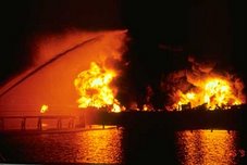
AP, JAKARTA Rescuers were searching yesterday for a missing two-year-old boy after a packed ferry caught fire and sank in eastern Indonesia, killing at least nine people, an official said. The wooden boat, the Usaha Baru, was traveling between two coastal villages in Maluku province carrying 77 passengers and crew when a fire broke out in the engine, local search and rescue agency head Eddy Paays said.Most of the passengers were Muslims traveling home to celebrate Id al-Fitr, marking the end of Ramadhan, Paays said.
Panicked passengers started jumping into the sea after the fire broke out in the engine as the boat traveled on Friday between two coastal villages in the Maluku islands, he said, adding that fisherman helped pluck many from the sea.
Rescuers continued to search for a missing toddler near the fishing village of Salahutu, he said.
At least nine people were killed in the accident and 35 others were being treated at a hospital for burn injuries, Paays said.
Ferries and passenger boats are a major form of transportation in Indonesia.
Maritime Expert Witness On Reconstruciton of Collision
Both Robert LaPointe and Terry Raye Trott apparently violated boating safety rules prior to a fatal boat crash on Long Lake, Maine, last summer, witnesses for the state testified at LaPointe's manslaughter trial Tuesday. Milford Daily News writes:
LaPointe, 39, of Medway, Mass., was going too fast at night and did not exercise care to avoid a collision when he came up on Trott's boat from behind, said Maine Warden Kevin Anderson and boat reconstruction expert William Chilcott.Trott was in violation because his rear "all-around" light was not working, and he may not have had a sounding device on his motorboat, they said.But both witnesses agreed that under federal navigation rules, LaPointe was at fault for the Aug. 11, 2007, crash. His obligation as the boat coming up from behind superseded the obligation Trott had to maintain proper lighting, they said.
"Mr. LaPointe was driving too fast at night," said Anderson, who conducted a reconstruction of the collision using the salvaged boats. "He wasn't able to avoid the collision. He ran over a boat." Boaters on Maine's lakes are required to obey the navigation rules maintained by the U.S. Coast Guard, and any other state laws or local ordinances specific to each body of water.
Anderson said boaters must travel at speeds low enough to avoid a collision with another boat, a log, a loose dock, a swimmer or any other hazard that might present itself. Anderson estimated LaPointe was going between 40 and 50 mph at the time of the crash, and Trott was going between 10 and 20 mph.
RS














![Validate my RSS feed [Valid RSS]](valid-rss.png)