 Sea alarms set
The final two buoys for a tsunami alert network are deployed
By Gary T. Kubota
WAILUKU » The final two tsunami detection buoys for the Pacific warning network were deployed this week, completing a system of sensors begun after the 2004 Indian Ocean disaster that killed hundreds of thousands of people.
Scientists say the new system will show whether an earthquake has generated a deep-ocean wave, reducing the chances of an unnecessary evacuation in Hawaii and increasing detection coverage in places such as the western Pacific and South America.
"It means that basically our uncertainties about tsunamis from tricky places have pretty much been removed," said Gerard Fryer, a geophysicist for the Pacific Tsunami Warning Center in Ewa Beach. "Right now, as far as Hawaii is concerned, we no longer have any blind spots, and let me tell you it's a wonderful feeling."
The final two buoys were deployed off the Solomon Islands, about 111 miles northeast of Australia. The network has 39 stations in the Pacific, Atlantic, Caribbean and Gulf of Mexico.
Fryer said that before 2004 there were six tsunami detection buoys, four of them in the Pacific and two not working.
He said scientists continue to monitor the magnitude of earthquakes and potential tsunamis through a network of seismometers.

Before the development of buoy technology, scientists measured wave changes through tidal gauges along coastlines.
Buoys that record wave pressure at the bottom of the ocean have enabled scientists to be more accurate in their predictions, Fryer said. Unlike surface waves generated by wind, tsunamis reach all the way to the bottom of the ocean.
The latest deep-ocean buoys, which are more reliable and cost about half as much as ones made several years ago, are able to receive wave information through low-energy sound from seabed sensors. Information is transmitted from the buoy to a constellation of earth-circling satellites.
While the northern Pacific Rim is known for frequent earthquakes, South America was the source of a tsunami in 1960 that killed 61 people in Hilo.
The magnitude of the earthquake in Chile was so large it went off the scientific measuring scale at the time and was thought initially to be magnitude 8.5, Fryer said.
Fryer said scientists took 10 years to determine that the earthquake in Chile was a 9.5.
"It was far bigger than anybody understood," he said.
Fryer said to make matters worse, an earthquake of 8.4 had generated waves of a few inches the day before the tragedy, so people "thought it was no big deal."
"We have much better instruments now," he said. "We understand the process much better."
The U.S. Tsunami Warning System is operated by the National Oceanic and Atmospheric Administration, which also oversees the Pacific Tsunami Warning Center. The agency, part of the Department of Commerce, is also working with 70 countries and the European Commission to develop an integrated global monitoring network.FROM HOLLAND AND KNIGHT
NOAA – US tsunami warning system completed The National Oceanic and Atmospheric Administration (NOAA) issued a news release stating that, with the recent deployment of two tsunami detection buoys in the South Pacific, the US tsunami warning system has been completed. (3/10/08).
WEATHER NOTES
Ice "Bergs" on Lake Michigan
The relatively warmer temperatures and sunshine of the last several days have caused areas of ice that had been affixed to the western shore of Lake Michigan off the Racine and Kenosha areas to break away from the shore. The blustery west winds on Tuesday have carried these floating ice "bergs" several miles away from shore.
Here is a high resolution MODIS visible satellite image from 102 pm CDT from March 10th.

It shows the ice remaining along the shore from Milwaukee south to Racine, Kenosha and the Illinois State Line.
What a difference a day makes! Here is a high resolution satellite image from Tuesday taken at 144 pm CDT.

The warmer temperatures, sunshine and brisk west winds have caused the ice to break away from shore and float several miles away from shore. The above freezing temperatures expected the next several days should cause these floating ice "bergs" to shrink and disappear.
Marc Kavinsky - Senior Forecaster/Meteorologist
Published 3/12/2008
By EMILY BEHLMANN
ebehlmann@gctelegram.com
Coming off of what the National Weather Service calls a record-breaking year for tornadoes in Kansas -- a total of 137 occurred in 2007, killing 14 people and injuring 82 -- several agencies are working to educate Kansans this week about severe weather preparedness.
The National Weather Service, the Kansas Emergency Management Association and the Department of Emergency Management have declared this week as Kansas Severe Weather Awareness Week.
Locally, efforts have included awareness and storm-spotter training sessions on Monday and a tornado siren test and statewide drill on Tuesday, according to Cathy Hernandez, Finney County Emergency Management coordinator.
The National Weather Service states that severe weather can threaten Kansans all year long, and Jamie Bielinski, a weather service meteorologist based in Dodge City, said residents need to realize that severe weather like tornadoes can strike anytime.
However, she said, the season that statistically sees the most tornadoes is approaching, generally running from April through June.
Tornadoes aren't the only severe-weather threat. In 2007, several severe thunderstorms, with hail and high winds, caused millions of dollars in damage to property and crops.
One came to Finney County on Aug. 20, with gusts killing a woman at Meadow Lake Park and causing damage at places including Holcomb High School, Sunflower Electric Power Corp., Peterbilt and Labrador Apartments.
The National Weather Service also warns Kansans that they should be prepared for weather like flooding and what a weather service guide calls "the underrated killer" -- lightning.
Hernandez said Finney County Emergency Management takes steps to ensure severe-weather readiness, like training storm spotters and maintaining relationships with ham radio operators who assist personnel in emergencies.
During severe weather, county public works employees serve as storm spotters and traditional first responders -- firefighters, police officers, sheriff's deputies and Emergency Medical Services employees -- go out in force to handle problems, she said.
To help avoid problems in the first place, Hernandez said her department is pushing public education through means like a Citizen Emergency Preparedness Guide. The guide is available in the Emergency Management office at the Law Enforcement Center, and it soon will be distributed throughout the community.
Hernandez and Carolyn Henry, director of Garden City's chapter of the American Red Cross, stress awareness and preparedness on an individual basis, and by businesses and organizations, as the best ways to avoid harm during severe weather. The first step is to realize when there is a risk of severe weather by paying attention to watches and warnings. A "watch" means that conditions are favorable for severe weather, and it should prompt people to keep abreast of the weather for the day, Bielinski said. A "warning" means the threat is imminent.
"If they hear a warning, they need to immediately take shelter," she said.
Tornado warnings are sounded with outdoor sirens, but Bielinski said it's usually hard to hear them indoors. That's why she recommends keeping up with television or radio reports, and using an All Hazards NOAA weather radio.
"A weather radio is basically like having a tornado siren in your home," she said.
When severe weather does strike, Henry said, it's essential to already have a disaster plan in place.
"If they're aware of what you need to do, they're not going to panic," she said. "They will not go through the stress of 'What should we do? Where should we go?'"
For a family, that plan should include two places to meet following disaster: one location right outside the home in case of a sudden emergency, like a fire, and one location outside the neighborhood in case the area is evacuated.
A plan also should include two out-of-town contacts reachable by each family member.
Henry also emphasized the need to keep a kit with a three-day supply of essential items, including important paperwork and some cash. Even if someone uses a Red Cross shelter, the agency won't be able to attend to all needs immediately, she said.
More information about severe weather preparedness is available at the Web sites for the National Weather Service in Dodge City at www.weather.gov/ddc and the U.S. Department of Homeland Security's Ready Campaign, www.ready.gov.
MARITIME NOTES
MAIB publishes report of FR8 VENTURE tragedy in Pentland Firth
Report into incident on tanker on 11th November 2006 which resulted in fatalities.
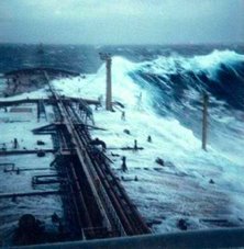
At about 1220 on 11 November 2006, while outbound from Scapa Flow and transiting the Pentland Firth, the 74,065 dwt Singaporean registered tanker, FR8 VENTURE, shipped two large waves over her bow. This resulted in the death of two able seamen (ABs) and serious injuries to an ordinary seaman (OS), all of whom were working on the forward mooring deck. The waves also caused minor damage to the ship.
RS















![Validate my RSS feed [Valid RSS]](valid-rss.png)