Showing posts with label Rouge Waves. Show all posts

Thursday, December 4, 2008

Missing radioactivity in ice cores bodes ill for part of Asia

Missing radioactivity in ice cores bodes ill for part of Asia

When Ohio State glaciologists failed to find the expected radioactive signals in the latest core they drilled from a Himalayan ice field, they knew it meant trouble for their research.

But those missing markers of radiation, remnants from atomic bomb tests a half-century ago, foretell much greater threat to the half-billion or more people living downstream of that vast mountain range.

It may mean that future water supplies could fall far short of what's needed to keep that population alive.

In a paper just published in Geophysical Research Letters, researchers from the Byrd Polar Research Center explain that levels of tritium, beta radioactivity emitters like strontium and cesium, and an isotope of chlorine are absent in all three cores taken from the Naimona'nyi glacier 19,849 feet (6,050 meters) high on the southern margin of the Tibetan Plateau.

"We've drilled 13 cores over the years from these high-mountain regions and found these signals in all but one - this one," explained Lonnie Thompson, University Distinguished Professor of Earth Sciences at Ohio State.

The absence of radioactive signals in the top portion of these cores is a critical problem for determining the age of the ice in the cores. The signals, remnants of the 1962-63 Soviet Arctic nuclear blasts and the 1952-58 nuclear tests in the South Pacific, provide well-dated benchmarks to calibrate the core time scales.

"We rely on these time markers to date the upper part of the ice cores and without them, extracting the climate history they preserve becomes more challenging," Thompson said.

"We drilled three cores through the ice to bedrock at Naimona'nyi in 2006," said Natalie Kehrwald, a doctoral student at Ohio State and lead author on the paper. "When we analyzed the top 50 feet (15 meters) of each core, we found that the beta radioactivity signal was barely above normal background levels."

Tritium, an isotope of hydrogen, and chlorine-36 were also both absent from the Naimona'nyi cores, she said. They were able, however, to find a small amount of a lead isotope, lead-210, which allowed them to date the top of the core.

"We were able to get a date of approximately 1944 A.D.," Kehrwald said, "and that, coupled with the other missing signals, means that no new ice has accumulated on the surface of the glacier since 1944," nearly a decade before the atomic tests.

While the loss of the radioactive horizons to calibrate the cores poses a challenge for Thompson's research, he worries more about the possibility that other high-altitude glaciers in the region, like Naimona'nyi, are no longer accumulating ice and the impact that could have on water resources for the people living in these regions.

"When you think about the millions of people over there who depend on the water locked in that ice, if they don't have it available in the future, that will be a serious problem," he said.

Seasonal runoff from glaciers like Naimona'nyi feeds the Indus, the Ganges and the Brahmaputra rivers in that part of the Asian subcontinent. In some places, for some months each year, those rivers are severely depleted now, the researchers said. The absence of new ice accumulating on the glaciers will only worsen that problem.

"The current models that predict river flow in the region have taken recent glacial 'retreat' into account," said Kehrwald, "but they haven't considered that some of these glaciers are actually thinning until now.

"If the thinning isn't included, then whatever strategies people adopt in their efforts to adapt to reductions in river flow simply won't work."

Thompson fears that what's happening to the Naimona'nyi glacier may be happening to many other high-altitude glaciers around the world. "I think that this has tremendous implications for future water supplies in the Andes, as well as the Himalayas, and for people living in those regions."

The absence of the radioactive signals in the 2006 Naimona'nyi core also suggests that Thompson and his colleagues have been lucky with their previous expeditions to other ice fields.

"We have to wonder -- if we were to go back to previous drill sites, some drilled in the 1980s, and retrieved new cores -- would these radioactive signals be present today?" he asked.

"My guess is that they would be missing." The researchers' recent work has shown similar thinning on glaciers in Africa, South America and in Asia in the past few years.

WEATHER NOTE

Maritimes didn't escape hurricanes this year

The Maritime provinces were hit with the remnants from various tropical storms and hurricanes this year, even though there was a less than normal number of named storms moving up the Atlantic Coast in 2008.

In some cases, the effect was no more than light rain, but in others, it was heavy rainfall fanned by gale-force winds.

It was the remnants from hurricanes Hanna and Kyle, both of which occurred in September, that brought the most severe weather conditions for New Brunswick, said Alex Sosnowski of State College. Pa., a spokesman for the AccuWeather.com Hurricane Centre.

Sosnowski said not all of the tropical storms moved into the province from the Atlantic Coast. He said some of them made their way inland, were re-energized by the Great Lakes and then, proceeded to head eastward, entering New Brunswick from the west.

The hurricane season officially runs from June 1 to the end of November, although you can sometimes get them later, such as occurred in 2005.

To be designated a name, a disturbance has to make it at least to tropical storm status. A tropical storm represents the level of severity immediately below that of a hurricane.

Sosnowski said hurricanes are rated in terms of intensity from Category 1 to Category 5 on the five-step Saffir-Simpson scale. Any of them ranking between Category 3 and 5 are considered to be major hurricanes with tremendous destructive capacity, he said.

Last year, he said there were 15 named storms, six of which reached hurricane status.

In the spring of this year, Sosnowski said the team of hurricane experts at Colorado State University predicted that there would also be 15 named storms this year, but that eight of them would graduate to hurricane status.

And they appear to have hit the nail just about on the head, said the AccuWeather.com meteorologist. To this point, he said there have been 16 named storms, eight of which became hurricanes.

Sosnowski said the last tropical storm this year was Paloma, which was a Category 4 hurricane. He said it strengthened rapidly and slammed into Cuba a few weeks ago, causing significant damage in much of that country.

The strength of high pressure over the Atlantic this year "pushed everything to the left," he said. As a result, he added, a lot of named storms ended up swinging into the Gulf of Mexico or south toward Central America.

Sosnowski anticipated there was little chance of another tropical storm developing the rest of this year.

This time of the year, he explained, there are significant wind shears that rip the tops off tropical disturbances before they can get a chance to develop into a storm or hurricane.

MARITIME NOTE

Rogue Waves: They're Real, & They're Spectacular

I recently learned I might serve this spring as a subject expert aboard a cruise ship crossing the Atlantic, as part of an "enrichment program" that provides passengers the opportunity to interact with experts in various fields. I've been identified as an individual who will address "Everything You Wanted to Know about the Weather, Sea and Sky - and Then Some!"

Sounds great. My only real concern was whether I might get sea sick, having never been on an ocean cruise. But then I began thinking about a recent presentation (ppt) on "rouge waves" given by Linwood Vincent, of the U.S. Office of Naval Research, at a meeting of the DC Chapter of the American Meteorological Society. As I thought about Vincent's nightmarish stories and pictures, I worried that sea sickness could be the least of my problems, even if the odds of encountering a rogue wave are extremely small.

Keep reading for more on these monstrous waves...

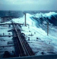
Technically, rogue waves, sometimes referred to as "freak waves," are defined as waves whose height from wave crest (highest point) to wave trough (lowest point) is more than twice the average height of the largest one-third of waves in a set of measured waves. More simply, as Vincent explained, they are essentially "big waves relative to what you expect to be there."

As described nicely by an article in the New York Times, the two most likely explanations for the occurrence of rogue waves are when smaller waves merge to form large waves, and when storm-generated waves crash into ocean currents coming from the opposite direction.

Vincent cites the example of an oil platform in the North Sea that was experiencing rough but reasonable waves of 13 to 26 feet during a storm on New Year's Day, 1995. Suddenly, seemingly out of nowhere, the platform was hit and extensively damaged by a monstrous wave that instruments measured at more than 80 feet in height (the so-called "Draupner Wave").

Want to go even bigger? In February 2000, scientific instruments onboard a British research west of Scotland measured waves up to 95 feet. More recent (but perhaps somewhat less reliable) observations have recorded wave heights up to 110 feet, about the same height as the Statue of Liberty. Just as important as height is that rogue waves are usually extremely steep. Plowing into one is like hitting a nearly vertical wall of water. If a vessel is lucky enough to survive the initial impact, then coming over the crest is like riding down the steepest incline of the world's tallest roller coaster.

And, by the way, I've never been so scared as my first ride on a roller coaster not too many years ago -- and have not been on one since.

For centuries, these enormous waves had been dismissed as myths. But scientists now recognize these giant wallops of water are far more common and destructive than once imagined. According to Vincent, freak waves are suspected of sinking at least dozens of large ships, including supertankers, while taking hundreds of lives. Freak waves are known to occur in the Great Lakes as well as the oceans. It is believed that just such a wave contributed to the sinking of the freighter SS Edmund_Fitzgerald in May 1975 on Lake Superior. All 29 hands perished in this most famous of Great Lakes disasters.

Cruise liners, at least in recent times, have been more lucky -- if you can call it that -- in their close encounters with rogue waves. In February 1995, the Queen Elizabeth II was slammed by a 95-foot-high wave in the North Atlantic. Captain Ronald Warwick described it as "a great wall of water... it looked as if we were going into the White Cliffs of Dover." But the ship survived with some passengers suffering relatively minor injuries. In April 2005 off the coast of Georgia, the Norwegian Dawn, a 965-foot ocean liner, was struck by a rogue wave estimated at 70 feet high. The wave smashed windows, sent furniture flying, injured four passengers and, not surprisingly, instilled widespread fear and panic.

And the accounts above are only a sampling of the many that have been reported. For example, see: here and here.

The only video of an actual encounter with a rogue wave I'm aware of is the amazing encounter of a 100-foot fishing boat, which was shot for the Discovery Channel's program, "The Deadliest Catch."

As for that gig on the cruise ship, I'll take the advice of my 4-year-old granddaughter: "Don't be scared, Pop-Pop. I didn't get scared when we went sledding last year down the big hill." How could I not go after that kind pep talk? And besides, running into a rogue wave is even less likely than being swept up by a tornado or hit by lightning. But I'll be sure to pack the sea-sickness pills, and probably not mention rogue waves to the passengers.

French join Canadians in Atlantic search of French crew

HALIFAX - A French naval reserve vessel has joined Canadian crews searching for survivors of a French-owned vessel that capsized and sank near the south coast of Newfoundland on Tuesday.

There were four people on board the 30-metre Cap Blanc when it went down about 16 kilometres south of Marystown, N.L. on the Burin Peninsula.

But officials said Wednesday the chance of finding survivors was growing slim. It's not known whether the crew were wearing survival suits.

Meanwhile, another rescue centre spokeswoman denied a French media report that Canadian divers had heard noises inside the vessel before it sank in about 100 metres of water at 2 p.m. local time.

Jeri Grychowski said there was no truth to the report.

The vessel was reported overdue Tuesday after departing Argentia, N.L. for the 12-hour voyage to its home port on the French islands of St-Pierre-Miquelon, off Newfoundland's south coast.

Searchers have found an empty life-raft and a life preserver, but no sign of survivors or other wreckage on the surface. The Cap Blanc was known to have carried two life-rafts.

On Wednesday, a Cormorant helicopter from Gander, N.L. continued the search, along with two coast guard vessels and the French naval ship, Fulmar.

St-Pierre is 20 kilometres off the southern tip of the Burin Peninsula, and the drama unfolding nearby is riveting many on the island of 6,500.

Finding the boat overturned in the water delivered a strong blow to the community, wrote St-Pierre magazine Mathurin on its website.

"There is an immense sadness, of a kind felt by ocean communities struck to the heart by an implacable sea," wrote author Henri Lafitte. "The wait continues until the limits of hope."


RS

Thursday, March 13, 2008

Sea alarms set

Sea alarms set

The final two buoys for a tsunami alert network are deployed


By Gary T. Kubota

WAILUKU » The final two tsunami detection buoys for the Pacific warning network were deployed this week, completing a system of sensors begun after the 2004 Indian Ocean disaster that killed hundreds of thousands of people.

Scientists say the new system will show whether an earthquake has generated a deep-ocean wave, reducing the chances of an unnecessary evacuation in Hawaii and increasing detection coverage in places such as the western Pacific and South America.

"It means that basically our uncertainties about tsunamis from tricky places have pretty much been removed," said Gerard Fryer, a geophysicist for the Pacific Tsunami Warning Center in Ewa Beach. "Right now, as far as Hawaii is concerned, we no longer have any blind spots, and let me tell you it's a wonderful feeling."

The final two buoys were deployed off the Solomon Islands, about 111 miles northeast of Australia. The network has 39 stations in the Pacific, Atlantic, Caribbean and Gulf of Mexico.

Fryer said that before 2004 there were six tsunami detection buoys, four of them in the Pacific and two not working.

He said scientists continue to monitor the magnitude of earthquakes and potential tsunamis through a network of seismometers.

art


Before the development of buoy technology, scientists measured wave changes through tidal gauges along coastlines.

Buoys that record wave pressure at the bottom of the ocean have enabled scientists to be more accurate in their predictions, Fryer said. Unlike surface waves generated by wind, tsunamis reach all the way to the bottom of the ocean.

The latest deep-ocean buoys, which are more reliable and cost about half as much as ones made several years ago, are able to receive wave information through low-energy sound from seabed sensors. Information is transmitted from the buoy to a constellation of earth-circling satellites.

While the northern Pacific Rim is known for frequent earthquakes, South America was the source of a tsunami in 1960 that killed 61 people in Hilo.

The magnitude of the earthquake in Chile was so large it went off the scientific measuring scale at the time and was thought initially to be magnitude 8.5, Fryer said.

Fryer said scientists took 10 years to determine that the earthquake in Chile was a 9.5.

"It was far bigger than anybody understood," he said.

Fryer said to make matters worse, an earthquake of 8.4 had generated waves of a few inches the day before the tragedy, so people "thought it was no big deal."

"We have much better instruments now," he said. "We understand the process much better."

The U.S. Tsunami Warning System is operated by the National Oceanic and Atmospheric Administration, which also oversees the Pacific Tsunami Warning Center. The agency, part of the Department of Commerce, is also working with 70 countries and the European Commission to develop an integrated global monitoring network.

FROM HOLLAND AND KNIGHT

NOAA – US tsunami warning system completed The National Oceanic and Atmospheric Administration (NOAA) issued a news release stating that, with the recent deployment of two tsunami detection buoys in the South Pacific, the US tsunami warning system has been completed. (3/10/08).

WEATHER NOTES

Ice "Bergs" on Lake Michigan

The relatively warmer temperatures and sunshine of the last several days have caused areas of ice that had been affixed to the western shore of Lake Michigan off the Racine and Kenosha areas to break away from the shore. The blustery west winds on Tuesday have carried these floating ice "bergs" several miles away from shore.

Here is a high resolution MODIS visible satellite image from 102 pm CDT from March 10th.

Satellite Image of Ice along Lake Michigan shore

It shows the ice remaining along the shore from Milwaukee south to Racine, Kenosha and the Illinois State Line.


What a difference a day makes! Here is a high resolution satellite image from Tuesday taken at 144 pm CDT.

Satellite Image of Ice Areas on Lake Michigan

The warmer temperatures, sunshine and brisk west winds have caused the ice to break away from shore and float several miles away from shore. The above freezing temperatures expected the next several days should cause these floating ice "bergs" to shrink and disappear.

Marc Kavinsky - Senior Forecaster/Meteorologist

Being prepared

Published 3/12/2008

By EMILY BEHLMANN

ebehlmann@gctelegram.com

Coming off of what the National Weather Service calls a record-breaking year for tornadoes in Kansas -- a total of 137 occurred in 2007, killing 14 people and injuring 82 -- several agencies are working to educate Kansans this week about severe weather preparedness.

The National Weather Service, the Kansas Emergency Management Association and the Department of Emergency Management have declared this week as Kansas Severe Weather Awareness Week.

Locally, efforts have included awareness and storm-spotter training sessions on Monday and a tornado siren test and statewide drill on Tuesday, according to Cathy Hernandez, Finney County Emergency Management coordinator.

The National Weather Service states that severe weather can threaten Kansans all year long, and Jamie Bielinski, a weather service meteorologist based in Dodge City, said residents need to realize that severe weather like tornadoes can strike anytime.

However, she said, the season that statistically sees the most tornadoes is approaching, generally running from April through June.

Tornadoes aren't the only severe-weather threat. In 2007, several severe thunderstorms, with hail and high winds, caused millions of dollars in damage to property and crops.

One came to Finney County on Aug. 20, with gusts killing a woman at Meadow Lake Park and causing damage at places including Holcomb High School, Sunflower Electric Power Corp., Peterbilt and Labrador Apartments.

The National Weather Service also warns Kansans that they should be prepared for weather like flooding and what a weather service guide calls "the underrated killer" -- lightning.

Hernandez said Finney County Emergency Management takes steps to ensure severe-weather readiness, like training storm spotters and maintaining relationships with ham radio operators who assist personnel in emergencies.

During severe weather, county public works employees serve as storm spotters and traditional first responders -- firefighters, police officers, sheriff's deputies and Emergency Medical Services employees -- go out in force to handle problems, she said.

To help avoid problems in the first place, Hernandez said her department is pushing public education through means like a Citizen Emergency Preparedness Guide. The guide is available in the Emergency Management office at the Law Enforcement Center, and it soon will be distributed throughout the community.

Hernandez and Carolyn Henry, director of Garden City's chapter of the American Red Cross, stress awareness and preparedness on an individual basis, and by businesses and organizations, as the best ways to avoid harm during severe weather. The first step is to realize when there is a risk of severe weather by paying attention to watches and warnings. A "watch" means that conditions are favorable for severe weather, and it should prompt people to keep abreast of the weather for the day, Bielinski said. A "warning" means the threat is imminent.

"If they hear a warning, they need to immediately take shelter," she said.

Tornado warnings are sounded with outdoor sirens, but Bielinski said it's usually hard to hear them indoors. That's why she recommends keeping up with television or radio reports, and using an All Hazards NOAA weather radio.

"A weather radio is basically like having a tornado siren in your home," she said.

When severe weather does strike, Henry said, it's essential to already have a disaster plan in place.

"If they're aware of what you need to do, they're not going to panic," she said. "They will not go through the stress of 'What should we do? Where should we go?'"

For a family, that plan should include two places to meet following disaster: one location right outside the home in case of a sudden emergency, like a fire, and one location outside the neighborhood in case the area is evacuated.

A plan also should include two out-of-town contacts reachable by each family member.

Henry also emphasized the need to keep a kit with a three-day supply of essential items, including important paperwork and some cash. Even if someone uses a Red Cross shelter, the agency won't be able to attend to all needs immediately, she said.

More information about severe weather preparedness is available at the Web sites for the National Weather Service in Dodge City at www.weather.gov/ddc and the U.S. Department of Homeland Security's Ready Campaign, www.ready.gov.

MARITIME NOTES

MAIB publishes report of FR8 VENTURE tragedy in Pentland Firth
Report into incident on tanker on 11th November 2006 which resulted in fatalities.

At about 1220 on 11 November 2006, while outbound from Scapa Flow and transiting the Pentland Firth, the 74,065 dwt Singaporean registered tanker, FR8 VENTURE, shipped two large waves over her bow. This resulted in the death of two able seamen (ABs) and serious injuries to an ordinary seaman (OS), all of whom were working on the forward mooring deck. The waves also caused minor damage to the ship.

From 10 to 11 November, FR8 VENTURE carried out a ship-to-ship transfer with another tanker, Perseverance, while at anchor in Scapa Flow, and loaded a full cargo of crude oil. The loading operations were completed at 0536, and Perseverance let go from FR8 VENTURE and left Scapa Flow. FR8 VENTURE weighed anchor at about 1054 and the two pilots disembarked near the entrance to Scapa Flow at about 1136. The wind was west to west-north-west and near gale force, with waves of about 4 to 5m high. The ship’s freeboard was about 6.6m and spray was being shipped on board. The tidal stream was flowing generally in the same direction as the wind. (report continued)


RS

Wednesday, August 29, 2007

Fourth In A Series - Waves

Introduction

The roughness of the oceans has important consequences for seafarers and coastal communities, and is linked to the global climate system through atmospheric circulation and winds. Satellite altimetry brought a global perspective on ocean wave climate (Chelton et al., 1981). With the accumulation of lengthy and carefully validated datasets from a number of satellite altimeters, it is now possible to evaluate the seasonality and inter-annual variability of wave climate globally to a resolution of the order of 100km.

Measuring Waves with Satellite Altimeters

By convention, significant wave height is defined to be four times the root-mean-square elevation of the sea surface, and is a standard statistic for the roughness of the sea surface. Satellite altimeters measure the roughness of the sea through the blurring of the leading edge of the reflected pulses by the uneven surface. Altimeter estimates of significant wave height are corrected by calibration with high-quality buoy data (Challenor and Cotton, 2001). Altimeters only measure the roughness of the sea in a small footprint (~10km diameter) immediately below the satellite. The data sampling is sparse, but sufficient to establish monthly mean significant wave heights on a 2o latitude by 2o longitude grid, or better if more than one satellite is operational. The gridded data sets are constructed from median values of individual "passes" across each grid box. Wave heights vary rapidly close to coasts. Also, the altimeter cannot measure waves if its footprint overlaps land. Therefore, the gridded altimeter datasets provide an offshore climatology only. Data along individual satellite passes can be analysed to extend analysis nearer shore, but even then the sizeable footprint of the altimeters is a limitation. Other methods are necessary to describe waves within 10km of the coastline.

Passes in the vicinity of United Kingdom

(Topex/Poseidon/Jason in Black, ERS-&2/Envisat in Red)

Global Wave Climatology

Average significant wave height can be measured monthly over the globe by satellite altimeter. Wave height varies regionally and seasonally, monthly means mostly varying between 1 metre and 5 metres. Generally, the sea is rougher at high latitudes (North and South) than in the tropics. Wave climate in the extra-tropical North Pacific and North Atlantic is especially seasonal with much rougher conditions in the northern (boreal) winter than in the summer. The Southern Ocean is roughest in the southern (austral) winter, but is very rough throughout the year. Nearer the equator, larger waves can be either swell propagating from higher latitudes, or can be the result of seasonal winds (e.g., monsoons and tropical storms). The Arabian Sea is particularly rough from June to August coinciding with the Southwest Monsoon.

The seasonal and regional wave climate can be summarised by fitting a sinusoidal function of annual period to the monthly mean significant wave heights for each grid square. At each location, the seasonality can be represented by the annual mean, the timing of the maximum wave height (phase of the sinusoid) and the range (twice the amplitude of the sinusoid).

Global Seasonality of Waves. Top: Annual Mean (metres); Middle: Annual Range (metres); Bottom: Phase (peak in months)

North Atlantic and British Isles

There is evidence that the North Atlantic Ocean grew considerably rougher between the 1960s and 1980s, during the age of the ocean weather ships, at least at a few isolated stations (Bacon and Carter, 1991). Is this natural variability or global warming? A new perspective is brought by analysis of satellite data.

The seasonality of wave climate around the British Isles is derived from monthly gridded altimeter measurements over five complete years (1993-1997). The ocean relatively rough throughout the year, while more sheltered regions, for example around south east England, are relatively calm. The seasonality varies slightly from region to region. For example, the spring tends to be slightly rougher than the autumn to the north west of the British Isles, but the reverse is generally true in the North Sea and the Southwest Approaches.

Seasonality of wave climate around the UK

The seasonal cycle is a fair representation of the average climate in the 1990s. However, there is also a great deal of variability about the mean in individual years. This is especially true during the winter months in the Atlantic and Atlantic margins, with monthly mean significant wave heights changing by up to a factor of two from one year to the next. The most obvious candidate as a source for this variability is the North Atlantic Oscillation (Hurrell, 1995), which has a widespread effect on many facets of climate, particularly in the months of December to March. We use gridded mean significant wave heights from these four calendar months in six consecutive winters, 92/93 -97/98. For each of the 24 months, "anomalies" are calculated by subtracting the mean seasonal cycle. Principal component methods are used to derive a spatial pattern of significant wave height anomalies whose time-dependent amplitudes are maximally correlated to an NAO index (Jones et al., 1997). A model for the anomalies is constructed by using the spatial pattern to calculate coefficients of a linear model relating the monthly anomaly to the monthly NAO index.

Inter-annual variability of wintertime wave climate

(above, spatial pattern of 1st eof; below, principal component (red crosses) and NAO Index (black squares)

The performance of the model is illustrated at a single location (57o-58oN, 8-10oW) on the edge of the Hebridean shelf. This location is typical of the region to the north west of the British Isles where inter-annual variability is greatest. Measured anomalies in excess of 2 metres (above or below the means of about 5 metres in each of the four calendar months) are recorded. These anomalies are well described by the relationship to the NAO. In other regions around the British Isles, the variability is lower and the model is less successful in describing this variability. However, the NAO is apparently a factor in determining wave climate throughout the area with the exception of the East Coast of England and Scotland.

Satellite altimetry provides a consistent coverage of wave climate around the British Isles. Previously, wave climatologies were constructed from measurements at a variety of sites and times (Draper, 1980 and 1991). The new climatology is based on measurements in the 1990s and reflects changes in wave climate since earlier decades (Bacon and Carter, 1991; Alcock and Rickards, 2001). Satellite data indicates that an upward trend in wave heights continued from the late 1980s into the early 1990s (Carter, 1999), but the behaviour during the 1990s was erratic. This behaviour can be explained by the NAO, which shifted towards more positive index values between the early 1960s and late 1990s before dramatically switching to its negative phase in the winter of 95/96. The relationship to the NAO is robust and can be used to hindcast the wave climate in much earlier times (Woolf et al., 2002).

Validation of NAO relationship at OWS Lima, extending back to the 1970s.

Behaviour of the NAO in recent decades (9-year running mean)

Hindcast of recent changes in wave height due to NAO.

Download papers on North Atlantic Wave Climate or UK Wave Climate from here


More on Hurricane Dean!

MASTER ENDEAVOUR driven aground by hurrican 'Dean', in Fort de France bay (Martinique - FWI), night 16-17 Aug 2007. The ship was anchored in the bay without crew, under arrest for drug smuggling.


RS

Thursday, August 16, 2007

UPDATE - Dean Upgraded to Hurricane

Hurricane Dean could threaten Gulf of Mexico

Thu Aug 16, 2007 1:36PM EDT

NEW YORK (Reuters) - Hurricane Dean, which could strengthen into a Category 4 hurricane over the next few days, will likely cross the islands of the eastern Caribbean on Friday and could threaten the Gulf of Mexico next week.

Meanwhile, Tropical Depression Erin produced heavy rains over portions of Texas as it weakened after moving inland over the south Texas coast this morning.

The energy market is watching the weather models to see if Dean will enter the Gulf of Mexico and where it could disrupt the region's oil and natural gas facilities, which account for roughly a third of U.S. oil production.

The NHC issued hurricane warnings for the Lesser Antilles islands of Dominica and St Lucia. A hurricane warning means the NHC expects a hurricane to strike the warning area within 24 hours.

At 11 a.m. EDT, the center of Dean was located about 350 miles east of Barbados and about 455 miles east of Martinique.

Dean was moving quickly toward the west at near 23 miles per hour. This would put the center of the hurricane near the Lesser Antilles, which extend south from the Virgin Islands to Trinidad and Tobago, on Friday morning.

Dean is packing maximum sustained winds near 90 mph, making it a Category 1 hurricane on the Saffir-Simpson scale.

The NHC forecast Dean will strengthen into a Category 2 hurricane (winds 96-110 mph) within 12 hours, a Category 3 hurricane (winds 111-130 mph) in about 24 hours and a Category 4 hurricane (winds of 131-155 mph) in three to four days.

In five days however, the NHC expects the storm to weaken back to Category 1 strength (winds 74-95 mph) after moving inland over the Yucatan Peninsula in Mexico.

The seven major weather models were mixed on Dean's forecast track. Two show Dean in the Gulf of Mexico in five days. Three, including the NHC model, show Dean in the Yucatan in five days. Two show Dean in Belize or Honduras in five days.

The weather models only look out about five days. Beyond that, the forecasters say it is too soon to say whether the storm, which is still in the Atlantic Ocean, will enter the Gulf of Mexico.

If the storm crosses the Yucatan and enters the southern Gulf of Mexico, it might disrupt operations in the Cantarell Complex of Mexican oil fields beneath the Bay of Campeche in addition to the U.S. facilities in the northern Gulf.

The Cantarell Complex is one of the most productive oil fields in the world, supplying about two thirds of Mexico's crude oil output.

The NHC will issue another advisory on Dean at 2 p.m.

ERIN DOWNGRADED

Erin made landfall near Lamar, Texas and weakened to a tropical depression Thursday morning.

The center of Erin was located about 55 miles north-northwest of Corpus Christi, the NHC said in an advisory released before 11 a.m.

The depression was moving northwest at near 15 mph, while its maximum sustained winds declined to 35 mph.

The NHC said it would not issue additional advisories on Erin.


UPDATE: On Tropical Storm Erin

ERIN CROSSED THE TEXAS COAST NEAR LAMAR AND IS NOW MOVING FATHER
INLAND. SATELLITE IMAGES AND RADAR DATA SHOWS THAT THE DEPRESSION
STILL HAS A LARGE AREA OF RAIN WHICH IS THE MAIN THREAT AT THIS
TIME. THE DEPRESSION IS FORECAST TO MOVE TOWARD THE NORTHWEST AT
ABOUT 13 KNOTS UNTIL DISSIPATION.

RS

Thursday, May 31, 2007

The Story of the Sailing Vessel Sean Seamour II

We see and hear of the destruction that Mother Nature can rain on homes and people shore-side. But little is blogged about what Mother Nature does to people, ships and boats ( for the record, the difference between a boat and a ship, is that a boat fits onto a ship.) where seeking cover is really very limited and in most cases non-existent. As in Hollywood's version of "The Prefect Storm". Of course most of the Perfect Storm is based on third party reports as well as NOAA/NWS and USCG reports.
Just maybe the story of the s/v Sean Seamour II compares with the story plot in the Perfect Storm.
Listed here is the log entry from the s/v Sean Seamour II Skipper. The crew was rescued by the United States Coast Guard during Sub-Tropical Storm Andrea. If you remember my posting of 12 May 2007 where the USCG was searching for the s/v Flying Colours. See Subtropical Storm Andrea .

Also running afoul of Andrea was the Hapag-Lloyd Paris Express and during the storm she lost some 21 containers as I also posted on 12 May 2007. Though not unusual for container ships to loose containers during a storm, since wave effects especially those associated with signifiant wave heights (SWH) can and do a lot of damage.

This is a copy of the USCG's Press Release of the days rescues; (Thanks Dennis!)

Portsmouth, VA

The Coast Guard rescued nine people today from three sailboats off the coast of North Carolina. A Coast Guard HH-60 Jayhawk helicopter crew based out of Air Station Elizabeth City, N.C., landed at Marine Corps Air Station Cherry Point with the latest survivors, who were plucked from their sailboat about 120 miles off shore. This was Air Station Elizabeth City's third rescue today. A rescue helicopter crew hoisted three people from the sailboat Seaker at approximately 7:30 a.m. in the vicinity of Diamond Shoals, N.C. The air crew transported the rescued to Air Station Elizabeth City where they were evaluated by medical crews and released.

In addition to the Seaker rescue, three people were rescued from a makeshift life raft about 160 nautical miles east of Cape Hatteras in 34-foot seas. They were aboard the sailboat Lou Pantai when rough seas and heavy winds forced the three sailors to abandon ship. A Coast Guard helicopter crew transported the rescued to Marine Corps Air Station Cherry Point. The sailors are suffering from hypothermia.

The story of the s/v Sean Seamour II is about not just how mother nature can spin a storm but its about the survivors and there experience. Fortunately the crew was rescued after a harrowing time at sea. To date the Flying Colours remains lost at sea.

Weather wise the log is a very interesting read and tells a tale of how mother nature can just as easily spring up at sea as she does on land. Remember Sub-Tropical Storm Andrea formed off our southern east coast not in the tropics as these storms normally do, but still had an impact on shore lines, ships and people.

One of the interesting weather phenomenon that is being explored in the case of the s/v Sean Seamour is what we in the maritime community know as the 'rogue wave" or "freak wave". These waves are relatively large and spontaneous ocean surface waves, which are a threat even to large ships.

T
hese waves are more precisely defined as waves that are more than double the significant wave height (SWH), which is itself defined as the average height (trough to crest) of the one-third highest wave valid for a 12 hour period. During the last 20 years more than 200 supertankers or ships over 200 meters (656 feet) long, have sunk beneath these waves. This is somtimes known as "submarining". Rogue waves are thought to have caused many of these incidents. A ladened vessel enters the wave never to been seen again or in some cases is sunk by shear flooding of massive volumes of water or is just broken in half by the shear stress and weight of the wave and its actions.

Most of these waves occur far out at sea. But Andrea was providing us with a very interesting wave actions along the coast. Sea States along Florida, Georgia North and South Carolina were fluxing between a Sea State of 4 to 8.
We are currently investigating the possibility that the s/v Sean Seamour II was struck by one of these rogue or freak waves. We are also investigating whether or not the Hapag-Lloyd Paris Express was also in the same general area that the s/v Sean Seamour II was sailing at eventful day and was struck by the same wave.

Anyone with any information please feel free to post here or contact me.


"ENTRY LOG

By
Jean Pierre de Lutz
The vessels particulars
s/v Sean Seamour II
Last known location n34.04 /w72.24

Cape Cod, May 12th 2007


This is the log of actions and events driven by the only-subsequently named Sub-tropical Storm Andrea, leading to the sinking of s/v Sean Seamour II and the successful rescue of its entire crew on the early morning of May 7th 2007. We departed from Green Cove Springs on the Saint Johns River in the early morning of May 2nd, 2007.

Gibraltar was our prime destination with a planned stopover in the Azores for commissioning and eventually fuel. The vessel, on its second crossing was fully prepared and some of the recent preparations done by Holland Marine and skipper with crew were as follows:
Full rig check, navigation lights, new wind sensor, sheet and line check / replacement new autopilot, stuffing box and shaft seal, house battery bank, racor fuel filtering system, bottom paint, new rudder bearing and check, new auxiliary tiller, full engine maintenance, recertification of life raft and check of GPIRB (good to November 2007), update and replacement of all security equipment (PFDs, flares, medical, etc). Although paper charts were available for all planned destinations, with increased dependence on electronic navigational aids, two computers were programmed to handle both the MaxSea navigation software (version 12.5) as well as the Iridium satphone for weather data (MaxSea Chopper and OCENS).

A full electronic systems checkout and burn trial was done during the days prior to departure.
For heavy weather and collision contingencies cutter rigged Sean Seamour II was equipped with two drogues (heavy and light), collision mat, auxiliary electric pump, as well as extensive power tools to enable repairs at sea with the 2.4kva inverter. Operational process and use of this equipment was discussed at length with the crew in anticipation. Other physical process contingencies such as lashing, closing seacocks, companionway doors, etc. were equally treated. The 7 day weather GRIBs downloaded almost daily from April 25th onwards showed no inconsistencies, with the two high and two low pressure systems fairly balanced over the western Atlantic.

Only the proximity of the two low pressure systems seemed to warrant surveillance as the May 5th GRIB would indicate with a flow increase from the N,NO from 20 to 35 knots focused towards coastal waters.
Already on a northerly course some 200 nautical miles out, I maintained our navigational plan with a N,NE heading until increased winds warranted a more easterly tack planned approximately 300 nautical miles north of Bermuda towards the Azores. Wind force increased about eight hours earlier than expected and later shifted to the NE reaching well into the 60 knots range by early afternoon, then well beyond as the winds shifted. Considering that we were confronted with a sustained weather system that was quite different from the gulf stream squall lines we had weathered previous days, by mid afternoon I decided to take appropriate protective measures.

From our last known position approximately 217 nautical miles east of Cape Hatteras I reversed course, laying my largest drogue off the starboard stern while maintaining a quarter of the storm jib on the inner roller furl. This was designed to balance the boat's natural windage due in large part to its hard dodger and center cockpit structure. By late afternoon the winds were sustained at well over 70 knots and seas were building fast. I estimate seas were well into 25 feet by dusk but after adding approximately 150 feet of drogue line the vessel handled smoothly over the next eight hours advancing with the seas at about 6 knots (SOG).

By late evening the winds were sustained above 74 kts and a crew member recorded a peak of 85.5 kts.
Growing and irregular seas were the primary concern as in the very early hours of the morning the boat was increasingly struck by intermittant waves to its port side. Crew had to be positioned against the starboard side as both were tossed violently across the boat. Water began to accumulate seemingly fed through the stern engine-room air cowls. I believe in retrospect the goosenecks were insufficient with the pitch of larger waves as they were breaking onto the stern. At approximately 02.45 hours we were violently knocked all the way down to starboard. It appears that the resulting angle and tension may have caused the drogue line to rupture (clean cut), perhaps as it rubbed against the same engine-room air-intake cowl positioned just below the cleat.

The line was attached to the port side main winch then fed through the cleat where it was covered with anti-chaffing tape and lubricant. Before abandoning ship I noticed the protected part of the line was intact and extended beyond the cleat some five inches. Its position in the cleat rather than retracted from it also supports this theory.
After the knockdown I knew there was already structural damage and that we had lost control of the vessel. I pulled the GPIRB (registered to USCG documented Sean Seamour II) but I suspect that the old EPIRB from 1996 (Registered to USCG documented Lou Pantai, but kept as the vessel was sold to an Italian national in 1998) might have been automatically launched first.

I kept this unit as a redundancy latched in its housing on the port side of the hard dodger; it may have been ejected upon the first knockdown as Coast Guard Authorities questioned relatives with this vessel name versus Sean Seamour II. Herein lies a question that needs to be answered, hopefully it will be in light of the USCG report.
The GPIRB initially functioned but the strobe stopped and the intensity of the light diminished rapidly to the extent that I do not know if the Coast Guard received that signal. At the time were worried the unit was not emitting and I reinitiated the unit twice.

The unit sent for recertification with the life raft a few weeks prior had been returned from River Services. They had responded to Holland Marine that the unit was good until this coming November, functioned appropriately, and that the battery had an extra five year life expectancy. I will await reception of the Coast Guard report to find out if one or both signals was processed as all POCs were questioned regarding Lou Pantai and not my current vessel Sean Seamour II (both vessels had been / in the case of Sean Seamour II is US Coast Guard documented).


Expecting worse to come I re-lashed and locked all openings and the companionway. At 02:53hours we were struck violently again and began a roll to 180 degrees. As the vessel appeared to stabilize in this position I unlocked the companionway roof to exit an see where the life raft was. It had disappeared from its poop deck cradle which I could directly access as the helm and pedestal had been torn away. When I emerged to the surface against the boat's starboard (in righted port position) it began its second 180 degree roll.

As it emerged the rig was almost longitudinal to the boat barely missing the stern arch. Spreaders were arrayed over cockpit and port side, mast cleanly bent at deck level, forestays apparently torn away.
I ordered the crew to start all pumps. By their own volition they also cut out 2.5 gallon water bottles to enable physical bailing while I continued to locate the liferaft. It finally appeared upside down under the rig.

As its sea anchors and canopy lines were entangled in the rig and partially torn by one of the spreaders I decided to cut them away in an effort to save time and effort. I needed the crew below and had to manage the rig entanglement alone. This done I managed to move the unit forward and use its windward position to blow it over the bow to starboard, attaching it still upside down.
Below, water was being stabilized above the knees. The new higher positioned house battery bank was not shorted by the water level but the engine bank was flooded not enabling us to start the engine and pump from the bilge instead of the seacock.

In retrospect this was not a loss as having to keep one of the companionway doors off for bailing and to route the Rule pump pipe, the water pouring in from here and the through-deck mast hole were no match for the impeller' volume. Plugging the mast passage was also not a solution as it was moving and hitting violently against the starboard head wall and was dangerous to try to cope with.
I knew the situation was desperate but it was still safer to stay aboard than to abandon ship, let alone in the dark any earlier than necessary. Estimating daylight at about 05:30 hours, we needed to hold on for at least another two hours.

As the boat shifted in the waves it became increasingly vulnerable to flooding from breaking waves. One such wave at about 05:20 added about 18 inches of water, as the bow was now barely emerged these two factors triggered my decision to abandon ship. I exited first knowing that the raft was still upside down. In addition, some of the canopy lines still needed to be cut from the rig entanglement. In the precipitation the grab bag containing Iridium phone, VHF, GPS and all our personal and ship documents was lost.
As we boarded the now upturned raft it immediately flooded with the breaking waves and once unprotected from the wind by the hull structure was prone to turn over (no sea anchors nor canopy to roll over on).

Hypothermia was already gaining upon one of my crew and myself and our efforts to right and re-enter the raft drained strength. Periods spent lying on the overturned raft exposed to the wind seemed to further weaken us."
Sean Seamour II sank a few minutes after we abandoned ship fully disappearing from view after the second wave crest. We became aware of fixed wing overflight sometime between 06:00 and 07:00 hours and estimate that the Coast Guard helicopter arrived some time around 08:30 hours. As seemingly the most affected by hypothermia and almost unconscious the crew had me lifted out first.

It was a perilous process during which Coast Guard AST2 Dazzo was himself injured (later to be hospitalized with us). The liferaft was destroyed and abandoned by AST2 Dazzo as the third crew member was extracted. He also recouped the GPIRB which remained in USCG custody.
The emotions and admiration felt by my crew and myself to the dedication of this Coast Guard team is immeasurable, all the more so when hearing them comment on the severity and risk of the extraction, perhaps the worst they had seen in ten years (dixit SAT2 Dazzo).

They claim to have measured 50 plus foot waves which from our perspective were mountains. We measured after the first knockdown and before loosing our rig winds still in excess of 72 knots.
Also to be commended are the medical teams involved, from our ambulatory transfer of custody from the rescue team to the personnel awaiting us at Cherry Point Naval Hospital.

There the personnel under Director for Administration CDR Robert S. Fry sought not only to address our physical and medical trauma, but preempted the humanitarian crisis we were facing after all this loss and anguish by bringing in the disaster relief assistance of the American Red Cross to whom we owe the clothes, shelter and food that helped us survive this ordeal."


Additional Research:
Rogue Waves and Explorations of Coastal Wave Characteristics

More to come so standby!
RS