Monday, March 31, 2008

Why don't tornadoes hit cities more often?

Why don't tornadoes hit cities more often?

Joshua Wurman, president of the Center for Severe Weather Research in Boulder, Colo., whips up a response.


The glib answer for why tornadoes don't strike urban areas that often is: Cities are small.

If you take a look at Google Maps and see what percentage of the U.S. urban and suburban areas cover, it's a pretty small fraction. The regions where you have peak tornado frequencies—from Texas up through Kansas, and even east toward Atlanta and the Southeast—are open country, so that's where most tornadoes spend the overwhelming fraction of their lifetimes.

It's very rare that one encounters a city, as happened in Atlanta last weekend. In 1999 there was a tornado that hit Oklahoma City and killed about 40 people. It was a long-track tornado that lasted about an hour—but most of its lifetime was spent over pretty open country. It crossed two subdivisions, and that's where most of the fatalities happened.

The Atlanta twister has not been characterized as a violent tornado. Tornadoes are rated using the Enhanced Fujita (EF) Scale, which scores the damage caused by a particular twister on a scale from 0 to 5. Violent tornadoes are classified as EF4 and EF5, significant ones EF2 and EF3. EF5 damage is typically quite catastrophic: Houses are not only just destroyed but destroyed down to their foundation—no walls left standing--and the tornado might cause structural damage to larger, well-engineered buildings that are designed to survive even very intense winds. The tornado that went through Atlanta, although it broke lots of windows, didn't cause major damage to any downtown buildings. I believe that tornado has been rated an EF2.

As to whether global warming will increase the number of tornadoes—making it more likely that they will encounter cities—we have no clue.

Climate change predictions are uncertain, even on a global scale. One could be confident that the global temperature is going to go up; however, the error ranges on what's going to happen locally—whether the temperature is going to go up in Atlanta, or here in Boulder—are much wider.

In the case of hurricanes, there's a reasonable, if unproved, hypothesis that the storms might get more intense if global temperature rises and the surface temperature of the earth's oceans rises—after all, in terms of the physics, warm water is key to creating a hurricane. With tornadoes, you can't even make that basic statement because the effect of an increase in local temperature on tornado frequency or tornado intensity is unclear. Brazil is pretty hot, but it doesn't have a lot tornadoes. Oklahoma and Texas are really hot in July and August, but that's not the peak of their tornado season; spring is when those states see the most tornadoes.

So it is possible that climate change could shift the tornado season to earlier in the year as spring creeps into winter. Perhaps it will move the distribution of where the stronger tornadoes occur. A warming climate does not necessarily make for more tornadoes; it could cut off tornadoes completely or could cause their incidence to double.

WEATHER NOTE

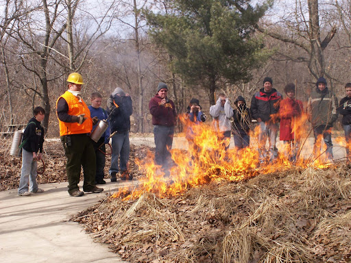
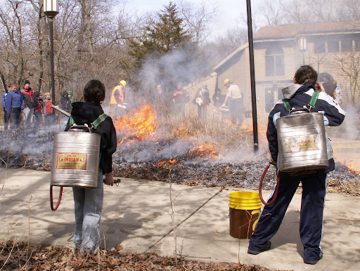
Brad Baumgardner of Indiana Dunes State Park showing the Boy Scouts how the parks department starts controlled burns.


MARITIME NOTE

Coast Guard struggles with homeland security

The Coast Guard is struggling to meet its homeland security missions in addition to its traditional missions, according to a new report from Homeland Security Inspector General Richard Skinner.

“The Coast Guard continues to experience difficulty in meeting its homeland security performance goals,” the report states.

The Coast Guard did not meet performance goals for two of its homeland security missions in fiscal 2006, the most recent year studied. The unmet goals were defense readiness, which it failed to meet for the sixth year in a row, and interdiction of illegal migrants, which it failed to meet in four of the six years surveyed, the report states.

The Coast Guard blamed the shortcomings on its aging cutter fleet, which sometimes made too few boats available for use. In the case of defense readiness, it also blamed limited time for training.

Setbacks related to the Coast Guard’s $24 billion Deepwater asset modernization program, which has encountered delays, cost increases and rejection of new assets because of structural problems, have contributed to the difficulties in maintaining a ready fleet, the inspector general said.

The Coast Guard is continuing to face difficulties in Deepwater, including problems with the Fast Response Cutters, the report states. The report also notes that the Rescue 21 program “ has been “plagued by delays, technical problems, cost escalation and a delay in full implementation, which has slipped by five years.”

Among its traditional missions, the Coast Guard failed to meet its performance measure for marine safety. It came very close to — but technically did not achieve — performance benchmarks for search and rescue, protecting marine resources, and aids to navigation. The inspector general said those were mostly technicalities, and the benchmarks themselves were imperfect.

The Coast Guard’s Deepwater and Rescue 21 programs have been among the largest contracting programs in the Homeland Security Department. The programs include not only ship construction but also acquisition of and integration electronics and computer equipment and software.

Alice Lipowicz writes for Washington Technology, an 1105 Government Information Group publication.


Slow going prevails in shipping season start
By JACK STOREY

ST. MARYS RIVER - Shipping traffic up and down the St. Marys River continued intermittently through the traditional first day of the season Tuesday.

Ships in the river overnight hove-to or tied up where they were to await daylight and the resumption of icebreaker escorts, starting with two thousand-foot self unloaders making the first downbound trips of the season.

Coast Guard operations manager Mark Gill said the 1,000-foot Indiana Harbor and Edwin H. Gott opted to lay over the nighttime hours at the Soo Locks pier wall after locking down late Tuesday. Gill explained that while the commercial ships waited, two Bay-Class tugs completed the initial opening of the often-troublesome West Neebish Channel in preparation for the two wide-bodied vessels due down early today.

He said Coast Guard ice escorts are suspended during nighttime hours because of very limited visibility and safety concerns. However, an extra hour of daylight in the evening and a bright moon overnight aided the tugs Katmai Bay and Biscayne Bay in their joint channel-clearing operation at West Neebish.

Downriver of that passage on the upbound side, a cluster of four ships waited in the ice overnight at Mud Lake before resuming their first upbound passages of the season in heavy ice conditions. Stewart J. Cort, James R. Barker, Algorail and Canadian Transfer were all expected to get underway early today after waiting out the night in the ice.

Gill expressed some worry about the West Neebish Channel, even though the wide, powerful thousand footers are ideal vessels to attempt first passages through the ice-congested channel. “We'll see how it goes,” Gill said of the often ice-choked West Neebish.

Gill said he also expects ice trouble later a short distance downriver at two other traditional choke points - the Moon Island turn, Winter Point an in Mud Lake itself.

Addressing traffic in the other direction, Gill said he expects ice trouble off Stribling Point, where the upbound channel turns sharply around the northern end of Neebish Island.

Above the Soo Locks, downbound shipping traffic seemed to be moving well enough early today. The Canadian vessel CSL Laurentian followed the two thousand footers downbound shortly after daybreak today. Despite a westerly wind that tends to pack broken ice into Whitefish Bay, two vessels - John J. Munson and Algoville - were reportedly making way downbound at various points on Whitefish Bay.

On the Straits of Mackinac, the steamer Philip R. Clarke was reportedly beset in the ice there. With St. Ignace-based Biscayne Bay otherwise occupied on the St. Marys, Gill said he hopes incoming shipping traffic on the Straits will free the stranded Clarke without pulling a tug off the lower St. Marys.

Eventually, he said he hopes to have the Bay-Class tug Mobile Bay available from Green Bay to stand in on the Straits.

The site of a ferry-stopping ice jam on Monday and early Tuesday, the Sugar Island ferry crossing cleared of ice from ship traffic and a shift of the wind late in the day on Tuesday. Ferry service back and forth to Sugar Island and Sault Ste. Marie was suspended for several hours at a time on Monday and early Tuesday.

Gill made it a point to publicly thank the US Army Corps of Engineers for assigning the Corps tug Owen Frederick to ice-clearing efforts around the Sugar Island ferry crossing. Frederick worked in tandem with the larger Katmai Bay in the tedious work of breaking up the ice jam that idled the ferry Sugar Islander II.

Gill said the loan of the Frederick was emblematic of a close working relationship between Corps and Coast Guard. The extra icebreaking tug came in very handy in the close-clearance Sugar Islander passage at Mission Point, Gill said, repeating his thanks to the Corps of Engineers.

The Coast Guard official held out some hope that additional icebreaking help will become available from farther west as the struggle with heavy river ice continues. He said at breakout, the Coast Guard can usually count on at least three Bay-Class tugs for the ice-choked lower St. Marys. However, heavy ice at Green Bay, Port Huron and at several ports on Lake Erie tied up available icebreaking vessels just as the river began to clog this year.

More a matter of ice clearing that ice breaking, the job at hand is one of influencing broken channel ice to flow downriver more easily. Or, as Gill put it, “... Breaking big chunks of ice into smaller ones.”

He suggested the going will be slow for early season shipping until several big vessels have cleared the St. Marys in both directions over coming days. He said the weather - always a major player in ice season - appears to be somewhat favorable with gradually moderating winter temperatures in the forecast.

Well aware that more ice trouble is always possible before the thaw sets in for good, Gill said, “We're not out of the woods yet.”

Ships that ply the lakes

Posted By Skip Gillham

Calumet, a former member of the Grand River Navigation fleet, rests in the outer harbour at Port Colborne. The ship was sold to International Marine Salvage in November following a minor accident at Cleveland. The laker is waiting its turn at the scrapping berth.

This vessel was one of the oldest, and many say one of the best looking, ships on the Great Lakes. It dates from 1929 and originally sailed for U.S. Steel as the Myron C. Taylor.

The 185.85-metre long steamship operated in the ore and coal trades and had a three-tiered pilothouse to provide extra accommodations for corporate guests.

U.S. Steel had the Myron C. Taylor converted to a self-unloader in 1956 and it was transferred to its Bradley Transportation division for work as a limestone carrier. With the development of taconite ore pellets, the ship experimented with an early delivery of this cargo and was a success.

A Nordberg diesel engine replaced the original triple-expansion steam plant in 1968 and this, along with its self-unloading abilities, led to the prolonged 78-year career.

While most of the ship's service was on the upper four great Lakes, Myron C. Taylor came through the Welland Canal on Dece. 1, 1983, with sand for Hamilton. It also called at Port Colborne to load stone in 1987 and brought salt to a Lake Ontario destination in 1998.

The ship joined Grand River Navigation as Calumet in 2001, and occasionally returned to the Niagara area. It is shown at Sarnia on May 17, 2005, in a photo by Marc Dease.

Age, plus extensive use in the salt trade, led to a decision to retire the vessel at the end of 2007. However, when the ship was damaged hitting a dock at Cleveland on Nov. 15, 2007, it was sold for scrap rather than make repairs for another few weeks of service. Calumet arrived at Port Colborne on Nov. 19 and, after the remaining fuel had been pumped out, the ship was towed to the scrap berth the next day.


RS

Friday, March 28, 2008

DRAMATIC INCREASES IN MERCHANT SHIP TOTAL AND PARTIAL LOSSES

DRAMATIC INCREASES IN MERCHANT SHIP TOTAL AND PARTIAL LOSSES

There has been a dramatic increase in the number of ship total and partial losses, and the upward trend looks likely to continue.

New statistics released today by the International Union of Marine Insurance (IUMI), which represents marine underwriters worldwide, indicate that the total figure for the 2006 year has jumped from an early estimate of 67 to 92 (all figures relate to ships of 500 gross tons and over), an increase of 37%.

Reported so far for 2007 are 82 total losses (compared to 67 for 2006 at the same point). If reports increase at the same level as 2006, says IUMI, by March 2009 the total will be 112. The downward trend of total losses over recent years, therefore, will be sharply arrested.

There has been an equally dramatic increase in major serious or partial losses. IUMI states: “727 serious incidents have been reported for 2006, a 6% increase since the last report, and a staggering 914 so far for 2007. This is a 270% increase in one decade, 1998-2008.”

The statistics, relating to the marine and offshore energy markets, collated and analysed by IUMI’s facts and figures, ocean hull and offshore energy committees, are based on information from a number of authoritative sources, including Lloyd’s Marine Intelligence Unit, Clarkson, Rigzone, Willis, and the International Association of Drilling Contractors.

Other highlights are:

The increase in tonnage lost in 2006 since the March 2007 report is 40% (508,141 gross tons has risen to 715,032 gt). Tonnage lost in 2007 is slightly down on 2006 at the same point – 481,741 gt.

The increase in total losses is also noticeable as a percentage of the world fleet where the percentage of tonnage lost has almost doubled from 2005 (0.06%) to 2006 (0.11%), with 2007 at this stage being 0.08%.

Weather remains the major cause of total losses but collisions have overtaken groundings as the next most common proximate cause. Of the weather losses, a total of 14 general cargo vessels over 25 years old were total losses in 2007.

The 270% increase in major serious losses over the 10-year period is equivalent to 0.64% of the fleet suffering a serious partial loss in 1998 to 1.73% in 2007. Machinery damage continues to be the major cause of serious partial losses, with a frequency of approximately 35% in the past five years.

In the offshore energy market, there is a long-term trend towards greater severity of the average loss since the early 1990s. However, the average loss frequency for 2005, 2006 and 2007 does not appear significantly higher than that seen in the early 1990s.

Analyzing the offshore losses, excluding the spate of hurricanes in 2004/5, there is a moderate trend for an increase in loss attributable to mechanical failure and design/workmanship.

Commenting on the statistics, Deirdre Littlefield, the New York-based president of IUMI, said: “These figures underline the relentless surge in marine claims that has come about due to a number of factors, not least being the shipping boom itself with ships and crews being driven harder than anyone can remember. Further, the figures dramatically demonstrate the volatility of marine risks.

“Regrettably,” she added, “this dangerous spiking of the casualty graph is happening when the worldwide premium base for marine insurers is flat and competition is rife. Underwriters are struggling to obtain realistic increases in their pricing of risks. But they can and must help themselves by showing discipline and practising responsible underwriting.

“Risk calculation, not risk taking, must be the underwriter’s primary concern.”

A new feature of this year’s statistics and analysis concerns cargo insurance. IUMI says that 2007 was another exceptional year of development in world trade. In just five years, the volume of goods moved by sea has risen by 50% and values by more than 110%.

The demand from emerging markets is still high, and also contributes to the massive increase in prices of raw materials: iron ore and scrap metals up by 200% since 2000, crude oil by 137%, coal by 130%, agricultural products by 55%.

“This creates a very positive environment for cargo insurers,” states IUMI. It adds that although undoubtedly there are uncertainties in the future, there has been no sign of a slowdown in trading activities.

In its shipping analysis, IUMI notes the continuing growth of the world tanker fleet, with 412 vessels delivered in 2007 and only 75 scrapped. However, a net growth of 337 compares with the much stronger net growth of 411 tankers in 2006.

A significant increase in the bulk carrier fleet is evident, with a net growth of 312 vessels (261 in 2006).

Also, “extraordinary growth in the container sector continued in 2007, with a net increase of 350 vessels (344 in 2006), and an increase of 2.623m. TEU capacity. Overall, the container fleet has reached 10.742m. TEU.

In shipbuilding, more than 80% of contracted gross tonnage is with South Korea, China and Japan.

Scrapping of the tanker and bulker fleets remains very low, about 0.5% of the world fleet in both sectors. Unsurprisingly, only 13 bulkers were scrapped in 2007, compared to an average of 125 per annum between 1998 and 2006. Scrap prices have reached a new high of $500 per lightweight ton.

Freight rates in the bulker market reached an all-time peak of over $40,000 a day – against $7,500 in 2002. However, tanker earnings dropped sharply in 2007, being approximately $30,000 per day, compared to nearly $40,000 in 2006; but this remains strong compared to the $20,000 in 2002. In 2007, secondhand tonnage prices in the bulker sector reached a new peak of $1,200 per dwt, comfortably exceeding the historical high for new buildings at $900 per dwt.

In its analysis of mobile offshore drilling unit statistics, IUMI says there has again been significant growth in the size of the world fleet, currently standing at 937 units. But the 49% increase since 1999 has not been reflected in the Gulf of Mexico where the fleet size has been largely static.

The surge in construction activity continues, it being estimated that 142 units are due for delivery between this year and 2010. By that year, comments IUMI, the contracted fleet will be 889 units, a 98% increase since 1999.

All the statistics and accompanying graphics can be found on the title page of IUMI’s website, www.iumi.com -ENDS-

NOTE

IUMI currently has 54 national associations as members, protecting and advancing their interests. It also provides an essential annual forum to discuss and exchange ideas, information and statistics of common interest. IUMI’s roots date back to 1874.

ISSUED BY: Denzil Stuart Associates, 67 George Row, London, SE16 4UH

Tel. +44 (0)20 7231 9963 / Fax +44 (0)20 7232 1738 / Email: ds@dsa-pr.com

Robins Note

Since 1 January 2008 there have been some 352 casualties worldwide of which some 88 were caused by heavy weather. The loss of life to date totals some 112 seafarers and passengers.

MARITIME NOTES

Jeff Charlton of 911team.org in London asked a interesting maritime question on the IAEM list-serve the other day that I thought needed to be answered.

Jeff's question?

"What if the need arises to replace a master or pilot because the ship has been affected by plague, terrorism, CBRn incident? How many have the competence or training to work in level A or B PPE (personal protection equipment)?

How many crew could assist him if a vessel was out of control? What if a ship was utilised as a terrorist vector agent and required mobility rather than destruction?"
So thanks to my shipmate at gCaptain here is the response by John Denham a former SF Bay Pilot.

First, who will be in charge. The COSCO BUSAN incident is a current example of the lack of a single responsible agent with authority to mobilize, coordinate, and direct a catastrophic event recovery operation in the San Francisco Bay area. The closest single authority to my knowledge is the Bay Area Conservation and Development Commission (BCDC) Yours truly a member of the Scientific and Technical Advisory Committee. As a state ( next level of responsible government) agency , BCDC has the civic and political sub-structure ( members from all contiguous communities) to organize, coordinate and direct what ever exists to respond, but lacks any experience. 9/11 experienced a similar problem to a lesser degree as only New York city was involved. Leadership is the critical survival element.

Second: Consider a nuclear weapons attack with CB fallout-out directed on the city of San Francisco. Without details consider San Francisco and the immediate 15 mile area is devastated. In such a scenario the leadership would probably come from out of the area. Sacramento would probably respond, and in so doing would call for federal assistance; that politically implies we can handle it but need help The federal government will probably respond with support, i.e. we will take charge and fix things as we see fit. And that may be worse than the bomb.

I have an ID card identifying me as a Department of Defense employee and shipyard pilot at the Mare Island Naval Ship Yard. I have no idea what program that was and I have no idea what I was to do; I left that job in 1981. But under the Civilian Defense organization, at one time there was a plan for identifying and organizing critical persons.

Some one (authority), will eventually make a decision that vessels must be moved, for some reason. Some to depart, some to arrive. Some just to be moved from A to B. The bay waters to my knowledge will be basically unaffected by the destruction and bad effects of man's attempt to resolve a problem with explosives. Therefore it is considered safe to move about on the water if there are no navigation restrictions e.g., bridges blocking passages .

Case 1: a heavily contaminated vessel must be moved from a pier to anchorage . The availability of a pilot is questionable as only those that live out side the bay area are probably unscathed, but the "authority" has quarantined San Francisco. No one in-out without permission.( A CD ID badge would be nice). Probably some tugs will be serviceable but crews are questionable due to blast damage, radiation and CB fall-out. If tugs are available and the decision is critical, then one tug ,with an experienced tug master and a couple SF Fireman with "bunny suits" can move the dirty ship to anchorage. It may not be a professional " no paint scratched" job but the ship is out and away from the pier. Some hero has to let go the ship's anchors. Any SF Fireman can do that (no USCG papers required) But he has to be properly clothed, unless the time exposure limit is acceptable, and instructed. Anchoring a ship is a technique, no skill required but instructing some one to do it properly is a skill. The average fireman will probably need 10 minutes of instruction to learn to lift the pawl, disengaged the wild cat and release the brake; and when the chain stops running, tighten the brake, drop the pawl and haul ass. Let the current do the rest.

Pilots are mostly needed for ship handling, docking, undocking and directing tugs. For expert, non-accident and timely ETA and ETD maneuvers they excel but if none of the professional criteria is required any one with a basic understanding of ship handling and seamanship can navigate a vessel from A to B. Local knowledge is helpful, but in an emergency one must use what is available. On December 7, 1941 a junior officer got a battleship underway to exit Pearl Harbor. He was not a qualified OOD.

An essential in bay area navigation is an understanding of the tides and currents. Any licensed deck officer should be able to determine the current and tide, many yachtsmen are more proficient than harbor pilots in that. Essentially one cannot expect perfection in emergencies, only results are needed.

Case 2. Terrorism is a case special situation. As I see it, there is no defense or procedure to deter a captured vessel proceeding from sea at full speed and ramming the south tower of the Golden Gate Bridge, or proceeding into San Francisco Bay to hit some thing. Frankly there are no worthwhile targets, except

may be making the evening news. However detonating a weapon of mass destruction is another case, and that has been presented. Piloting and navigation will have little affect.

Case 3. Any ship that is uncontrolled, unmanned and or not boardable. is a situation the USCG must resolve and as far as I know they have no afloat equipment readily available to manage that situation. With local help and time it is possible to disable the propeller; with tugs forcibly change the direction of movement and intentionally ground the vessel.(Alcatraz is handy) .If perchance a team of USCG personnel could be landed on board, say by aircraft ,VTS or a harbor pilot could communicate direction for navigation via radio to safely route the vessel to some alternate solutions e.g., grounding east of Treasure Island.

Case 4. A contaminated vessel or one with severe contagious disease is allegedly covered by government and international regulations requiring status ":pratique" be resolved before entering a port. In that case, the ship would anchor off shore in a quarantine status until the health situation was resolved. No pilot required. There have been cases where the USCG has crewed a vessel and brought it into port with the use of U.S. seaman. If, the culprit did not request entry and order a pilot he would not be boarded by the pilots and therefore be reported to the USCG. However if a renegade vessel attempts to sneak into the harbor, only the pilot boat, if on station, is available to report it to the VTS. However a USCG off shore surveillance radar may detect the rascal and attempt communication. Again the USCG has a flotilla of small cutters in near ready status to respond. A 15 knot ship will be in the bay in 45 minutes.

My experience with weapons, piloting and terrorism leads me to believe that the most probable man made scenario is a shipboard launched threat toward the harbor in Oakland for effect (less people but greater economic affect) or a strike to downtown San Francisco ( more people less affect). Essentially, there are no essential strategic target in the bay area at this time. Natural disasters such as earthquakes, hurricanes, tsunami or political rampage must be viewed as to degree of effect. Earthquakes, tsunami heading the list.

USA. MSC Napoli stern to be removed from Lyme Bay in May

Thursday, 27 March 2008

Work to remove the remaining section of MSC Napoli from Lyme Bay will begin in early May 2008. The remaining part of the stern section of the vessel remains aground in Lyme Bay with a list of 40 degrees to starboard.

Shaped explosives will be used to remove the propeller, the rudder, and to cut the propeller shaft. They will also be used to weaken the structure of the main engine to assist its removal. The aft section will then be systematically removed. The whole operation is expected to take roughly five months. SOSREP (Secretary of State's Representative for Maritime Salvage and Intervention) has made the decision to cut up the remaining section and take it away in small pieces, rather than removing it in larger pieces, following analysis of all options available. The option to cut the remaining section into smaller pieces is preferable since there could be issues with anchoring and cutting through the main engine and propeller shafting if the stern were cut up into larger pieces.

A pollution control plan will be in place throughout the entire operation. Following removal from the site, material will be transhipped to Holland for recycling. On completion a full underwater survey will be carried out to ensure that the seabed has been cleared of all recoverable debris from the MSC Napoli.

Throughout the winter, weather permitting, contractors have been conducting an inspection of the wreck, in daylight, on a fortnightly basis. When on site they have been checking for any change in status of the wreck and any evidence of pollution. They have also been recording photographs showing the status of the wreck. Inspections have been co-ordinated with periodical aerial inspections which have been carried out by MCA surveillance aircraft.

The Napoli's owners also have a response team from DRS, based in Branscombe, who have been monitoring the wreck and the Branscombe area daily. They have been patrolling and clearing any material which may have originated from MSC Napoli from all beaches in the Lyme Bay area.

Despite periods of severe weather over the last few weeks there is still no change in the status of the wreck.

Coast Guard Rescue: 4 Dead, 2 Missing Off Alaska


The Coast Guard says four crew members are dead and one missing after a Seattle-based fishing boat sank off Alaska's Dutch Harbor. The other crew members who abandoned ship were recovered safely. (March 24)

Spring is here ...we think?
Enjoy your weekend!

RS
Flag from the bridge.....
Congrad's to John Konrad of gCaptain who is a dad for the second time.....

Thursday, March 27, 2008

Preparing for disaster

Preparing for disaster

NEW YORK -- A new computer modeling program can help government, law enforcement, and first responders figure out how to react to disasters and best help people affected by catastrophes.

Planning with Large Agency-Networks against Catastrophes, or Plan-C for short, is a program developed at New York University's Center for Catastrophe Preparedness and Response. The program allows disaster relief agencies to simulate a catastrophic event like a hurricane or terrorist attack. But unlike other modeling software that runs similar simulations, this one also tries to predict how citizens will react, based on a whole slew of factors including their level of fear and how much they know about what's going on.

“The way you should approach disasters, that there are an infinite number of [factors] - the weather's good, the weather's bad, the people are all elderly, it's a festival of children or whatever it is,” said Lewis Goldfrank, NYU’s Chairman of Emergency Medicine.

Most crisis scenarios are pretty rare, but where local, state, and federal officials value this new software for helping them prepare for the most unexpected of the unexpected situations.

"And you've got to understand that the world has so many vulnerable people and so many special populations, that you've got to design your work to address all the critical issues," continued Goldfrank.

“We don't see hurricanes of category 4 in New York City, but if we had one we'd want to know the impact would be,” said Commissioner Joseph Bruno of the New York City Office of Emergency Management.

“That's really a pretty basic model - what kind of housing we have, how many people in the zones, what we can expect, how many we move out. Plan C gives us kind of a more sophisticated view of that impact,” continued Bruno.

Plan C has been in development for three years, and NYU now plans to get input about the program from local, state, and federal officials, in order to better tailor it to their particular needs.

news-leader.com

March 26, 2008
Preparing for disasters

Convoy of Hope program helps groups respond.

Linda Leicht
News-Leader

In the Springfield area alone, there have been at least six weather disasters in less than two years -- including ice storms, tornados and flooding.

Rob Clay, associate director of Convoy of Hope's U.S. Disaster Response, said Tuesday such disasters have heightened the need for preparation and response, especially on the part of the faith community.

"How can your church minister to the community in times of emergency?" Clay asked about 200 people gathered Tuesday, representing churches and other faith-based organizations from around the Ozarks.

He answered that churches -- like every organization -- must engage their members in personal preparation so they can then turn to community outreach.

Tuesday was the first gathering of HOPE (Helping Others Prepare for Emergencies) Begins Here, a new project of Convoy of Hope, a faith-based organization that responds to disasters around the world.

The program is delivered in three phases -- the first to the faith-based community, then to businesses and other organizations April 23, and then a preparedness festival for families May 3. It is meant to help organizations learn how to respond to emergencies of all types, for their members and communities.

Springfield, Convoy's home base, is the first community to host the series. Convoy plans to take it around the country.

Ice Storm

The ice storm of January 2007 became a learning opportunity for many churches in the area.

The American Red Cross turned to churches to serve as shelters for the hundreds of people who were left without heat or power, some for more than two weeks.

Debi Meeds, executive director of the Greater Ozarks Chapter of the Red Cross, said the lessons learned in those weeks have helped churches and the Red Cross recognize their interdependence.

"We have proven that when churches and the Red Cross partner together amazing things can happen," she said.

Mistakes have also been educational. With the obvious need arising, some churches opened their doors without first coordinating with the Red Cross or any other outreach agencies.

Meeds said after the first few hours, many of those churches realized they needed more help. Their calls for help put additional stress on the Red Cross, which sometimes could not provide what was needed.

As churches opened their doors and hearts to their neighbors, they didn't always realize that other churches nearby were also open, she said. In that way, resources were not being used wisely.

Another problem was that the public was not informed about some church shelters because the media was unaware of them.

The Red Cross's First Steps program allows churches and other facilities to be utilized in the best way for the community and for the church, said Chris Harmon, disaster services coordinator.

Schweitzer's Efforts

Schweitzer United Methodist Church in Springfield has been active in the disaster ministry.

Ed Hewlett, who heads up the ministry, talks about how the church was able to accomplish that.

In 2003, when Hewlett began the ministry, the church had no plans for a disaster. Since then, Schweitzer has not only served as a shelter in times of need, the church has been able to reach out beyond its doors to other communities and other churches, he said.

"You can't budget for it," he admitted.

The church's emergency response trailer, truck and about $20,000 in equipment were all donated, he said. And the work done has been accomplished by volunteers.

"You have to realize this is a ... ministry, not a program of the church," Hewlett said.

But before that ministry could be implemented, the church had to have plans in place. "If you're not prepared, you're part of the problem," he said.

Schweitzer is now a designated Red Cross shelter, housing both those affected by disasters and volunteers who have traveled here to assist. The church also has a regular outreach to churches that are serving as shelters in other communities.

Last summer, the church was the first in the area to be designated as a point of dispensation, or POD, in case of a pandemic or bioterrorist event.

In the case of a flu pandemic, the health department has arranged for several places where the public would be able to obtain anti-viral medication, such as Tamiflu or Relenza.

But staying out of public places is an important part of controlling a pandemic, said Molly Holtmann, health department pandemic health planner.

Organizations would be asked to take care of their own, she said.

Schweitzer volunteers have been trained to distribute the medication to its membership, something every church should do, she said: "We have to take care of each other," she said.

Schweitzer has also participated in the Community Emergency Response Team training through the Office of Emergency Management in Greene County.

"Churches need three or four CERT members in the congregation," said Director of Emergency Management Ryan Nichols.

The training prepares individuals how to take care of themselves and their family, check on neighbors, and then move on to help in the community.

Learning To Help

Leslie Jones and Anthony Johnson attended the HOPE Begins Here program to get credit for a sociology class at Central Bible College. They learned more than they expected.

"I didn't know it takes three to five days for the government to respond to a disaster," said Johnson, 20, who plans to be a pastor.

"I want to help out the community any way I can," added Johnson, who later asked how to get a HOPE Begins Here program in his hometown of Springfield, Ill.

Jones, 19, said her family home in Clinton was destroyed by a fire four years ago. "My church didn't really reach out much," she said.

She plans to take the lessons she learned to her home church and with her when she becomes a missionary.

Learning what needs doing and what a church can do is the next challenge for Troy Teague, pastoral care pastor at Grace Church in Rogersville.

A "team concept church," Grace already has 13 ministry teams, and with about 90-100 members who meet in a strip mall, the church is limited, he said.

"I want to develop a team for one specific area, to be a small part of something big," Teague said. "It could be anything."

The half-day program gave Teague plenty to think about and take back to his church.

"This is an eye opener," he said, "and a heart opener."

MARITIME NOTES

Coast Guard recalls Bering Sea rescue
(Published March 25, 2008)

JUNEAU, Alaska — The call came at 2:52 a.m. Sunday.

"Mayday. Mayday. This is the Alaska Ranger ... . We are flooding, taking on water in our rudder room."

Within minutes two Coast Guard helicopters and a search plane lifted off while a cutter equipped a third helicopter headed for the doomed fishing vessel from different parts of Alaska, all converging on a location 120 miles west of Dutch Harbor in the Aleutian Islands.

Even with the immediate scramble, it still would take rescuers time to reach the crew, who had abandoned ship.

Nearly 2 1/2 hours.

That left 47 crew members clinging to life in an ice-cold sea and being bandied around by 20-foot water swells. Ultimately 42 of them were rescued by the Coast Guard and the Ranger's sister ship, the Alaska Warrior.

Bodies of four of the five crew members who died, including the captain, were recovered. Alaska State Troopers say the four were in the water, not life boats, for about six hours, and they died of hypothermia. One man was lost at sea.

Coast Guard officials say it was one of the largest rescue efforts in recent memory, but not a total success. One crew member fell out of the rescue basket as it was being hoisted up to a helicopter. No one is certain, but he may have been the crewman who was lost.

A Jayhawk helicopter was the first to arrive, and what flight commander Lt. Brian McLaughlin saw stunned him.

"As we approached the scene, we saw three strobe lights and we assumed those were rafts," McLaughlin said. "The scene was very grim.

"We got a little closer and there was a fourth light, then a fifth, and a sixth and the numbers just kept growing. The ocean was flashing at us over about a mile-long stretch."

By then, the Alaska Ranger could no longer been seen. It sank, within 15 minutes, making its way 6,318 feet to the sea floor. That's deep enough to stack the Statue of Liberty and its foundation atop one another 20 times over.

What remained were a stretch of crew in survival suits - some illuminated in small pods, others alone - and a series of life rafts holding fishing crew.

Another helicopter and a search plane were slowed by head winds, so it was up to the Jayhawk to perform the initial rescues while it waited for the Coast Guard cutter, Munro, and its Dolphin helicopter to arrive.

While McLaughlin surveyed the area, Petty Officer 2nd Class O'Brien Hollow prepared to drop into the unlit waters. Waiting for daylight that was still hours away was not an option if rescuers were to save as many as possible.

Attached to a steel cable, Hollow descended into the water littered with crew members to see who needed the most immediate attention. He placed 13 survivors one-by-one into a basket-like gurney. He stayed in the water watching as each was hoisted into the aircraft.

"We were moving 30 to 50 feet sometimes with the swell," Hollow said of the time he was in the water, trying to stay in sync with the helicopter pilot. "We moved left, right, north, south, east, west.

As the 33-year-old Hollow worked, neither the Munro nor the Alaska Warrior had arrived.

But once the cutter got to within 80 miles, it launched its rescue helicopter, the Dolphin, armed with four crew members, said Munro Capt. Craig Lloyd.

Within 10 minutes after the Dolphin took off and about three hours after the fishing vessel's mayday call, the Jayhawk approached the cutter with its first group of survivors.

The Jayhawk first tried to take them to the Warrior because the vessel arrived before the Munro, but the Warrior's deck was filled with fishing gear and covered with sheets of ice.

"In the end, it would have been too dangerous to lower them on board," McLaughlin said.

So the Jayhawk flew another 50 miles to the cutter, which was not equipped to have this size aircraft land, but, unlike the Warrior, it could accommodate a passenger transfer.

One by one, survivors found themselves again in baskets. They were lowered to the ship, greeted by two crew members, then escorted to a mess hall that received a quick conversion into a medical ward.

Survivors received attention in the ad-hoc emergency room, replete with heaters, bags of intravenous fluids, special sleeping bags to fight hypothermia and warm blankets fresh out a dryer.

In the meantime, the Warrior was able to rescue crew members from life rafts, and the helicopters were able to pluck the rest from the Bering Sea. And the rescue didn't come without some amount of sacrifice on the part of the Coast Guard crew. Petty Officer Third Class Abe Heller at one point remained in the water so there would be enough room on the helicopter for the survivors and to keep close tabs on three remaining crew members still in the water.

Watching the survivors regroup after the rescue, Lloyd, the captain of the Munro, spotted one fisherman designing a new tattoo: that of an anchor featuring the words, "Ranger Survivor."

Coast Guard members say their efforts worked not just because of their rigorous training, but the quick thinking of the crew.

The captain of the Alaska ranger, Eric Peter Jacobsen, made certain his men had survival jackets before going overboard, according to second-hand reports from friends of crew members. The crew themselves were ordered not to talk to the media by the vessel's owner, the Seattle-based Fishing Company of Alaska.

The 42 survivors were ultimately returned to Dutch Harbor, where the fateful journey began for the Alaska Ranger.

The Munro brought the last group in late Monday. Only one crewman, Alex Olivares, spoke as he and others were hustled from the ship to waiting cabs.

"Glad to be alive," he said.


RS


Wednesday, March 26, 2008

Hurricanes - The World's Most Destructive Weather

Hurricanes - The World's Most Destructive Weather

Observing hurricanes is not just a dry academic exercise - what do you do if they head your way?


There is no doubt that hurricanes are right at the top of anyone's severe and extreme weather list.


With winds in excess of 175mph (280kph) and storm surges over 20ft (6m), damage can be complete and widespread.


Without adequate warning, loss of life can also be high, due to both drowning and injury.


Occurrence and Formation

Hurricanes are examples of cyclones - a term for any zone of low pressure enclosed within an area of higher pressure, in which the system rotates anticlockwise in the northern hemisphere, and clockwise in the south. Once the sustained wind speed exceeds 74mph (120kph) the system is defined as a hurricane in the Atlantic and eastern Pacific Oceans, a typhoon in the northwestern Pacific, and a tropical cyclone, severe tropical cyclone, or severe cyclonic storm in the southwestern Pacific or Indian Ocean.

An excellent source of information on hurricanes can be found at the National Hurricane Center website. In particular, check out the FAQ section.

Hurricanes occur in most parts of the tropics wherever the ocean waters can heat up to 80°F or 26.5°C but not within about 300 miles (500km) of the equator. They regularly occur in seven areas.

  1. Atlantic Basin - North Atlantic Ocean, Caribbean Sea, Gulf of Mexico

  2. Northeast Pacific Ocean - west of Mexico

  3. Northwest Pacific Ocean - from about the dateline to Asia, including the South China Sea

  4. North Indian Ocean - Bay of Bengal and Arabian Sea

  5. Southwest Indian Ocean - east of Africa

  6. Southeast Indian Ocean - west of Australia

  7. Southwest Pacific Ocean - east of Australia

Apart from warm oceans, other requirements for their formation include

  • Moist air extending well into the troposphere
  • Instability in the atmosphere, allowing thunderstorms to form
  • A pre-existing near surface disturbance with some rotational component
  • and not too much wind shear, or variation in wind speed and direction with height.

Hurricanes usually start as a tropical depression and intensify to become a tropical storm. With further growth, they evolve into a well organised, rotating system with strong sustained winds and heavy rain.

Once wind speed has reached 74mph (120kph), they've earnt the name hurricane.

Hurricane Categories

Because hurricanes vary so much in size and intensity, it has become necessary to categorize them to give some indication of the danger they pose to communities in their path. So while size, internal pressure, and wind speed are all important, other factors such as storm surge are very relevant.

The Saffir-Simpson Hurricane Scale, used in the USA and adjacent areas, is a 1-5 rating based on the hurricane's present intensity. This is used to give an estimate of the potential property damage and flooding expected along the coast from a hurricane landfall. While the hurricane is in open waters, wind speed is the most important factor.

Wind speed is a major contributor towards damage, and also controls the other major cause of destruction, storm surge. However storm surge varies a lot depending on the depth of the sea, the shape of the coast, and the position of the center of the hurricane. As a general rule, storm surge will be greatest to the left of the eye as it nears and crosses the coast, viewing the hurricane from the shoreline. Local disaster coordinators will be able to assess the type of damage likely in their areas.

It is important to keep in mind that hurricane intensities can change quickly. It is always better to be on the safe side, particularly if evacuation is necessary. On the other hand, things may not turn out as bad as they seemed. Both Hurricanes Katrina and Rita from late 2005, devastating as they were, decayed from Category 5 storms to Category 3 by the time they crossed the coast. But while wind speeds were not as severe as they might have been, storm surges generated during their most severe stages remained very high.

Much of the section on the Saffir-Simpson scale has been taken with little alteration from the NOAA page covering classification. I don't like ripping off other sources, but in this case it sppears best to include the full text here.

Category One Hurricane: Winds 74-95 mph (119-153 km/hr). Storm surge generally 4-5 ft (1.2-1.5m above normal. No real damage to building structures. Damage primarily to unanchored mobile homes, shrubbery, and trees. Some damage to poorly constructed signs. Also, some coastal road flooding and minor pier damage. Hurricane Lili of 2002 made landfall on the Louisiana coast as a Category One hurricane. Hurricane Gaston of 2004 was a Category One hurricane that made landfall along the central South Carolina coast.

Category Two Hurricane: Winds 96-110 mph (154-177 km/hr). Storm surge generally 6-8 feet (1.8-2.4m) above normal. Some roofing material, door, and window damage to buildings. Considerable damage to shrubbery and trees with some trees blown down. Considerable damage to mobile homes, poorly constructed signs, and piers. Coastal and low-lying escape routes flood 2-4 hours before arrival of the hurricane center. Small craft in unprotected anchorages break moorings. Hurricane Frances of 2004 made landfall over the southern end of Hutchinson Island, Florida as a Category Two hurricane. Hurricane Isabel of 2003 made landfall near Drum Inlet on the Outer Banks of North Carolina as a Category 2 hurricane.

Category Three Hurricane: Winds 111-130 mph (178-209 km/hr). Storm surge generally 9-12 ft (2.7-3.7m) above normal. Some structural damage to small residences and utility buildings with a minor amount of curtainwall failures. Damage to shrubbery and trees with foliage blown off trees and large trees blown down. Mobile homes and poorly constructed signs are destroyed. Low-lying escape routes are cut by rising water 3-5 hours before arrival of the center of the hurricane. Flooding near the coast destroys smaller structures with larger structures damaged by battering from floating debris. Terrain continuously lower than 5 ft above mean sea level may be flooded inland 8 miles (13 km) or more. Evacuation of low-lying residences with several blocks of the shoreline may be required. Hurricanes Jeanne and Ivan of 2004 were Category Three hurricanes when they made landfall in Florida and in Alabama, respectively.

Category Four Hurricane: Winds 131-155 mph (210-249 km/hr). Storm surge generally 13-18 ft (4-5.5m) above normal. More extensive curtainwall failures with some complete roof structure failures on small residences. Shrubs, trees, and all signs are blown down. Complete destruction of mobile homes. Extensive damage to doors and windows. Low-lying escape routes may be cut by rising water 3-5 hours before arrival of the center of the hurricane. Major damage to lower floors of structures near the shore. Terrain lower than 10 ft above sea level may be flooded requiring massive evacuation of residential areas as far inland as 6 miles (10 km). Hurricane Charley of 2004, a Category Four hurricane, made landfall in Charlotte County, Florida with winds of 150 mph. Hurricane Dennis of 2005 struck the island of Cuba as a Category Four hurricane.

Category Five Hurricane: Winds greater than 155 mph (249 km/hr). Storm surge generally greater than 18 ft (5.5m) above normal. Complete roof failure on many residences and industrial buildings. Some complete building failures with small utility buildings blown over or away. All shrubs, trees, and signs blown down. Complete destruction of mobile homes. Severe and extensive window and door damage. Low-lying escape routes are cut by rising water 3-5 hours before arrival of the center of the hurricane. Major damage to lower floors of all structures located less than 15 ft above sea level and within 500 yards of the shoreline. Massive evacuation of residential areas on low ground within 5-10 miles (8-16 km) of the shoreline may be required. Only 3 Category Five Hurricanes have made landfall in the United States since records began: The Labor Day Hurricane of 1935, Hurricane Camille (1969), and Hurricane Andrew in August, 1992. The 1935 Labor Day Hurricane struck the Florida Keys. Hurricane Camille struck the Mississippi Gulf Coast causing a 25-foot (7.6m) storm surge, which inundated Pass Christian. Hurricane Andrew of 1992 made landfall over southern Miami-Dade County, Florida causing 26.5 billion dollars in losses--the costliest hurricane on record. In addition, Hurricane Gilbert of 1988, plus Hurricanes Katrina, Rita and Wilma were all Category Five hurricanes at peak intensity.

Evacuation of residential areas near the shore is likely with Category 3 Hurricanes, and mandatory for Category 4 and 5. But if you are worried, don't wait for the official word.

Other areas affected by hurricanes, typhoons or cyclones use similar intensity scales.

Naming Hurricanes

Hurricanes and their equivalents in other parts of the world are given names for several reasons. Firstly, a simple naming system makes the warning process much more effective. Secondly there may be more than one active hurricane in an area, and individual names allows better reporting of their positions and threats.

Hurricanes Emmy and Frances
Hurricanes Emmy and Frances interacting in 1976 Source; NOAA Archives

Names are also given to tropical storms in the North American region, although not elsewhere in the world. This is sensible, as tropical storms can evolve into hurricanes, degenerate back to storms, and even reform to hurricane grade. Regardless of their classification they are a single weather event, and need to be watched until their final decay.

New names are assigned at the beginning of each hurricane season and dealt out in alphabetical order as each storm or hurricane appears. Names may be reused, but names of notable destructive hurricanes (Andrew, Camille, Gilbert, for example) are withdrawn.

The letters Q, U, X, Y, and Z are not used (not very many names start with these letters, giving an annual reserve of 21 names. In most years, thankfully, this is more than enough, but in the record year 2005 it wasn't. Plan B was to use the Greek alphabet, so Alpha, Beta, Gamma, Delta and Epsilon were used late in the season. Even Zeta got the nod for a late storm right at the end of 2005, well after the official end of the hurricane season.

OK, take a break before going on to Part 2 - Hurricane Tracking & Recording . Or, for something a bit lighter, try Part 3 - Tracking Hurricane Rita . Nothing too heavy there - just a few notes on what I was able to see using available resources (links are included on the page) as Rita exploded from Category 1 to Category 5 before calming to Category 3 before crossing the Gulf Coast on the Texas - Louisiana border.

More information on Hurricanes can be found among the Severe Weather articles, while you'll find heaps of other great resources -DVDs, videos, books, posters etc - at More Hurricane Resources

Ever wondered what it's like to stay on as a hurricane passes overhead? Check out Hurricane Safety for an account of sitting through Hurricane Wilma as it struck Southern Florida in October 2005.

MARITIME NOTES

Survival gear may have saved fishermen

The pilot involved in a dramatic sea rescue off Moreton Island says safety features on the boat of the stranded fishermen may have made the difference between life and death.

The four Brisbane men were spearfishing about five nautical miles off Cape Moreton on Monday afternoon when what they described as a freak wave swamped their boat, causing it to overturn and leaving the men stranded in turbulent water.

The men had no time to send out a distress signal and could only cling to the side of the vessel and hope help came.

It did – in the form of the Energex community rescue helicopter, which was activated by Australian Search and Rescue in Canberra about 2.30pm.

The AUSSAR satellite and aircraft flying overhead had picked up the distress signal from the vessel’s Emergency Position Indicating Radio Beacon.

Energex pilot Wayne Thompson said the vessel’s EPIRB and the other safety features the men had equipped it with may have made the difference between life and death.

“They had all the survival equipment, they had the EPIRB which is an absolute must, they had flares which they used to help guide us to them. They were quite well prepared,” he said.

“It could have been the difference between life and death for sure. They were blips in the ocean. It could have been a whole different outcome for them.”

With his crew helping Mr Thompson to position the aircraft, Dan King was winched down to the men where he helped them into the rescue strop.

The men were taken one by one to a nearby exposed reef and once all four were out of the water, they were airlifted two at a time to the Cape Moreton helipad.

One man was taken to Princess Alexandria hospital with a back injury.

“They said it was a huge sense of relief when they realised the helicopter was there for them,” Mr Thompson said.

“It was one of the more difficult rescues we have done, but it was a great result.”

Riverdance ferry will be scrapped

The owners of the Riverdance ferry have admitted the vessel will be scrapped after it is eventually removed from the Fylde coast.

Efforts are still ongoing to refloat the ferry, but Seatruck Ferries Ltd, have declared that the Riverdance will never sail again A spokesman for Seatruck said: "She has been declared a constructive loss and will not return to service.

"She suffered very significant damage during the last bout of bad weather.

"The plan is still to remove her in one piece, but she will be scrapped after that."

A meeting between the salvage team, the boat's owners and their insurance company was scheduled for last week, but that was postponed, and an announcement on the vessel's future remains more than a week away.

A spokesman for the Maritime and Coastguard Agency (MCGA) said: "Hugh Shaw, the Secretary of State's Representative for Maritime Salvage and Intervention, is currently looking at all options available, and is talking them through with the salvors and insurance company.

"We are still hopeful that the boat will be refloated in some form."

The ferry ran aground south of Cleveleys on January 31 after being hit by a freak wave during a storm.

Thousands of people have visited the area to see the stricken ferry, including over the Easter holiday.

18 FEARED DEAD IN SUNKEN TUG

Tuesday, 25 March 2008

Eighteen Ukrainian sailors are feared dead after a tug capsized and sank in Hong Kong after a collision with a cargo vessel. Salvors are working to attempt entry into the sunken ship, from which there have been no sounds or other indications of survivors amongst the crew trapped in the hull.

The Neftegaz 67 sank in 35 metres of water off Lantau Island on Saturday. Its hatches and deck are reportedly embedded in the sea floor, making rescue efforts difficult. The captain, who was among the seven crew rescued after the collision, has blamed the cargo vessel, the Yao Hai, for the incident, claiming it had not given his ship right of way.

The tug had been detained in Hong Kong in 2003 after port state control found its escape equipment and exits were deficient and that ship personnel did not know safety drills. It had not been detained since, however.

If the missing crew are confirmed dead, it would be Hong Kong’s worst maritime accident in decades.


RS

Tuesday, March 25, 2008

Puzzling 'Eye Of A Hurricane' On Venus

Thought this might be of interest. Ever wonder what weather is like on another planet?

Puzzling 'Eye Of A Hurricane' On Venus

ScienceDaily (Mar. 17, 2008) — Venus Express has constantly been observing the south pole of Venus and has found it to be surprisingly fickle. An enormous structure with a central part that looks like the eye of a hurricane, morphs and changes shape within a matter of days, leaving scientists puzzled.

The eye of the hurricane is at the centre of a 2000 km-wide vortex. It was discovered in 1974 by the Mariner 10 spacecraft. There is a similar structure on the planet’s north pole, which was observed by the Pioneer Venus mission in 1979.

Venus Express scientists have been studying the structure in the thermal infrared, the wavelength range which reveals the temperature at the cloud-tops. Seen in this wavelength, the core of the vortex appears very bright, probably indicating that a lot of atmospheric gases are moving downward in the region, which creates a depression at the cloud-tops, making the region hotter.

“Simply put, the enormous vortex is similar to what you might see in your bathtub once you have pulled out the plug” says Giuseppe Piccioni, co-Principal Investigator for the Visible and Infrared Thermal Imaging Spectrometer (VIRTIS) on Venus Express, at IASF-INAF, Rome, Italy.

In June 2006, the vortex appeared hourglass-shaped, closely matching observations in the north polar region by Pioneer Venus. Now we know that it changes its shape within a matter of days, from orbit to orbit. The image taken on 26 February 2007 shows the 'classic' dipole shape at the centre of the vortex, similar to that which has been observed previously. But an image taken a mere 24 hours earlier shows the centre of the vortex to be almost circular, indicating that the shape of this feature can change very fast. At other times, it is typically oval.

The vortex is very complex, with atmospheric gases flowing in different directions at different altitudes.

Scientists are not sure what actually creates the vortex. Colin Wilson, at the University of Oxford, says, “One explanation is that atmospheric gases heated by the Sun at the equator, rise and then move poleward. In the polar regions, they converge and sinks again. As the gases moves towards the poles, they are deflected sideways because of the planet’s rotation.”

The dynamic nature of this vortex is similar to behaviour observed in other vortices on Earth, including those observed at the centre of hurricanes.

Investigators will keep a close watch on the polar region and its variability, in order to gain a better understanding of how it works.

Adapted from materials provided by European Space Agency.Weather notes

MARITIME NOTES

White House – conserving our oceans

The White House released a Council on Environmental Quality (CEQ) Fact Sheet on conserving our oceans through stewardship, volunteerism, and education. (3/24/08).

Bering Sea – four dead and one missing when fishing vessel sinks

The US Coast Guard issued a press release stating that it was responding to a Mayday issued by a 190-foot fishing vessel in distress in the Bering Sea. A second press release stated that four crewmembers were reported to have died and one crewmember was missing, but the other 42 crewmembers have been rescued through the combined efforts of the Coast Guard and a sister-ship of the one that sank. A third press release stated that the Coast Guard is continuing to search for the missing individual. A fourth press release states that the search for the missing crewmember has been suspended. (3/24/08).

Ship owners warned over non reporting of accidents

BUSINESS EDITOR

SHIP owners and harbour contractors have been warned by a maritime specialist that they face fines of up to R60000 or three years in jail if they do not stick to accident procedures covering employees injured on duty.

The alert has been issued by Tony Edwards, of Shepstone &0x0026; Wylie‘s International Transport, following the SA Maritime Safety Authority‘s (Samsa‘s) having circulated a special notice.

It was that ship owners, masters and shore contractors must report casualties, accidents and serious injuries to them in terms of Section 259 of the Merchant Shipping Act of 1951.

Edwards said that in terms of the Act a fine of up to R5000 or imprisonment not exceeding three months could be imposed for a failure to report an accident.

“Increased penalties apply to a failure to report loss of life or serious injury, in which case the punishment may be a fine of up to R 60000 or imprisonment not exceeding three years.”

The requirement to report accidents applies to both South African-flagged and foreign- flagged ships. “Where a South African-flagged ship is involved, the accident must be reported to Samsa irrespective of where it occurred.

“An event involving a foreign-flagged ship need only be reported to Samsa if it occurred during a voyage to a South African port or within its territorial waters, or within a local port.

An accident must be reported to Samsa within 24 hours of a ship‘s arrival in a South African port. If it occurred in a South African port, it must be reported before the ship sails.


RS