 While I have been blogging about the twisters we had in Illinois and Wisconsin. We are not the only ones who got hit.
I received a plea for help from a friend of mine who works for a local chapter of the Red Cross in Columbus, Mississippi. The Chapter has been responding to the damage done by a tornado around January 8 2008
I ask everyone who visits my blog to consider sending a donation to the "Local Chapter" to help them out. Mississippi is one of the poorest States in the United States so every penny counts....
If anyone wants a copy of some of the damage pictures from this twister please drop me a line.
Hi every one ;
My Chapter is in need of donations. We had a Tornado come through two of our counties we service. So far the operation has cost about $70,000.00 this does not qualify for a national response and we must provide all funds for this operation. We service 5 counties in
all at our chapter i am asking if you can send a small check to our Chapter to help with the cost. the Chapters name and address is:
Att: Pauline Redmond
Tenn-Tom Chapter of the American Red Cross
220 5Th Street North
Columbus, MS 39703
(662)328-5710
I am sending you some pictures we fed 21,000 meals and 36,00 snacks for residences and workers in the area.there are approximately 200 homes affected by this storm and two counties in our district. Thank you for listening our small chapter is in need because we
still have fire families and military cases that will rely on our funds through out the year.
Thank you
Pauline Redmond
Disaster Logistic Coordinator
Here is the NWS Jackson report on the tornado events.
January 10th Severe Weather |
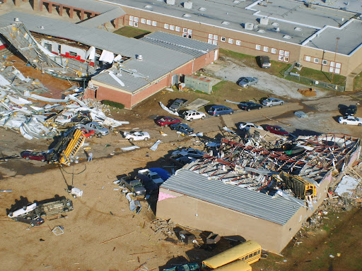
| The second week of January 2008 was quite active with respect to severe weather. Two events impacted the region in a span of 3 days which produced several tornadoes, large hail and wind damage across the area. On January 10th a vigorous storm system developed over the southern portions of the Midwest and moved northeast towards the Ohio valley. A strong cold front swept across the area during the late morning into the afternoon hours and strong to severe thunderstorms developed out ahead of it. All of the ingredients for tornadic development came into place as warm Gulf moisture pushed northward into the area out ahead of the front. The thunderstorms developed in eastern Louisiana and quickly moved across central Mississippi during the late morning and afternoon hours. As the storms progressed eastward, good instability combined with very strong wind shear for supercell development east of the Mississippi River, with the storms reaching maximum intensity along and east of the interstate 55 corridor. Teams of National Weather Service meteorologists, with assistance from state and local emergency management officials, have been working to record and analyze storm damage across the area. After surveying the tracks of several severe storms across the area, the NWS has determined that eight tornadoes were produced across the central third of Mississippi by those storms. By far, the most damage was produced by a single "supercell" thunderstorm that moved from north of Vicksburg through north central and northeast Mississippi during the late morning and early afternoon hours. This single storm produced three strong tornadoes, all of which were rated as EF3 on the Enhanced Fujita tornado damage scale. The most significant damage occurred in Caledonia in Lowndes County, where a school gymnasium was destroyed along with a number of school buses and vehicles in the area. Even though the school complex had 1900 people in it at the time of the tornado, only three minor injuries were reported at that location. A tornado warning was issued for this area by the NWS in Jackson about 39 minutes before the tornado developed to the southwest of Caledonia, and approximately 41 minutes before the damage occurred at the school in Caledonia. The longest track tornado from this event occurred in eastern Attala and Choctaw Counties. A tornado tracked for 24 miles from just west of the Ethel community in Attala County to about two miles south of Ackerman in Choctaw County. This was the tornado responsible for heavy damage to a dairy complex south of the Weir community. This is the longest track for a tornado in the central Mississippi region since the tornado outbreak of November 24, 2001. The low-level circulation associated with this first supercell intensified as it approached Goodman in Holmes County, and it was apparent that a strong tornado had formed (KDGX radar image at 11:56AM). This intense circulation remained apparent in western Attala County near Sallis (KDGX radar image at 12:05PM), and in northeast Attala County from near McCool along the Natchez Trace Parkway into Choctaw County (KDGX radar image at 12:48PM). The low-level circulation reintensified upon entering northern Lowndes County in the Columbus AFB vicinity (KGWX radar image at 2:07PM) where severe wind gusts greater than 60 mph were observed. A strong tornado touched down near Caledonia (KGWX radar image at 2:16PM) before moving east into Alabama. A second supercell that organized near the Mississippi River in southwest Mississippi before midday tracked from Claiborne County, through the northern Jackson Metropolitan Area, and finally into Noxubee county in northeast Mississippi by mid afternoon. This storm was responsible for 5 different tornado touchdowns along its path, as well as many reports of high winds and hail. National Weather Service storm survey teams rated these tornadoes as EF0s and EF1s and a majority of the relatively minor structural damage associated with them occurred just southwest of the Pearl River Resort in Neshoba County. The National Weather Service would like to thank officials from MEMA and the affected counties` Emergency Management Directors for their assistance in performing these damage surveys. *NOTE: All radar images are 0.5 degree, Storm Relative Velocity and Reflectivity. Damage ReportsPreliminary Local Storm Reports |
Here are some of the reports on these rare January 2008 tornadoes from NOAAWatch
Severe Weather in the Lower Mississippi Valley and Washington State
Fri, 11 Jan 2008 08:07:51 EST
Approximately 140 reports of severe weather were received throughout parts of Tennessee, Kentucky, Illinois, Louisiana, Georgia, Mississippi, Alabama, and Washington. The majority of these reports were wind damage reports. 21 tornadoes were reported throughout parts of Mississippi, Alabama, Louisiana, and Washington. While no fatalities have been reported, at least 18 injuries have occurred with the storms in Alabama and Mississippi. Numerous homes, farms, businesses, and other structures have also been destroyed or damaged. In Caledonia, Mississippi, a tornado struck an elementary school campus, destroying the gymnasium and heavily damaging other school structures. Three children were injured at the school. Details...
Severe Weather Reported Wednesday
Thu, 10 Jan 2008 07:43:06 EST
There were numerous reports of wind damage across parts of New York on Wednesday. A peak wind gust of 66 mph reported at Massena NY. Many other reports of 55 to 60 mph winds across St Lawrence county. Numerous roofs are reported damaged/blown off. At least one tractor trailer was reported to be tipped over by the high winds. Details...
Severe Weather Reported Tuesday
Wed, 09 Jan 2008 05:47:24 EST
Tornadoes were reported on Tuesday in Arkansas, Missouri, and Tennessee, with one death reported in Arkansas. Penny size to golf ball size hail was reported over parts of Texas, Arkansas, Mississippi, Alabama, and Tennessee. Damaging winds were reported from the Lower Mississippi Valley, across parts of the Ohio Valley, and into western New York. Details...
Deadly tornadoes across the Midwest
Tue, 08 Jan 2008 05:49:16 EST
Tornadoes were reported Arkansas, Missouri, Illinois, and Wisconsin. Two deaths were reported with the tornadoes. Damaging thunderstorm winds and large hail were reported extending from Oklahoma into Michigan and Wisconsin. Baseball size hail was reported in several locations in Missouri. Details...
MARITIME STORY - SWASH
Severe Weather Automated/Assisted Ship Handling (SWASH)
| Written by Professor Dick K.P. Yue and Dr. Yuming Liu Center for Ocean Engineering | |
|
Based on real-time sensing and forecasting of the environment and other factors, and optimum autonomous control, such vessels are able to make rapid maneuvers to negotiate or evade extreme wave conditions and/or hostile pursuers. The surface vessels allow favorable payload to fuel requirements compared to airborne (or submarine) platforms. On the other hand, the possibility of these vessels serving as platforms for drone airplanes or AUVs, and even themselves becoming airborne or submerged at a certain phase of the mission may provide a powerful paradigm shift in naval operations. The realization of the above scenario requires the development and integration of a number of capabilities all to be performed in real time: (1) sensing of the local wave field; (2) forecasting of the local wave field; (3) prediction of the vessel responses in waves; and (4) control and optimization of the vessel(s) and course. Recent developments in each of these areas, especially in sensing and forecasting of nonlinear wave fields, have substantially increased the possibility for this to be achieved. The objectives of this study are: (i) to develop a virtual simulation environment to demonstrate the feasibility of applying advanced technologies in these areas to enable substantial improvements in operational capability for single/multiple unmanned/manned surface vehicles traveling under stressing environmental conditions; (ii) to identify the key developments necessary for the realization of this capability in the near future; and (iii) (ii) to develop the technologies in the bottleneck areas, especially in wave prediction, to bring this capability to real-time applications in realistic environments. |
 We envisage a scenario in the near future that a fleet of agile unmanned surface vessels (USV), capable of cruising at high speed and following optimized courses through severe environmental conditions, can carry payloads and/or perform missions heretofore impossible or too dangerous for manned ships.
 UPDATE ON ICE PRINCE - MCA ALERT
MV ICE PRINCE

At 19:08hrs on Sunday 13 January 2008 the 6467 GRT cargo vessel MV ICE PRINCE in a position of 27 nautical miles south east of Start Point, Devon, reported that her cargo of timber had shifted resulting in a 25-35 degree list to port.
Attempts were made on Monday 14 January to put salvors on board the vessel, however this was thwarted due to adverse weather conditions
In the early hours of Tuesday 15 January the vessel started to sink in a position 26 miles SSE of Portland Bill. The vessel is now at a depth of 62 metres.
The Trinity House vessel ‘PATRICIA’ is en route and on arrival will be laying emergency buoys around the site. A full survey of the wreck site will be carried out on Thursday 17 January 2008. To ensure that the wreck does not pose a hazard to navigation a guard vessel, the Klyne Tug ‘ANGLIAN EARL’, will remain on scene until the survey has been completed.
A Temporary Exclusion Zone of 1000 metres has been implemented around the wreck site.
It has been confirmed that the vessel was carrying 5,258 tons of packaged untreated sawn timber of differing sizes; 2,516 tons on deck and 2,742 tons in the holds. An estimated 2000 tons broke free when she sank. Some of these packages have broken up into individual pieces.
A contractor has been appointed to recover any timber washed ashore. SOSREP has requested that the owners also arrange for recovery at sea of timber in estuaries and inshore waters.
Anyone finding any cargo should report it to the MCA's Receiver of Wreck (ROW) [see link below for fuller details]. Police forces along the south coast have been authorised by the ROW to act on her behalf. People failing to comply with their directions would be comitting an offence for which they may be convicted and fined up to £2500.

There have been reports of a sheen of oil on the surface of the wreck site, but this is being broken up by wave energy and natural sea movement. The salvors are currently planning how best to recover, with minimal risk to the environment, the oil and pollutants that are currently contained within tanks on the vessel.
MCA are conducting remote sensing aerial surveillance flights to ascertain the extent of the pollution. These aircraft have sensing equipment which can accurately assess the amount of oil on the sea surface both during the day and at night. In addition, the MCA have requested satellite imagery from EMSA (European Marine Safety Agency). Satellites will also be used to monitor the discharges of oil.
Please report any sighted timber to Solent Maritime Rescue Coordination Centre on
02392 559021
02392 559022
Where a vessel is wrecked ... any person (who) conceals or keeps possession of any such cargo or refuses to deliver any such cargo or article to the receiver. It is also an offence of failing to report the wreck to the Receiver.
ICE PRINCE further information/contacts/ Q&A
London Club Warns on Heavy Weather Personal Injuries

THE London P&I Club reports that recent personal injury cases which it has handled have included accidents in which the ship’s motion in heavy weather has been a causative factor.
In the latest issue of its StopLoss Bulletin, the Club notes, “The types of incidents reported have included injuries to crew members falling while working aloft, a hand injury when a heavy auxiliary engine part unexpectedly shifted while being removed for maintenance, and a chest injury suffered when a power tool slipped as a ship rolled.
“Where a risk assessment had been carried out in respect of the accidents involving deck crew, the responsible officer had been fully aware of the prevailing conditions but had not made sufficient allowance for the ship’s motion.
“Interestingly, in the cases where the task was being performed in the engine room, the entry on the risk assessment form for ‘Weather and Sea Hazard’ was in each case “not applicable”.”
The Club concludes, “While it is the case that dealing with rolling, for example, is less of an issue for someone on the bottom plates in the engine room than it is for a crew member on the monkey island, these recent cases are reminders that, when a ship rolls, the engine room moves too.”
- The London P&I Club, managed by A Bilbrough & Co, is one of the leading clubs in the International Group of P&I Clubs. It pursues a policy of selective, quality expansion and strategic investment to maintain financial strength.
Chicago Weather ALERT! Cold does not even express it!
Have warm and great weekend!
RS


![[Valid RSS]](valid-rss.png "Validate my RSS feed")