 Pilotless Craft Gather Data for Hurricane Forecasts, Climate, West Coast Flood Warnings
 + High Resolution (Credit: NOAA)
Unmanned aircraft bearing automated sensors may soon help NOAA scientists better predict a hurricane’s intensity and track, how fast Arctic summer ice will melt, and whether soggy Pacific storms will flood West Coast cities. All three efforts are part of NOAA’s Unmanned Aircraft Systems program. NOAA recently invested $3 million in federal money to explore the use of the crewless vehicles for wide-ranging research designed ultimately to help save lives and property. NOAA officials announced the funding award today at the annual meeting of the American Meteorological Society in New Orleans.
“This technology has the potential to revolutionize our monitoring of the entire Earth,” said Marty Ralph, a research meteorologist at NOAA’s Earth System Research Laboratory in Boulder, Colo., and manager of NOAA’s UAS program. “Data gathered by unmanned aircraft can help us understand how humans are affecting the planet and how we might mitigate the impacts of natural disasters resulting from severe weather and climate.”
Starting this summer, unmanned aircraft will take instruments on research flights that are too dangerous or too long for pilots and scientists. NOAA, working with university and industry partners, will lead three test projects:
- Atlantic and Gulf Hurricanes: Between August 1 and October 31, small unmanned vehicles will fly into the eye of Atlantic and Caribbean hurricanes at low altitudes too risky for crewed aircraft. The data will help experts diagnose maximum wind speeds and storm physics to improve hurricane intensity forecasts.
- Arctic Climate Change: Later this year, a larger unmanned aircraft will observe sea ice conditions and track the locations of seal populations as the climate warms. Ice and atmospheric data will help scientists figure out how clouds, soot, and other airborne particles are helping to melt Arctic ice faster than climate models project from greenhouse gases alone.
- Pacific and West Coast Storms: In spring 2009, both low- and high-altitude unmanned vehicles will fly over the Pacific to study “atmospheric rivers,” long arms of moisture from ocean storms that bring heavy rain and snow to the West Coast. The data could help forecasters warn water resource managers in time to adjust reservoir levels and avoid flooding and will shed light on weather and climate processes that affect water resources across the arid west.

+ High Resolution (Credit: NOAA)
Future missions will help monitor fisheries, track Greenland glaciers, preserve natural resources, and provide firefighters with key wildfire data. Murky plumes of volcanic emissions and urban pollution will also be targets for dirty work by unmanned vehicles.
Unmanned planes can loiter in the sky over a storm or a forest fire or continue nonstop to a distant target area, such as Antarctica. Some can reach any location on Earth in one trip. Solar-powered vehicles can fly for days at a time. Small vehicles launched from ships at sea can vastly multiply a ship’s observation area to gather rare data in remote regions.
NOAA’s cooperative institutes at Mississippi State University and the universities of Alaska, Colorado, Hawaii, and Maryland are regional partners in leading the testbeds, along with Scripps Institution of Oceanography.
The National Oceanic and Atmospheric Administration, an agency of the U.S. Commerce Department, is dedicated to enhancing economic security and national safety through the prediction and research of weather and climate-related events and information service delivery for transportation, and by providing environmental stewardship of our nation's coastal and marine resources. Through the emerging Global Earth Observation System of Systems (GEOSS), NOAA is working with its federal partners, more than 70 countries and the European Commission to develop a global monitoring network that is as integrated as the planet it observes, predicts and protects.
BE READY!Heads-up on bad weather: Be prepared
CHARLESTON — Tom Watson knows there are some people who don’t do what they’re supposed to do when the area’s threatened with bad weather.
The director of the Coles County Emergency Management Agency said he’s heard stories of people letting their curiosity get the best of them.
“I’ve had a lot of people tell me that when the sirens sound, they run outside to see what’s going on,” he said.
Watson said he wants to give people a heads-up about the upcoming severe weather season and what they really should do when bad weather threatens. The Illinois Emergency Management Agency designated this week as “Severe Weather Preparedness Week” in the state, and Watson said he doesn’t think many people are ready as they should be.
The “first priority” is to get out of the storm, he said. If a warning siren sounds for 3 minutes or longer, there’s a tornado approaching and it’s time to seek shelter, not watch the skies, he explained.
And a tornado doesn’t have to be in the immediate vicinity for conditions to be hazardous, as the debris scattered by winds of up to 200 mph from an approaching tornado is one of the storm’s most deadly aspects, he added.
“It’s very dangerous to get out in that wind,” Watson said. “It can pick up anything and make it a projectile.”
But nearly as important, he continued, is to have a plan for what to do when a storm comes, something that includes making sure that everyone in the house knows where to go.
Children need to know what to do if their parents aren’t around, he noted.
Recommended places of shelter include basements or the lowest floor of a building in an interior hallway, closet or bathroom without windows. Workplaces should have designated shelter areas, and people in vehicles should seek shelter and not try to outrun the storm, according to the National Weather Service.
A family should also be sure it has about a three-day supply of food, water, clothing, medicines and other items that people can “grab it and go with it” because they might not be readily available right after a storm, Watson added. Law enforcement and other emergency agencies will be busy after the bad weather, so it won’t be known how long before help might come, he said.
“You might have to get along on your own for several hours,” Watson said.
Tornadoes can sometimes develop suddenly and not appear on weather radar, Watson added. That’s why it’s important for people to follow weather forecasts and be ready ahead of time when a severe storm might approach, he said.
According to the National Weather Service, Coles County is 14th in Illinois for the most tornadoes the last 57 years (Douglas was 13th, and the only other one in this general area was Champaign, at 11th). Watson credited better spotting and radar technology for likely identifying some tornadoes that wouldn’t have been noticed in the past.
“I know we’ve had a lot of reports in the last five or six years,” he said.
Coles County will participate in a statewide tornado drill Tuesday, the same day as regular monthly testing of warning sirens, and a test warning will be issued for every county in the state. Watson said his agency will take the opportunity to check equipment, and the annual event is when he urges local schools to conduct severe weather drills.
Contact Dave Fopay at dfopay@jg-tc.com or 348-5733.
| Tornados em Buenos Aires - 03/03/2008 00:00 |

WATERSPOUTS ON THE STARBOARD BOW!
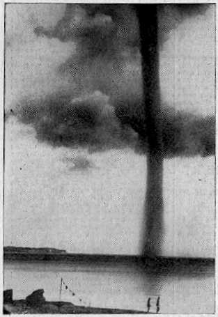
Waterspout off Rugen Island, Baltic Sea 1937
Waterspouts are (simplistically) tornadoes at sea, or on rivers and lakes. They have usually been regarded as curiosities of nature, because, unlike tornadoes, they do not often inconvenience the human race. Many waterspouts are feeble vortices which probably could not even come into existence in the turbulent air over the land, but they should not be taken lightly. Spouts have crossed onto land and become tornadoes, and some are tornadoes which have passed onto water. Even spouts far out in the ocean can be of tornadic size and power.
'Waterspout' is a rather inappropriate name, since spouts consist almost entirely of whirling cloud, with a plume of spray (the cascade) at the surface whipped up by the vortex as it touches the water. They do illustrate the difficulty of studying natural phenomena in the days before video and photography. Spouts could not be predicted, captured, or studied at leisure. Any student of waterspouts would have to rely on the accounts of people who had seen one, and they were not seen very often. They didn't even leave any physical traces unless they came ashore, which was an even rarer event. This is why the idea that spouts were literally waterspouts, streams of water pouring from the clouds (and raising spray when they hit the sea) lasted so long. An 18th Century scientist, defending the stream-of-water theory, even said, "the wonderful catalogue of nature needed not whirlwind-waterspouts to increase the number."
Waterspouts are whirlwinds, of course (something the Roman poet Lucretius knew), but it seems that powerful spouts can carry large amounts of water in the lower parts of their vortex. Some even lift water into their parent cloud, as shown by falls of salt rain after the spout has dissipated. Waterspouts are usually held responsible for the mysterious falls of fish and other aquatic animals. There are difficulties with this theory, but nobody has yet come up with a better one.
The chronology of remarkable waterspouts below is not inclusive. Many unusual spouts have had to be left out due to lack of space.
MARITIME NOTES:Riverdance ferry will not be cut up - salvors

REFLOATING the stricken Blackpool ferry will be later rather than sooner. The Riverdance does not look set to move until towards the end of the two weeks salvors described as "a window of opportunity".
Weather has played a part in hampering efforts to right the 6,000-ton vessel, which has been stuck on the beach near Anchorsholme Park since the start of February.
View our Shipwreck online special
See The Riverdance webcam
See our Riverdance picture gallery - updated daily
Salvage crews said there was a chance to move the ship sometime between now and March 13, but they say this is most likely to happen towards the end of this period.
Coastguard bosses insist the plan is still to right and then refloat the Riverdance – denying rumours that the move would be impossible and salvors would have to cut it up.
Oil Tanker Towed to Dock After SOS Call
YANBU, 6 March 2008 — An oil tanker carrying one million barrels of crude sent out a distress signal and was towed back to the King Fahd Industrial Port in Yanbu.
The ship, which reported engine failure about 200 kilometers from the port, arrived back at the port yesterday, officials told Arab News.
“KFIP’s emergency operation’s team rescued the oil tanker meandering amid the coral reefs following engine failure off the Duba coast,” Hammoud Al-Saadi, director general of the port, told Arab News yesterday.
Venture Navigation Co., Ltd. of Greece owns the 20-year-old Dominican-registered ship, according to Lloyd’s Registry. The ship was destined for the port of Aqaba, Jordan.
The distress call said the ship’s engines had broken down and was floating with the currents about 200 kilometers from Yanbu.
The rescue team found the captain of the ship steering without power as the weather was turning nasty. No injuries were reported.
“The successful operation averted a shipwreck and a major environmental disaster. The tanker was floating at an area close to virgin coral reefs. Any leakage of the ship’s load would have devastated the reefs,” Al-Saadi said.
Desalination plants in nearby Duba would have been affected by an oil spill, the port official added.
“Three powerful towboats struggled for 48 hours to bring the loaded tanker safely to the dock in Yanbu,” he said.
Oil from the Eastern Province is piped across the Kingdom for export from this northwestern port city. The western coast of Saudi Arabia is a maze of coral heads that can potentially damage and sink sea vessels. An accident involving a full oil tanker colliding with these underwater columns has a potential to cause a major environmental disaster.
RS


![[Valid RSS]](valid-rss.png "Validate my RSS feed")