Two years ago Hurricane Katrina kicked the U.S. government's ass. Now, as Hurricane Dean sweeps past Jamaica on its way to the U.S. Gulf Coast, FEMA, the Coast Guard and the other military services are poised to prove they can do better the second time around. The military response actually began days ago when the Air Force's WC-130J hurricane-hunting patrol planes deployed brand-new sensors to more accurately predict when and where Dean will hit and what kind of damage it will do, according to the service. The "Stepped-Frequency Microwave Radiometer," or "smurf,"
allows the Citizen Airmen of the Hurricane Hunters to constantly measure surface winds directly below the aircraft. The smurf can also determine rainfall rates within a storm system. This, in addition to wind speeds at flight level, provides structural detail of the storm. "The SFMR will be the biggest advance I can think of to improve hurricane intensity forecasts," said Max Mayfield, former director of the [National Hurrican Center].
The data collected by the Hurricane Hunters increase the accuracy of the NHC forecast by 30 percent, a rate which will undoubtedly increase with the use of the smurf. This data enables the NHC to more accurately predict the path of storms in order to save lives and narrow areas of evacuation, according to NHC forecasters.
U.S. Air Force Fact Sheet
STEPPED-FREQUENCY MICROWAVE RADIOMETER
PURPOSE:
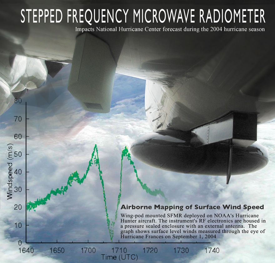
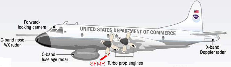
The Stepped-Frequency Microwave Radiometer is a state-of-the-art instrument designed to continuously and accurately measure the winds at the ocean's surface directly below the aircraft. The SFMR, affectionately known as "smurf", is installed on the WC-130J within a pod attached to the aircraft's wing. As the plane flies through a storm, the SFMR senses microwave radiation naturally emitted from foam created on the sea by winds at the surface. Computers then determine wind speeds based on the levels of microwave radiation detected. Currently, winds are extrapolated from the winds at the aircraft's altitude or from a dropsonde released from the aircraft, however, the SFMR directly measures the surface winds and is not confined to a single point like the dropsonde. This constant measurement of surface winds gives the National Hurricane Center a more complete picture of the storm.
The SFMR can also determine rainfall rates within a storm system. This, in addition to wind speeds at flight level, provide structural detail of the storm.
Two Hurricane Hunter aircraft will be equipped with the SFMR by the end of June with one added each month until all 10 WC-130J aircraft are outfitted with the SFMR pod, the last to be equipped in March, 2008.
SPECIFICATIONS:
Radiometer Type Hatch Tuning bandwidth 4.6 -7.2 GHz Number of channels Up to 8 Receiver Channel Bandwidth 50 MHz Antenna Type Corrugated horn Antenna Beamwidth (3 dB) 20-28 deg Polarization Linear Measurement precision 0.17 K (1second averaging) Electronics Power Requirements 28VDC, 2A Thermal Control Power Requirements 28VDC, 4A (max) Power 168 W Operating Temperature -65°C to +40°C Humidity 0 to 100% Size (L x W x H) 24" x 11" x 13" Weight 40 lbs.
WP-3D Stepped Frequency Microwave Radiometer (SFMR)
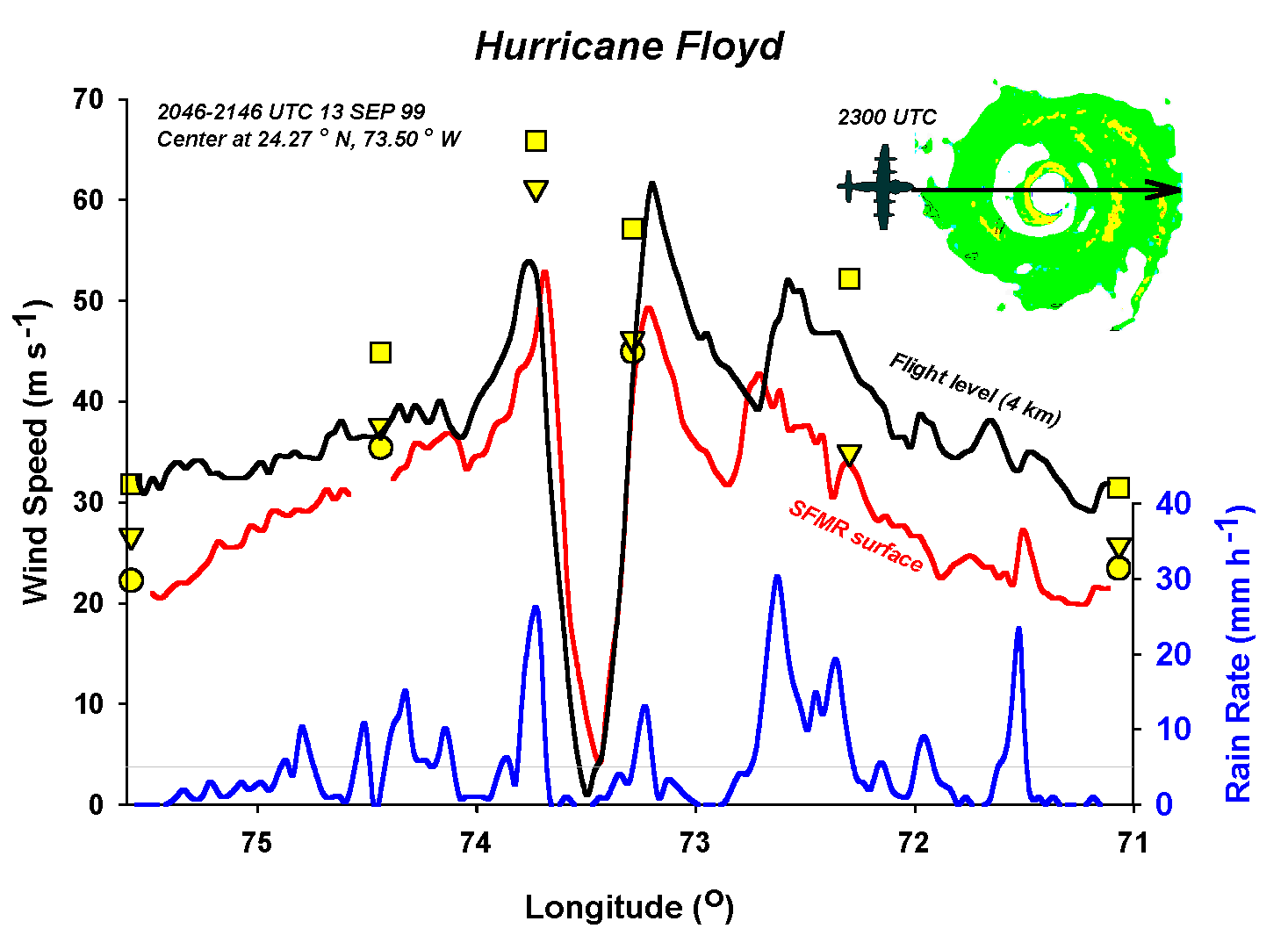
Measurement of the hurricane surface wind field, and in particular the estimation of wind maxima, has long been a requirement of the Tropical Prediction Center/OAR. The NOAA/Hurricane Research Division's Stepped-Frequency Microwave Radiometer (SFMR) is the prototype for a new generation of airborne remote sensing instruments designed for operational surface wind estimation in hurricanes.
The SFMR has a downward pointing antenna which passively reads the microwave radiation coming from the ocean surface. By making assumptions about the vertical structure of the atmosphere together with sea surface temperature measurements by a downward-looking airborne infrared radiometer, reasonable estimates of the ocean surface brightness temperature can be made at six frequencies between 4.6 and 7.2 GHz. Wind speeds are then calculated assuming linear increase in wind speed with these brightness temperatures. Since some of the frequencies are more attenuated by rainfall than others, an estimate of the rainfall rate below the airplane can also be made.
Well we have Tropical Storm Gil and Tropical Depression ELEVEN E(RESOE EDIS) off the Pacific Coast that we are keeping an eye on. There are also a couple of interesting tropical waves forming off the African Coast (see Tropical Weather Outlook and Storm Watch-Carib interactive graphics- left side of page)!
Chicago Weather for the weekend? Just great! Have a wonderful Labor Day Weekend!
NOAA NATIONAL WEATHER SERVICE SEVERE WEATHER WARNINGS TO PROVIDE MORE PRECISE LOCATION THIS FALL
Jan. 16, 2007 — The NOAA National Weather Service will introduce this fall storm-based warnings for tornadoes, severe thunderstorms, flash floods and marine hazards that are more geographically specific for these short-duration weather events. Currently, such warnings are issued county wide. (Click NOAA image for larger view of NOAA Storm-based Warnings by county versus the more geographically specific locations due to take effect in October 2007. Please credit “NOAA.”)
"Weather doesn't follow geopolitical boundaries," said retired Air Force Brig. Gen. David L. Johnson, director of the NOAA National Weather Service. "Storm-based warnings provide the public with more specific information about the location of severe weather and the direction it is expected to move. Seconds count during tornadoes and flash floods. We want to provide the public with the most accurate description of what's happening in their neighborhood. We also want to avoid warning non-threatened portions of the county."
When issuing a warning, the NOAA National Weather Service will specify areas within a county and refer to commonly known landmarks such as highways or rivers.
"This is a fundamental change in our warning procedures and a major enhancement in our service capability," said Johnson. "Storm-based warnings will drastically improve graphical displays and empower the private sector to easily distribute the information through Web-enabled PDAs, cell phone alerts, pagers and other technologies. Communicating severe weather threats in this way is imperative in today's digital world." (Click NOAA image for larger view of the improved NOAA Storm-based Warnings due to take effect in October 2007. Please credit “NOAA.”)
The new warnings will take effect October 1, 2007.
NOAA, an agency of the U.S. Commerce Department, is celebrating 200 years of science and service to the nation. From the establishment of the Survey of the Coast in 1807 by Thomas Jefferson to the formation of the Weather Bureau and the Bureau of Commercial Fisheries in the 1870s, much of America's scientific heritage is rooted in NOAA. NOAA is dedicated to enhancing economic security and national safety through the prediction and research of weather and climate-related events and information service delivery for transportation, and by providing environmental stewardship of the nation's coastal and marine resources. Through the emerging Global Earth Observation System of Systems (GEOSS), NOAA is working with its federal partners, more than 60 countries and the European Commission to develop a global monitoring network that is as integrated as the planet it observes, predicts and protects.
Our good freind Dr. Paul C. Liu of Freague Waves is reporting on two exciting new books. "It is a real life story, not a fiction, but it happened in November 22, 1980 over a decade before Sebastian Junger's Perfect storm."Take a look!
The roughness of the oceans has important consequences for seafarers and coastal communities, and is linked to the global climate system through atmospheric circulation and winds. Satellite altimetry brought a global perspective on ocean wave climate (Chelton et al., 1981). With the accumulation of lengthy and carefully validated datasets from a number of satellite altimeters, it is now possible to evaluate the seasonality and inter-annual variability of wave climate globally to a resolution of the order of 100km.
Measuring Waves with Satellite Altimeters
By convention, significant wave height is defined to be four times the root-mean-square elevation of the sea surface, and is a standard statistic for the roughness of the sea surface. Satellite altimeters measure the roughness of the sea through the blurring of the leading edge of the reflected pulses by the uneven surface. Altimeter estimates of significant wave height are corrected by calibration with high-quality buoy data (Challenor and Cotton, 2001). Altimeters only measure the roughness of the sea in a small footprint (~10km diameter) immediately below the satellite. The data sampling is sparse, but sufficient to establish monthly mean significant wave heights on a 2o latitude by 2o longitude grid, or better if more than one satellite is operational. The gridded data sets are constructed from median values of individual "passes" across each grid box. Wave heights vary rapidly close to coasts. Also, the altimeter cannot measure waves if its footprint overlaps land. Therefore, the gridded altimeter datasets provide an offshore climatology only. Data along individual satellite passes can be analysed to extend analysis nearer shore, but even then the sizeable footprint of the altimeters is a limitation. Other methods are necessary to describe waves within 10km of the coastline.
Passes in the vicinity of United Kingdom
(Topex/Poseidon/Jason in Black, ERS-&2/Envisat in Red)
Global Wave Climatology
Average significant wave height can be measured monthly over the globe by satellite altimeter. Wave height varies regionally and seasonally, monthly means mostly varying between 1 metre and 5 metres. Generally, the sea is rougher at high latitudes (North and South) than in the tropics. Wave climate in the extra-tropical North Pacific and North Atlantic is especially seasonal with much rougher conditions in the northern (boreal) winter than in the summer. The Southern Ocean is roughest in the southern (austral) winter, but is very rough throughout the year. Nearer the equator, larger waves can be either swell propagating from higher latitudes, or can be the result of seasonal winds (e.g., monsoons and tropical storms). The Arabian Sea is particularly rough from June to August coinciding with the Southwest Monsoon.
The seasonal and regional wave climate can be summarised by fitting a sinusoidal function of annual period to the monthly mean significant wave heights for each grid square. At each location, the seasonality can be represented by the annual mean, the timing of the maximum wave height (phase of the sinusoid) and the range (twice the amplitude of the sinusoid).
Global Seasonality of Waves. Top: Annual Mean (metres); Middle: Annual Range (metres); Bottom: Phase (peak in months)
North Atlantic and British Isles
There is evidence that the North Atlantic Ocean grew considerably rougher between the 1960s and 1980s, during the age of the ocean weather ships, at least at a few isolated stations (Bacon and Carter, 1991). Is this natural variability or global warming? A new perspective is brought by analysis of satellite data.
The seasonality of wave climate around the British Isles is derived from monthly gridded altimeter measurements over five complete years (1993-1997). The ocean relatively rough throughout the year, while more sheltered regions, for example around south east England, are relatively calm. The seasonality varies slightly from region to region. For example, the spring tends to be slightly rougher than the autumn to the north west of the British Isles, but the reverse is generally true in the North Sea and the Southwest Approaches.
Seasonality of wave climate around the UK
The seasonal cycle is a fair representation of the average climate in the 1990s. However, there is also a great deal of variability about the mean in individual years. This is especially true during the winter months in the Atlantic and Atlantic margins, with monthly mean significant wave heights changing by up to a factor of two from one year to the next. The most obvious candidate as a source for this variability is the North Atlantic Oscillation (Hurrell, 1995), which has a widespread effect on many facets of climate, particularly in the months of December to March. We use gridded mean significant wave heights from these four calendar months in six consecutive winters, 92/93 -97/98. For each of the 24 months, "anomalies" are calculated by subtracting the mean seasonal cycle. Principal component methods are used to derive a spatial pattern of significant wave height anomalies whose time-dependent amplitudes are maximally correlated to an NAO index (Jones et al., 1997). A model for the anomalies is constructed by using the spatial pattern to calculate coefficients of a linear model relating the monthly anomaly to the monthly NAO index.
Inter-annual variability of wintertime wave climate
(above, spatial pattern of 1st eof; below, principal component (red crosses) and NAO Index (black squares)
The performance of the model is illustrated at a single location (57o-58oN, 8-10oW) on the edge of the Hebridean shelf. This location is typical of the region to the north west of the British Isles where inter-annual variability is greatest. Measured anomalies in excess of 2 metres (above or below the means of about 5 metres in each of the four calendar months) are recorded. These anomalies are well described by the relationship to the NAO. In other regions around the British Isles, the variability is lower and the model is less successful in describing this variability. However, the NAO is apparently a factor in determining wave climate throughout the area with the exception of the East Coast of England and Scotland.
Satellite altimetry provides a consistent coverage of wave climate around the British Isles. Previously, wave climatologies were constructed from measurements at a variety of sites and times (Draper, 1980 and 1991). The new climatology is based on measurements in the 1990s and reflects changes in wave climate since earlier decades (Bacon and Carter, 1991; Alcock and Rickards, 2001). Satellite data indicates that an upward trend in wave heights continued from the late 1980s into the early 1990s (Carter, 1999), but the behaviour during the 1990s was erratic. This behaviour can be explained by the NAO, which shifted towards more positive index values between the early 1960s and late 1990s before dramatically switching to its negative phase in the winter of 95/96. The relationship to the NAO is robust and can be used to hindcast the wave climate in much earlier times (Woolf et al., 2002).
Validation of NAO relationship at OWS Lima, extending back to the 1970s.
Behaviour of the NAO in recent decades (9-year running mean)
Hindcast of recent changes in wave height due to NAO.
MASTER ENDEAVOUR driven aground by hurrican 'Dean', in Fort de France bay (Martinique - FWI), night 16-17 Aug 2007. The ship was anchored in the bay without crew, under arrest for drug smuggling.
The Maritime New Zealand report of the M/V Aratere incident has just been released. while it was determined that the vessel was constructed to take the large wave pounding.
I want you to note the damage done to this vessel, its crew and passengers.
Imagine a 44 ft sailboat like the Sean Seamour II taking these waves?
Maritime New Zealand issued the report of its investigation into the incident onboard a passenger ferry that experienced heavy rolling and cargo shifts during severe weather. Four passengers and one crewmember were injured and there was significant cargo damage. The report recommends, among other things, further review of weather parameters for Cook Strait crossings and improved training of bridge personnel for ship handling in heavy weather. (Report pdf Aratere 8/23/07).
The ships particulars include: Year Built 1998. Builder: Astillero Barreras, Spain. Introduced: 1999. Gross tonnage: 12,300 t. Flag: New Zealand. Passenger capacity: 369. Rail wagon capacity:60 (425 m). Car capacity: 230. Length: 150m. Breadth: 20.25m. Maximum speed: 19.5kt. Engines:2x Wartsila type 8L32 diesel engines, each producing 3,680 kW.
We previewed this vessel the Strait Shipping Company "Suilvan" back on June 8, 2007 with a post titled "Another Plane Of View". Speaking about how large waves effect large ships with this video from a shore-base view.
Aratere heavy weather report released
Thursday, 23 August 2007, 12:13 pm Press Release: Maritime New Zealand Media release
DATE
STRICTLY EMBARGOED UNTIL NOON 23 AUGUST 2007
Aratere heavy weather report released
Improvements have been made to the way Cook Strait ferries are operated in rough weather following a thorough investigation into the heavy rolling of the Aratere on 3 March 2006.
In releasing Maritime New Zealand’s final report into the incident today (Thursday 23 August), Director Catherine Taylor said while the vessel was capable of withstanding the heavy rolls it encountered, all parties involved accepted that passengers should not have been put in such a position.
“Passenger safety is Maritime New Zealand’s number one priority. This is why we’ve conducted a rigorous investigation, which contains 14 safety recommendations that have already been implemented to improve heavy weather sailing in Cook Strait. This is to ensure that passengers aren’t placed in a situation like this again.”
The report found that during the voyage in rough seas, the Aratere rolled twice to about 50 degrees, with a third roll of approximately 30 degrees occurring when an attempt was made to turn the vessel into the weather.
“Maritime New Zealand considers that although the Aratere itself was sound and was capable of handling the rough seas it encountered, this was still a very serious incident which was understandably very upsetting and uncomfortable for many on board.”
The heavy rolling caused minor injuries to five of the 381 people on board and caused some cargo to break free, damaging rail and vehicular freight. The Aratere arrived safely in Picton several hours later. Other vessels operating in Cook Strait at the same time completed their voyages without incident.
Ms Taylor said MNZ’s final report had considered a wealth of evidence, including eye witness accounts, the advice of overseas experts and technical information from the ship’s voyage data recording instruments. “Based on this evidence, MNZ has concluded that a combination of factors caused the Aratere to roll heavily. While the heavy rolling would have been alarming for those on board, the technical evidence we received appears to conflict with reports that the ship was in serious danger.”
Ms Taylor said the final report also considered the seamanship displayed during the voyage, including the actions of the master and bridge team, as well as issues relating to the cargo lashing system.
“While the report found that the decision to sail was reasonable based on the information available at the time, both Interislander and Maritime New Zealand consider that teamwork on the bridge following the first heavy rolling incident was not functioning as effectively as it should have been.
“Both organisations have been working closely together to address this issue and have implemented a number of safety recommendations.”
Among the actions taken by Interislander is a full review of decision-making relating to rough weather crossings, additional training for ferry masters and crew, improvements to cargo lashing systems and significant investment in overhauling and upgrading the ferries Aratere, Arahura and Kaitaki. Maritime New Zealand has also improved its process for distributing information to ferry companies.
“The purpose of all incident investigations is for the parties involved to learn from them to improve safety, and this is exactly what has happened in this case. Maritime New Zealand’s number one priority is, as always public safety, and we will continue to work with all ferry operators to ensure that the Cook Strait remains a safe place for all to travel.”
Ms Taylor said the report commended the Aratere’s on-board staff for the level of care they displayed towards the passengers during the voyage, and the way in which they kept them informed of the developing situation.
The Transport Accident Investigation Commission also today released its final report into the incident.
ENDS
Safety Recommendations implemented following 3 March 2006 incident
1. It is recommended that Maritime New Zealand:
- Facilitates discussions between the Interislander, Strait Shipping, Wellington Regional Council, Marlborough Regional Council, and the Wellington and Marlborough Harbourmasters through the Cook Strait Ferry Review. These discussions should consider appropriate weather parameters for ferry sailings, including the need for harbourmasters to be consulted on the appropriateness of ferries sailing when wave heights and wind speeds reach certain levels. These discussions have already occurred and are ongoing.
- Continues to conduct ongoing audits of Bridge Resource Management, navigational practice and the lashing system on Aratere and examination of cargo manifests of rail wagons carried, for compliance with the amended Cargo Securing Manual. Ongoing.
- Conducts ongoing audits of all Cook Strait ferries to ensure that trucks are lashed in accordance with the cargo lashing manual. Ongoing.
- Conducts ongoing audits to monitor the implementation of corrective actions proposed by Interislander. Ongoing.
- Reviews its procedures for promulgating safety information, including pertinent IMO circulars. Completed.
2. It is recommended that Interislander:
- Reviews and documents its procedures for downloading VDR information following an accident or incident and ensures that ships’ masters and officers have the knowledge and ability to do so. Completed.
- Ensures that helmspersons on its vessels are adequately trained and practised so that they can competently steer the vessel in all weather conditions. Completed.
- Conducts random, unannounced, command assessments of its masters and officers to check their knowledge of the equipment they use and its limitations, and knowledge of, and compliance with, company procedures. Ongoing.
- Formalises a policy that Masters and, if appropriate, officers and crew, are stood down from duty following a significant accident or incident for recovery, and to ensure their availability for internal and external investigations. Completed.
- Resolves confusion over optimum rudder angles, in particular the operating conditions applicable to high-lift rudders. Completed.
- In conjunction with its ships’ masters, review the use of stabilisers when running down weather in heavy weather conditions, and in particular when there is a risk that the vessel may be subject to surf riding. Completed.
- Require masters and deck officers to undergo initial training in heavy weather ship handling followed by regular refresher training. Completed.
- Extend the simulation modelling being carried out by naval architects into ship/tide/weather interactions in the Cook Strait, to include interaction between the ship and conditions likely to be experienced in the entrance channel to Wellington Harbour and the eastern entrance to Tory Channel in severe southerly weather. Completed.
- Provide MNZ with the results of any internal investigation and follow up action as a matter of course, rather than being required to do so. Ongoing.
ENDS
Weather Story ...Well here is the rain totals for Chicago from from July through August by Northern Illinois University... After a major event (we're still awaiting official word from the USGS and hydrologists on what type of event this was, IE, one in a 50 or 100 year flood, etc), people have been asking if that was a record rainfall we had last week.Rockford and Madison, WI have had their wettest Augusts ever, so how are we doing?
To answer that question, let's look at July and August 2007 up until today.
July 2007: 8.20" August 2007 (so far): 11.64"
July-August 2007 combined rainfall total: 19.84" The top 4 wettest Augusts ever:1. 14.23" -1987 2. 11.64" -2007 3. 11.17" -1900 4. 10.94" -1937
The top wettest July-August combined totals ever:20.14" -198719.84" -200717.58" -199616.77" -1900
We still have essentially 3 more days to go to add to the totals. There is a possibility that if we get .30" of rain Tuesday evening into Wednesday, we would tie the wettest July-August combined ever.
Finally, I had two brief periods to go out and take a few pictures of the flooding here on campus on Friday.
I took these around Barsema Hall, Gilbert Hall/Music building, Castle Drive, inbetween Faraday and Faraday West, and from my perch here on Davis Hall (the silly flash wouldn't shutoff on those pictures---sorry about that):http://weather.admin.niu.edu/floodof2007/But still, some good pix in there nonetheless.
Yes, that's an upset beaver in there on Castle Drive, annoyed that his dam is now somewhere on the Mississippi River. He walked right in front of me, but I didn't have my camera ready at that moment.
Also, Dr. Walker Ashley, a meteorology professor here at NIU, who had more time, got a considerably better variety and angle of shots:http://thetae.blogspot.com
Thanks to Dave Changnon for the help in acquiring the data, and to the 220,000 on and off-campus visitors *each day* between Wednesday and Friday of last week who used our site, setting a usage record in our nearly 9 year history!
USAID Assists Latin America and Caribbean After Hurricane Dean
August 22, 2007
Street Corner in Kingston, Jamaica one day after Hurricane Dean
Traffic light down in Kingston one day after Hurricane Dean
BACKGROUND AND KEY DEVELOPMENTS
On August 21, Hurricane Dean was downgraded from a category five to a category one hurricane on the Saffir- Simpson scale as it crossed Mexico’s Yucatan Peninsula and northern Belize. The storm continued across the Bay of Campeche on August 22, making landfall at 1230 hours eastern standard time near the town of Tecolutla, 40 miles south-southeast of Tuxpan, having strengthened slightly to a category two hurricane. According to the U.S. National Hurricane Center, Dean is expected to weaken as it moves inland.
Impact assessments are ongoing in Belize and Mexico, but early reports indicate less damage than originally expected.
Beginning on August 17, Hurricane Dean passed through the Eastern Caribbean as a category two storm, strengthening to category four as it moved across Jamaica. The hurricane caused damage in St. Lucia, Dominica, Jamaica, Haiti, Dominican Republic, and Martinique. The most damage reported to date is in Jamaica.
In response to the impact of Hurricane Dean in Jamaica, USAID/OFDA has dispatched relief commodities including 420 rolls of plastic sheeting, 6,250 blankets, 5,000 ten-liter water containers, and 2,592 hygiene kits. The commodities arrived in Kingston on August 22. The total value of all items, including transport, is more than $297,000.
On August 22, USAID/OFDA provided $100,000 to the Pan American Health Organization (PAHO) to respond to emergency health needs resulting from Hurricane Dean in Jamaica. To date, USAID/OFDA has provided more than $570,000 to support emergency response activities in Jamaica.
1 dead, 300 houses destroyed or partially destroyed, 1,600 persons in shelters
PAHO- August 21, 2007
Haiti
4 dead 2,000 families affected
OCHA2- August 19, 2007 IFRC3 – August 22, 2007
Jamaica
3 dead, 3,500 people in shelters 3,500 confirmed affected in areas assessed*
ODPEM4, August 21, 2007 USAID Assessment Team – August 21, 2007
Martinique
1 dead
OCHA- August 19
Saint Lucia
1 dead
OCHA- August 19
*Figures based on very preliminary figures. 1 Caribbean Disaster Emergency Response Agency (CDERA) 2 U.N. Office for the Coordination of Humanitarian Assistance (OCHA) 3 The International Federation of Red Cross and Red Crescent Societies (IFRC) 4 The Government of Jamaica’s Office of Disaster Preparedness and Emergency Management (ODPEM)
FY 2007 HUMANITARIAN FUNDING PROVIDED TO DATE
USAID/OFDA Assistance to Jamaica: $572,243 Total USAID Humanitarian Assistance to the Caribbean: $572,243
CURRENT SITUATION
Jamaica
On August 21, USAID disaster response specialists joined field assessments led by ODPEM to five severely affected communities. The teams reported extensive damage in the area of Old Harbour Bay in Saint Catherine Parish, where hurricane force winds demolished an estimated 80 percent of the houses and left thousands in need of relief assistance. These initial assessments also noted that Hurricane Dean killed three people, damaged thousands of houses, and left at least 3,500 people in need of food, water, and relief supplies. The USAID assessment team believes that the number of affected will continue to rise as results from other field assessments become available. Field assessments will continue on August 22.
According to ODPEM, although Hurricane Dean struck the island on August 19 as a category four hurricane, the storm did less damage to the island’s infrastructure than was initially anticipated. In contrast to previous hurricanes, such as the destructive Hurricane Ivan in 2004, Hurricane Dean moved quickly through Jamaica, resulting in less heavy rainfall and landslides.
Belize
According to USAID's disaster response specialist in Belize, Hurricane Dean destroyed more than 650 homes and displaced more than 1,600 people. However, the storm did not cause any major damage to infrastructure, and Belize’s international airport and seaports have reopened.
On August 21, U.S. Embassy staff conducted an aerial assessment utilizing two U.S. military helicopters, to determine the extent of hurricane damage in Belize. The overflight revealed some roof and crop damage, but overall was much less than initially expected.
Mexico
USAID emergency staff are conducting preliminary damage and needs assessments in the affected areas of Mexico, but reports to date indicate that because of excellent disaster preparedness planning and actions taken by the Government of Mexico (GOM), no one died in the Yucatan Peninsula as a result of Hurricane Dean and property damage was less than expected.
Cancun International Airport did not sustain significant damages during the hurricane, and the airport is on stand-by to receive flights carrying relief supplies in the event that the areas impacted by Hurricane Dean require assistance. To date, 85 percent of cellular communication is operating and public transportation and water services have resumed normal operations in Cancun, according to the Municipal Office of Public Works.
As of August 21, the Chetumal Airport remained closed, and public transportation has not resumed operations.
USG HUMANITARIAN ASSISTANCE
USAID/OFDA is monitoring Hurricane Dean’s track and impact from the Latin America and Caribbean (LAC) Regional Office in San Jose, Costa Rica, as well as from Washington, D.C. USAID/OFDA staff are currently in Barbados, Belize, Dominica, the Dominican Republic, Guatemala, Haiti, Honduras, Jamaica, Mexico, and Nicaragua. In total, 22 USAID/OFDA emergency staff are deployed to respond to the impact of Hurricane Dean.
Jamaica: On August 20, U.S. Ambassador to Jamaica Brenda LaGrange Johnson declared a disaster due to the damage caused by Hurricane Dean. In response to the impact of the hurricane, USAID/OFDA has dispatched relief commodities to Jamaica. The commodities, which include 420 rolls of plastic sheeting, 6,250 blankets, 5,000 ten-liter water containers, and 2,592 hygiene kits, are scheduled to arrive in Kingston on August 22. The total value of all items including transport is $297,243. USAID/OFDA has also provided $100,000 to support emergency health services through PAHO and $175,000 to ODPEM for emergency relief supplies. A six-member USAID assessment team, which arrived in Jamaica on August 18, continues to conduct assessments and coordinate response efforts with U.N. agencies, Government of Jamaica authorities, non-governmental organization (NGO) partners, donors, and other disaster assessment teams.
Mexico: On August 19, in advance of Hurricane Dean, USAID deployed three disaster response specialists to the Yucatan as well as a three-person team to Mexico City to work closely with the USAID mission, U.S. Embassy, and the GOM. The response specialists are currently conducting joint damage assessments with Mexican disaster responders. Two USAID emergency staff are traveling to areas around Vera Cruz to support assessments following Hurricane Dean’s second landfall. However, no U.S. assistance has been requested by the GOM.
Since 2000, USAID has provided more than $142 million in response to the devastating effects of hurricanes and tropical storms throughout Central America and the Caribbean.
Weather Story
The Chicago storms of August 23 and 24th brought some very interesting and severe weather to the region. Here is one of the storm captured by Storm Chaser John Farley onAugust 24, 2007 in Madison County, Illinois
While we were tracking Hurricane Dean in the Gulf of Mexico, we here in Chicagoland had our own interesting weather for the past few days. Thursday August 23, 2007 was the worse.
(Photos and story courtesy WGN Weather Blog). Matter of fact the entire region from Iowa to Indiana to Illinois to Michigan suffered from severe storms.
NIU DeKalb Campus declared an emergency closure. In a statement the university stated;
"Due to potentially worsening flood conditions on our DeKalb campus, the university has declared an emergency closure and urges those personnel who are not designated as essential to emergency services to leave campus as soon as possible.
Only two bridges in DeKalb are currently passable, and with additional rain forecast, travel throughout the county is likely to grow increasingly difficult as the day goes on.Due to the status of this action as an emergency weather closure, personnel will not need to use leave time.The university*s regional centers in Rockford, Naperville and Hoffman Estates are not affected by this closure and remain open. Please use caution in traveling due to flooding road conditions."
Thursday was some of the worse weather Chicago has seen in years.
I was downtown during the height of the storm and clocked wind gusts at 63 MPH along N. Michigan Avenue, with wind driven rain where most trying to walk N. Michigan Avenue were doing so without much success. To say the least, umbrellas were useless.
Damage in my immediate area was limited to fallen trees around N. Michigan and Lakeshore Drive. Flooding was extensive along Lakeshore with beach access tunnels flooded. Ohio Street beach also flooded.The lightning show was just fascinating as well as dangerous.
Here are just some of the other damage reports from the region.
310,000 powerless in Chicago area
The Associated Press
A fast-moving storm packing winds over 70 mph turned skies from day to night across a wide swath of the Chicago area Thursday, damaging homes and businesses, splitting trees and bringing planes and trains to a halt.
About 310,000 customers in northern Illinois were without power Thursday night, including 62,000 in Chicago, said ComEd spokesman Tom Stevens, who added that it could take days to restore power for some customers north of the city.
People who ventured out to survey the storm's aftermath dodged felled trees, downed power lines and other debris knocked about by high winds.
Chicago officials said the city's emergency center been called for nearly 1,300 "tree emergencies," which included uprooted and split trees and limbs blocking intersections.
Langford said trees in several areas of the city hit power lines and exploded transformers, setting utility poles on fire.
"This is not a storm that's isolated," said Chicago Fire Department spokesman Larry Langford. "This one hit the entire city north to south."
A roof collapsed at the dock area of an industrial building in the suburbs, injuring 40 people, authorities said. West Chicago Police Department spokesman Mike Uplegger said seven people were sent to hospitals and the rest refused treatment at the scene. None of the injuries was considered life threatening.
A large piece of metal scaffolding at Northwestern Memorial Hospital's Prentice Women's Hospital collapsed during the storm, and two people suffered minor injuries but refused treatment, Langford said. Also, the rear wall of a four-story building under construction on Chicago's North Side collapsed, but no injuries were reported, he said.
Officials warned residents to prepare for flooding, with one to two inches of rain drenching on an already waterlogged area.
"That's what we're worried about right now," said National Weather Service meteorologist Nathan Marsili. "It could turn out to be a pretty bad flooding situation for the area."
Elizabeth Schreiber, who works at a public relations firm in Chicago, was in a cab returning from a work lunch when she looked out the window and noticed a tree had smashed into her 1998 Toyota Camry.
The uprooted tree lay across two other vehicles and her car, completely crushing its roof.
"It looks crazy around here," she said while waiting for help. "It's really bad."
Matt Steinkraus, 29, of St. John, Ind. — in Chicago for his wedding on Saturday — was walking downtown with his fiancee and friends when the storm struck.
"As soon as it hit, we made a break for the nearest bar," he said. "We got drenched ... then we went into the bathroom, wrung out our shirts, ran them under the dryer."
About 500 flights were canceled at O'Hare International Airport Thursday evening and passengers should expect delays of more than 2 1/2 hours, according to Chicago Aviation Commissioner Nuria Fernandez. Delays at Midway Airport averaged 1 1/2 to 2 hours.
Judy Pardonnet, a spokeswoman with Metra commuter rail system, said there were delays throughout the system because of debris on the tracks and malfunctioning signals.
"It's going to be a slow commute home for us," she said.
The National Weather Service would not be able to confirm tornado touchdowns until Friday, meteorologist Gino Izzi said. He said 74 mph wind gusts were recorded in Midlothian and near Wrigley Field.
As the storms rolled through, officials feared flash flooding. Some areas of northern Illinois could see 3-5 inches of rain — of particular concern because the ground is so saturated with water from recent rains, Izzi said.
"If that happens, you could be talking very serious flooding," Izzi said.
In Fox Lake in far-northern Illinois, the Fox River flooded some homes while other residents stacked sandbags to protect their houses, said Ami McEwan, assistant administrator for Lake County.
"Most of them are sandbagging and keeping it at bay," she said.
In downtown Gurnee, just west of Waukegan, workers were stacking sandbags to protect an elementary school from the Des Plaines River, she said. School hadn't yet started for the fall, so no students were affected.
A foot of water stood over roads in the Rochelle area, about 20 miles west of De Kalb, and the Des Plaines River was more than 3 feet above flood stage north of Waukegan, according to the weather service.
An afternoon storm that included high winds uprooted trees and damaged homes and knocked out power across Galesburg, about 40 miles northwest of Peoria, according weather service and local authorities. The storm also blew the windows out of a church in nearby Toulon, and knocked out power lines across Stark County, just north of Peoria.
Trees and limbs were down all over town, but no one was hurt by the fast-moving storm, Galesburg Fire Department Battalion Chief Brad Stevenson said.
"It was such a broad area, and it came up so quick and was gone so quick," he said.
By SARAH LEFEBER REGISTER STAFF WRITER August 24, 2007
Humboldt County's disaster services coordinator is in serious condition in a Mason City hospital after his vehicle struck a utility pole while he was assessing storm damage Tuesday night.
Humboldt County Sheriff Dean Kruger said Doug Wood was driving near Bode when he hit a pole that had fallen during the storm.
Kruger said he was talking to Wood on his cell phone about 8:30 p.m. as Wood was driving on County Road P-33. "The next thing I heard was 'Oh no,' and then I heard a clunk, and that was the last contact I had with him," Kruger said.
When officers found Wood, his vehicle was in a ditch with power lines down on the road around him. Rescuers waited about 30 minutes for MidAmerican Energy to shut off the power before they were able to get Wood out of his vehicle.
Wood was taken by ambulance to a Humboldt hospital and transferred to Mercy Medical Center in Mason City. He remained in serious condition with a severe head injury.
Reporter Sarah Lefeber can be reached at (515) 284-8065 or slefeber@dmreg.com
Here is a summary by NWS.
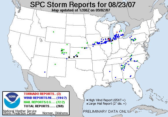
738NOUS43 KLOT 250048PNSLOTPUBLIC INFORMATION STATEMENT NATIONAL WEATHER SERVICE CHICAGO IL747 PM CDT FRI AUG 24 2007.
..STORM SURVEYS CONDUCTED ACROSS PORTIONS OF DEKALB...DUPAGE ANDCOOK COUNTIES...
...STRAIGHT LINE WIND DAMAGE FOUND ACROSS DUPAGE AND COOK COUNTIES...
SEVERE THUNDERSTORMS CAUSED EXTENSIVE WIND DAMAGE ACROSS PORTIONS OF NORTHERN ILLINOIS THURSDAY AFTERNOON.
NATIONAL WEATHER SERVICE STORM SURVEY TEAMS EXAMINED WIND DAMAGE IN SEVERAL LOCATIONS ACROSS DEKALB...DUPAGE AND COOK COUNTIES ON FRIDAY.ACROSS DUPAGE AND PORTIONS OF NORTHERN AND CENTRAL COOK COUNTIES...A NEARLY CONTINUOUS SWATH OF WIND DAMAGE WAS NOTED. THE MOST SIGNIFICANT DAMAGE OCCURRED ALONG A PATH WHICH BEGAN IN FAR WESTERN DUPAGE COUNTY NEAR THE INTERSECTION OF ROOSEVELT ROAD AND WASHINGTON STREET
IN WEST CHICAGO...AND CONTINUED EAST THROUGH THE NORTHERN PORTIONS OF LOMBARD AND GLEN ELLYN...INTO NORTHLAKE...THEN ACROSS THE NORTH SIDE OF CHICAGO TO THE LAKE MICHIGAN SHORE NEAR MONTROSE HARBOR. ALONG THIS PATH...WIND DAMAGE WAS CONSISTENT WITHWINDS IN THE 60 TO 80 MPH RANGE.
HOWEVER...THERE WERE POCKETS OF WIND DAMAGE SUGGESTIVE OF WINDS IN THE 80 TO 100 MPH RANGE INCLUDING THE 4200 BLOCK OF NORTH ASHLAND AND ACROSS NORTHERN GLEN ELLYN SOUTH OF GENEVA ROAD. THE WIND DAMAGE WAS APPROXIMATELY ONE HALF MILE WIDE ALONG THIS PATH. A SEPARATE AREA OF WIND DAMAGE SUGGESTIVE OF WINDS OF 80 TO 100 MPH WAS FOUND IN THE 4000 BLOCK OF NORTH SHERIDAN INTHE WRIGLEYVILLE AREA WITH EXTENSIVE TREE DAMAGE AND SEVERAL UPROOTED TREES IN THIS AREA. MUCH OF THE DAMAGE APPEARS TO BE CONSISTENT WITH STRAIGHT LINE WINDS...WITH NO SIGNS OF SUSTAINED ORORGANIZED CIRCULATION OVER THE MAJORITY OF THE DAMAGE PATH....
EF1 TORNADO DAMAGE FOUND IN WESTERN DUPAGE COUNTY...WHILE OTHER DAMAGE APPEARS TO HAVE BEEN CAUSED BY STRAIGHT LINEWINDS...DAMAGE INDICATING A TORNADIC CIRCULATION WAS FOUND IN WINFIELD IN WESTERN DUPAGE COUNTY. THE TORNADO BEGAN NEAR PRINCE CROSSING ROAD SOUTH OF GENEVA ROAD. THE TORNADO HAD A PATH LENGTH OF APPROXIMATELY 1.5 MILES AND ENDED JUST WEST OF GARY AVENUE SOUTH OF GENEVA ROAD. THE MAIN DAMAGE FROM THE TORNADO INCLUDED SEVERAL LARGE UPROOTED HARDWOOD TREES. BASED ON THE OBSERVED DAMAGE...THE TORNADO IS ESTIMATED TO HAVE BEEN APPROXIMATELY 300 TO 500 YARDS WIDE AND RATED EF1 ON THE ENHANCED FUJITA SCALE WITH ESTIMATED WIND SPEEDS OF 86 TO 110 MPH. PRELIMINARY REVIEW OF RADAR DATA AND SPOTTER REPORTS INDICATE THAT THE TORNADO OCCURRED AT APPROXIMATELY 308 PM CDT....
ADDITIONAL SURVEYS...
IN DEKALB COUNTY....MINOR STRAIGHT LINE WIND DAMAGE TO LIMBS AND A SHED DOOR WERE FOUND ACROSS THE MILAN...AFTON...PIERCE AND KANEVILLE TOWNSHIPS SOUTH AND SOUTHEAST OF THE CITY OF DEKALB.IN MOUNT PROSPECT IN NORTHERN COOK COUNTY...ROOF AND EXTERIOR WALL DAMAGE WAS NOTED TO A ONE STORY GARAGE BUILDING IN AN APARTMENT COMPLEX SOUTHWEST OF THE INTERSECTION OF GOLF ROAD AND BUSSE ROAD.
DAMAGE APPEARED TO BE ASSOCIATED WITH STRAIGHT LINE WINDS OF 80 TO 100 MPH. THROUGHOUT THE VILLAGE...NUMEROUS LARGE BROKEN TREE LIMBS...SOME UPROOTED TREES AND A FEW SNAPPED TREE TRUNKS ALSO APPEARED TO BE CONSISTENT WITH PEAK STRAIGHT LINE WIND SPEEDS OF 80 TO 100 MPH.
Severe storms moved through northeast Illinois (Chicago area) in the afternoon on August 23, 2007, causing power outages, downed trees, and roof damage to several buildings.
One fatality has been confirmed in Knox County due to a falling tree. No other injuries have been reported to the State.
Power outages have been reported in Cook County, Knox, LaSalle and Warren Counties.
At 3:30 pm CDT, August 23, 2007 the Exelon Nuclear Power Plant at Braidwood had one unit manually shut down by the operators due to loss of vacuum. The loss of vacuum was caused by the automatic shut down of 2 circulating water pumps when the pumps experienced fluctuations. This is standard protocol with this type of mechanical failure and the reactor was shut down without incident.
Braidwood Unit 1 is still at power and both reactors at the Braidwood site are stable. This is not a classifiable incident under NRC regulations and poses no danger to the public or the workers at the station. The US NRC has been notified. The IEMA resident inspector is on-site.
The majority of damages reported have been minor.
The State EOC is being staffed, but has not been activated. The State has requested Illinois State Patrol, Illinois Department of Transportation, Illinois Department of Natural Resources, External Affairs and a Legislative Liaison to report to the EOC. There have been no requests for State Assistance. Continue reading...
As if we have not had enough rain for the past few days! UPDATE: Good news...a line of severe thunderstorms has formed over central Illinois and will keep us from getting the really nasty ones.
Furthermore, the upper disturbance now in southeastern Iowa has taken a jog south.
We will still see scattered showers and thunderstorms through tonight, but amounts should be a half inch or less, for the most part. That said, the flood warnings continue through 12:15 PM tomorrow for creeeks and streams, but the Kishwaukee River crested around noon at 15.24', the second highest crest ever recorded. The National Weather Service has also dropped their new flash flooding risk to us to slight, and just barely:
The NWS is continuing the flood watch in the event we do get a half inch of rain tonight, which would cause the rivers and streams to rise back up a bit.
Storm Damage - August 23, 2007 - 2100hrs
8/23/07, 9 PM
STATEMENT: Damage reports from Thursday, 8/23 Courtesy of the National Weather Service from various sources.
019 NWUS53 KLOT 240210 LSRLOT
PRELIMINARY LOCAL STORM REPORT...SUMMARY NATIONAL WEATHER SERVICE CHICAGO/ROMEOVILLE IL 909 PM CDT THU AUG 23 2007
0235 PM TSTM WND GST 2 N OTTAWA 41.38N 88.84W 08/23/2007 M70.00 MPH LA SALLE IL TRAINED SPOTTER
0240 PM TSTM WND GST OTTAWA 41.35N 88.84W 08/23/2007 M63.00 MPH LA SALLE IL PUBLIC
0250 PM TSTM WND DMG ELBURN 41.89N 88.47W 08/23/2007 KANE IL TRAINED SPOTTER
TREE DOWN ON FRANCIS ROAD
0250 PM TSTM WND DMG MERRILLVILLE 41.47N 87.33W 08/23/2007 LAKE IN OTHER FEDERAL
NUMEROUS LARGE TREES DOWN...SOME ON HOMES AND CARS. 30 TO 40 INCH DIAMETER TREES DOWNED...SOME UPROOTED AND SOME SNAPPED. SIGNIFICANT DAMAGE DONE TO HOMES.
0254 PM TSTM WND DMG MORRIS 41.37N 88.43W 08/23/2007 GRUNDY IL EMERGENCY MNGR SEVERAL 8 TO 10 INCH DIAMETER TREE LIMBS DOWN AND 30 FOOT SECTION OF CORN FIELD FLATTENED. SARATOGA ROAD 1 MILE NORTH OF INTERSTATE 80
0255 PM FUNNEL CLOUD 4 W GENEVA 41.88N 88.39W 08/23/2007 KANE IL TRAINED SPOTTER
ROTATING WALL CLOUD 1 MILE SOUTH OF US 38
0255 PM FUNNEL CLOUD MAPLE PARK 41.91N 88.59W 08/23/2007 KANE IL TRAINED SPOTTER
ROTATING WALL CLOUD AT US 38 AND KANE COUNTY LINE
0255 PM HEAVY RAIN GENEVA 41.88N 88.31W 08/23/2007 M0.85 INCH KANE IL TRAINED SPOTTER
20 MINUTE RAINFALL MEASUREMENT
0302 PM TSTM WND GST BATAVIA 41.85N 88.30W 08/23/2007 M62.00 MPH KANE IL LAW ENFORCEMENT FROM KANE COUNTY EOC
0302 PM FUNNEL CLOUD SUGAR GROVE 41.77N 88.46W 08/23/2007 KANE IL LAW ENFORCEMENT
AT INTERSTATE 88 AT SUGAR GROVE
0304 PM TSTM WND GST WEST CHICAGO 41.89N 88.22W 08/23/2007 M67.00 MPH DUPAGE IL ASOS
DUPAGE COUNTY AIRPORT ASOS GUST
0305 PM TSTM WND DMG WEST CHICAGO 41.89N 88.22W 08/23/2007 DUPAGE IL LAW ENFORCEMENT
*** 40 INJ *** BUILDING COLLAPSE ON FENTON AVENUE. 40 INJURED...7 WENT TO HOSPITALS
0334 PM TSTM WND DMG CRETE 41.45N 87.62W 08/23/2007 WILL IL TRAINED SPOTTER 6 INCH DIAMETER TREE DOWN
0334 PM HEAVY RAIN BATAVIA 41.85N 88.30W 08/23/2007 M0.00 INCH KANE IL PUBLIC
1.19 INCHES OF RAIN IN 30 MINUTES.
0334 PM TSTM WND DMG OAK PARK 41.89N 87.79W 08/23/2007 COOK IL PUBLIC
SEVERAL LARGE TREES DOWN AROUND CITY OF OAK PARK
0335 PM TSTM WND DMG MORTON GROVE 42.04N 87.79W 08/23/2007 COOK IL TRAINED SPOTTER MULTIPLE LARGE TREES DOWN IN RESIDENTIAL AREA NEAR GOLF ROAD AND SHERMER ROAD
0335 PM TSTM WND GST NORTHBROOK 42.13N 87.83W 08/23/2007 M57.00 MPH COOK IL AMATEUR RADIO
MEASURED AT 2 LOCATIONS IN NORTHBROOK. LARGE BRANCHES DOWN.
0339 PM FLOOD DOWNERS GROVE 41.80N 88.02W 08/23/2007 DUPAGE IL TRAINED SPOTTER
3 TO 4 INCHES OF WATER ON MAIN STREET BETWEEN 63RD AND 55TH STREET
0340 PM TSTM WND GST CHICAGO 41.88N 87.63W 08/23/2007 M74.00 MPH COOK IL MESONET
MEASURE NEAR WRIGLEY FIELD
0340 PM FLOOD ELK GROVE VILLAGE 42.01N 87.99W 08/23/2007 COOK IL TRAINED SPOTTER
0.74 INCHES OF RAIN IN 20 MINUTES WITH STREET FLOODING
0340 PM TSTM WND DMG CHICAGO 41.88N 87.63W 08/23/2007 COOK IL TRAINED SPOTTER 16 INCH DIAMETER TREE DOWN NORTH FAIRFIELD NORTH SIDE OF CHICAGO ESTIMATED 60 MPH
0340 PM TSTM WND DMG CHICAGO 41.88N 87.63W 08/23/2007 COOK IL PUBLIC WINDOWS BLOWN OUT AT CHICAGO HISTORICAL SOCIETY NEAR FULLERTON AND LAKE SHORE DRIVE
0340 PM MARINE TSTM WIND 2 E CHICAGO 41.88N 87.59W 08/23/2007 M73.00 MPH LMZ741 IL C-MAN STATION 63 KNOT GUST AT CHICAGO HARRISON CRIB
0340 PM TSTM WND DMG MUNSTER 41.55N 87.50W 08/23/2007 LAKE IN PUBLIC
10 INCH DIAMETER TREE DOWN BLOCKING SOUTHMOR ROAD SOUTH OF MORRIS
0400 PM FLOOD CHICAGO 41.88N 87.63W 08/23/2007 COOK IL TRAINED SPOTTER HIGH STANDING WATER IN LEFT LANE OF INTERSTATE 94 AT 130TH FAR SOUTH SIDE OF CHICAGO
0510 PM HAIL ELGIN 42.04N 88.29W 08/23/2007 M0.88 INCH KANE IL AMATEUR RADIO
0512 PM FLOOD WEST DUNDEE 42.10N 88.29W 08/23/2007 KANE IL TRAINED SPOTTER
8 INCH DEEP WATER CURB TO CURB ON RANDALL ROAD NORTH OF INTERSTATE 90
0512 PM HAIL ELGIN 42.04N 88.29W 08/23/2007 E0.88 INCH KANE IL TRAINED SPOTTER
ROUTE 31 AND INTERSTATE 90
0530 PM FLOOD DE KALB 41.93N 88.75W 08/23/2007 DE KALB IL TRAINED SPOTTER
KISHWAUKEE RIVER FLOODING HOUSES AND APARTMENTS
0540 PM FLASH FLOOD ELGIN 42.04N 88.29W 08/23/2007 KANE IL TRAINED SPOTTER
FLOODED STREETS ROUTE 20 AND ST CHARLES STORM AND SEWER GRATES DISLODEGED BY FLOWING WATER. ALSO IRVING PARK ROAD NEAR ROUTE 25 FLOODED WITH 8 INCHES OF WATER CURB TO CURB
0545 PM TSTM WND DMG ELGIN 42.04N 88.29W 08/23/2007 KANE IL TRAINED SPOTTER
6 INCH DIAMETER TREE DOWN IN ROAD AT ARLINGTON AND REGENT STREETS
0613 PM HEAVY RAIN LONG GROVE 42.20N 88.00W 08/23/2007 M1.48 INCH LAKE IL TRAINED SPOTTER
STREET FLOODING MAYFLOWER LANE NORTH OF SCHICK ROAD
0620 PM HEAVY RAIN GENEVA 41.88N 88.31W 08/23/2007 M1.68 INCH KANE IL TRAINED SPOTTER
0.78 INCHES IN LAST 40 MINUTES. SOME STREET AND YARD FLOODING
0625 PM FLASH FLOOD OTTAWA 41.35N 88.84W 08/23/2007 LA SALLE IL TRAINED SPOTTER
SEVERAL INCHES OF FLOWING WATER OVER ROUTE 23 IN AND NORTH OF OTTAWA
0630 PM FLOOD OTTAWA 41.35N 88.84W 08/23/2007 LA SALLE IL TRAINED SPOTTER
4 INCHES OF WATER OVER RTE 23
0644 PM TSTM WND DMG 2 W MORRIS 41.37N 88.47W 08/23/2007 GRUNDY IL EMERGENCY MNGR CARS REPORTED BLOWN OFF ROAD NORTH OF MORRIS. 62 MPH GUST MEASURED AT ROUTE 6 AND SARATOGA 2 MILES WEST OF MORRIS
My name is Jay Cafasso and I am a retired hazardous mateials specialist and corporate executive. I am also a NWS advanced storm spotter. Robin Storm seeks to educate the public regarding severe weather as well as scientifically intercept and observe severe storm.
We chase safely to intercept and observe storms and report our observation to the local NWS/WFO so they can keep you better informed.
Remember, safety first always!
The purpose of this site is to educate the public on the topics of 'severe weather" and its effects on the "maritime service". Articles are drawn from a variety of sources both government and private and re posted in partial or full text. Article credit is linked or posted.
The information contained on this site is for educational purposes only and is not intended for any particular person and or circumstance nor for profit.
The author of this site makes no express warranties or guarantees.
 "Smurfs" Vs. Hurricane Dean


![[Valid RSS]](valid-rss.png "Validate my RSS feed")