 Though this report is a preliminary report since it will take the Storm Prediction Center (SPC ) sometime to tally the official count.
This is still put together very well and one heck of a snap shot for February 2008.
It sure was a Super Tuesday! There were some 211 to 215 watches and warnings issued by my count.
The below posted report was compiled by KMTV Morning Meteorologist C.T. Thongklin of Action 3 News, and First Warning Weather Blog in Omaha, Nebraska. As far any reports of twisters in Southern Illinois. As of this writing, NWS St. Louis documented wind damage in southern IL, but no tornado.... Yet! But I am told that while some NWS offices are still surveying damage. So far there is not as many tornadoes or as widespread as the April 3, 1974 outbreak . Though probably the worst since the May 2003 outbreak.
Remember, take a moment of your day, to remember those lost and those displaced from these Super Tuesday's twisters, heavy seas, recent floods and snow storms, worldwide. It's been one hell of a start for 2008!
C.T. Thongklin's Analysis!

One thing concerns me from this chart is how far the 2008 curve (red line) is above 2005, 2006, 2007 and the 10-year average. From the quantity of tornadoes the U.S. has experienced this year, we can safely classify 2008 as an anomaly so far.
Also notice that we typically experience between 1,000 and 1,300 tornadoes per year in the entire U.S.
According to the National Climatic Data Center (NCDC), 83% of all tornadoes in the U.S. are F0 (40-72 mph) and 98% are below F3 (158-207 mph) intensity. That leaves about 2% as F3 or stronger! Keep in mind that the ratings I mentioned of F0 and F3 are part of the old Fujita scale of damage. The Enhanced Fujita Scale (EF Scale) became operational on 1 February 2007.
If you are curious, the following is the severe weather climatology of the Omaha/Valley National Weather Service Forecast Area. The following images represent the climatology within the WSR-88D radar range of 124 nautical miles from the radar site in Valley.
Total Severe Weather Reports during the period 1980-2006 (red = tornado, green = hail 3/4" or larger, blue = damaging wind or 50+ kts. wind)

Significant Severe Weather Reports during the period 1980-2006 (red = F2 or stronger tornado, green = hail 2" or larger, blue = 65+ kts. wind)

In terms of tornado frequency, the Omaha radar site ranks 3rd out of 141 other weather radar sites across the country! #1 is the Oklahoma City NWS radar site and #2 is the Goodland, KS, NWS radar site. In the Omaha radar site, 56 tornadoes is the average, using data from 1980-2006. Despite this high number, the Omaha radar site ranks #18 for F2 or stronger tornadoes out of the other 141 sites.
Using the same data, tornado frequency is highest between 3:00 pm CDT and 11:00 pm CDT in the Omaha radar area.
The last deadly tornado to occur in our area was the Hallam tornado (22 May 2004) that killed 1 person and injured 38 people.
Lets hope that our spring won't be too active! Now is the time to prepare for "tornado season" by crafting an evacuation plan at your home and practicing drills, along with keeping an emergency kit ready to go. One possible factor into the high number of deaths into Tuesday's outbreak was the time of day...mainly after midnight. Your television set or radio can't wake you up, but your best defense is a programmable or Specific Area Message Encoder (S.A.M.E.) NOAA Weather Radio. These radios are often between $29-$69 and can be programmed exclusively for your county and even for certain types of warnings, such as a tornado warning. When the alarm sounds, you can execute your emergency plan immediately, even though you may not be aware of what the weather is doing around you at 3 in the morning. You can purchase one of these radios at sporting goods stores, big box retailers and nationwide electronics retailers.
I'll write more on weather radios and severe weather preparation in future posts, but for now, please mark this date on your calendar...Saturday, 29 March 2008. It is the Central Plains Severe Weather Symposium on the UNL campus. It is a FREE public-oriented educational event discussing tornadoes, severe weather safety and you'll also have a chance to meet your favorite television weathercasters (besides me! ha ha). At this time, I plan on being there, but Dean and even Ryan my join me at this year's symposium.
The following websites were used extensively for stating factual information for this post:
National Climatic Data Center Tornado Climatology http://www.ncdc.noaa.gov/oa/climate/severeweather/tornadoes.html
SPC OAX Severe Weather Climatology http://www.spc.noaa.gov/climo/online/rda/OAX.html
More information on weather radios can be found at http://www.crh.noaa.gov/oax/?n=nwr_mainhttp://www.weather.gov/nwr/ or
Information about the 2008 Central Plains Severe Weather Symposium can be found at http://www.cpsws.unl.edu/
KENTUCKY TORNADO UPDATESeems as if Storm Chaser Dan Robinson of Storm Highway has caught the EF2 Twister that struck Crofton, Ky on camera..
MARITIME NOTES
Firefight Explosion fears over Turkish ship
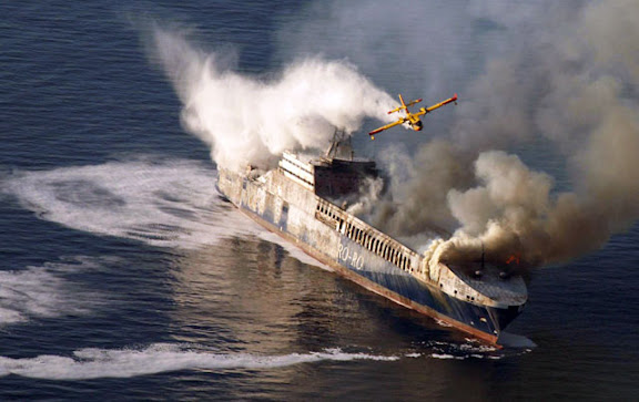
Lloyd's List - Ed Holt - Thursday 7 February 2008
SPECIAL firefighting planes were dispatched off the Croatian coast after a fire broke out on a Turkish trading ship, writes Ed Holt.
The 193 m long Undadriyatik was transporting 200 trucks and 11 tonnes of oil to the Italian port of Trieste when the fire started yesterday morning as the ship was 16 nm off the western Croatian town of Rovinj.
The Greek vessel Ikarus Palace, which was nearby, answered a distress call and all 22 crew members on board and nine others on the vessel were rescued.
The upper deck of the ship had been completely burnt out by yesterday afternoon and authorities said there was a fear of an explosion if the flames reached the oil on board.
It was unclear if the fire had spread to other parts of the ship but rescue officials said they believe the ship is likely to sink.
THE M/F RIVERDANCE
Seatruck Ferries’ Riverdance, which remains aground off Blackpool, lost a further five trailers overboard on Tuesday night when the ship shifted at high water. From first light yesterday, teams worked to remove debris on the starboard side of the ferry to ensure a salvage team could access the ship by rigid inflatable. Pumps are being lifted onto the vessel as the salvors want to correct a 50° list before commencing operations to remove bunkers.
FROM HOLLAND AND KNIGHTCasino boat blown about by Hurricane Katrina still not a vessel
In an unpublished decision, the US Court of Appeals for the Fifth Circuit ruled that a permanently-moored casino boat is not a vessel. In the instant case, the casino boat, floating in a marina in Biloxi, Mississippi, was moored to six steel dolphins using heavy “H” beams and received water and electricity from land-based sources. During Hurricane Katrina, the casino boat was ripped from its moorings, carried several thousand feet through flood waters and over a highway, and crashed into a hotel. The owner of the casino boat filed suit, seeking exoneration from or limitation of liability under the Shipowners’ Limitation of Liability Act. The hotel owner filed a counterclaim, seeking recovery of damages. The court held that a watercraft that has been permanently moored is not capable of being used in for maritime transport and, thus, is not a vessel for purposes of federal admiralty jurisdiction. Petitioner’s argument that the casino boat was “in navigation” when it struck the hotel was found to be unavailing. In the Matter of Silver Slipper Casino Venture LLC, No. 07-60330 (5th Cir., January 31, 2008).
UK – salvage begins for stranded ro-ro ferry
The UK Maritime and Coastguard Agency (MCA) issued a press notice stating that salvage has commenced on the ro-ro ferry that stranded near Blackpool. No pollution has been reported. A second press notice states that salvage gear is being placed on the ferry. (2/6/08).
Without fanfare, the US Coast Guard posted the insightful analysis of the agency’s Marine Safety Program undertaken by VADM James C. Card, USCG (ret). The major recommendations of this report are to increase the emphasis of the program within the Coast Guard, while improving interaction with the marine industry. The agency also released a one-page Marine Safety Overview, providing an indication of how it intends to achieve these goals. Related background material includes Admiral Thad Allen’s Address to the Washington, DC Propeller Club on September 19, 2007 and a Marine Safety Plan of September 25, 2007. The Coast Guard has now formally recognized that its recent relationship with the marine industry was in disrepair and can be expected to move forward with all deliberate speed to address the various issues. The agency is counting on the many segments of the marine industry to renew and enhance this long-standing and vital partnership. (2/8/08).
NOTES FROM THE BRIDGE
Maritime Affairs responds to captains' cry
Thursday February 07 2008
by Akedia Christopher
Director of Maritime Affairs McClean Hobson has thrown down a gauntlet to captains to introduce an alternative measure which they think would be more feasible to account for travelling passengers.
This came after captains expressed their disapproval in the new initiative in which passengers would be required to give their names when travelling on the ferries without having to produce photo identification.
He said if they have any information to help the process, they should contact the Maritime Department
FROM THE INTERNATIONAL DESK
by Arthur Rabjohn CEM
GLOBAL: Tipping Points Could Come This Century
The tipping points include the collapse of the Indian summer monsoon. A number of key components of the earth's climate system could pass their 'tipping point' this century, according to new research led by a scientist at the University of East Anglia. Published by the prestigious international journal Proceedings of the National Academy of Science (PNAS), the researchers have coined a new term, 'tipping elements', to describe those components of the climate system that are at risk of passing a tipping point. The term 'tipping point' is used to describe a critical threshold at which a small change in human activity can have large, long-term consequences for the Earth's climate system.
BOLIVIA; Severe flooding caused by weeks of heavy rain have left 48 people dead and some 40,000 families homeless. Two rivers in the Beni province have broken their banks. A state of emergency has been declared. Among the worst-hit areas are the eastern provinces of Beni and Santa Cruz as well as Cochabamba in central Bolivia. Several thousand people have been moved from areas at risk in Beni, where the River Mamore has broken its banks.
CHILE: Llaima volcano is erupting, prompting the evacuation of some tourists. Columns of ash and smoke rose from the crater up to 5,000m above the volcano that is located 700km south of the capital Santiago. If its activity increases, authorities will need to take evacuate the residents.
MOZAMBIQUE: Thousands of people have been evacuated from the Zambezi river valley, as Zambia would release water from the Kariba dam. The water is expected to flow down the Zambezi into areas of Mozambique already struggling to cope with high flood waters. In Mozambique there are already 100,000 evacuees and the reception centres are full to capacity. Another 40,000 will be evacuated. Mozambican authorities have managed well the crisis so far, but the pressure from the continuing rainfall is putting immense strain on the already overstretched resources.
From Gilbert Sebenste, Staff Meteorologist, Northern Illinois University
Illinois and Wisconsin Snow Totals
Stay dry and have a GREAT Weekend!
RS


![[Valid RSS]](valid-rss.png "Validate my RSS feed")