JAKARTA] The Indian Ocean could be due another massive earthquake within the next 30 years — one that could rival the magnitude of the one that caused the Indian Ocean tsunami in 2004.
Researchers made the prediction after studying corals, which show rings of growth from which past sea levels can be inferred. Earthquakes push the land up, depressing the sea level in the area and preventing corals from growing upwards. Sea levels then rise as the land subsides, leaving the history of the earthquake imprinted in the coral growth patterns.
The scientists analysed coral growth over the last 700 years in the shallow reefs along the 700-kilometre 'Sunda megathrust' fault — a boundary between tectonic plates off the Mentawai islands in western Sumatra, Indonesia.
This section of the Sunda fault had been inactive for at least 50 years until a magnitude 8.4 earthquake in September 2007. Using the coral data the scientists found three previous sets of large earthquakes. If the cycles continue to be consistent — beginning every 200 years — the next earthquake is due within the next few decades.
Danny H. Natawidjaja, an author of the paper and a senior researcher at the Research Center for Geotechnology of the Indonesian Institute of Sciences, told SciDev.Net the probability of a large earthquake in western Sumatra in the next 30 years is more than 70 per cent. MORE
Los Angeles - It's working! On November 13, 2008 more than 5.47 million people in southern California participated in The Great Southern California ShakeOut, now officially the largest earthquake drill in the Nation's history - and according to some community leaders, a success that should be practiced every year.
"This is the best single effort in emergency preparedness in my nearly 20 years in the business," wrote Mike Martinet, Executive Director, South Bay Office of Disaster Management (Area G). "I hope that we can continue to use this scenario or some variations thereof for years to come." The Great Southern California ShakeOut was a week of events, including the drill, all based on the 7.8 Magnitude San Andreas Fault earthquake scenario.
All the resources, tools and information are still readily available at http://www.shakeout.org/. Much of the concept and organization came out of the Earthquake Country Alliance, a public-private partnership, which includes the US Geological Survey, Southern California Earthquake Center, California Office of Emergency Services, Caltech, State Farm, City of Los Angeles, Art Center College of Design, and many other partners.
When organizers of The ShakeOut concluded the historic week of earthquake preparedness events, including millions taking part in the "Drop, Cover, and Hold On" drill, they convened a meeting of emergency managers and community leaders to examine value of the effort. When asked what could be done better, the participants overwhelmingly supported the idea of turning it into an annual day or week of disaster preparedness activities.
"We didn't know when we set out to do this, if anyone would participate," said Lucy Jones, Chief Scientist of the USGS Multi-Hazards Demonstration Project. "They did, and we're now getting calls to do something annually."
The requests to continue the effort have been so constant over the past month that the Earthquake Country Alliance has agreed to look into expanding into a statewide organization. "We certainly have heard many ideas of how we can get more people involved - and we'd like to do just that!" said Mark Benthien, Executive Director of the Earthquake Country Alliance and Outreach Director for the Southern California Earthquake Center. "We hope that an annual ShakeOut-like drill will be part of an expanded statewide earthquake awareness program for many years." MORE
About 90 per cent of world trade is facilitated through seas and oceans. The case of Nigeria is not exceptional. However, incessant pirate attacks have constituted major threat to the country’s maritime trade and investment. Shipwrecks and abandoned vessels on the nation’s territorial waters have been identified as another risk to huge maritime investments.
Gboyega Akinsanmi writes Nigeria’s waters are replete with all manners of obstacles that threaten maritime investment. Aside from incessant pirate cases, her territorial waters are clogged and littered with shipwrecks and abandoned vessels. There was little or no effort geared at clearing the country’s waterways and maritime routes to ensure free movement of vessels and safe investment in the entire area.This, according to experts, has a lot of implications for maritime investment and trade.
It hinders free movement of vessels with potential to cause ship mishap, thus leading to loss of lives, cargoes and multi-billion investments. If continued, it portends unsafe and unsecured maritime routes against the best practice, and Nigeria will definitely so much incur loss in revenue.Also, shipwrecks on Nigeria’s waters provide hideouts for criminals in the country. For instance, abandoned vessels have constituted base for pirates, sea robbers and miscreants to attack legitimate vessel operators and fishing trawlers. This has threatened vessels, maritime trade and investment worth of several billions of dollars. Fishing trawlers have lost about N25 billion to piracy and sea robberies.
The clog on Nigeria’s maritime routes and waterways is increasing concerns and fears of investment in the maritime sector. Like other maritime actors and stakeholders, the management of Nigerdock Nigeria Plc expressed profound worries about heaps of shipwrecks and abandoned vessels on the maritime routes and waterways because they provide hideouts for pirates and sea robbers. MORE
The Global Ice Center has been collecting and monitoring global sea ice data, including ice concentration, ice thickness and ice drift, since its opening in July 2008, in order to provide unified global sea ice information to shipping companies.
The Global Ice Center’s information covers such data as sea ice concentration, thickness and drift over not only the Arctic Sea, but also the Baltic Sea, the Sea of Okhotsk and the Gulf of Saint Lawrence.
Recently, sea ice data from the Global Ice Center was utilized for a successful and safe voyage through the Baltic Sea by an LNG tanker operated by one of the world’s major shipping companies.
In the near future, we will provide historical sea ice data, such as the first day of freezing, the first day of melting, the average rate and the largest amount of sea ice area.
Weathernews believes that our official Global Ice Center website is able to support many shipping vessels across the world, in order to contribute to the safe passage of the vessels that brave the icy waters of the Arctic Ocean.
[Major Characteristics of the Global Ice Center]
AnalysisThe Global Ice Center provides analysis information of sea ice conditions in all affected regions, using data from our original observation network and from organizations of various countries.
ForecastThe Global Ice Center original “I-SEE” model predicts sea ice concentration, thickness and movement out to two weeks, to support safe ship operation.
NetworkThe Global Ice Center, by using innovative technology in academia applied to sea ice data, is able to provide vital information to maritime companies, as well as feedback from ship reports.
Weathernews Inc. is the world's largest private weather service company headquartered in Japan. It is the only global weather content maker that employs over 600 staff (including more than 200 meteorologists) in offices in 32 cities in 16 countries and regions, including United States, United Kingdom, Germany, Netherlands, Italy, France, Spain, Australia, China, Japan, Korea, Malaysia, India, Nepal and Taiwan.
A boating couple from the Coromandel Peninsula who were singled out by a freak of nature on the first day of their holiday have not been put off the lifestyle.
Anne Louden and her husband John were watching an electrical storm last night from their anchorage off Great Barrier Island, when the sky became dark. Just as they went below deck, a water spout picked up their nine metre launch, threw it into the air and dumped it back down. The couple suffered only a few cuts and bruises.
Ms Louden says she has seen disasters on TV and could not imagine ever being part of such an event.
"It's just one of those weird, freaky things that happens. You can't be put off boating, you really can't, it's a spectacular lifestyle. But it gives you an appreciation of weather and caution." Ms Louden says none of the other 30 or so boats in the bay were touched.
Waterspouts occur when layers of high, cool air blow over a body of water such as a lake, river or ocean sweeping up moist air from below.
The UK's sea safety body has warned that computerised navigation systems are steering large vessels into dangerous shallows because officers have insufficient training in their use.
The Department for Transport's Marine Accident Investigation Branch (MAIB) sounded the alert after over-reliance on an incorrectly used Electronic Chart Display Information System (ECDIS) resulted in the temporary grounding of the cargo ship Performer on Harborough Sand on its way to Grimsby in May 2008.
A subsequent investigation by MAIB warned: "The use of ECDIS has steadily increased in recent years, and it is disturbing that the number of accidents resulting from the incorrect use of ECDIS and ECS [Electronic Chart Systems] through poor system knowledge has also risen.
"ECDIS will soon replace paper charts as the primary planning and monitoring media onboard most vessels, but the system can only realise its potential benefits to maritime safety if all mariners who are expected to use the equipment at sea are properly trained."
Many ships' officers, including the master of Performer, were only formally trained in the use of paper charts, although many have used electronic aids. An ECDIS installed in 2007 was Performer's primary means of navigation, but none of her bridge watchkeeping officers had been trained in its use.
MAIB cited a number of accidents in recent years in which misuse of ECDIS or ECS has been a contributing factor, including a cross-Channel ferry that headed for shallows in 2004 without its ECDIS issuing a warning because it had not been correctly set up.
And in January last year a vessel hit a submerged wreck near Dover, severely damaging her propellers, because the wreck was not shown on the ECS display. "The need for mandatory training in ECDIS is compelling," said the MAIB report.
Proposed international regulations require ECDIS in most large new passenger vessels and large cargo boats and tankers, and its retro-fit over time to existing vessels.
ScienceDaily (Jan. 14, 2009) — The water level in the Great Lakes has varied by only about two meters during the last century, helping them to play a vital role in the region's shipping, fishing, recreation and power generation industries.
But new evidence by scientists from the University of Rhode Island and colleagues in the U.S. and Canada, published recently in the journal Eos, indicates that the water level in the lake system is highly sensitive to climate changes.
"In the distant past, there were great fluctuations in the water level of the Great Lakes, but it was thought to have been related entirely to the advance and retreat of the glaciers," said URI geological oceanographer John King, who led the study with URI visiting scientist Michael Lewis, emeritus scientist with the Geological Survey of Canada. "But the last time lake levels fell dramatically – down to 20 meters below the basin overflow outlets – it was due to dry climate conditions."
That event, which occurred between 7900 and 7500 years ago in the early Holocene period, caused the lakes to become disconnected as their overflow rivers, including the Niagara River, ran dry.
"People used to say that the oceans are so big, we can dump whatever we want in them and nothing will happen," said King. "They thought of the Great Lakes in the same way, that the system is too large to be sensitive to climate variations. But now we know that to be untrue. We've demonstrated that at least once in the last 10,000 years, climate drove the lake levels down pretty substantially."
Researchers had long assumed that the Great Lakes had been "hydrologically open" and connected since their formation 16,000 years ago during the retreat of the last ice sheet, but recent evidence has found this to be false. Ancient shorelines, submerged beaches, and tree stumps on the floor of some lakes indicate that the water line had been as much as 20 meters below the present lake level."We had a multi-proxy approach to this study, and through many lines of evidence we identified this as a dry interval with a climactic cause as opposed to a glacial-related cause," King said.
The climate and water levels in the Great Lakes region are determined by the interplay of three air masses: dry, cold Arctic air from the North, dry warm Pacific air from the West, and warm, moist tropical air from the Gulf of Mexico. The scientists found that during the period when lake levels receded significantly, the dry air from the Arctic and Pacific was dominant. Later, when precipitation from the tropical air mass became more frequent, the Great Lakes began to flow from one to another as they do today.
King worries about the economic impact to the Great Lakes region if the present climate changes lower water levels significantly. Navigation, water usage and hydropower would be severely affected.
"The climate interval that occurred back then is different from what we're going through now," King said. "It would take a pretty big change to close the basins again. But the sorts of temperatures and precipitation amounts that happened then are within the range of what is predicted for 2100. In the worst-case scenarios, a lot of things become possible.
"The range of lake-level changes that are likely to happen in the next 100 years is probably larger than the range of levels observed during the last century," he added.
Using a 218-year-long temperature record from a Bermuda brain coral, researchers at the Woods Hole Oceanographic Institution (WHOI) have created the first marine-based reconstruction showing the long-term behavior of one of the most important drivers of climate fluctuations in the North Atlantic.
The North Atlantic Oscillation (NAO) is a wide-ranging pressure seesaw that drives winter climate over much of North America, Europe and North Africa. Past reconstructions of the NAO have relied mainly on terrestrial, or land-based records, such as tree ring chronologies combined with ice cores and historical climate data. Those records do not fully capture oceanic processes linked to NAO variability, and short instrumental records from relatively few locations limit the understanding of ocean-atmosphere dynamics with regard to NAO behavior.
"By analyzing the coral, we were able to look at changes in the ocean relative to changes on land," said Nathalie Goodkin, lead author of the study published in the December issue of the journal Nature Geoscience. "Because they are slow growing and have long life-spans, corals can provide high resolution records that are well dated and centuries long."
As they grow, corals accrete seasonal and annual growth layers, similar to tree rings. The proportions of trace elements versus the major element (calcium) found in the layers of the skeleton largely depend on the temperature of the seawater in which it was formed. By analyzing the strontium to calcium ratio in the Bermuda brain coral, Goodkin and colleagues - WHOI scientists Konrad Hughen, Scott Doney and William Curry - were able to reconstruct monthly changes in ocean temperatures and evaluate variability of the NAO during both cold and warm periods from the Little Ice Age (1800�) to modern day.
The research team found the variability of the NAO decade-to-decade (multi-decadal scale) has been larger, swinging more wildly, during the late twentieth century than in the early 1800s, suggesting that variability is linked to the mean temperature of the Northern Hemisphere. This confirms variability previously reported in past terrestrial reconstructions.
"When the Industrial Revolution begins and atmospheric temperature becomes warmer, the NAO takes on a much stronger pattern in longer-term behavior," said Goodkin. "That was suspected before in the instrumental records, but this is the first time it has been documented in records from both the ocean and the atmosphere."
The recent heavy frost will no doubt return again and again over the winter and early spring. Here is some advice for safer driving in severe weather:
* Drivers are reminded that rain and spray can reduce visibility and when the road is wet it can take up to twice as long to stop, so it makes sense to slow down when it's raining.
* Surface water may affect motorways and major A roads so we advise drivers to move slowly through any standing water and test their brakes once they're through before continuing to drive.
* High-sided vehicles are particularly affected by windy weather but strong gusts can also blow any vehicle, cyclist, motorcyclist, or horse rider off course. This can happen on open stretches of road exposed to strong crosswinds, or when passing bridges and high-sided vehicles.
* Plan journeys. Check the weather forecast, road conditions, and the route for delays before leaving home and delay travelling if the weather becomes severe.
* Drivers are also advised to carry warm clothing and an emergency pack, which includes food and water, boots, de-icer, a torch, a spade if snow is forecast, and to make sure they have plenty of fuel for the journey.
Retired port executive Ron Brinson said the Charleston maritime community should take the rapt attention that Maersk’s decision to leave has thrust on the port and turn it into a better understanding of the industry.
“The public does not understand and does not appreciate the value of the port,” Brinson said Thursday to a crowded room at the Charleston Motor Carriers Association’s monthly luncheon at the Sheraton in North Charleston.
Because of that misunderstanding, Brinson said, “we have a port that has been competing with one hand tied behind its back.”
Brinson, now living in Charleston, retired from the business in 2003 after more than 15 years as president and CEO of the Port of New Orleans. A former newspaper editor and reporter in Charleston, Brinson also worked for the S.C. State Ports Authority before leaving for Louisiana.
Much of Brinson’s talk focused on the fallout caused by Maersk Line’s announcement that it would begin pulling services out of Charleston early this year and completely leave town when its contract expires at the end of 2010.
Although the Danish company’s business is extremely important to Charleston and the entire state, the community should not take the news personally, Brinson said.
“These are unemotional business decisions that we sometimes tend to make emotional,” Brinson said.
Charleston, he noted, isn’t the first community to deal with the loss of Maersk, the world’s largest steamship line and the S.C. State Ports Authority’s largest customer.
In 1999, Maersk left the Port of Long Beach in California because officials there could not or would not agree to concessions the shipping company said it needed.
It took about three years, but Long Beach recovered after losing 25% of its business to competitor Los Angeles.
Brinson also warned the group not to heap blame on the International Longshoremen’s Association. Anti-union sentiment seems to have grown stronger nationally in the wake of Detroit’s struggles, he said, and seems even more intense in Southern states, including South Carolina.
The Maersk decision also compounded those feelings because the company said it was moving because the ILA refused to let the company operate from the common-user yard at the Wando Welch Terminal, a move that would have eliminated several dozen union jobs.
People, especially in South Carolina, tend to perceive unions as a four-letter word, he said. “The reality is that unions are a four-letter word at our port, and that word is F-A-C-T.”
In Charleston, he said, union labor has a good reputation. The SPA has a good reputation also, he said, and offered this advice: “Ease up; give the ports authority a little breathing room.”
He had some advice for port executives as well. Brinson said they should be willing to try new operating models and not wait for changes — potentially misguided changes — to be forced upon the port by the General Assembly and governor.
And he suggested that the entire maritime community, including SPA staff members, spend time “rebooting” relationships with the public. If the state is giving off the perception that it does not support its port operations, steamship lines might take the cue and send their business elsewhere.
“Maybe we South Carolinians are sending the wrong message to the marketplace,” he said.
The year 2008 tied with 2001 as the eighth warmest year on record for the Earth, based on the combined average of worldwide land and ocean surface temperatures through December, according to a preliminary analysis by NOAA’s National Climatic Data Center in Asheville, N.C.
For December alone, the month also ranked as the eighth warmest globally, for the combined land and ocean surface temperature. The assessment is based on records dating back to 1880.
The analyses in NCDC’s global reports are based on preliminary data, which are subject to revision. Additional quality control is applied to the data when late reports are received several weeks after the end of the month and as increased scientific methods improve NCDC’s processing algorithms.
NCDC’s ranking of 2008 as the eighth warmest year compares to a ranking of ninth warmest based on an analysis by NASA’s Goddard Institute for Space Studies.
The NOAA and NASA analyses differ slightly in methodology, but both use data from NOAA's National Climatic Data Center – the federal government's official source for climate data.
Global Temperature Highlights – 2008
The combined global land and ocean surface temperature from January-December was 0.88 degree F (0.49 degree C) above the 20th Century average of 57.0 degrees F (13.9 degrees C). Since 1880, the annual combined global land and ocean surface temperature has increased at a rate of 0.09 degree F (0.05 degree C) per decade. This rate has increased to 0.29 degree F (0.16 degree C) per decade over the past 30 years.
Separately, the global land surface temperature for 2008, through December, was sixth warmest, with an average temperature 1.46 degrees F (0.81 degree C) above the 20th Century average of 47.3 degrees F (8.5 degrees C).
Also separately, the global ocean surface temperature for 2008, through December, was 0.67 degree F (0.37 degree C) above the 20th Century average of 60.9 degrees F (16.1 degrees C) and ranked tenth warmest.
Global Temperature Highlights – December 2008
The December combined global land and ocean surface temperature was 0.86 degree F (0.48 degree C) above the 20th Century average of 54.0 degrees F (12.2 degrees C).
Separately, the December 2008 global land surface temperature was 1.22 degrees F (0.68 degree C) above the 20th Century average of 38.7 degrees F (3.7 degrees C) and ranked 14th warmest.
For December, the global ocean surface temperature was 0.74 degree F (0.41 degree C) above the 20th Century average of 60.4 degrees F (15.7 degrees C) and tied with December 2001 and December 2005 as sixth warmest.
Other Global Highlights for 2008
The United States recorded a preliminary total of 1,690 tornadoes during 2008, which is well above the 10-year average of 1,270 and ranks as the second highest annual total since reliable records began in 1953. The high number of tornado-related fatalities during the first half of the year made 2008 the 10th deadliest with a 2008 total of 125 deaths.
Northern Hemisphere snow cover extent in December was 16.95 million square miles (43.91 million square kilometers). This was 0.17 million square miles (0.43 million square kilometers) above the 1966-2008 December average. Northern Hemisphere snow cover extent was below average for most of 2008.
Arctic sea ice extent in 2008 reached its second lowest melt season extent on record in September. The minimum of 1.80 million square miles (4.67 million square kilometers) was 0.80 million square miles (2.09 million square kilometers) below the 1979-2000 average minimum extent.
NOAA understands and predicts changes in the Earth's environment, from the depths of the ocean to the surface of the sun, and conserves and manages our coastal and marine resources.
Gloucester - The following letter was sent on Jan. 9 to Rear Admiral Dale Gabel, First Coast Guard District, Boston:
Dear Rear Admiral Gable,
We are writing to seek your assistance with an urgent request regarding the recent tragic loss of the Gloucester fishing vessel Patriot. In the wake of this incident, which claimed the lives of experienced fishermen Matteo Russo and Giovanni Orlando, thorough answers to many questions are necessary.
We are award that the Coast Guard has initiated an investigation into this incident, and that the First District and Sector Boston personnel are continuing to examine available information regarding all of the factors involved in the loss of the Patriot. We urge you to maintain and intensify this effort, and to expedite it as much as possible.
Yet we firmly believe that the information surrounding the loss must be significantly expanded to include the position, condition and all other pertinent facts available from examination of the Patriot in its present position. We thus request, in the strongest possible terms, that the Coast Guard undertake an underwater investigation of the vessel as soon as possible, utilizing either professional divers and/or submersible vehicles.
We are aware that this request is extraordinary, but yet this incident is as well. Thorough answers, to the extent possible must be developed to the haunting questions that remain.
Among those questions are how a sound vessel, with an experienced crew could so suddenly be lost in the sea and weather state that existed on Jan. 1 and 2. Understanding what led to the loss of the Patriot and Matteo Russo and Giovanni Orlando is critical, and conducting a subsurface investigation will yield answers that are vital for investigators, other Coast Guard personnel, the families of those who have been lost, those who must return to sea as fishermen, and the public.
Accordingly, please initiate such an investigation as soon as it may be undertaken. Thank you for your consideration of this request, and please do not hesitate to contact us if we may be of any further assistance, or to discuss this matter further.
Sincerely State Sen. Bruce Tarr State Rep. Ann-Margaret Ferrante Mayor Carolyn Kirk
HONOLULU — The U.S. Coast Guard warns boaters and beach goers to exercise caution in all Hawaiian waters for the next few days due to potentially high winds and coastal area flooding. The Coast Guard reminds all who work and play in island waters that conditions may be more dangerous during potentially high surf conditions.
In addition, marinas and boaters are reminded to check that boats in port are properly secured, bilge pumps are functional, and all loose items are removed from decks. Report any boats adrift, pollution or other maritime emergencies to the Coast Guard Sector Honolulu Command Center at 808-842-2600 or to the National Response Center at 800-424-8802.
The National Weather Service — www.noaa.gov — has posted hazardous weather outlooks for the entire state of Hawaii to include gale force wind warnings, small craft advisories and high surf advisories. The boating public is strongly encouraged to pay close attention to local weather forecasts before leaving port.
Here are some tips for those who choose to go out on the water during the potentially heavy weather:
Leave a float plan with a responsible individual who knows your intentions, location and who they should call if you do not return as scheduled.
Wear a Coast Guard-approved life jacket and set the example for your passengers or paddling partners.
Carry a marine band VHF radio and/or other reliable means of communication.
Be prepared for the shock of sudden immersion and the disabling effects of cold water. Plan for the worst: dress as though you are going to get wet and be cold.
Maintain awareness on the water — be aware of activity around your vessel including changing weather, and always know your location.
Be responsible — know that alcohol and drugs cause accidents and sometimes death.
Don’t boat alone — boating alone is not recommended. Recreational paddlers canoeists and kayakers often travel with a single craft and one partner, or even solo, but it is recommended you canoe, kayak or boat with at least three people or two craft.
Know your limitations paddle — be honest with yourself and your companions. Your life and the lives of those in your party may depend on how everyone understands each other’s capabilities.
Maritime New Zealand (MNZ), the branch of government responsible for marine safety, would be responsible for rescuing the rower, Oliver Hicks, in case of an accident. MNZ believes that an accident is almost inevitable because of the harsh conditions on the Southern Ocean. Hicks will be using a boat that is powered by rowing but has cabins in which he can sleep, prepare food, and store supplies.
The boat is also allegedly designed to withstand Southern Ocean conditions.MNZ has great reason to be skeptical of Hicks' plans, however.
Previous attempts have resulted in accidents requiring rescue, and in one case an adventurer drowned. Rescue missions are costly and put rescuers themselves in danger. Hicks' journey would take him 500 days and would cover 24,000 square kilometers, or just under 15,000 miles.
Australian officials are hardly excited about the project, but unlike their New Zealand counterparts cannot stop him from leaving. If he needs rescuing, MNZ will still be on the hook.
Hicks has already accomplished some impressive feats of solo rowing - he is the only person to have rowed from America to the United Kingdom alone - and feels confident that he is capable of completing his mission and staying safe.This incident underscores the need for special tourism policies for Antarctica.
The human desire to undertake difficult and dangerous adventures is admirable, but is disregarding the wishes of those who would have to rescue you also admirable? It's not as if MNZ could just ignore Hicks in the event of an accident, even if he wanted them to do so. It seems a shame that governments are hamstrung in this way.
While this type of tourism doesn't represent the kind of environmental threat that we at ASOC are most concerned about, it does point to the overall lack of regulation for Antarctic tourism that would protect both people and the environment.
Laws and rules no doubt deaden the souls of expeditioners, but they keep people safe and prevent unnecessary crises.
Posted by Antarctic and Southern Ocean Coalition at 7:31 AM
Record flooding of the Stillaguamish River filled low-lying areas south of the Stanwood city limits, leaving Marine Drive under more than 3 feet of water last week.
“It was close,” said Stanwood Camano Fire and Rescue (SCFR) Chief Mike Ganz Friday morning. “We are finally out of the woods.”
River gauges showed the Stillaguamish to be at or near record depth by 6 p.m. Thursday. An emergency earthen wall along SR 532 held back the cresting flood, and with the cooperation of Burlington Northern Santa Fe (BNSF), the city sandbagged the tracks and Marine Drive to keep east Stanwood dry.
By Thursday evening, the governor’s office had declared a state of emergency for most of Snohomish County.
On Friday morning, it seemed as if the worst had passed.
After consultation with BNSF officials, tracks were reopened by 10 a.m. On Monday, Fort Freberg, a 7-foot-tall emergency dike named for retired firefighter Jack Freberg, still stands as a reminder of the Herculean effort that saved the city.
Mike Simmons, SCFR emergency manager, said he is in no hurry to remove the fortification. “You really don’t want to pull these things down too quickly,” said Simmons. Ganz credits the volunteers who worked alongside city and emergency crews.
“These folks — they’re awesome,” he said. “They did a fantastic job.”
According to Ganz, many different agencies and individuals — some from other counties — worked hand-in-hand to prevent a tragedy.
In addition, inmate work crews from Monroe Correctional Complex worked with city crews filling sandbags and providing them to residents.
U.S. Army Corps of Engineers worked alongside city and county crews to shore up temporary protective dikes and repair levees.
“They helped plug a break near 95th Avenue NW,” said Ganz. Rebecca Hover, Snohomish County Sheriff’s Office public information officer, said rescue teams were deployed swiftly to prevent the loss of life.
“We responded to dozens of calls, but it’s impossible to say how many calls we went on or how many people we rescued — there’s really no way to keep count,” said Hover. “Rescuers would get a call to go to one house to help people out and then they’d find more people who needed help out of the area or neighborhood.”
Most of the calls involved people needing help out of their houses or businesses; they also helped people who got stuck in their vehicles as they tried to drive through the flood waters, she said.
Christian Davis, North County Fire/EMS public information officer, said their crews were kept busy with rescue operations.
“We had nine water rescue calls, with 14 victims removed from the flooded areas,” said Davis. “We (also) assisted with a sandbagging request by DEM (Department of Emergency Management) for the city of Stanwood.”
One unique moment, said Davis, was when a 100-gallon propane tank washed up on the shore in the Warm Beach area.
Crews secured the tank, stopped the leak and notified a company for its removal, he said. Stanwood’s emergency operations center went into action Wednesday morning and remained open until 4 p.m. Friday.
“The final damage estimates haven’t come in yet,” said Simmons. “Within the city limits, it will probably be very low.”
Most of the real damage happened to homes and farms south of Stanwood, he said. For many, the days and weeks ahead will mean clean-up and salvage operations. Claims for assistance should be started immediately, said Simmons. Only damage from the floods occurring on or after Jan. 6 should be reported.
“The primary focus now is to compile damage reports from Snohomish County residents and businesses to qualify for federal disaster aid and speed relief to our citizens,” he said.
“Do not wait for a professional estimate of cost or an insurance adjustor document to fill these forms out.”
Receding water has allowed for the reopening of Marine Drive, but several streets remained navigable only by boat at NEWS deadline.
Dianne White, Stanwood mayor, said she is filled with pride after witnessing the ‘flood fight’ play out.
“The flood was an event that showcased the quality of the citizens of Stanwood,” she said. The seamless response of emergency crews and the scope of volunteerism prevented disaster on a wider scale, she said.
“Without the help of the Army Corps of Engineers, we would have lost our waste water treatment plant,” said White.
Flood waters entered offices at the plant, though damages are reported as minimal. Water processing and quality were not affected.
“The fire department’s Support 99 group as well as the Salvation Army worked tirelessly to meet the needs of victims, volunteers and EOC workers throughout the event,” she said. White applauded the efforts of Red Cross volunteers, Stanwood/Camano School District personnel and staff from Josephine care facility whose residents were evacuated to Stanwood High School.
“What distinguishes Stanwood is the ‘can do’ attitude of our citizens and businesses,” said White. “We had over 400 sandbag volunteers, who filled bags at Index Sensors and Twin City Foods parking lots.”
White said she is grateful for food provided to volunteers by QFC, the family of Carolyn Lund, and numerous citizens.
Flood gates erected to help drain the flood performed better than expected. On Friday, the gates were draining at 1,500 cubic feet per second and lowered the flood water by 46 inches in one day.
“This new addition to our flood fighting arsenal is serving to get Marine Drive and the railroad tracks open much sooner than past years,” she said. “The Stillaguamish Flood District and Max Albert are to be commended for their persistence in getting this structure built.”
Chuck Hazleton, Stillaguamish Flood Control District commissioner, said he was overwhelmed by the success of the flood control gates in operation near Marine Drive.
“The flood gates are working better than we had expected,” said Hazelton. “The velocity of the discharge is more than we anticipated.”
Built in September 2007, the control system — a concrete structure — has 10 gates to create a nonporous channel back into the river.
The overall project cost $175,000, and the city subsidized $30,000 towards the construction of the gated system.
“It was definitely money well spent,” said Hazelton.
Sen. Mary Margaret Haugen (D), of Camano Island, said the legacy of this flood event will be how residents saved their city.
“One of the merits of living in a small community is how your neighbors reach out to help,” said Haugen. “I am so proud of the way people in the Stanwood area rallied to help each other.”
Haugen said she believes Stanwood was spared because of all the people who helped. “It's really tragic how many people in our state were affected,” she said. “You just can't imagine how bad this is until you've experienced it.”
The flooding was yet another blow to a region already hit hard by bad weather, said Haugen.
PHILADELPHIA - The Coast Guard Captain of the Port Sector Delaware Bay in Philadelphia has set ice condition three Thursday and is warning mariners to be aware of ice in the Delaware Bay and River.
Ice condition three is set when weather conditions are favorable for the formation of ice in navigable waters. All masters, ship agents, and owners and operators of all vessels, marine facilities and marinas should review and adhere to the seasonal ice procedures listed below. These criteria were developed in partnership with the Mariners’ Advisory Committee for the Delaware Bay and River. Ship agents should generally act as liaison between the Coast Guard and their vessels.
When ice is present, but less than two inches, vessels must have a propulsion system with a minimum of 1000 horsepower, and be able to maneuver un-assisted through the ice without needing to stop, back off and ram the ice.
When ice is present in the C and D canal, only steel-hulled vessels whose propulsion systems are in excess of 1000 horsepower may transit the canal.
Vessel convoys will not be directed for ice or ice build of less than two inches, provided vessels can maintain headway. For ice conditions of two inches or greater, the Captain of the Port, in conjunction with the MAC, will consider implementing a plan that includes directing vessel convoys.
Vessel moorings should be checked frequently to ensure the vessel is adequately moored.
Vessels at anchor should maintain their engines on standby at all times.
Vessels at anchor should ensure that proper bridge watches are stood at all times.
Vessel sea chests should be checked regularly for ice buildup and precautions should be taken to ensure that the sea chests are kept clear.
The Captain of the Port Sector Delaware Bay may establish additional requirements for specific geographic areas of the Captain of the Port Zone if conditions warrant such restrictions.
Please refer to the Sector Delaware Bay website for additional information regarding ice operations within the Sector Delaware Bay zone at http://www.uscg.mil/d5/sectDelawarebay or by calling our Sector Delaware Bay ice line at (215)-271-4995.
If you have any questions regarding the contents of this bulletin or the expectations of the Captain of the Port, please contact the Waterways Management staff at (215) 271-4889 or the Situational Unit Controller at (215) 271-4807.
ScienceDaily (Jan. 15, 2009) — The job of one University of Missouri researcher could chill to the bone, but his research could make weather predicting more accurate.
Patrick Market, associate professor of atmospheric science in the College of Agriculture, Food and Natural Resources, is chasing storms in the dead of winter in order to release weather balloons that will produce data about the little-known phenomenon of thundersnow.
"One of the things we don't understand is how the cloud becomes electrified," Market said. "We hope to determine how the atmosphere is becoming unstable."
Market and his storm-chasing students are searching for winter storms in order to release weather balloons into the storm every 90 minutes over a 24-hour period. The balloons carry boxes with a barometer to measure pressure, a thermometer to measure temperature, and a hydrometer to measure humidity.
Market uses a GPS to monitor wind speed and direction of the balloons. This information covers the five things that are most important for a meteorologist to know for accurate predictions, according to Market.
"It has been decades since a detailed study with modern weather balloons has been done to see how the atmosphere destabilizes for summer thunderstorms, much less the winter storms," Market said. "So we are taking this tried-and-true tool of the meteorology trade and applying it to the very specific instance of heavy snowfall in the winter."
Once the weather balloons are launched, they provide detailed readings of every layer of the atmosphere. More detailed readings and data provide better and more accurate forecasting."We get thunderstorms in all seasons. That means something is making the atmosphere unstable," Market said. "Thunderstorms are often associated with heavy rainfall or heavy snowfall. It's just as important to get it right in the spring, summer or winter."
The phenomenon known as thundersnow is not understood very well. It is defined as a snowstorm with thunder and lightning that can bring heavy snowfalls of 8 to 12 inches. Tracking such storms can be quite a challenge.
"Often, these winter storms cause us to travel through inclement weather in order to get to the area where the weather balloons should be launched," Market said. "During travel, the heater in the vehicle cannot be on because the instruments need to be kept cold."
Freetown — Acting director of disaster management department in the office of national security (ONS) has said in Freetown that disasters amount to greater percentage of the causes of death of the world's population.
John V. Rogers told participants at the opening ceremony of the training of trainers' clinic on disaster risk reduction for schools that though they cannot stop disasters from happening yet they can with their knowledge on disaster risk reduction and early warning signals.
"Man's negative interaction with his environment has often produced harmful effects with devastating consequences on human existence," he said.
Rogers said this sad chapter can only be reversed through learning and implementation of best practices as demonstrated in other areas of the world.
"Some of the disaster related incidences in Sierra Leone are due to illiteracy and ignorance. It has often been stated that a well informed public is a protected one," he said.
He said it has been the ardent desire of government to enhance the capacity of teachers that have played tremendous role in the disaster management school outreach programmes in the country.
The acting director noted that children were among the most vulnerable population group during a disaster especially those attending school at the time of the crisis. "Therefore learning about disaster risk reduction in schools can put teachers and children in a better position to play important role in saving lives and protecting members of the community in time of disaster."
He added that the clinic would provide the necessary tools to teachers and students in educational institutions to prepared, mitigate and respond to disasters.
On behalf of the national security coordinator, ONS chief of staff Larry Bassie said increase number of gravity of disaster with grave consequences that undermines the survival and dignity of livelihood in communities was a concern.
Story by Petty Officer 3rd Class Melissa Hauck(ALAMEDA, Calif.) -- The Coast Guard and other emergency personnel who respond to distress calls will soon see an improvement in their ability to locate people during search and rescue cases.
This improvement centers around an emergency position indicating radio beacon (EPIRB), a device that when activated can act as a virtual lifeline from people in distress to rescue crews by sending out a transmitted signal via air, sea or land.On Feb.1, 2009 Cospas-Sarsat, an international satellite-based search and rescue (SAR) system established by the U.S., Canada, Russia and France will cease satellite processing of 121.5/243 MHz analog EPIRBs and will begin processing only the 406 MHz digital radio beacon signals, making it illegal to use the obsolete 121.5/243 MHz beacons.
The newest 406 MHz beacons incorporate global positioning system (GPS) receivers that transmit highly accurate positions of distress almost instantly to SAR agencies via the Geostationary Earth Orbit Local User Terminals (GEOSAR) satellites.
The digital frequency has been designated internationally for use only for distress. Other communications and interference, such as on 121.5 MHz analog signals, is not allowed.The change is expected to result in a substantial reduction in wasted SAR resources on false alerts while simultaneously increasing the responsiveness of the system for real distress cases."
The 121.5 MHz analog beacons produce a high incidence of false alarms and a host of other limitations that include poor signal strength, search areas that can be as large as 12 to 15 miles in radius and unreliability," said Petty Officer 2nd Class Craig Mercier, an operations specialist stationed at the District 11 command center on Coast Guard Island here."
The distress signals from the 406 MHz beacon are much more accurate than the analog beacon. Each digital beacon has a unique ID encoded within its signal that can quickly confirm that the distress is real, who they are looking for and where they should look, which will ultimately save lives," he said.When a 406 MHz signal is received, SAR authorities can retrieve information from law-required registration data that includes beacon owner contact information, emergency contact information and identifying characteristics of the vessel."
Digital EPIRBS also provide position accuracy that narrows the vessel's position to less than two miles in radius and decreases the amount of time SAR teams must search. This results in quicker response times, and is a major advantage over the 121.5 MHz beacons," he said.
The decision to stop satellite processing of 121.5 / 243 MHz signals was announced by Cospas-Sarsat nearly two years ago stating problems in the frequency band which overwhelm search and rescue authorities with poor accuracy and numerous false alerts, negatively impacting the effectiveness of lifesaving services.
The Coast Guard strongly recommends mariners obtain the new 406 MHz EBIRB and file a float plan with a friend or family member on land, with an approximate time of return and location prior to getting underway.
EPIRB owners can register their equipment in the U.S. 406 MHz Beacon Registration Database at:http://www.beaconregistration.noaa.gov/ or by calling 1-888-212-SAVE.
Beacon registration is required to be updated with accurate information every two years or when emergency contact or other information changes.
ScienceDaily (Jan. 12, 2009) — NASA and the National Science Foundation have successfully launched and demonstrated a newly designed super pressure balloon prototype that may enable a new era of high-altitude scientific research. The super-pressure balloon ultimately will carry large scientific experiments to the brink of space for 100 days or more.
This seven-million-cubic-foot super-pressure balloon is the largest single-cell, super-pressure, fully-sealed balloon ever flown. When development ends, NASA will have a 22 million-cubic-foot balloon that can carry a one-ton instrument to an altitude of more than 110,000 feet, which is three to four times higher than passenger planes fly.
"This flight test is a very important step forward in building a new capability for scientific ballooning based on sound engineering and operational development," said W. Vernon Jones, senior scientist for suborbital research at NASA Headquarters in Washington. "The team has further work to do to enable the super pressure balloon to lift a one-ton instrument to a float altitude of 110,000 feet, but the team has demonstrated they are on the right path."
Ultra-long duration missions using the super pressure balloon cost considerably less than a satellite and the scientific instruments flown can be retrieved and launched again, making them ideal very-high altitude research platforms.
The test flight was launched Dec. 28, 2008, from McMurdo Station, which is the National Science Foundation's logistics hub in Antarctica. The balloon reached a float altitude of more than 111,000 feet and continues to maintain it in its 11th day of flight. The flight tested the durability and functionality of the scientific balloon's unique pumpkin-shaped design and novel material. The material is a special lightweight polyethylene film, about the thickness of ordinary plastic food wrap.
"Our balloon development team is very proud of the tremendous success of the test flight and is focused on continued development of this new capability to fly balloons for months at a time in support of scientific investigations," said David Pierce, chief of the Balloon Program Office at NASA's Wallops Flight Facility at Wallops Island, Va. "The test flight has demonstrated that 100 day flights of large, heavy payloads is a realistic goal."
In addition to the super pressure test flight, two additional long-duration balloons have been launched from McMurdo during the 2008-2009 campaign. The University of Hawaii Manoa's Antarctic Impulsive Transient Antenna launched Dec. 21, 2008, and is still aloft. Its radio telescope is searching for indirect evidence of extremely high-energy neutrino particles possibly coming from outside our Milky Way galaxy.
The University of Maryland's Cosmic Ray Energetics and Mass, or CREAM IV, experiment launched Dec. 19, 2008, and landed Jan. 6, 2009. The CREAM investigation was used to directly measure high energy cosmic-ray particles arriving at Earth after originating from distant supernova explosions elsewhere in the Milky Way galaxy.
The super-pressure balloon was highlighted in the National Research Council's decadal survey "Astronomy and Astrophysics in the New Millennium," and will play an important role in providing inexpensive access to the near-space environment for science and technology.
NASA and the National Science Foundation conduct an annual scientific balloon campaign during the Antarctic summer. The National Science Foundation manages the U.S. Antarctic Program and provides logistic support for all U.S. scientific operations in Antarctica.
The Wallops Flight Facility is a division of NASA's Goddard Space Flight Center in Greenbelt, Md. Wallops manages NASA's scientific balloon program for the Science Mission Directorate. Launch operations are conducted by the Columbia Scientific Balloon Facility of Palestine, Texas, which is managed for NASA by the Physical Science Laboratory of New Mexico State University in Las Cruces.
A concrete dome capable of withstanding 300-mile-an-hour tornadoes is sure to become a landmark around the small Webster County town of Niangua, Webster County's emergency management director said of a project that will make major progress today.
A heavy plastic membrane that will act as a mold for concrete shot onto steel reinforcing bar will be inflated today, Emergency Management Director Bill Sexton said.
The dome will be the first monolithic dome approved for use by the Federal Emergency Management Agency for use as a tornado shelter, Sexton said.
The 61-foot-wide dome also can shelter students of the nearby Niangua School and other people, with a maximum capacity of 400.
Ninety percent of the structure's $311,000 cost is being financed by FEMA.
Rural Winona County residents will be better alerted in case of flood or tornado after county crews install 10 new sirens paid for by a $242,000 state grant.County commissioners earlier this month accepted the grant, which will pay to buy and install the sirens as early as this spring. The new sirens will alert residents to floods or tornadoes in areas that previously didn’t have sirens or are covered by aging sirens, County Emergency Management Director Bob Bilder said.
Officials in Stockton and Minnesota City said sirens there didn’t go off during a tornado warning in 2008, and Stockton leaders bought a new siren for their city last year.The new sirens won’t rely on electricity in an emergency: they’re solar-powered with battery backups, Bilder said.
New sirens are slated to be installed in the following locations:
Twin Bluffs near Pickwick on County Road 7 near the Gunderson subdivision in Goodview Dresbach Elba Minnesota City Green Terrace Mobile Estates near La Moille In the mobile home park in Stockton Near the Springbrook Addition on County Road 17, And in the Hidden Valley Mobile Home Park.
County leaders still are trying to obtain funds to install six more new sirens, said Dave Belz, an emergency grants contractor for the county.Those locations are in Homer, Cedar Valley, Dakota, the Sunny Acres subdivision in Goodview, Minneiska and Whitewater State Park.
WHEN THE GOING GETS ROUGH, CHEF Choi goes beyond his comfort zone — he makes hot, steaming soup.
“It’s the most difficult thing to do in the galley of a ship caught up in big waves or some storm, and it’s SOP not to prepare soup during such times, but I have realized that it’s the best comfort food to whip up for my officers and crew,” confides the game 27-year-old chief cook of an international shipping lines.
His usual standbys are borsch, a traditional spicy Russian concoction made of beetroot, and eintofp, a German broth where all kinds of sausages and meats and beans broil in savory delectation.
And he makes these soups every now and then when his ship crosses, say, the Mediterranean Sea and the treacherous Indian Ocean. The video he took of one Indian Ocean crossing shows his ship heaving and dipping and facing head-on waves as impossibly tall as churches.
But Chef Choi—full name: Ian Jul Banghal, of Cagayan de Oro City—waves off these stomach-churning moments, saying, “What I keep in mind are our destinations.” He rattles off: Palma de Mallorca or Party Island in Spain; Marseilles, France; Salerno and Palermo, Italy; Rotterdam, the Netherlands; Hamburg, Germany; Swansea and Liverpool, UK; Istanbul, Turkey; Antwerp, Belgium, and even picturesque Chennai, the third largest city in India.“Once,” he chuckles, “we snaked through the Suez Canal in Egypt for the longest time. We also docked at the mythical island of Thessalonike in Greece, and I explored its nooks and crannies. For spooky kicks, nothing can beat our adventure at Constanza in Romania, home of Dracula. Then there were those memorable safari trips in Kenya and Tanzania. And the time I saw the breathtaking lay of the land from a mountaintop in the Croatian city of Split. But my favorite outing of all was our stop at the Seychelles Island. It’s paradise.
Paradise and hellish waves spice up Chef Choi’s thrilling ride through life.
When he graduated from the prestigious Liceo de Cagayan High School in Cagayan de Oro in 1998, he wanted to do three things in college: study architecture, major in voice and pursue stage acting. At the time, however, there were not many college opportunities for these artsy things in the city. So his parents, Juliano, a CPA, and Agustina, a businesswoman, sent him to the nearest possible school for such inclinations—the University of Mindanao in Davao City, where he took up BS Architecture.
Upon graduation, he worked for Comfac Corp., a multinational firm engaged in designing and producing furniture and fixtures. He was the interior designer and estimator. (“I designed the products and made the budget and production estimates.”)
Growing up in the kitchen
It paid well and allowed him to continue his involvement with Pasundayag, a community theater group in Cagayan de Oro. He got to do a successful Valentine’s concert with his sister Julie Ann in a hotel ballroom.
But he was also into cooking and baking. His mother ran a thriving restaurant and catering business, and he continued to help out when he could. He was known for treating his friends to wondrous culinary adventures.
One friend happened to mention to him that there was a scholarship for aspiring chefs. The successful applicants would be flown to a culinary school in Germany for a one-year course. Even better, the graduates of that course would be automatically offered jobs in an international shipping line —as chefs traveling around the world on the high seas.
He applied for the scholarship. During the interview, he was told, “You don’t belong here. You have no professional experience in the kitchen.”
Nonplussed by such putdowns—his theater background apparently prepared him for these dramatic moments—he replied, “While it’s true that I’m an architect by profession, I grew up in the kitchen. Food is my passion. It’s my life. All this I bring with me wherever you’ll take me. And I’m a very good student. Teach me.”
He got the scholarship.
Lessons in Germany
During the six-month preparatory training in General Santos City and in Manila, he surprised even himself by topping the class. “My classmates were professional chefs and they knew everything, but I was a newcomer and I wanted to learn everything,” he says now, leafing through his certificates and photographs.
In Germany, he had a grand time savoring the hands-on lessons in the kitchen. “Our teachers were European chefs, and they shared their professional secrets. They were very exacting. But they were also very helpful. My enthusiasm and diligence endeared me to them. I absorbed everything, not just the kitchen tricks, their ways of seeing and preparing and presenting—but also the culture, their way of thinking. I learned a lot.”
Chef Choi began his new career as a second cook in a freighter that carried container vans to ports all over Europe. It was a brave, new world for him. “It was not so much work as fun because I got to see the world for the first time,” he beams.
He had no trouble adjusting to life in the ship either. “In theater,” he says, “I learned how to deal with all sorts of personalities and egos in such a way that I could work with anyone well so the show could go on. I applied this mind set in the ship, and I was able to navigate through the various nationalities and their cultural quirks.”
In no time at all, he was promoted chief cook. It was then that he decided he was not going back to architecture.
“Food and travel—these are my life now,” Chef Choi declares.
With the whole world as his stage, guess what is Chef Choi’s most prized souvenir from all his travels. What would you know, but a certificate attesting that he has sailed across the Equator.
“This was not even in my dreams,” he lets out.
“This is like magic. Suddenly I’m doing all this. The world is no longer out there. It’s here. And I’m traipsing about it like crazy.”
Thar she blows: A weather report from the world’s windiest ocean locale
A buoy anchored southeast of Greenland dutifully gathered wave and weather data in one of the world’s most hostile environments for more than five months, until the really rough weather of winter arrived and the buoy snapped free — but not before it confirmed satellite data suggesting the region is the world’s windiest for oceans.
The seas east of Greenland’s southern tip, a desolate point called Cape Farewell, are notoriously storm-tossed, says Ian Renfrew, an atmospheric scientist at the University of East Anglia in Norwich, England. As storm systems race eastward from northernmost Canada, their frigid winds either pass over Greenland’s kilometers-thick ice sheet and gain speed as they rush down its eastern slope, or they spill around the southern tip of the island. Waters in the area are likewise buffeted by storm systems that approach the island from the east and are then steered southward by Greenland’s icy blockade.
The region’s bad weather is what spurred Renfrew and his colleagues to tether a weather buoy to the 3-kilometer–deep seafloor there in the summer of 2004. At least 10 times that summer and fall, and sometimes for extended intervals, instruments on the floating platform measured winds exceeding speeds of 20 meters per second (about 45 miles per hour), the researchers reported January 13 at the annual meeting of the American Meteorological Society in Phoenix. Then on December 7, after less than six months in service, either high winds or huge waves — or both — pummeled the buoy and broke its tether.
Satellite-based sensors supplied data in recent years indicating that the ocean region east of Cape Farewell is the windiest in the world, says Renfrew. Furthermore, he notes, the buoy’s measurements suggest that the wind speeds inferred from the satellite data are accurate — a calibration that’s useful for analyzing similar data gathered for other parts of the ocean. Renfrew and his colleagues estimate that 20 percent of the time winds at the site east of Cape Farewell blow even faster than 20 meters per second.
Rain machines: Tropical cyclones supply bulk of rain for some places
Tropical cyclones, the immense rotating storm systems that include hurricanes and their weaker cousins, typically last only a short time and cover a relatively small part of Earth’s surface. Nevertheless, at some latitudes these storms provide a substantial part of the region’s rainfall, a new study suggests.
For each year from 1998 through 2007, meteorologists tallied between 90 and 100 tropical cyclones that had peak wind speeds of at least 17.5 meters per second (about 39 miles per hour), says Christopher L. Williams, a recent graduate of Georgia Tech in Atlanta. Using satellite data, he and colleague Frank Marks Jr. of NOAA’s Hurricane Research Division in Miami estimated total worldwide rainfall for those years, as well as the amount of precipitation dumped only by the tropical cyclones.
Overall, tropical cyclones drop between 2 and 3 percent of the world’s rainfall, the researchers reported January 13 at the annual meeting of the American Meteorological Society in Phoenix. And that fraction is particularly small at latitudes near the equator, where rainfall is plentiful but the forces that drive large-scale atmospheric rotation and cause cyclones to develop are practically nonexistent, says Williams.
However, at latitudes between 15° and 30° — a swath that in the Northern Hemisphere stretches from central Honduras to just north of New Orleans — rainfall is less abundant, and tropical cyclones account for as much as 17 percent of annual rainfall.
ScienceDaily (Jan. 12, 2009) — A NASA-funded study describes how extreme solar eruptions could have severe consequences for communications, power grids and other technology on Earth.
The National Academy of Sciences in Washington conducted the study.
The resulting report provides some of the first clear economic data that effectively quantifies today's risk of extreme conditions in space driven by magnetic activity on the sun and disturbances in the near-Earth environment. Instances of extreme space weather are rare and are categorized with other natural hazards that have a low frequency but high consequences.
"Obviously, the sun is Earth's life blood," said Richard Fisher, director of the Heliophysics division at NASA Headquarters in Washington.
"To mitigate possible public safety issues, it is vital that we better understand extreme space weather events caused by the sun's activity."
Besides emitting a continuous stream of plasma called the solar wind, the sun periodically releases billions of tons of matter called coronal mass ejections.
These immense clouds of material, when directed toward Earth, can cause large magnetic storms in the magnetosphere and upper atmosphere. Such space weather can affect the performance and reliability of space-borne and ground-based technological systems.
Space weather can produce solar storm electromagnetic fields that induce extreme currents in wires, disrupting power lines, causing wide-spread blackouts and affecting communication cables that support the Internet. Severe space weather also produces solar energetic particles and the dislocation of the Earth's radiation belts, which can damage satellites used for commercial communications, global positioning and weather forecasting. Space weather has been recognized as causing problems with new technology since the invention of the telegraph in the 19th century.
A catastrophic failure of commercial and government infrastructure in space and on the ground can be mitigated through raising public awareness, improving vulnerable infrastructure and developing advanced forecasting capabilities. Without preventive actions or plans, the trend of increased dependency on modern space-weather sensitive assets could make society more vulnerable in the future.
NASA requested the study to assess the potential damage from significant space weather during the next 20 years. National and international experts from industry, government and academia participated in the study. The report documents the possibility of a space weather event that has societal effects and causes damage similar to natural disasters on Earth.
"From a public policy perspective, it is quite significant that we have begun the extremely challenging task of assessing space weather impacts in a quantitative way," said Daniel Baker, professor and director of the Laboratory for Atmospheric and Space Physics at the University of Colorado in Boulder. Baker chaired the panel that prepared the report.
"Whether it is terrestrial catastrophes or extreme space weather incidents, the results can be devastating to modern societies that depend in a myriad of ways on advanced technological systems," said Baker. "We were delighted that NASA helped support bringing together dozens of world experts from industry and government to share their experiences and begin planning of improved public policy strategies."
The sun is currently near the minimum of its 11-year activity cycle. It is expected that solar storms will increase in frequency and intensity toward the next solar maximum, expected to occur around 2012.
The Heliophysics Division of NASA's Science Mission Directorate in Washington provided funding for the study. The division seeks to understand the sun, its solar processes and the interaction of solar plasma and radiation with Earth, other planets and the universe.
Understanding the connections between the sun and its planets will allow better prediction on the impacts of solar activity on humans, technological systems and even the presence of life itself in the universe.
The National Academies are chartered by Congress to provide independent technical and scientific advice to the federal government.
ScienceDaily (Dec. 23, 2008) — Satellites that were designed to measure sea level over the world's oceans can serve a valuable purpose over land, a new study has found. Researchers used NASA's TOPEX/Poseidon satellite and the European Space Agency's ENVISAT satellite to measure the height and extent of flooding in North America, South America, and Asia.
The study shows that satellites can supplement the measurements that the United States Geological Survey (USGS) gathers from flood gauges on the ground -- at little or no cost, said C.K. Shum, professor of earth sciences at Ohio State University.
"After a flood, we can look back at the satellite data to pinpoint when the flood began, and find out how far the flood waters extended, which is really important for flood modeling," he said.
Satellites such as TOPEX/Poseidon measure the height of land or water by bouncing radio signals off of surfaces and measuring how long the signals take to return.
Rough surfaces scatter some of the signal in other directions, and cause errors in a satellite's on board tracking system. This often happens over land. Scientists use "re-tracking" software to fix the errors, and make the satellite's measurements more precise.
That's what the Ohio State software does -- it re-tracks the satellite data, but in a way that enables detailed measurements of water on land.
The key to the software is an algorithm that can tell the difference between water and snow cover. Ohio State postdoctoral researcher Hyongki Lee developed the algorithm and graduate student Manman Zhang applied the algorithm for her doctoral thesis.
Zhang presented the work in a poster session at the American Geophysical Union meeting in San Francisco.
Shum, Zhang, and their colleagues used the software to process TOPEX/Poseidon data from the 1997 Red River flood in the upper Midwest of the United States, an area with abundant farmland and wetlands. They detected flooded regions within four river basins: the Red River Basin in North Dakota and Minnesota; the Missouri River Basin in North Dakota and South Dakota; and the Minnesota River Basin and the Mississippi River Basin, both in Minnesota and Iowa.
The flood happened in April of that year, as winter snows began to melt. Zhang's algorithm differentiated between the scattered radar signal produced by water and by areas still covered by snow. As the floodwaters began to move down the Red River, the satellite measurements provided estimates of flood levels.
After re-tracking, the satellite data agreed with USGS ground measurements taken at the time. For example, the software determined that flood waters in Grand Forks, North Dakota, rose 20 feet (6 meters), which matched data recorded from flood gauges there.
The researchers did the same for the June 2008 Iowa City flood that killed three people and damaged 2 million acres of farmland. They found that they could track the ebb and flow of that flood over a scale of several hours. For that part of the study, they worked with Carrie Huitger, a USGS hydrologist who supplied the flood gauge data. They performed similar studies with TOPEX/Poseidon data for a flood in the Amazon River Basin, and with ENVISAT data for a flood in southwestern Taiwan -- both with similar results.
The satellites can't be used to forecast a flood because the data isn't processed very quickly and the spatial coverage of the satellite measurements is limited, Shum explained. Even preliminary processing takes hours. But after a flood, such data can add to data collected on the ground, to help scientists better understand how floods happen.
Next, the researchers want to automate the software so that it can build an archive of flood data. Since the satellites are already in orbit collecting the data, there would be little cost beyond building the database and enabling scientists to access it.
In the future, a new satellite may enable more extensive and detailed measurements. Ohio State scientists lead an international team that has proposed the Surface Water Ocean Topography (SWOT) mission. The SWOT satellite will feature dual antennas that will gather high-resolution data over a much wider surface of the earth than is possible with today's satellites.
Collaborators on this project include Doug Alsdorf, associate professor of earth sciences, and Frank Schwartz, professor and Ohio Eminent Scholar in Hydrogeology.
This work was funded by the National Science Foundation and NASA.
The crew of a Devon rescue boat is sending out its own SOS to get its vessel reinstated. A petition of 5,000 signatures is being handed in to parliament on Wednesday, saying lives are being put at risk.
The story made headlines last summer when the crew used the boat to rescue a teenage girl at Hope Cove.
The Maritime and Coastguard Agency (MCA), which had warned the crew that the boat was unsafe, impounded it. The MCA is due to hold talks on the issue.
The MCA later brought the boat back, with a restriction that it could be used within a certain distance from the beach in the South Hams area of Devon.
But two months ago the boat was locked away again, this time until a consultation was carried out.
The crew has said the boat is safe and fears lives are being put at risk. MP Anthony Steen said: "The rescue boat had been successfully operated by four men who were able to launch the boat at a moment's notice in the event of an emergency since they worked locally.
"Now a large stretch of the south Devon coastline is suddenly without adequate sea rescue coverage."
The MCA said Hope Cove was covered by the nearby Salcombe lifeboat. It said in a statement: "We will be consulting with stakeholders soon to discuss beach safety provision in the South Hams."
Singapore – comments sought re draft amendments to MARPOL Annex I The Singapore Maritime and Port Authority (MPA) issued a circular stating that it is seeking comments from owners, operators, masters, and others regarding draft interim guidelines and draft amendments to MARPOL Annex I adopted by the recent session of the IMO Marine Environment Protection Committee (MEPC). The draft documents relate to: (1) the method of calculation of the energy efficiency design index for new ships; (2) the Supplement to the IOPP Certificate; (3) prevention of pollution during transfer of oil cargo between oil tankers at sea; (4) amendments to Regulations 1, 12, 13, 17, and 38; (5) the IOPP Certificate; and (6) the Oil Record Book. The draft amendments are expected to be adopted at the next session of the MEPC, scheduled for July 2009. Shipping Circular No. 5 of 2009 (1/6/09).
UK – report on container ship-fishing vessel collision The UK Marine Accident Investigation Branch (MAIB) issued the summary of its preliminary examination of a collision between a container ship and a fishing vessel that occurred in good weather off Lizard Point on 18 September 2008. Visibility from the bridge of the container ship was impaired. Neither vessel was maintaining a good lookout or making proper use of their radar. (1/6/09).
UK – contract awarded for MSC NAPOLI wreck removal The UK Maritime and Coastguard Agency (MCA) issued a press notice stating that a contract has been awarded for removal of the stern section of the wreck of the MSC NAPOLI. The scrap is to be delivered to a recovery facility in the Netherlands. (1/6/09).
NOAA is proud to announce the Buffalo Bills as the first National Football League team to become a StormReady® Supporter. With this designation the Bills are better prepared for severe weather and to make fans and spectators at Ralph Wilson Stadium aware of such events.
To achieve this status, the Bills organization met rigorous guidelines, which include developing severe weather safety plans, actively promoting severe weather safety through awareness activities and conducting safety training.
“The StormReady Supporter program was designed to help non-government organizations improve communications and safety skills needed to save lives while strengthening partnerships with NOAA's National Weather Service and local emergency management,” said Mickey Brown, deputy director of the National Weather Service Eastern Region. “The Buffalo Bills really scored a touchdown by being the first National Football League team in the country to be a StormReady® Supporter and creating a safer environment for all Buffalo Bill fans.”
StormReady® Supporter is a component of the nationwide StormReady® preparedness program that helps communities develop severe weather and flooding response plans with NOAA's National Weather Service and local emergency managers. Since the StormReady® program began in 1999, more than 1,300 U.S. communities have become StormReady®. Buffalo Bills' Ralph Wilson Stadium.
“The Buffalo Bills are honored to be the first NFL team to achieve the StormReady® status,” said Joe Frandina, vice president of stadium operations for the Bills. “We feel this is another important step in making our stadium as safe as possible for our fans.”
The StormReady® program is part of NOAA National Weather Service's working partnership with the International Association of Emergency Managers and the National Emergency Management Association. NOAA understands and predicts changes in the Earth's environment, from the depths of the ocean to the surface of the sun, and conserves and manages our coastal and marine resources
SEATTLE - The American Red Cross is reminding people not to overlook the emotional aspect of recovery after the devastating floods.
The Red Cross says disasters are upsetting experiences for everyone involved, but children, senior citizens, people with disabilities and people for whom English is not their first language are especially at risk. Some elderly people may seem disoriented at first and children may be afraid. "When disaster strikes, a child's view of the world as a safe and predictable place is temporarily lost," said Lyle O'Neel, Red Cross disaster mental health worker. "Children become afraid that the event will happen again. How a parent or other adult reacts to a child following any traumatic event can help children recover more quickly and more completely."
The Red Cross says it’s important to let children and elderly people know that they are safe and that you will help them find a safe place to stay.
Some basic steps you can take:
- Try to return to as many of your personal and family routines as possible. - Get rest and drink plenty of water. - Limit your exposure to the sights and sounds of disaster, especially on television, the radio and in the newspapers. - Focus on the positive. - Recognize your own feelings. - Reach out and accept help from others. - Do something you enjoy. Do something as a family that you have all enjoyed in the past. - Stay connected with your family and/or other support systems. - Realize that recovery can take time.
Take care of your pets
If you have pets, try to find and comfort them. A scared animal may react by biting or scratching. Handle animals carefully and calmly. Pets can become upset and react in unusual ways, such as spraying urine, defecating on floors or scratching/biting furnishings. Since pets will need regular care and attention to help them calm down, try to leave pets with a family member, friend, veterinarian or boarding facility while you are cleaning up your home. Animals are naturally inquisitive and could get injured if they are brought back to a damaged home.
- Use toys, a blanket or favorite human's unsoiled clothing to comfort pets. - Make sure pets are fed their usual diet, and have plenty of water. - Visit your pets regularly, speak calmly and take some time out to play with them. Doing so can help you in your recovery, as well.
How you can help
To help residents who have been affected by the Washington State flooding please go to http://www.seattleredcross.org/show.aspx?mi=4861 to make a secure online donation or call 1-800-REDCROSS. Checks can be made payable to the American Red Cross Serving King & Kitsap Counties, P.O. Box 3097, Seattle, WA 98114.
WASHINGTON, Jan. 13 (UPI) -- The U.S. Coast Guard says that it is not shirking rescues at sea despite a government report that found it was spending more effort on homeland security tasks.
The inspector general for the Department of Homeland Security said in a report issued last week that there had been "clear trend toward emphasizing homeland security missions" that could make it more difficult for the Coast Guard to carry out its traditional safety roles.
USA Today said Tuesday that Coast Guard commanders saw the conclusions as misleading and that its boats and aircraft still spend plenty of time on non-homeland security tasks.
"Our priority has always been and will continue to be saving lives," Coast Guard spokesman Lt. Cmdr. Christopher O'Neil told the newspaper.
A major finding of the disputed report was a decrease in the number of rescue operations from around 84,000 in 2001 to 60,000 in 2007 at a time the Coast Guard's ranks were growing. The report also noted the Coast Guard was spending more time patrolling U.S. fishing waters and intercepting boatloads of illegal immigrants.
From Holland and Knight
DHS OIG – review of USCG mission performance
The Department of Homeland Security (DHS) Office of Inspector General (OIG) issued it annual review of the US Coast Guard’s mission performance for fiscal year 2007. The report shows that performance is largely unchanged from the previous year. The agency met six of its eleven performance targets, the same as 2006. Non-homeland security mission resource hours decreased, while homeland security mission resource hours increased. OIG-09-13(1/9/09).
My name is Jay Cafasso and I am a retired hazardous mateials specialist and corporate executive. I am also a NWS advanced storm spotter. Robin Storm seeks to educate the public regarding severe weather as well as scientifically intercept and observe severe storm.
We chase safely to intercept and observe storms and report our observation to the local NWS/WFO so they can keep you better informed.
Remember, safety first always!
The purpose of this site is to educate the public on the topics of 'severe weather" and its effects on the "maritime service". Articles are drawn from a variety of sources both government and private and re posted in partial or full text. Article credit is linked or posted.
The information contained on this site is for educational purposes only and is not intended for any particular person and or circumstance nor for profit.
The author of this site makes no express warranties or guarantees.

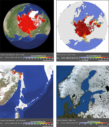


![[Valid RSS]](valid-rss.png "Validate my RSS feed")