 Storm's direction could change over the next few days
 BY KEN KAYE
South Florida Sun-Sentinel
August 16, 2008
Don't exhale just yet, South Florida.Although newly minted Tropical Storm Fay appears headed for the state's west coast, the projected path — and its ultimate intensity — remain in question, the National Hurricane Center in Miami-Dade County said.
As it is, the storm's forecast track puts the entire state in the cone of uncertainty and the system could pass close enough to this region to produce wind gusts of up to 70 mph and heavy rain Monday and Tuesday, forecasters said.
"We'll be on the right side of the system, so we could see some of the feeder bands," said meteorologist Barry Baxter of the National Weather Service in Miami.
On Friday evening, Fay was over the Dominican Republic about 750 miles southeast of Miami, moving west at 14 mph with sustained winds of about 45 mph.
Forecasters and emergency managers urged residents to remain alert over the weekend, saying the tropical system could take a surprise turn in this direction.
"There's a lot of uncertainty in the models," said Corey Walton, a hurricane center meteorologist. "South Florida residents should stay updated."
South Florida schools still were expecting Friday to start classes Monday. To check in Palm Beach County, parents can call 561-357-7500; in Broward, 754-321-0321.
No matter what Fay brings, emergency managers said now is a good time to ensure all hurricane preparations have been completed.
Chuck Lanza, Broward County emergency management director, urged residents to amass enough food and water to last 72 hours, fuel up vehicles and stock up on enough medications to last a week.
"It's just another reminder that we have the potential for hurricanes throughout the season," he said.
It is possible that Fay, the sixth named storm of the 2008 Atlantic hurricane season, will intensify into a hurricane before it reaches Florida, forecasters said.
However, it was expected to plow over the Dominican Republic, Haiti and Cuba, which could weaken it. For now, the hurricane center predicts it will be a tropical storm when it approaches the Keys on Monday and Florida's southwest coast Tuesday.
Because the system threatened to produce up to 12 inches of rain along its path, government officials issued tropical storm watches and warnings throughout the northeastern Caribbean and the southern Bahamas.
Fay already has proved to be unpredictable. Forecasters as early as Wednesday thought it might grow into a tropical depression. Even though it moved into a favorable environment for development over the Atlantic, it remained a mushy blob of clouds and low pressure near the Leeward Islands and Puerto Rico the past three days.
It didn't achieve a closed surface circulation until its center moved inland over the east coast of the Dominican Republic on Friday afternoon. Forecasters found the winds were strong enough to designate it a tropical storm, bypassing the customary first step of deeming it a tropical depression.
FROM THE NATIONAL HURRICANE CENTER
- NHC issuing advisories on TS FAY
- Podcast audio briefings regarding Fay will be issued periodically
- Access hurricane advisories on your mobile phone: www.nhc.noaa.gov/mobile....(learn more)
| Eastern Pacific | Atlantic |
|
WEATHER NOTE
New weather alert device can help during hurricanes
TAMPA BAY, FL -- With hurricane season upon us, an innovative and reliable weather radio is on the market. If you lose contact with a family member during a storm, these two-way communication systems will allow you to stay in touch.
The latest technology combines two-way communication with NOAA weather alerts from the National Weather Service. An emergency alert siren transmits warnings while also allowing you to signal warnings to others. Plus an LED flashlight is attached in the event of power outages.
These emergency radios have a twenty mile range along with with hands-free operation and a mini-USB port for charging in the car or from your PC. Models are available from Motorola and other companies in many retail outlets.
MARITIME NOTE
Unmanned weather ship on Olympic duty
| |
 |
| Weather detection ship Meteorology 1 |
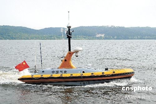
Weather detection ship Meteorology 1 was built by Shenyang Aerospace Xinguang Corporation. It is the first unmanned detection ship to be built in China. The ship is currently stationed in Qingdao, where it is providing weather forecasting services for the Olympic sailing competition.
Meteorology 1 was the result of collaboration between Shenyang Xinguang Corporation and China Astronomic Bureau’s Atmosphere Detection Technology Center. The system is composed of the boat itself and a land-based control system.
The ship is self-righting and can survive in heavy seas. It has a powerful engine that can propel it for several hundred kilometers, and the vessel can spend 20 days at sea without requiring maintenance. As well as weather detection, the ship can be used to detect accidents and environmental incidents at sea, as well as acting as a disaster warning system.
Meteorology 1 is just 6.5 meters long, and the whole ship is made of carbon fiber. It is crammed with high technology, such as intelligent navigation, radar, satellite positioning systems, photo processing and transmission.
Meteorology 1 can keep statistics on wind speed, wind direction, temperature, humidity and marine surface temperature. The unmanned ship can also check visibility at sea, which is of particular significance during Olympic sailing bouts.
America and Israel have spent around 10 years researching unmanned ship technology, while China is just starting out. Shenyang Aerospace Xinguang Corporation started work on unmanned meteorology systems in 2003. The company says it has already solved many key technical issues regarding the navigation of unmanned vessels.
RS


















![Validate my RSS feed [Valid RSS]](valid-rss.png)