 SURVIVING THE BIGGEST WAVE EVER
Ketchikan, Alaska - Alaska is a land of geological superlatives: Big mountains, vast spaces, huge earthquakes.
So it would stand to reason that an event that happened exactly 50 years ago on July 9th is also the largest of its kind ever recorded.
On July 9, 1958, the largest wave in modern history occurred in Lituya Bay, on the northern Southeast Alaska coast about halfway between Cape Spencer and Yakutat.
Initially, the wave - generated by a landslide that itself was generated by a massive earthquake that shook the region for more than a thousand miles up and down the coast - reached a height of more than 1,700 feet. It was still nearly 100 feet high when it reached the mouth of the bay seven miles later.
In its path were three small trolling boats taking advantage of the fact that Lituya Bay was the closest anchorage to the lucrative Fairweather fishing grounds offshore.
In fact, Lituya Bay is the only secure anchorage along more than 100 miles of Gulf of Alaska coast from just north of Cape Spencer to Yakutat. The entrance to Lituya Bay is extremely dangerous, and should only be attempted is short (10 to 20 minute) periods of slack water, according to the United States Coast Pilot book series.
Despite that challenge, the bay is often the refuge of choice when the weather gets bad along the coast.
Interestingly enough, the weather on July 9, 1958 was not the reason that three fishing vessels chose to anchor up in Lituya Bay.
According to one of the surviving fishermen, Howard Ulrich, it was a sunny day and the waters around the mouth of the bay were calm.
"Fishing had been poor on that memorable ninth day of July and I pulled my gear and headed the Edrie for Lituya Bay early in the evening," Ulrich told the Alaska Sportsman Magazine in an article for its October, 1958 issue. "all was smooth.it was a quiet and peaceful anchorage."
Two other boats joined the Edrie inside the bay, that night, the Badger and the Sunmore. But they chose an anchorage on the other side of the bay from the Edrie. When the wave came, two crews would survive and one crew would not.
A History of Big Waves
The unusual geology of Lituya Bay has lent itself to several large waves in the last 150 years.
The seven mile long, two mile wide bay has two large glaciers and several large mountains rising steeply from tidewater. It is only a few miles as the crow flies from tidewater to high mountains like Crillion (12,726 feet) and Fairweather (15,300 feet) making it a popular staging area for climbers. In fact, two groups of Canadian climbers narrowly missed being in the bay the night of July 9th. Had they been camped at tidewater as planned, the wave's death toll would have more than 20 rather than only two.
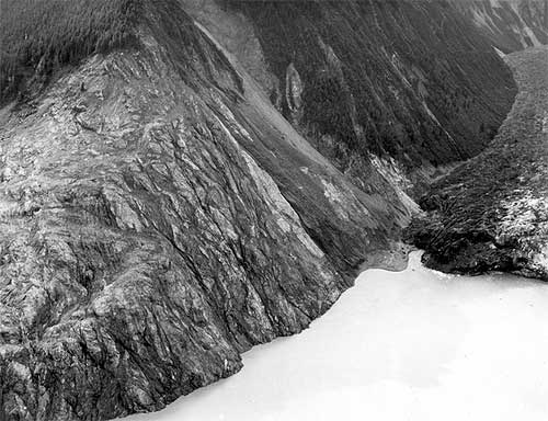
 jpg Trees washed out and turned upslope by water at altitude of 1,720 feet." align="bottom" border="0" height="384" width="500">
Photograph courtesy U.S. Geological Survey
The weather also plays a role in the bay as it gets a large amount of precipitation - mostly rainfall. Some of the inland areas along the coast between Lituya Bay and Yakutat have had more than 300 inches of rain according to the National Weather Service and the winter and spring of 1958 was a wet one throughout Southeast Alaska. The ground in Lituya Bay - which frequently gets up to 150 inches of rain a year - was oversaturated even though it was sunny that July.
The third factor was the massive earthquakes that frequently topped 6 and 7 on Richter Scale in the area.
A final factor was the deep water - up to 800 feet - near the head of the bay. When earthquakes or other events caused landslides, they would displace large amounts of water sending it rushing toward the narrow mouth of the bay and the open ocean.
Federal geologist Don Miller was the foremost expert on Lituya Bay in the 1950s and the early 1960s. In his 1960 report, "Giant Waves in Lituya Bay Alaska." he pointed out evidence of five "giant" waves created primarily by land or glacier slides between 1853 and 1958.
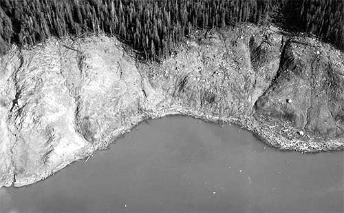
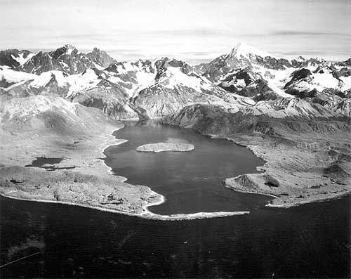 jpg Lituya Bay, 1954, trimlines of the 1936 giant waves and the 1853-54 giant wave" align="bottom" border="0" height="397" width="500">
Photograph courtesy U.S. Geological Survey
The 1853-54 wave was estimated at 395 feet, the 1874 wave at 80 feet, the 1899 wave at 200 feet, the 1936 wave at 490 feet and the 1958 behemoth swept trees off a hillside at more than 1,720 feet.
In addition to those giant waves, the waters of Lituya Bay had also been the site of several other disasters involving both the native Tlingit tribes and groups of American, British and French explorers and adventurers from the 1780s into the Twentieth Century, according to Philip Fradkin in his 2001 book "Wildest Alaska: Journeys of Great Peril in Lituya Bay."
Most of these involved the deadly, narrow entrance that featured tide rips and waters running up to 13 knots in either direction. Most notable was a disaster that cost French explorer Jean-Francois La Perouse more than 20 of his sailors. Fradkin also noted that Tlingit oral tradition featured several stories of "giant" waves and mass drownings in the bay.
Three Boats In the Bay
There were two commonly used anchorages near the mouth of Lituya Bay on that July night in 1958. Ulrich and his eight-year-old son "Sonny" chose to anchor about half a mile in from the mouth on the south side of the bay in place called, appropriately enough "Anchorage Cove."
Two other trolling boats, the Sunmore (with Orville and Mickey Wagner on board) and the Badger (operated by Bill and Vivian Swanson) anchored up on the opposite side of the bay, just behind the nearly mile long spit that extended most of the way across the mouth of the bay. The opening itself was less than 300 yards across and most of that water was too shallow for boats to cross. Some fishermen estimate there may less than 50 feet of open water at times.
The Ulrichs had anchored up just after 8 pm, while the other two boats - running partners who both lived in Juneau - anchored up around 9 pm.
Around 8 pm, a plane took off from near Cenotaph Island (so named after the drowning of the 20 French sailors in 1786). On board were 10 Canadians who had just returned from the first Canadian ascent of Mount Fairweather.
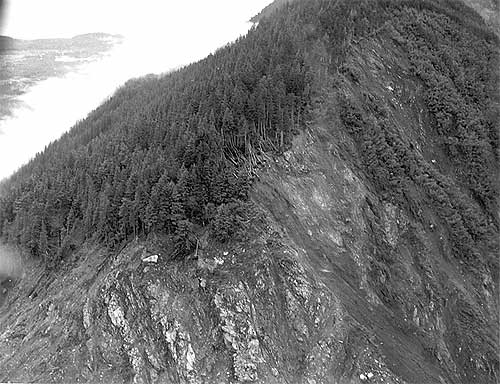
 jpg Stump of living spruce tree broken off by the giant wave at Harbor Point, mouth of Lituya Bay" align="bottom" border="0" height="426" width="500">
Photograph courtesy U.S. Geological Survey
"The expedition was scheduled to leave the following day, but the pilot of their Royal Canadian Air Force amphibian arrived at 6 pm that night and told them to pack immediately," Fradkin wrote in "Wildest Alaska." "He was worried about the possibility of fog and wanted to get the climbers back to Juneau that night. The climbers cursed the pilot's nervousness. They missed dinner in a hurry to pack and departed at 9 pm. Another party of climbers was due that day by boat but they had been delayedHad the two groups proceeded as planned, there would have been a total of 20 climbers camped on the shoreline that night."
Fradkin noted that the Canadian climbers weren't the only living things making a fortuitous getaway from the bay.
"As the Canadian climbers flew away, so did the nervous kittiwakes (that nested on the cliffs of Cenotaph Island)," Fradkin wrote. "The gulls ascended like so much confetti blown upward. The high intensity alarm call of thousands of birds echoed through the still bay. They passed over the Badger and splattered the boat with droppings. Some crashed into the vessel's rigging and plummeted to the deck. The Swansons were frightened."
Up and down the coast as far as Yakutat and Hoonah observers would report similar odd behavior by shore birds and other animals. Then, at approximately 10:16 pm, it happened.
"Cursing Myself For Not Moving Sooner"
The quake was later determined to be 8.3 on the earthquake scale and was centered 45 miles south of Lituya in Cross Sound. It was felt strongly as far south as Seattle and as far north as Anchorage. At Yakutat, 80 miles to the north of Lituya, three people out berry picking died instantly when a small island they were on immediately dropped more than two dozen feet under the water. Later measurements determined that a nearby mountain had risen more than 50 feet at the same time.
Overall, the earth had moved some 21 feet horizontally and 3.5 feet vertically along most of the fault line. While most earthquakes last only a few seconds, the initial length of the quake was later estimated at more than two minutes by Don Miller.
Then Lituya Bay got hit with the other shoe.
Miller - who was in Glacier Bay at the time of quake and flew to Lituya the next day - determined that less than two minutes after the initial tremor, the side of an unnamed 5,616 foot peak on the east side of Gilbert Inlet (at the head of the bay) plunged into the bay. At least 2,000 feet of rock fell.
"The noise was deafening," Fradkin wrote. "The violent impact of forty million cubic yards of rock, ice and coarse soil weighing ninety million tonswas heard 50 miles to the north. Ulrich said it sounded like an explosion."
With the first jolt, Bill Swanson tumbled out of his bunk on the Badger. He later told the Alaska Sportsman that the he could see even the highest mountains shaking. Then he saw the Lituya Glacier appear to literally rise up into the air.
"I know you can't ordinarily see that glacier from where I was anchored," he was quoted in the October, 1958 issue. "People shake their head when I tell them I saw it that night. I can't help it if they don't believe mebut I know what I saw that night."
From his vantage point, he could also see the mountainside slide away and crash towards the water. From his viewpoint on the other side of the bay, Ulrich could see the wave rise up and devastate the forested hillside.
All three boat crews had been woken up by the earthquake. But while the captains of the Badger and Edrie were transfixed by the spectacle at the head of the bay, the Wagners on the Sunmore jumped to immediate action and got their boat headed out of the bay.
It proved to be a fatal decision. Swanson reported seeing the Sunmore just about to turn out into the entrance when it was caught by the wave and flung over Harbor Point across the opening from the end of the spit. All that was found later was an oil slick marking the spot where the boat went down in deep water.
Ulrich told Alaska Sportsman that he was "petrified" by the landslide and the wave and didn't begin to act until he saw the wave, then still some 300 feet high engulf Cenotaph Island some two miles away from his boat.
"I began to move then," he said. "And I moved fast, cursing myself for not moving sooner."
" I Think We've Had It. Goodbye"
He got a life jacket on his son and started the engine. He started to pull the anchor and found it unmovable.
"The wave (then estimated at more than 75 feet high) was almost upon us and we were fastened to the bottom with a heavy chain," Ulrich said. He surmised that the quake had caused the anchor to get tangled on the bottom. He let out all his extra chain, in hopes that it would be enough to allow the boat to ride up and over the wave. Then he turned the boat into the wave and held on.
Photograph courtesy U.S. Geological Survey
"As the Edrie began her almost perpendicular ascent to the crest of the wave, the chain snapped," Ulrich said, adding that he wanted to get a message out so his wife in Pelican would eventually find out her husband and son had died. "There seemed to be no hope for survivalI grabbed the handset of my radiophone and yelled into it: 'Mayday! Mayday! This is the Edrie in in Lituya Bay. All hell has broken loose in hereI think we've had it. Goodbye.' "
But the luck that had abandoned the Wagners was still on Ulrich's side. At the top of wave, he regained enough control of his boat to hold on and steer around the debris being carried by the wave. A few seconds later, the worst had passed.
He sent out another message saying he thought they'd made it through. Immediately, other boats outside Lituya began radioing back. But, Ulrich noted, the silence from the Badger and the Sunmore was ominous.
Just about the time that Bill Swanson saw the wave engulf the Sunmore as it tried to escape, the wave - estimated to be approximately 80 feet high - hit his boat and carried it over the La Chaussee Spit and dumped it stern first into the open ocean.
"We went way over the trees and I looked down on rocks as big as an ordinary house as we crossed the spit," Swanson told the Alaska Sportsman. "We were way up above them. It felt like we were in a tin can and somebody was shaking it."
After the crash landing, the boat immediately began to sink. They were surrounded by acres of wood debris - including a large tree that smashed through the pilot house and broke several of Swanson's ribs - but managed to get into eight foot skiff with only their underclothes on, according to Fradkin's book. At nearly midnight, they were found by the crew of the vessel Lumen which was picking its way through the miles of debris looking for signs of survivors in the pitch dark.
After surviving the giant Lituya wave, Ulrich continued to fish but then quit the business a year later. As recently as 2004, he was still reliving the events of July 9, 1958. He wrote a brief story that appeared in Esquire magazine about that night under the title "What it Feels Like to Survive a Tsunami."
The Swansons eventually got a replacement boat, but Vivian - whose hair reportedly turned gray overnight after the Lituya incident - refused to go fishing with Bill again, according to Fradkin.
On the night of May 26, 1962. Bill Swanson returned to Lituya Bay for the first time since the wave in 1958. Shortly after passing through the narrow entrance to the bay, he suffered a massive heart attack and died.
WEATHER NOTE
LATEST ON FAY

Web makes it easy for stormchasers to track weather
ROBERT NOLIN
In ancient times, before the Internet ruled the world, folks needed pencil, straightedge and a rudimentary knowledge of latitude and longitude to track a storm like the wannabe tropical depression now knocking at the Caribbean's door.
No longer.
Now all an amateur storm chaser needs is a keyboard and mouse. In recent years, meteorological-based Web sites, including that of the U.S. government's own National Hurricane Center, have become sophisticated enough to drench even the most demanding weather buff with information.
"They've improved, they're faster, they have more information," said Scott Weiner, 41, who flicks on the computer when he hankers to follow a storm's progress. "The first place I go is the (South Florida) Sun Sentinel."
This newspaper's hurricane-related Web fixture, sunsentinel.com/hurricane, offers real-time storm tracking, a weather blog, satellite maps, storm histories and other features.
With an average of 38 million page views a month, the Weather Channel's Web site, weather.com, leads the pack in terms of popularity, according to Nielsen/NetRating. Users charting a storm don't want to wait for broadcast reports, site spokeswoman Melissa Medori said.
"I guess it's the usage pattern of 'I want it now. I don't want to have to wait for the next update,'" she said.
Rapid, frequent updates are indeed the draw for Weiner, as are fancy graphics and blogs. "I want to look at the maps, the projections," he said. "TV weather is useless."
If a storm is thrashing around the neighborhood, visits to weather Web sites spike.
"When there's any tropical storm or hurricane threatening land, especially U.S. soil, our traffic goes up approximately 50 percent," said Toby Skinner of The Weather Underground, the second-most popular site. "We talking such huge numbers we have to make plans to make sure our whole system doesn't break down."
Last month, when Hurricane Dolly barreled toward Texas, about 22 million visited wunderground.com in one day, Skinner said. "It's even more than we had with Katrina," he added, referring to the 2005 hurricane that wrecked New Orleans. "We're showing gradual increases year upon year."
Weather Web sites all use the same material from the National Hurricane Center in Miami-Dade County, but they customize maps, computer model tracks and snazzy graphics to enthrall viewers. Weather.com tosses in raw storm videos, photos and pet pictures. Another site, skeetobiteweather.com, prides itself on a more businesslike presentation.
The hurricane center has jazzed up its own site Web site to make it more layperson-friendly, said spokesman Dennis Feltgen. "We're in the 21st Century, we've got high-resolution graphics, we've taken the text piece and basically made it graphical."
The result, he said, has drawn 4 million page clicks to the site so far this year - not bad for a government venue. "They're clearly seeking the information out and they're quite savvy," Feltgen said of the mouse-wielding public.
But he cautioned that big decisions, such as when to shutter up or evacuate, should be left to professionals, and not armchair prognosticators.
"We certainly would not encourage them to make their own interpretation of track forecasts and intensity forecasts," he said. "We've got a number of scientists here at the center and that's what they're trained to do."
Hurricanes and climate change: A sharper view
August 13, 2008
The new approach by Nolan and Rappin, developed in collaboration with Dr. Kerry Emanuel of the Massachusetts Institute of Technology, uses computer models with much more accurate representation of the processes that lead to hurricane formation, much the same way a digital image with more pixels allows for a more detailed photographic image. The models are used to simulate the rate of hurricane development in tropical atmospheres with varying values of sea surface temperature and vertical wind shear (which is the extent to which wind speed and direction changes with height in the atmosphere). These two variables - ocean temperature and wind shear -- are considered to be the two most important factors in predicting hurricane activity, both in operational forecasting and in consideration of climate change.
MARITIME NOTE
Riverdance ferry - a sorry sight
These pictures by Gazette photographer Bill Johnson show the pitiful remains of the wrecked Riverdance ferry – seven months after it ran aground off the Cleveleys coast.
What began as a huge tourist attraction – the sight of the beached vessel has brought thousands of trippers to the seafront – now looks more like a rusted shed as demolition teams have reduced it to a sorry sight.
Both engines have been removed from the 6,000 tonne ship and carted off to a spares company in the North East of England.
More than 34,000 litres of oil had to be taken off the stricken cargo ferry and other potential marine pollutants have also been removed. It will not be long before the wreck – which has been photographed by visitors from across the world since it became beached in heavy seas on January 31 – is completely removed.
Demolition experts from Hancock's Contractors Ltd and PGC Demolition Ltd have been working over the last two months to dismantle the ship piece by piece.
But it is painstaking and difficult work – depending on the weather and tidal patterns.
Fred Caygill, from the Maritime and Coastguard Agency, said: "The vessel has been stripped down internally, it's only the shell that remains.
"Sections are being cut off and the pieces being transported for recycling.
"The teams are making good progress and have done meticulous work.
"There is not a lot left of the ship now. All the work has been done without any loss or damage to the local environment.
"The work still remains on schedule, but we cannot give an exact completion date because it depends on the tides and the weather.
"But we are expecting the work to be completed around the end of September to early October."
RS


![[Valid RSS]](valid-rss.png "Validate my RSS feed")