Showing posts with label m/f riverdance. Show all posts

Wednesday, August 20, 2008

SURVIVING THE BIGGEST WAVE EVER

SURVIVING THE BIGGEST WAVE EVER

Ketchikan, Alaska -
Alaska is a land of geological superlatives: Big mountains, vast spaces, huge earthquakes.

So it would stand to reason that an event that happened exactly 50 years ago on July 9th is also the largest of its kind ever recorded.

On July 9, 1958, the largest wave in modern history occurred in Lituya Bay, on the northern Southeast Alaska coast about halfway between Cape Spencer and Yakutat.

Initially, the wave - generated by a landslide that itself was generated by a massive earthquake that shook the region for more than a thousand miles up and down the coast - reached a height of more than 1,700 feet. It was still nearly 100 feet high when it reached the mouth of the bay seven miles later.

In its path were three small trolling boats taking advantage of the fact that Lituya Bay was the closest anchorage to the lucrative Fairweather fishing grounds offshore.

In fact, Lituya Bay is the only secure anchorage along more than 100 miles of Gulf of Alaska coast from just north of Cape Spencer to Yakutat. The entrance to Lituya Bay is extremely dangerous, and should only be attempted is short (10 to 20 minute) periods of slack water, according to the United States Coast Pilot book series.

Despite that challenge, the bay is often the refuge of choice when the weather gets bad along the coast.

Interestingly enough, the weather on July 9, 1958 was not the reason that three fishing vessels chose to anchor up in Lituya Bay.

According to one of the surviving fishermen, Howard Ulrich, it was a sunny day and the waters around the mouth of the bay were calm.

"Fishing had been poor on that memorable ninth day of July and I pulled my gear and headed the Edrie for Lituya Bay early in the evening," Ulrich told the Alaska Sportsman Magazine in an article for its October, 1958 issue. "all was smooth.it was a quiet and peaceful anchorage."

Two other boats joined the Edrie inside the bay, that night, the Badger and the Sunmore. But they chose an anchorage on the other side of the bay from the Edrie. When the wave came, two crews would survive and one crew would not.

A History of Big Waves

The unusual geology of Lituya Bay has lent itself to several large waves in the last 150 years.

The seven mile long, two mile wide bay has two large glaciers and several large mountains rising steeply from tidewater. It is only a few miles as the crow flies from tidewater to high mountains like Crillion (12,726 feet) and Fairweather (15,300 feet) making it a popular staging area for climbers. In fact, two groups of Canadian climbers narrowly missed being in the bay the night of July 9th. Had they been camped at tidewater as planned, the wave's death toll would have more than 20 rather than only two.
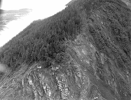

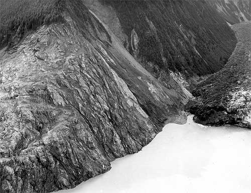
<span class=jpg Trees washed out and turned upslope by water at altitude of 1,720 feet." align="bottom" border="0" height="384" width="500">
Trees washed out and turned upslope by water at altitude of 1,720 feet. Small slides occurred on steep slope at right during the 1958 earthquake, but destruction of forest in middle and lower left part of view is due mainly to water. Lituya district, Alaska Gulf region, Alaska. Glacier Bay National Park and Preserve. Plate 7-A in U.S. Geological Survey.
Photograph courtesy U.S. Geological Survey


The weather also plays a role in the bay as it gets a large amount of precipitation - mostly rainfall. Some of the inland areas along the coast between Lituya Bay and Yakutat have had more than 300 inches of rain according to the National Weather Service and the winter and spring of 1958 was a wet one throughout Southeast Alaska. The ground in Lituya Bay - which frequently gets up to 150 inches of rain a year - was oversaturated even though it was sunny that July.

The third factor was the massive earthquakes that frequently topped 6 and 7 on Richter Scale in the area.

A final factor was the deep water - up to 800 feet - near the head of the bay. When earthquakes or other events caused landslides, they would displace large amounts of water sending it rushing toward the narrow mouth of the bay and the open ocean.

Federal geologist Don Miller was the foremost expert on Lituya Bay in the 1950s and the early 1960s. In his 1960 report, "Giant Waves in Lituya Bay Alaska." he pointed out evidence of five "giant" waves created primarily by land or glacier slides between 1853 and 1958.
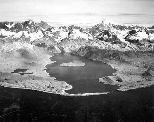

<span class=jpg Lituya Bay, 1954, trimlines of the 1936 giant waves and the 1853-54 giant wave" align="bottom" border="0" height="397" width="500">
Aerial view of Lituya Bay, 1954, trimlines of the 1936 giant waves and the 1853-54 giant wave. Lateral moraines and the end moraine in the right and left foreground record a recent advance of ice to the mouth of the bay. Mount Crillon altitude 12,726 feet is the highest peak on the skyline. Lituya district, Alaska Gulf region, Alaska. September 16, 1954. Plate 3-A in U.S. Geological Survey.
Photograph courtesy U.S. Geological Survey


The 1853-54 wave was estimated at 395 feet, the 1874 wave at 80 feet, the 1899 wave at 200 feet, the 1936 wave at 490 feet and the 1958 behemoth swept trees off a hillside at more than 1,720 feet.

In addition to those giant waves, the waters of Lituya Bay had also been the site of several other disasters involving both the native Tlingit tribes and groups of American, British and French explorers and adventurers from the 1780s into the Twentieth Century, according to Philip Fradkin in his 2001 book "Wildest Alaska: Journeys of Great Peril in Lituya Bay."

Most of these involved the deadly, narrow entrance that featured tide rips and waters running up to 13 knots in either direction. Most notable was a disaster that cost French explorer Jean-Francois La Perouse more than 20 of his sailors. Fradkin also noted that Tlingit oral tradition featured several stories of "giant" waves and mass drownings in the bay.

Three Boats In the Bay

There were two commonly used anchorages near the mouth of Lituya Bay on that July night in 1958. Ulrich and his eight-year-old son "Sonny" chose to anchor about half a mile in from the mouth on the south side of the bay in place called, appropriately enough "Anchorage Cove."

Two other trolling boats, the Sunmore (with Orville and Mickey Wagner on board) and the Badger (operated by Bill and Vivian Swanson) anchored up on the opposite side of the bay, just behind the nearly mile long spit that extended most of the way across the mouth of the bay. The opening itself was less than 300 yards across and most of that water was too shallow for boats to cross. Some fishermen estimate there may less than 50 feet of open water at times.

The Ulrichs had anchored up just after 8 pm, while the other two boats - running partners who both lived in Juneau - anchored up around 9 pm.

Around 8 pm, a plane took off from near Cenotaph Island (so named after the drowning of the 20 French sailors in 1786). On board were 10 Canadians who had just returned from the first Canadian ascent of Mount Fairweather.
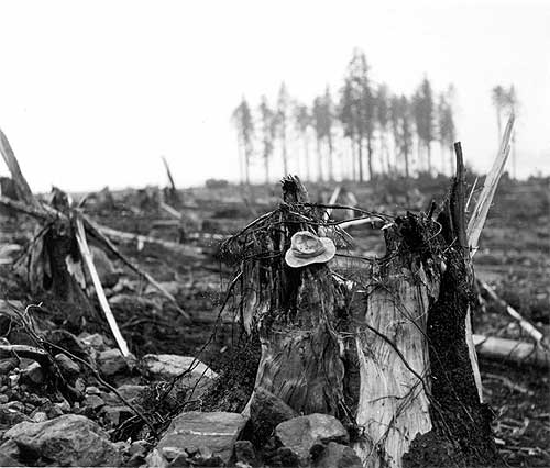

<span class=jpg Stump of living spruce tree broken off by the giant wave at Harbor Point, mouth of Lituya Bay" align="bottom" border="0" height="426" width="500">
Stump of living spruce tree broken off by the giant wave at Harbor Point, mouth of Lituya Bay. Brim of hat is 12 inches in diameter. Lituya district, Alaska Gulf region, Alaska. Plate 5-B in U.S. Geological Survey.
Photograph courtesy U.S. Geological Survey

"The expedition was scheduled to leave the following day, but the pilot of their Royal Canadian Air Force amphibian arrived at 6 pm that night and told them to pack immediately," Fradkin wrote in "Wildest Alaska." "He was worried about the possibility of fog and wanted to get the climbers back to Juneau that night. The climbers cursed the pilot's nervousness. They missed dinner in a hurry to pack and departed at 9 pm. Another party of climbers was due that day by boat but they had been delayedHad the two groups proceeded as planned, there would have been a total of 20 climbers camped on the shoreline that night."

Fradkin noted that the Canadian climbers weren't the only living things making a fortuitous getaway from the bay.

"As the Canadian climbers flew away, so did the nervous kittiwakes (that nested on the cliffs of Cenotaph Island)," Fradkin wrote. "The gulls ascended like so much confetti blown upward. The high intensity alarm call of thousands of birds echoed through the still bay. They passed over the Badger and splattered the boat with droppings. Some crashed into the vessel's rigging and plummeted to the deck. The Swansons were frightened."

Up and down the coast as far as Yakutat and Hoonah observers would report similar odd behavior by shore birds and other animals. Then, at approximately 10:16 pm, it happened.

"Cursing Myself For Not Moving Sooner"

The quake was later determined to be 8.3 on the earthquake scale and was centered 45 miles south of Lituya in Cross Sound. It was felt strongly as far south as Seattle and as far north as Anchorage. At Yakutat, 80 miles to the north of Lituya, three people out berry picking died instantly when a small island they were on immediately dropped more than two dozen feet under the water. Later measurements determined that a nearby mountain had risen more than 50 feet at the same time.

Overall, the earth had moved some 21 feet horizontally and 3.5 feet vertically along most of the fault line. While most earthquakes last only a few seconds, the initial length of the quake was later estimated at more than two minutes by Don Miller.

Then Lituya Bay got hit with the other shoe.

Miller - who was in Glacier Bay at the time of quake and flew to Lituya the next day - determined that less than two minutes after the initial tremor, the side of an unnamed 5,616 foot peak on the east side of Gilbert Inlet (at the head of the bay) plunged into the bay. At least 2,000 feet of rock fell.

"The noise was deafening," Fradkin wrote. "The violent impact of forty million cubic yards of rock, ice and coarse soil weighing ninety million tonswas heard 50 miles to the north. Ulrich said it sounded like an explosion."

With the first jolt, Bill Swanson tumbled out of his bunk on the Badger. He later told the Alaska Sportsman that the he could see even the highest mountains shaking. Then he saw the Lituya Glacier appear to literally rise up into the air.

"I know you can't ordinarily see that glacier from where I was anchored," he was quoted in the October, 1958 issue. "People shake their head when I tell them I saw it that night. I can't help it if they don't believe mebut I know what I saw that night."

From his vantage point, he could also see the mountainside slide away and crash towards the water. From his viewpoint on the other side of the bay, Ulrich could see the wave rise up and devastate the forested hillside.

All three boat crews had been woken up by the earthquake. But while the captains of the Badger and Edrie were transfixed by the spectacle at the head of the bay, the Wagners on the Sunmore jumped to immediate action and got their boat headed out of the bay.

It proved to be a fatal decision. Swanson reported seeing the Sunmore just about to turn out into the entrance when it was caught by the wave and flung over Harbor Point across the opening from the end of the spit. All that was found later was an oil slick marking the spot where the boat went down in deep water.

Ulrich told Alaska Sportsman that he was "petrified" by the landslide and the wave and didn't begin to act until he saw the wave, then still some 300 feet high engulf Cenotaph Island some two miles away from his boat.

"I began to move then," he said. "And I moved fast, cursing myself for not moving sooner."

" I Think We've Had It. Goodbye"

He got a life jacket on his son and started the engine. He started to pull the anchor and found it unmovable.

"The wave (then estimated at more than 75 feet high) was almost upon us and we were fastened to the bottom with a heavy chain," Ulrich said. He surmised that the quake had caused the anchor to get tangled on the bottom. He let out all his extra chain, in hopes that it would be enough to allow the boat to ride up and over the wave. Then he turned the boat into the wave and held on.
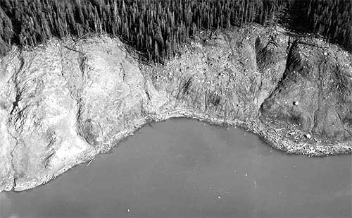

Southeast Alaska Earthquake, July 10, 1958. Wave damage on the south shore of Lituya Bay, from Harbor Point to the spur southwest of Crillon Inlet. August 9, 1958. Photos mdj01247 through mdj01261 form a sequence of fifteen photographs.
Photograph courtesy U.S. Geological Survey


"As the Edrie began her almost perpendicular ascent to the crest of the wave, the chain snapped," Ulrich said, adding that he wanted to get a message out so his wife in Pelican would eventually find out her husband and son had died. "There seemed to be no hope for survivalI grabbed the handset of my radiophone and yelled into it: 'Mayday! Mayday! This is the Edrie in in Lituya Bay. All hell has broken loose in hereI think we've had it. Goodbye.' "

But the luck that had abandoned the Wagners was still on Ulrich's side. At the top of wave, he regained enough control of his boat to hold on and steer around the debris being carried by the wave. A few seconds later, the worst had passed.

He sent out another message saying he thought they'd made it through. Immediately, other boats outside Lituya began radioing back. But, Ulrich noted, the silence from the Badger and the Sunmore was ominous.

Just about the time that Bill Swanson saw the wave engulf the Sunmore as it tried to escape, the wave - estimated to be approximately 80 feet high - hit his boat and carried it over the La Chaussee Spit and dumped it stern first into the open ocean.

"We went way over the trees and I looked down on rocks as big as an ordinary house as we crossed the spit," Swanson told the Alaska Sportsman. "We were way up above them. It felt like we were in a tin can and somebody was shaking it."

After the crash landing, the boat immediately began to sink. They were surrounded by acres of wood debris - including a large tree that smashed through the pilot house and broke several of Swanson's ribs - but managed to get into eight foot skiff with only their underclothes on, according to Fradkin's book. At nearly midnight, they were found by the crew of the vessel Lumen which was picking its way through the miles of debris looking for signs of survivors in the pitch dark.

After surviving the giant Lituya wave, Ulrich continued to fish but then quit the business a year later. As recently as 2004, he was still reliving the events of July 9, 1958. He wrote a brief story that appeared in Esquire magazine about that night under the title "What it Feels Like to Survive a Tsunami."

The Swansons eventually got a replacement boat, but Vivian - whose hair reportedly turned gray overnight after the Lituya incident - refused to go fishing with Bill again, according to Fradkin.

On the night of May 26, 1962. Bill Swanson returned to Lituya Bay for the first time since the wave in 1958. Shortly after passing through the narrow entrance to the bay, he suffered a massive heart attack and died.


WEATHER NOTE

LATEST ON FAY


Web makes it easy for stormchasers to track weather
ROBERT NOLIN

In ancient times, before the Internet ruled the world, folks needed pencil, straightedge and a rudimentary knowledge of latitude and longitude to track a storm like the wannabe tropical depression now knocking at the Caribbean's door.

No longer.

Now all an amateur storm chaser needs is a keyboard and mouse. In recent years, meteorological-based Web sites, including that of the U.S. government's own National Hurricane Center, have become sophisticated enough to drench even the most demanding weather buff with information.

"They've improved, they're faster, they have more information," said Scott Weiner, 41, who flicks on the computer when he hankers to follow a storm's progress. "The first place I go is the (South Florida) Sun Sentinel."

This newspaper's hurricane-related Web fixture, sunsentinel.com/hurricane, offers real-time storm tracking, a weather blog, satellite maps, storm histories and other features.

With an average of 38 million page views a month, the Weather Channel's Web site, weather.com, leads the pack in terms of popularity, according to Nielsen/NetRating. Users charting a storm don't want to wait for broadcast reports, site spokeswoman Melissa Medori said.

"I guess it's the usage pattern of 'I want it now. I don't want to have to wait for the next update,'" she said.

Rapid, frequent updates are indeed the draw for Weiner, as are fancy graphics and blogs. "I want to look at the maps, the projections," he said. "TV weather is useless."

If a storm is thrashing around the neighborhood, visits to weather Web sites spike.

"When there's any tropical storm or hurricane threatening land, especially U.S. soil, our traffic goes up approximately 50 percent," said Toby Skinner of The Weather Underground, the second-most popular site. "We talking such huge numbers we have to make plans to make sure our whole system doesn't break down."

Last month, when Hurricane Dolly barreled toward Texas, about 22 million visited wunderground.com in one day, Skinner said. "It's even more than we had with Katrina," he added, referring to the 2005 hurricane that wrecked New Orleans. "We're showing gradual increases year upon year."

Weather Web sites all use the same material from the National Hurricane Center in Miami-Dade County, but they customize maps, computer model tracks and snazzy graphics to enthrall viewers. Weather.com tosses in raw storm videos, photos and pet pictures. Another site, skeetobiteweather.com, prides itself on a more businesslike presentation.

The hurricane center has jazzed up its own site Web site to make it more layperson-friendly, said spokesman Dennis Feltgen. "We're in the 21st Century, we've got high-resolution graphics, we've taken the text piece and basically made it graphical."

The result, he said, has drawn 4 million page clicks to the site so far this year - not bad for a government venue. "They're clearly seeking the information out and they're quite savvy," Feltgen said of the mouse-wielding public.

But he cautioned that big decisions, such as when to shutter up or evacuate, should be left to professionals, and not armchair prognosticators.

"We certainly would not encourage them to make their own interpretation of track forecasts and intensity forecasts," he said. "We've got a number of scientists here at the center and that's what they're trained to do."

Hurricanes and climate change: A sharper view

August 13, 2008

In a study published in the July 2008 issue of Geophysical Research Letters, Drs. David S. Nolan and Eric D. Rappin from the University of Miami's Rosenstiel School of Marine and Atmospheric Science describe a new method for evaluating the frequency of hurricane formation in present and future tropical climates. While current thinking about changes in hurricane frequency comes mostly from computer simulations of global climate, the computer models used for these studies can only represent the coarsest features of hurricanes, thus casting doubt in their predictions of hurricane activity.

The new approach by Nolan and Rappin, developed in collaboration with Dr. Kerry Emanuel of the Massachusetts Institute of Technology, uses computer models with much more accurate representation of the processes that lead to hurricane formation, much the same way a digital image with more pixels allows for a more detailed photographic image. The models are used to simulate the rate of hurricane development in tropical atmospheres with varying values of sea surface temperature and vertical wind shear (which is the extent to which wind speed and direction changes with height in the atmosphere). These two variables - ocean temperature and wind shear -- are considered to be the two most important factors in predicting hurricane activity, both in operational forecasting and in consideration of climate change.

MARITIME NOTE

Riverdance ferry - a sorry sight


These pictures by Gazette photographer Bill Johnson show the pitiful remains of the wrecked Riverdance ferry – seven months after it ran aground off the Cleveleys coast.

What began as a huge tourist attraction – the sight of the beached vessel has brought thousands of trippers to the seafront – now looks more like a rusted shed as demolition teams have reduced it to a sorry sight.

Both engines have been removed from the 6,000 tonne ship and carted off to a spares company in the North East of England.

More than 34,000 litres of oil had to be taken off the stricken cargo ferry and other potential marine pollutants have also been removed. It will not be long before the wreck – which has been photographed by visitors from across the world since it became beached in heavy seas on January 31 – is completely removed.

Demolition experts from Hancock's Contractors Ltd and PGC Demolition Ltd have been working over the last two months to dismantle the ship piece by piece.

But it is painstaking and difficult work – depending on the weather and tidal patterns.

Fred Caygill, from the Maritime and Coastguard Agency, said: "The vessel has been stripped down internally, it's only the shell that remains.

"Sections are being cut off and the pieces being transported for recycling.

"The teams are making good progress and have done meticulous work.

"There is not a lot left of the ship now. All the work has been done without any loss or damage to the local environment.

"The work still remains on schedule, but we cannot give an exact completion date because it depends on the tides and the weather.

"But we are expecting the work to be completed around the end of September to early October."


RS

Monday, June 30, 2008

Maine's set the bar high for flood warning

Maine's set the bar high for flood warning

Emergency management officials in New Brunswick are considering adopting a method similar to the one used in Maine to better warn residents when a major flood is coming.

Dick Isabelle, the province's executive director of emergency services, said that he favours implementing a system where local authorities are actively engaged in alerting the public when flooding is imminent.

Faced with an ugly forecast for torrential rain and a river already near its crest, disaster officials in Aroostook County, Maine, went door to door on the night of April 29 to make sure people knew they were in danger.

Across the border in northwestern New Brunswick, however, many residents were caught off guard. Although the province issued a flood warning on April 29 for the entire length of the St. John River, it wasn't taken seriously enough by people in areas that are not prone to being submerged.

In northern Maine, to make sure nobody was unaware, police set up blockades and vans rode down streets issuing warnings over their public address systems.

"I think we have to evaluate the effectiveness of our entire system, and not be afraid to stand up and say, 'Let's see what we can do better. How can we give people the proper warning they deserve?' " Isabelle said. "My guess is that the type of system we will encourage is one where we work more closely with local authorities.

"I would say that this is an area we see as having to explore."

As of last week, nearly 500 flood victims had sought government aid in northern New Brunswick, and 1,358 people were seeking assistance overall. Approximately 130 people remained displaced and were in temporary housing.

Under fire from the Opposition in the legislature last week, Premier Shawn Graham described the province's emergency system as having worked well, but said a review would be undertaken.

The province takes out advertisements to warn residents of flooding and updates water and weather conditions on its River Watch website, and usually that is enough, the premier said.

"It is important to note that this was a severe flood; we had not seen a flood of this magnitude and severity for many generations,'' Graham said. "In fact, areas were flooded that had never flooded in the past.

"As I have always stated, a complete review of this initiative will be undertaken, and we will be looking to make improvements where we can. But the reality is that the system is working.

"The severity of the flood was not anticipated. We cannot control Mother Nature. This is an important notice for all New Brunswickers today: When emergency management issues flood warnings, precautions should be taken."

Opposition Leader Jeannot Volpé and Percy Mockler, the member of the Legislative Assembly for Restigouche-La-Vallee, argued that the warning system failed to adequately alert residents in northern communities. They also complained that communication was poor between relief agencies, and that people calling for help were transferred from one agency to another and another.

"We all know what is happening now,'' Volpé said. "It is a reaction. What I am asking is, what should be done so emergency management officials can advise people when a flood is coming? How is it that people can save some of their assets by knowing ahead of time? Not the next day, or three days after, because then it is too late.

"People have lost a lot of money and a lot of assets. They were not ready because nobody told them what was coming down."

Marty Klinkenberg is a contributing editor of the Telegraph-Journal. He can be reached at martyklinkenberg@hotmail.com

WEATHER NOTE

Are you prepared for natural disaster

By RICH ECKE
TRIBUNE STAFF WRITER

Montana doesn't encounter many natural disasters. Earthquakes are rare, and Great Falls is on the fringe of the fault zone, although Kalispell, Helena and other cities closer to the Rocky Mountains face more danger from a quake. Big Sky Country avoids hurricanes, monsoon rains and tsunamis.Far from Tornado Alley, Montana gets an occasional twister, but it usually just throws a bunch of dirt around in this sparsely populated state.

Great Falls is one of the country's windier cities, and so are other towns along the Rocky Mountain Front, and places like Livingston. The wind may rage, but it usually doesn't kill anyone.Montana gets cold at times, and below-zero blizzards put people in danger in winter.

The state also gets freak snowstorms, like the recent one that knocked out power to much of Great Falls and the surrounding area. About 100 rural homes lost power for days.

Losing power for several hours was not a major disaster for most people, but it showed how unprepared some people are for trouble, said Judy Powell, a national Red Cross reservist who has assisted at more than a dozen disasters across the continent.

During the recent power outage, some people did not even know how to open their garage door manually, Powell pointed out. She thinks it's better to be prepared.(By the way, your garage door opener usually has a red plastic handle attached to a rope. You pull on the handle to disconnect your garage door from the electric opener. Then you can open the garage door by hand.)

Anyway, one of Montana's few natural disasters, aside from fires, is flooding."It's that time of year for floods," said Karl Christian, conservation district specialist for the state Department of Natural Resources and Conservation in Helena. Parts of Iowa, Wisconsin and other states in the Midwest certainly have gotten nailed this month, as shown by horrifying videos of houses floating down swollen rivers.

Central Montana is wetter than usual. Great Falls has enjoyed 10 inches of moisture through mid-June, already two-thirds of the rain and snow we normally get for a whole year. Fifteen inches is average.

Melting mountain snow will add to the already high Missouri River through Great Falls. Temperatures in the 80s would hasten the melt. Then all it would take is some heavy rain to send water over the river banks. Complacency is the number one thing we can't do," Powell said Sunday.

Sure, our parched landscape has sucked up most of the generous moisture so far. And flood worries will soon fade away. But Powell argues it's better to be ready. She lives next to the Missouri River south of the city, and she has reserved her brother's four-horse trailer to move all of her belongings out during an emergency.

Once in Kentucky, Powell remembers visiting with a family whose treasured family photographs had been sitting in flood waters for two days. The photos could not be salvaged. "I came home and put all of my pictures in a plastic tote and keep them on a high closet shelf," Powell said.

Think about where your family photos are and where they would be safest in your house. A leaky roof can do the same thing as a flood. Flood events set for this week

Even if we escape bad floods in 2008, we can still reminisce about some horrendous floods that have befouled Great Falls and the surrounding area over the years. During the 20th century, 1908, 1953, 1964 and 1975 were soggy, especially for west Great Falls and outlying areas. Broken dams also didn't help in some of those years.

To commemorate the pluck and vigor of people who encountered deadly floods in Montana over the years, the Missouri River Conservation Districts Council will hold a Missouri River Flood Photo Round-Up in Fort Benton and Great Falls this week. A third event will be July 14 in Helena.

If you have any neat photos of past Missouri River flooding, come to the Ag Museum in Fort Benton on Thursday, or Friday to the Mountain West Bank, 12 3rd St. N.W., from 4 to 8 p.m. both days. The Helena event is July 14 at the USDA Building, 790 Colleen Street. Local conservation district representatives will be on hand, and refreshments will be served.

At these gatherings, someone will scan your photos for you, and hear what you have to say about the flood of 1964, or, if you're 110 years old, the flood of 1908. You may want to trade stories with other flood survivors. Call Christian at 406-444-3022 or Vicki Marquis at 406-231-5818 for more information.


State works to retain hurricane relief funds

By Ana Radelat
Gannett News Service

WASHINGTON — Gov. Bobby Jindal and the Louisiana congressional delegation are working to bridge a dispute between the House and Senate over billions in hurricane recovery money for Louisiana and Mississippi.

The House plans to vote today on a $184 billion emergency spending bill that would pay for the wars in Afghanistan and Iraq and provide $5.8 billion to repair New Orleans' levees.

But the House bill contains no money for other reconstruction efforts the Senate approved in a similar bill last month. That includes $70 million for housing vouchers for low-income Louisianians at risk of homelessness and $157 million to help the state's hospitals cover expenses related to Hurricane Katrina.

The Senate bill also would provide $50 million for upgrades in the state's criminal justice system and reduce — from $1.5 billion to $1.3 billion — the state's share of the cost of rebuilding levees. Many of the Katrina-related provisions were sponsored by Sen. Mary Landrieu, D-New Orleans.

The House rejected those provisions — and about $10 billion in other local projects — to avoid a presidential veto or, failing that, win enough GOP support to override it.

President Bush had approved the money to rebuild the levees, but objected to much of the other domestic spending the Senate had included in the bill.

Complicating the chances of the state getting the extra money, the House agreed to provide billions of dollars in emergency floor relief for the Midwest.

Jindal was to meet Wednesday afternoon with retired Marine Maj. Gen. Doug O'Dell, Bush's recently appointed coordinator of Gulf Coast rebuilding, and other administration officials to lobby them on the hurricane recovery funding.

In addition, the Louisiana congressional delegation hopes to meet with House leaders early next week on the issue.

Rep. Rodney Alexander, R-Quitman, said it would be better to hand the president a final bill that includes some hurricane spending but limits other domestic spending and doesn't restrict how the war is conducted.

"We would like to see language that doesn't have poison pills," Alexander said.

The governor also said there may not be another bill moving in Congress this year that could include the hurricane recovery money, which he called "critical to Louisiana and time-sensitive."

Sen. David Vitter, R-Metairie, urged House leaders to accept the Senate's provisions because a final bill is unlikely to win White House approval.

"The president is going to veto it anyway," Vitter said.

If the House approves a pared-down bill Thursday, it will go to the Senate for consideration. But the Senate is likely to reject it in favor of the bill it approved last month, creating new delays in approving money to conduct the war.

"It looks, unfortunately, like this will pingpong down the way some more," Vitter said.

New book spells out secrets to surviving disaster

THE UNTHINKABLE: Who Survives When Disaster Strikes - and Why by Amanda Ripley, Crown, $24.95

"We all have ideas about what we might do in a [public] emergency," writes Amanda Ripley in "The Unthinkable: Who Survives When Disaster Strikes - and Why." "But we are probably wrong."

Here's the likelihood. If you aren't immobilized by profound lethargy - many are - you'll first try to convince yourself that what is happening isn't. Even when it's blazingly obvious that you have to get out, you may feel a strong urge to stay put.

If you're very lucky, someone may break through that denial by shouting a directive, "We have to move!" What you do next will be really stupid. You'll look for your handbag or root for whatever in your desk drawer. If you aren't dead by the time you find it, carrying it will complicate your escape.

Chances are you will be fleeing with a crowd and someone has taken command. But even as you move to safety, if not before, your body will betray you. Your vision could narrow dramatically. You might go temporarily blind. You will forget how to do simple things. Unbuckling a seat belt, for instance, may seem so terribly complex.

Ripley, who reported on disasters and now covers homeland security for Time, became fascinated with all facets of human response to disaster, and "The Unthinkable" is the valuable product of her determined pursuit of answers.

Physiology (the amygdala, specifically) plays a role, as does evolution and genetics. Your intuitive response can help, but if it's your sole guide, it can lead you badly astray. It's a matter not only of knowing yourself but knowing your disaster - the one you're most vulnerable to. As an expert points out, "Disasters have personalities." Some strike more debilitating fear than others. Learning the facts can override that at a critical juncture.

Training is the most essential tool of all. Ripley's pressing point is that all our sophisticated warning systems and emergency procedures are designed to meet the needs of professionals. Civilians are considered a grade below, not to be trusted, though in many, if not most disasters, waiting to be saved can be deadly.

"We were the first responders," says a 9/11 survivor who escaped the World Trade Center.

We are a country built on self-sufficiency, Ripley writes, but we refuse to give ordinary people the information that, when delivered in factual and nonthreatening terms, can save their lives. Perhaps it's time for the rest of us, the potential victims, to signal a Code Red. We need to know. Now.

Our disaster personalities are quite different from our everyday selves.

Milling about gathering information can be useful in some disasters. Just don't prolong it.

Do not, repeat do not, give in to the impulse to gather luggage, handbags or anything. Just get out.

Disaster induces a paralytic lethargy in many people. Sometimes this works to save you. Usually not. Fight it.

Of all passengers involved in serious airplane accidents between 1983 and 2000, 56% survived. But you have seconds, sometimes 90, sometimes less, to get out.

Read the safety diagram on airplanes. Wherever you are, know your exits. Count the rows on a plane. In a fire, always stop, drop and roll.

Fire kills more Americans annually than all other disasters combined. In a hotel, take the stairway down to the ground once to become familiar with the crossovers and other surprises.

Worry about probability. What kind of disaster is most likely to strike your area. Hurricane? Flood? Terrorist attack? Learn what to do in that situation. Train yourself. Then you will be response ready.

Don't be silly about sharks. Worldwide, six humans are fatally attacked annually, while human beings kill between 26 million and 73 million sharks. We're way ahead on this one, folks.

MARITIME NOTE

More problems for Riverdance

TREACHEROUS
weather conditions and shortening summer tides are hampering workmen's efforts to dismantle the wrecked Riverdance ferry.

Bosses at the ship, which is being dismantled on the Anchorsholme coastline, say conditions were so poor last weekend when gushing winds battered the Fylde coast that work on the vessel had to be abandoned on Sunday.

Officers have also warned progress has been slowed by the fact time to work between the tides has been halved as the demolition job heads into the summer.

Donald McDonald, who is overseeing the operation for the Maritime and Coastguard agency, said: "With the high winds on Sunday it would have been dangerous to put people in the situation.

"We don't normally have this kind of weather at this time of year."

GAO Issues Report on Loss of Coast Guard Patrol Boats

U.S. Government Accountability Office's just-issued report; COAST GUARD: Strategies for Mitigating the Loss of Patrol Boats Are Achieving Results in the Near Term, But They Come at a Cost and Longer Term Sustainability Is Unknown (GAO-08-660).

The GAO accomplished this report for the Senate Commerce Committee, Subcommittee on Oceans, Atmosphere, Fisheries and Coast Guard. The report provides some background on the Coast Guard's "bridging strategy" to upgrade aging patrol boats from 110 feet to 123 feet (to include a number of upgrades and stern-launch boat ramp) as part of its Deepwater program. After the Coast Guard upgraded 8 of these boats, the hulls developed hull deformities and other problems and these 123 foot boats were pulled from service.

Most of the report discusses the Coast Guard's strategies for dealing with the loss of these boats and its impact on District 7 (waters off Florida, and some adjoining states) where all of them were based. One of the main Coast Guard homeland security missions in this district is the interdiction of migrants. The Coast Guard strategies to replace operational hours in District 7 included: double-crewing existing patrol boats, deploying patrol boats to District 7 from adjacent districts, using Navy patrol boats, increasing operational hours of other patrol boats, and revising boat maintenance programs. While these strategies have been successful in raising patrol boat operational hours in District 7, they have also raised certain costs and diverted some missions in adjacent districts. For example, adjacent districts are doing less enforcement of marine fisheries and less maintenance of aids-to-navigation. This fits into a broader theme of GAO work that demonstrates that the Coast Guard is having difficulty meeting all of its mission requirements (particularly non-homeland security missions) within the current level of resources. The Coast Guard will have to maintain these increased costs (both in dollar expenses and mission opportunity costs) as it awaits the deployment of new smaller less capable 87 foot patrol boats, and a new generation of boats known as Fast Response Cutters.

This briefing comes courtesy of Stephen L. Caldwell / Director, Maritime Security Issues / Homeland Security and Justice Team / U.S. Government Accountability Office / (202) 512-9610. Click HERE to read the full report.

Waterspouts seen over Lake Erie

Published: June 19. 2008 11:53AM


Shipping firm to sue Philippine weather agency for mishap

Manila, June 27 (Xinhua) The owner of a Philippine ferry that sank in the devastating Typhoon Fengshen with more than 800 people on board said Friday he would sue the country’s weather agency for not giving timely information about the typhoon. According to Philippine TV network GMA News, shipping company Sulpicio Lines, which owned the sunken ship MV Princess of the Stars, said it would charge the Philippine Atmospheric, Geophysical and Astronomical Services Administration (Pagasa) next week for failing to update the ship’s crew about the movement of Typhoon Fengshen.

At least 70 passengers were confirmed killed when the MV Princess of the Stars sank off Sibuyan Island, 300 km south of Manila. More than 740 people are still missing and feared dead, while 48 have survived the accident - the worst in the past two decades.

Sulpicio Lines’ lawyer Arthur Lim said the shipping company will charge Pagasa with gross incompetence and negligence, saying that the ferry could have averted the tragedy had Pagasa issued an additional warning on the typhoon’s movement.

Lim said the ship’s route from Manila to Cebu was not completely reflected in the Pagasa bulletin they received before sailing.

At the Board of Marine Inquiry investigation earlier Friday, Nestor Ponteres, Sulpicio’s port captain in Cebu, claimed that the company was informed six hours late by Pagasa regarding typhoon Fengshen’s changing course.

Ponteres also claimed he was in constant communication with the ferry’s captain, Florencio Marimon Sr, before the ship sank. Marimon is still missing.

Ponteres added that there were alternate routes that the ship could have taken had the warning been relayed earlier.

But Pagasa director Prisco Nilo said that they always make sure to release weather updates to the public even though predicting the behavior of a typhoon cannot always be precise.

“Anywhere you go, the warnings and the bulletins are updated a number of times in a day, usually four times a day taking into consideration that (weather) forecasting is not an exact science,” Nilo said, adding that shipping companies also have the responsibility to closely monitor the weather condition to ensure its vessels’ safety.

Sulpicio Lines had earlier blamed the Philippine Coast Guard for the tragedy, saying Wednesday that it was the Coast Guard’s task to plot routes for vessels during inclement weather.

The Board of Marine Inquiry, however, said the 1998 memorandum circular on which Sulpicio Lines based its arguments had been replaced with an updated June 2007 memorandum circular that places responsibility on the ship’s owner and captain.


RS

Tuesday, June 17, 2008

Rowing the Atlantic and Roz Savage

I lead into todays blog with the following articles......

U.S. Coast Guard rescues charity rowers

Sat Jun 14, 2008 12:47pm BST

(Reuters) - Four Britons attempting to row across the Atlantic for charity have been rescued by the U.S. Coast Guard after their boat capsized, British officials said.

The 29-foot boat of rowers Chris Jenkins, Tim Garrent, Wayne Davey and Joby Newton capsized 420 nautical miles east of Cape Cod early on Saturday, while the men were in the boat's two cabins.

"The crew have been taken aboard the Gulf Grace at 8 a.m. -- we understand all are relatively safe and well, but suffering slight hypothermia," British coastguards said in a statement.

The Britons had been attempting to row from New York to the Isles of Scilly to try to break the record of 55 days set in 1896 by George Harboe and Frank Samuelson on a route that has only been successfully completed six times.

The four men, who had been expected to each burn around 10,000 calories a day rowing two hours on, two hours off, day and night, had so raised nearly 75,000 pounds for four different charities after leaving New York on June. (END)

Trans-Atlantic Rowboat Trip Becomes Coast Guard Rescue

Ă‚ BOSTON - The 26-year-old who set out alone to row his custom-made boat across nearly 4000 miles of open ocean Wednesday was rescued by the Coast Guard Thursday night 50 miles east of Provincetown, Mass.

Charlie Girard was in distress and caught in 5-8 foot seas and 15-knot winds in his 23-foot boat. He expressed his desire to be taken off the boat to an acquaintance of his, Richard Williams of Orleans, Mass. via a satellite phone.

Williams contacted Coast Guard Sector Southeastern New England about 7:20 p.m. and said Girard, “had taken seven or eight rolls and was ready to come off.”

A Coast Guard HH-60 Jayhawk helicopter crew launched at 8:15, and hoisted Girard to safety about 9 p.m.

Coast Guard Petty Officer First Class John Hughes, the onboard medical corpsman said, “he was thrown around quite a bit and said he slammed into the side of the boat and that his lower back was bothering him.”

He was taken to Air Station Cape Cod and was transferred to an awaiting ambulance.

The Coast Guard issued a safety marine information broadcast to notify other mariners of the adrift rowboat. (END)

Success is about Team Work and Prepardness!

While some causes for charities and ocean plights are noble and very worth while. Poor pre-planning and crisis management can lead not just to disaster but death. No one can stop anyone from risking their own lives, but we all have to remember that not only do we risk ourselves but we risk those who are sent to rescue us. Pre-planning and having a expert team in place to stay on top of all the details during an ocean crossing is to say the least... critical. I am talking about a real operational team. Those dedicated to the journey, the person and the events on a day to day basis..

This team needs to be comprised of experts in various fields., such as medical, communications, rowing, meteorology, oceanography, marine engineering and crisis management. Many who attempt these crossing do not even have a solid SOS plan or even a chase boat within range or at a jump off point for relief or redundant plans for a SOS in case they get into trouble.

The British rowers were lucky they were in range for a US Coast Guard rescue. There is a point of no return, where people are actually on their own and challenge mother nature in all her glory....and mother nature can be a witch at any moment...

Many of the people who undertake these extraordinary adventures either do not have the proper teams assembled or just listen to what they want. Worse yet when they run into problems they sometimes risk all including their lives for the cause or venture. In some of these cases some of these people do not even want to share float plans or contact data with rescue agencies prior to departure because of past track records or fear of being stopped.

In one case not cutting a tangled para sea anchor in heavy weather (which is not designed for a row boat) because it is not politically "Green" to those trying to save the earths oceans from pollution and the thought of cutting the tangled sea anchor in heavy weather is in their opinion equivalent to polluting the ocean, is like playing russian roulette with a machine gun. Or those who believe that having a chase boat come to ones assistance is also not green politically correct because it leaves a "carbon footprint" might as well play russian roulette with a hand grenade.

Imagine having a para-sea anchor like this one (Note: this is not the brand being deployed) tangled with your broken trip line in heavy seas and not wanting to cut it lose because you consider it polluting the ocean. How about imagining that tangled sea anchor being pulled either to your port or starboard and pulling your row boat broadside to a 20 foot wave or draging you down? Know the danger you would be in? Think sinking that row boat and potentially drowning is not a form of pollution?

Both adventurers and team members who act in these types of manner are doing no one any good and actually are a danger not just to themselves but to anyone they consult to.


Roz Savage

What good is your cause if while trying to draw attention to it you die because of stupidity? What signal does that send to everyone? What is the benefit to the cause, the sponsors, yourself, your family and those around you if you do not survive?

While I support some of these folk and their causes, like I once did for Ms. Savage. What I do not support is poor planning, stubbornness, lack of coordination with rescue agencies and very poor team work with all the ego's that go with that. That in my book is a recipe for disaster and death on the high seas. To update this posting as of 17 June 2008. I have many concerns and problems with the way Ms. Savage and some of those around her are handling this so-called cause and adventure. Not to have a proper plan in place with a expert team for guidance and if necessary rescue is plainly stupid. One can always try again if one remains alive. Not to coordinate or purposely withhold critical life safety information from the United States Coast Guard such as your EPIRB identification and/or any contact information on a transatlantic or pacific crossing such as Ms. Savage and part of her team did is plainly mind boggling.

cradle or attached to a life raft where it needs to be in case her boat capsizes again. To think that one might be able to grab a I wish all those attempting these extraordinary acts fair winds. But I sure wish they would take their heads out of their butts and do it the right way... Roz Savage is now off the coast of California still having her problems. We note that on her 15 June 2008 posting that her EPIRB is not properly deployed and to activate a EPIRB that is not properly deployed during a crisis is very difficult and just plainly bone-headed..... As of the 15 Savage was out of communications for just about 24 hours. There seems to be some around her that push the rescue goal post further out than need be.

Late on the 16th Savage regained communications and states all is fine with exception of being sea sick. There is in my opinion a lot missing on her blog since the blackout and some of the problems she indicated she was having. There is no explanation for the blackout in communications. While the rescue button was moved from the so-called four hour blackout window which started at around 1300 hrs PSTon the 16th to a 2100 hrs PST her normal contact time. Which would have been a night time search and rescue operation. This places rescuers in a very difficult and dangerous position.

I remind all that the last time Ms. Savage was rescued, it was someone else requesting the rescue because Ms. Savage refused to declare an emergency when she was confronted with disaster.

As i have told Ms. Savage. What good is fighting for your cause if your dead.

Roz we all hope the best for you. But with the problems your having you need to smarten up and get a grip.

Mission: Find the Brocade


USCG RESCUE FOOTAGE


WEATHER NOTE

(Here are a couple more chowder-heads! Of which is common in the Chicago area. Another story here. I attended a Emergency Management meeting the other day to talk about severe weather preparedness. One of the participants was with the USCG. He relayed that a few days earlier one of his boats crossing Lake Michigan came across a guy who was floating on a inflatable mattress with a six pack drunk as a skunk... It makes you wonder?)

Two rescued from Lake Michigan during downpo

Two men were rescued while paddling in canoes on Lake Michigan Sunday morning during a torrential downpour.

Marine Unit officers spotted two men paddling on Lake Michigan near Navy Pier about 7:30 a.m., just as dark clouds filled the skies and a downpour hit, Chicago Police Marine Unit Sgt. Ray Mazzola said.

“When they were even with us, we got a call that their canoe had overturned,” Mazzola said.

The men were rescued and taken to Northwestern Memorial Hospital, Mazzola said.

One of the men was hospitalized with beginning stages of hypothermia, and the other man was taken in for a general checkup, Mazzola said.

The men were rescued about 8:10 a.m., according to police News Affairs Officer Laura Kubiak.

AGAIN TWO LUCKY CHASERS


MARITIME NOTE

Last bow for Riverdance ferry


Up close with the demolition work

Published Date:
06 June 2008
COULD this be the last dance?
Work to cut up the stricken ferry Riverdance is progressing fast – with huge chunks from the stern of the ship being removed in the last few days.

Contractors have taken advantage of favourable tide conditions to make good progress on the removal of the Riverdance – with work expected to continue at a steady pace over the next few days.

FREAK WAVES PART III


RS

PS: We have been having some automatic uploading problems with the blog that deletes some words making incomplete sentences. We hope to have this corrected soon....

Wednesday, June 4, 2008

A Global Map of Human Impacts to Marine

A Global Map of Human Impacts to Marine Ecosystems

Why map the human impact to the world's oceans?

What happens in the vast stretches of the world's oceans - both wondrous and worrisome - has too often been out of sight, out of mind.

The sea represents the last major scientific frontier on planet earth - a place where expeditions continue to discover not only new species, but even new phyla. The role of these species in the ecosystem, where they sit in the tree of life, and how they respond to environmental changes really do constitute mysteries of the deep. Despite technological advances that now allow people to access, exploit or affect nearly all parts of the ocean, we still understand very little of the ocean's biodiversity and how it is changing under our influence.

The goal of the research presented here is to estimate and visualize, for the first time, the global impact humans are having on the ocean's ecosystems.

Our analysis, published in Science, February 15, 2008 (no subscription required), shows that over 40% of the world's oceans are heavily affected by human activities and few if any areas remain untouched.

How did we create this map?


There were 4 steps to creating this composite map.

1. We gathered or created maps (with global coverage) of all types of human activities that directly or indirectly have an impact on the ecological communities in the ocean's ecosystems. In total, we used maps for 17 different activities in categories like fishing, climate change, and pollution. We also gathered maps for 14 distinct marine ecosystems and modeled the distribution of 6 others.

2. To estimate the ecological consequences of these activities, we created an approach to quantify the vulnerability of different marine ecosystems (e.g., mangroves, coral reefs, or seamounts) to each of these activities, published in Conservation Biology, October 2007. For example, fertilizer runoff has been shown to have a large effect on coral reefs but a much smaller one on kelp forests.

3. We then created the cumulative impact map by overlaying the 17 threat maps onto the ecosystems, and using the vulnerability scores to translate the threats into a metric of ecological impact.

4. Finally, using global estimates of the condition of marine ecosystems from previous studies, we were able to ground-truth their impact scores.

To learn more about the methods used in this study, see the Supplementary Online Materials in Science.

What does the map tell us?


First, we can compare different locations to determine the least and most impacted regions of the globe.

There are large extents of heavily impacted ocean in the North Sea, the South and East China Seas, and the Bering Sea. Much of the coastal area of Europe, North America, the Caribbean, China and Southeast Asia are also heavily impacted.

The least impacted areas are largely near the poles, but also appear along the north coast of Australia, and small, scattered locations along the coasts of South America, Africa, Indonesia and in the tropical Pacific.


For additional videos of the model and information on the SST data, please visit the National Oceanographic Data Center.

Second, the data summarized in the map provides critical information for evaluating where certain activities can continue with little effect on the oceans, where other activities might need to be stopped or moved to less sensitive areas, and where to focus efforts on protecting the last pristine areas. As management and conservation of the oceans turns toward marine protected areas (MPAs), ecosystem-based management (EBM) and ocean zoning to manage human influence, we hope our study will be useful to managers, conservation groups and policymakers.

WEATHER NOTE

New storms rake Central Indiana

Tornadoes hit Rush, Johnson counties

By Kevin O'Neal and Heather Gillers
kevin.oneal@indystar.com

As residents of the Falcon Point apartments sift through the remains of their homes today and representatives of the Federal Emergency Management Agency arrive to examine the damage from last week's storm, Hoosiers in other parts of the state are likely waking up to new weather carnage.

A succession of storms marched through the state late Tuesday, spawning at least three tornadoes.

The National Weather Service tracked two tornadoes on the ground south of Indianapolis that triggered significant damage reports Tuesday night.

One was initially reported near St. Paul on the Rush-Decatur line, where damage to utility poles was reported and wires were torn down.

Weather service meteorologist Joseph Nield said the same tornado apparently hit the village of Moscow in southern Rush County, where injuries were reported and some people were said to be missing.

Sheriff's deputies were going door to door in the Moscow area to check on residents, said Lt. Ceilia Nigh, a department dispatcher. READ>

Tornado deaths in cars spurs improved warnings

WICHITA, Kan. (AP) -- It's turning out to be a deadly year for tornadoes, especially for drivers caught in a storm's path.

The deaths last month of a Colorado couple whose car was tossed more than 100 yards from a southwest Kansas highway brought the state's total of people killed by twisters while in their vehicle to three in the last 11 months.

That has the Kansas Department of Transportation looking for more effective ways to warn drivers of severe weather and how they should take proper precautions.

While signs near toll booths on the Kansas Turnpike tell drivers to tune into 1610-AM for travel advisories, similar signs aren't posted along the other major east-west corridors of Interstate 70 and U.S. 54.

"We're really trying to hash out what we should put up," said department spokesman Tom Hein. "These storms have encouraged us to look at that and try to find a solution."

Nationally, the number of people killed by tornadoes while in their vehicles -- 14 as of Wednesday -- is the highest annual total since 1998, according to the National Oceanic and Atmospheric Administration's Storm Prediction Center.

A big share of those deaths came on May 10, when tornadoes in Oklahoma and southeast Missouri killed eight people in their cars.

Experts say there is a wealth of technological improvements to help drivers stay on top of severe weather but they must also rely on their own judgment.

"If it doesn't look right, don't drive into it," said Chance Hayes, warning coordination meteorologist for the National Weather Service in Wichita.

Drivers don't always listen to such advice as storm trackers documented as a series of tornadoes barreled through northwest Kansas on May 23. As their cameras recorded clouds churning the dust, vehicles could be seen leisurely driving nearby. READ>

Storms pummel portions of Illinois UNDATED - Parts of Illinois are cleaning up and drying out after storms raked much of the region, flooding some roads and downing trees and power lines.

The National Weather Service says central Illinois got more than three inches of rainfall on Tuesday, notably around Springfield and Decatur.

In Champaign and Urbana, heavy rain led to minor flooding in the basements of some University of Illinois buildings and the studio of WCIA-TV in Champaign.

Winds knocked down power poles along U.S. 67 near Industry, Illinois, about 55 southwest of Peoria. Illinois State Police say the highway was closed. READ>

Organization says government not ready for disaster
By Eloria Newell James, community@leadercall.com

With Hurricane Season beginning today, a watchdog group is highlighting some concerns they say indicate the government is not fully prepared for a natural disaster.

Citing minimum changes in the Federal Emergency Management Agency’s Program, a still strained military presence with the National Guard and heavy dependence on volunteers as concerns, Ben Smilowitz, founder and executive director of the Disaster Accountability Project, said more needs to be done by the government

Smilowitz said there are gaps in the services available to victims of natural disasters.

“Despite recent assurances from leadership at the U.S. Department of Homeland Security (DHS) and FEMA that the Federal government is prepared for a major disaster, significant areas of concern remain that must be resolved before the U.S. disaster management system can honestly represent itself as sufficiently prepared to respond to a disaster requiring federal resources,” Smilowitz said. “Right now our nation has a volunteer force set up to offer victims of natural disasters help. ... I don’t feel that a volunteer force can provide the caliber of care needed after a disaster.” READ>

MARITIME NOTE

Stricken ferry's cargo removed

The stricken ferry Riverdance, which ran aground near Blackpool, has now had all its cargo and trailers removed.

Work on removing its stern, bow and the port side ballast tanks will take place over the next 10 days.

A Maritime and Coastguard Agency spokesman said: "Very good progress has been achieved to date and the overall project remains on schedule."

UK – Riverdance update

The UK Maritime and Coastguard Agency (MCA) issued a press notice stating that significant progress is being made on the dismantling of the ro-ro ferry RIVERDANCE that grounded near Blackpool. (5/30/08).

Arctic countries unprepared for cruise ship accidents: officials

As more cruise liners travel in Arctic waters, fuelled by tourists' interest in the North and made possible by shrinking sea ice, U.S. and Canadian officials are questioning their abilities, as well as those of other Arctic nations, to handle cruise ship accidents.

Speaking at last week's Canadian Arctic Summit in Edmonton, a representative from the U.S. Coast Guard said it doesn't have the resources to respond quickly to a massive rescue operation in the northern Bering Sea and the Arctic waters off Alaska.

"Some things we're looking at is: how much icebreaker time we need up there? Do we put other vessels up there? How much [is] the aircraft response time?" Capt. Michael Inman, the coast guard's chief of response in Juneau, said at the summit.

"All those things we're looking at, we're not at the end point where we know what we're going to have to put there."

Inman said seven cruise ships carrying over 3,000 passengers will be heading to the northern Bering Sea and waters off Alaska this year.

Meanwhile, Inman said, more than 70 cruise ships will travel to Greenland this year, carrying more than 150,000 passengers.

"How do we work in this region in an expanded role in the future? And what are the best ways to actually provide the services required by law?" he said. "We're still looking at that."

U.S. officials said there were 28 North Pole transits by icebreakers between 2004 and 2007, along with the largest number of ships ever in the Barents Sea.

That amount of ship and icebreaker traffic is of concern to Mary Williams, director general of the National Research Council of Canada's Institute for Ocean Technology. READ>

RS


Monday, May 5, 2008

Wind Patterns Could Mask Effects Of Global Warming In Ocean

Wind Patterns Could Mask Effects Of Global Warming In Ocean

ScienceDaily (Feb. 15, 2008) — Scientists at the University of Liverpool have found that natural variability in the earth's atmosphere could be masking the overall effect of global warming in the North Atlantic Ocean.

Scientists have previously found that surface temperatures around the globe have risen over the last 30 years in accord with global warming. New data, however, shows that heat stored in the North Atlantic Ocean has a more complex pattern than initially expected, suggesting that natural changes in the atmosphere also play a role.

The Liverpool team, in collaboration with the University of Duke in the US, analysed 50 years of North Atlantic temperature records and used computer models to assess how the warming and cooling pattern was controlled. They found that the tropics and mid-latitudes have warmed, while the sub-polar regions have cooled.

Professor Ric Williams, from the University's School of Earth and Ocean Sciences, explains: "We found that changes in the heat stored in the North Atlantic corresponded to changes in natural and cyclical winds above the North Atlantic. This pattern of wind movement is called the North Atlantic Oscillation (NAO), which is linked to pressure differences in the atmosphere between Iceland and The Azores.

"The computer model we used to analyse our data helped us to predict how wind and heat exchange with the atmosphere affects the North Atlantic Ocean's heat content over time. We found that the warming over the mid latitudes was due to the wind redistributing heat, while the gain in heat in the tropics and loss in heat at high latitudes was due to an exchange of heat with the atmosphere.

"These local changes in heat storage are typically 10 times larger than any global warming trend. We now need to look at why changes are occurring in wind circulation, as this in itself could be linked to global warming effects."

Although natural variability appears to be masking global warming effects in the ocean, scientists still believe that global warming is occurring, as evident through a wide range of independent signals such as rising surface and atmospheric temperatures, reduced Arctic summer sea ice and the reduced extent of many glaciers showing changes in the environment.

The research is published in Science. This study was jointly supported by the UK Natural Environment Research Council (NERC) and the US National Science Foundation.

Adapted from materials provided by University of Liverpool, via EurekAlert!, a service of AAAS.

Total Lightning...What is it and why is it significant?

For years, information about Cloud to Ground lightning (CGs) has been available from the National Lightning Detection Network (NLDN). The NLDN network, along with the long range lightning detection network which detect CGs over a portion of the oceaninc regions is maintained by Vaisala. Other smaller companies also maintain lightning networks across the continental United States, and other parts of the globe.

However, we know from various field experiments (and human observations) that Cloud to Ground lightning strikes represent only a small portion of the complete electrical signal within a thunderstorms. In fact, cloud flashes comprise the largest percentage of the lightning spectrum in all storms.

Researches from NASA, academia, and the private sector have often longed for better methods to detect and track these cloud flashes. One such method is to develop a ground based lightning mapper which detects radiation sources emitted within the lightning channel. Networks such as these have been installed at several locations across the country by researchers at New Mexico Tech and Vaisala.

Specifically, the North Alabama Lightning Mapping Array (developed by New Mexico Tech) has been operational across the Tennessee Valley since early 2003 and provides forecasters with real-time total lightning information for forecast and warning operations. This information has proved critical in assessing the storm scale characteristics of developing thunderstorms including updraft trends and echo top growth. The ability to correlate these trends with the onset of severe weather has also proved vital to the warning and decision making process. The downside to these ground based networks are the limited range of detectability and the expenses involved in expanding an existing network or installing a new network.

With the launch of the next generation of GOES satellites beginning with GOES-R around 2014, the Geostationary Lightning Mapper (GLM) will provide total lightning information for a large area extending from New Zealand to the west coast of Africa. This will cover a large oceanic region where we now have limited information concerning convective procesess, and also provided greater detail over the severe weather rich region of the continental United States. In addition to the GLM, the GOES-R satellite (and beyond) will contain the Advanced Baseline Imager which will provide high resolution imagery (up to 500 meters in the visible spectrum) at 16 different channels. The temporal resolution will be as great as 30 seconds when the satellite is operation in mesoscale sector format.

For more information on total lightning applications or other collaborative activities ongoing between NASA, UAH, and WFO Huntsville see http://weather.msfc.nasa.gov/sport/

You can select the "Meetings" link for a view of various conferences and individual presentations.

WEATHER NOTE

Storms bring heavy downpours, 59 m.p.h. gusts

By Tom Skilling

May 3, 2008

Gusty thunderstorms raked the Chicago area in waves Friday, peppering some locations with pea-size hail while unleashing downpours so heavy in other areas that motorists were forced to the side of the road.

The 1.28 inches measured at O'Hare International Airport broke the record of 1.26 inches set in 1979 and included 0.43 inches that fell in just 7 minutes. An evening cloudburst that hit west suburban Elgin just before 7 p.m. swamped that city with 1.5 inches in only 15 minutes. Other heavy rain totals included 1.32 inches in Glenview, 1.2 inches in Lombard and 1.14 inches in Northbrook.

Powerful south winds topped 40 m.p.h. in and out of Friday's thunderstorms, and evening storm gusts were estimated at 50 m.p.h. in sections of Rockford while Weather Bug wind sensors clocked gusts of 59 m.p.h. at Marshall High School in Chicago and 56 m.p.h. gusts at Lansing Municipal Airport in southern Cook County. Storm winds toppled a 2-foot diameter tree in Kankakee.

MAYDAY STORMS 2008


From Stormer Chasers - Tony Perkins, Chris White and David Drufke

May 1st, 2008: Siouxland, IA/SD

Video of some crazy storm motions. About at the 45 second mark is the motion-iest:

Video Link (Xvid AVI)


Alternative formats: WMV

CONFERENCE IV -WASHINGTON DC

Welcome to the Eastern U.S. Weather conference website. For 2008, we have selected the Hyatt Regency Crystal City at Reagan National Airport as the location for our annual conference. You do not have to be a member of EasternUSwx.com to attend.The conference is open to all who have a passion for weather and want to learn more about the subject.

Highlights this year include: Three to Four workshops the day before the conference presentations and a Friday night get together/reception where you will have a chance to meet folks who share similar enthusiasm for a variety of weather-related topics, mingle and browse various weather exhibitions. Please take a moment, read through the site and be sure to register for what promises to be an unforgettable weekend.

MARITIME NOTE

New role for Riverdance ferry

German band Fotos in front of The Riverdance

IT has featured in countless newspapers, been shown on TV news around the world, attracted thousands of hits on YouTube and now the stricken ferry Riverdance has become the star of a pop video.

Blackpool's latest and most unusual tourist attraction has been picked as the location for the filming of a video by up-and-coming German band Fotos to accompany their single Explosion.

t was chosen as a set by director Uwe Flade, who had seen the wreck on various websites, and filming took place on the beach at Cleveleys yesterday.

Matt Cummins, producer from London-based production company Draw Pictures, said: " The director thought Riverdance would make a good, interesting backdrop.

"The band loved it, so we made some calls to the Blackpool tourist board and they were really helpful."

Mike Chadwick, from Blackpool Tourism, said: "Blackpool has been the setting for several pop videos over the years, including Simply Red and Robbie Williams.

"It just shows as well how famous Riverdance has become – making it into the world of pop."

A spokesman for the Maritime and Coastguard Agency said there was no progress on cutting up Riverdance –which was due to start this week.


RS