 Northeast At Risk, Hurricane Center Chief Warns
 By NEIL JOHNSON
The Tampa Tribune
Published: April 5, 2008
ORLANDO - The new director of the National Hurricane Center enters his first season seeking better predictions of when storm ferocity spikes and sounding the warning that the Northeast is the country's hurricane soft spot.
Bill Read sat down for an interview with the Tribune as the National Hurricane Conference got under way this week in Orlando.
What part of the country concerns you most as director of the hurricane center?
"New York and New England. They haven't been hit in a long time," Read said.
His reasoning: The area has a large population, is not hurricane savvy and storms reaching that far north are moving forward at up to 50 mph, leaving little time to persuade residents to prepare.
"Someday, they're going to get a repeat performance of 1938," he said.
A hurricane that year roared over New York and New England, surprising residents. An estimated 700 were killed and 63,000 were left homeless.
What factors unique to the Tampa Bay area should we be concerned about?
"It's kind of similar to Galveston. The floodwaters would go far inland," he said.
As in Texas, a storm surge from a major hurricane would push far from the Bay and could turn Pinellas County into two islands.
"You're one of the folks going a long time without a major hurricane," he said.
It has been more than 70 years since a major hurricane scored a direct hit on the Tampa Bay area, longer than New York or New England have gone.
During the 1800s, Read pointed out, a number of storms curved toward the Tampa Bay area rather than hitting to the south or in the Panhandle as they have done in recent years.
What progress is being made to restrict construction in vulnerable areas?
"That's a great question to ask someone in elected office," he said.
Houston, where he had been the meteorologist in charge at the National Weather Service office, has done little, Read said.
Is enough money being spent on equipment and research?
"The short answer is of course not. There is always need for more. That's always a function of budget issues," Read said.
Some years, he said, money goes to personnel or operation of the hurricane center. That money shows results for legislators.
"They can see that money," he said.
Results from money put into research are harder to determine, could be years away or never show up at all. Some research never works out, he said.
If resources are limited, where should they be focused?
"Money for research into intensification is the most important," Read said.
Hurricanes that grow rapidly pose the greatest threat and they are the most difficult to forecast.
Making better forecasts of those changes is a main focus of Read.
Last year's Hurricane Humberto, a short and weak Category 1 that was the only hurricane to hit the country, grew from a depression to a hurricane in less than 24 hours.
Had Humberto made that transition farther from land, it could have caused "heartburn" for people when it hit, Read said.
Three of four Category 3 or larger hurricanes that hit Texas in the last century jumped to major storm status in less than 48 hours.
Better forecasts of this transition lag behind improvements in forecasts of the track, he said.
"Intensity forecasts have shown no improvement."
How can intensity forecasts be improved?
Researchers are compiling what they need to find out about hurricanes when they change intensity in preparation for the launch of a new research project on the subject.
"The background work is being done now. We're still developing a plan for the project," he said.
The problem that the researchers face is that they don't really know what forces are at work to make a hurricane grow quickly from a fairly benign Category 1 to a Category 3 or larger.
So, first, the scientists have to find out why a hurricane goes through such rapid growth before they can put the data into a forecast model and predict when it will happen.
"Until you know what causes these things, you can't make a forecast," Read said.
How far down the line are significant improvements?
"Not soon," Read said.
When the Hurricane Forecast Improvement Project is launched, it could take up to a decade to show the improvements that scientists hope to see.
"In five or 10 years our goal is to reduce the error in intensification forecasts to 50 percent. That's really stretching our goal," Read said.
That rate of improvement would surpass the 2 percent improvement each year that track forecasts have made for the past 15 years.
Reporter Neil Johnson can be reached at (813) 259-7731 or njohnson@tampatrib.com.
Weather Currents Newsletter - Spring 2008
Spring Climate Outlook
By Tim Halbach, Climate Program Leader
By ROBERT P. KING
Palm Beach Post Staff Writer
Thursday, April 03, 2008
ORLANDO — Is too much Gray clouding hurricane forecasts?
Some storm experts think so. And on Wednesday, they urged the news media to pay less attention to the hurricane season predictions that have made veteran researcher William Gray one of the nation's most prominent weather prognosticators.
The problem, the critics say: Gray's forecasts have been wrong in the past few seasons, predicting too few hurricanes for the record-setting 2005 season and too many storms since.
In addition, they say the hoopla about Gray's number of projected storms obscures the urgent message of preparing for every season - even the quiet ones.
The criticism emerged at the National Hurricane Conference, an annual gathering where Gray is one of the brightest stars and traditionally gives the closing speech.
"I think the seasonal forecasts are a travesty for us to show," meteorologist Jim Cantore, a popular storm chaser for The Weather Channel, said during a morning chat session. "That's something we need to stop doing."
Jim Poling of the Florida News Network agreed: "I really like the idea of not publishing Dr. Gray's forecast. ... I think it's part of the hype."
Bob Breck, a longtime television meteorologist in New Orleans, even argued that Gray's predictions bite homeowners with higher insurance premiums.
"The insurance companies are using these numbers to keep our rates high," Breck said.
Gray shrugged off the brickbats, saying he's used to receiving "hate mail" for his work. He attributes much of it to the past two quiet seasons.
"Wait till we have an active season - then they'll change their minds," said Gray, a Colorado State University researcher whose next forecast comes out Tuesday.
His predictions draw on clues such as ocean temperatures and global air currents. After each season, Gray and his team publish an analysis of where they went wrong.
"I'm amazed what I've learned over 25 years," he said.
Gray's defenders include former National Hurricane Center Director Neil Frank, who said the forecasts have performed well in predicting whether a season will be calmer or busier than average.
"He's been very, very good," said Frank, who led the center from 1974 to 1987. "But it's a forecast, which means you're going to have some errors."
Bill Read, the new director, declined to comment on Gray's work. But he said the center's parent agency will seek less publicity than usual when it issues its own hurricane-season forecast later this spring.
Read urged the media to push a different message: "It only takes one storm to ruin your day."
Tornado safety tips for wherever you areStar-Telegram staff writer
HALTOM CITY -- For residents new to Texas, it's time to formulate a severe weather plan -- particularly for tornadoes.
For you natives, just get the old plan ready.
With spring comes the potential for severe weather, and area emergency management coordinators are urging residents to be prepared for the hail, heavy rain and tornadoes that could accompany storms.
And there will be storms. North Texas is in tornado alley, an area known as an incubator for devastating tornadoes.
Some area residents have built storm shelters and "safe" rooms as a means to survive Mother Nature's wrath, but if you don't have such a place to go, there are still steps you can take, according to the American Red Cross and area emergency management coordinators. The procedures include:
If you are in a vehicle, get out immediately. Take shelter in a sturdy building. If there is no building, go to a low-lying area until the storm passes. Officials do not recommend taking cover under bridges and overpasses.
"You should never try to outrun tornadoes if you're in a vehicle," said Perry Bynum, emergency management coordinator in Haltom City. "So many times last year, I saw videos of tornadoes in the area and there were cars and trunks driving around."
On April 13, a tornado hit Haltom City, killing a man and causing about $1 million in damage.
If you are in a high-rise building: Pick a place in a hallway in the center of the building. Center hallways are often structurally the most reinforced part of the building.
If you live in a mobile home: Choose a safe place in a nearby sturdy building. Mobile homes are much more vulnerable to strong winds.
Pick a safe place in your home where family members can gather. The safest place is underground and away from all windows, but many North Texas houses do not have basements. An interior hallway or a room on the lowest floor is the best choice. Officials say putting as many walls as you can between you and the outside wall will help.
"Most injuries from tornadoes and high-wind storms are caused by glass and flying debris," said Anita Foster, a spokeswoman for the American Red Cross in Fort Worth. "You want to look for the most interior part of your home without any windows."
Officials encourage families to have 72-hour preparedness kits in their homes. The kits should include keys, cash, first-aid supplies, can openers, food that won't spoil, candles, matches, water, flashlights and batteries.
"It would also be important to have a portable radio so you can hear the weather reports," said Sean Hughes, North Richland Hills' emergency management coordinator.
Check with your workplace and your children's schools and day-care centers. Learn about their tornado emergency plans. Every building has different safe places. It is important to know where they are and how to get there in an emergency.
Discuss tornadoes with your family. Everyone should know what to do, in case all family members are not together. Officials say that discussing disaster plans reduces fear and helps everyone know how to respond.
"The best time to make a tornado plan is while the sky is blue," Foster said. "Once it's green and rotating, it's just too late."
Texas tornadoes
Each year, Texas is among the states with the most tornadoes, and forecasters believe that 2008 will be no different. Here are the most recent statistics for the state:
1996: 138
1997: 191
1998: 123
1999: 179
2000: 147
2001: 137
2002: 173
2003: 155
2004: 179
2005: 105
Source: National Climatic Data Center
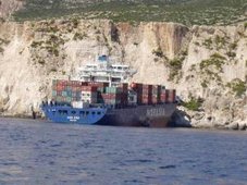
The Karlissa A and Karlissa B are being prepped like prize fighters.
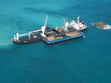
Titan Maritime’s two jack-up barges, which will serve as the work platforms for the removal of the shipwreck of the New Carissa, arrived from the Dominican Republic last Saturday. They have four to six weeks to work up the challenge. Round one is scheduled to start May 15.
Phil Reed, Titan’s director of engineering, hopes gloves will touch a bit sooner. His goal is to have the imposing barges with their gargantuan cranes and beach staging site ready by May 1.
All that will be left then will be the wait for good weather. Reed said Titan needs calm seas to take the barges out to the New Carissa stern, preferably swells of no more than 3 feet. The barges, once ready, will be docked at Sause Brothers Ocean Towing Facility in Empire to wait for perfect conditions.
“We are not going out there unless it’s a really nice day,” Reed said.
It wasn’t a nice day on Feb. 4, 1999, when the wood chip ship ran aground.
Nine years later, Titan gets to clean up the remains. The May 1 start date may be a little ambitious, considering how much work remains to be done.
The huge steel tubes out at Central Dock in Coos Bay are the legs of the barges. The giant tubes, each originally 150 feet long, were cut up for transport into three pieces — two 60-foot-long pieces and one 30 feet long. Crews will weld the two bigger pieces together to provide the needed height for the project. Each leg will be jammed 30 feet into the sand to stabilize the barges near the wreck. Putting the legs back together again is the biggest project on Titan’s to-do list in the next couple of weeks.
The Karlissa B’s 300-ton-capacity crane, nicknamed “Big Red,” is in the process of being repaired and repainted before installation on the barge. The other towering red crane at the dock next to the two barges will be placed on the Karlissa A.
Titan is using local businesses and resources for the prep work.
West Coast Contractors of Coos Bay helped put together the crane at Central Dock. Reed said Titan enlisted that crew to do more work on the barges.
“I’m just glad to be working at home right now,” Karlissa B crew member Jason Snelgrove said Thursday.
Snelgrove was working in Newport when the New Carissa’s bow ran aground near Waldport in March 1999, after the towline snapped as it was being pulled out to sea. He hasn’t been out to see the stubborn stern section yet, but may have the opportunity while working with Titan on the removal.
“However long they will have us, we will stay with them,” Snelgrove said.
Knutson Diesel and Machine is fabricating the 31-foot-tall tower that will connect the barges to the beach staging site, approximately 1,000 feet away from the New Carissa. The tower connection will be via an overhead cable car line. Crews and equipment will travel back and forth from the barges in the 6-ton-capacity car.
The staging area construction won’t begin until near the end of this month, after the last of the required temporary permits are issued. The staging area will include a temporary bypass road around the work area to allow alternate access to the North Spit.
Once work starts, the New Carissa will be taken apart a little bit at a time.
Deconstruction
Titan crews will cut up the vessel’s stern and remove the pieces using the cranes. Cutters will detach most of each piece of metal, but leave a 6- to 8-inch piece called a hanger so the cut can be secured to the crane. Once the pieces are rigged to the crane, the hanger will be cut and the metal transferred to one of the barges. Each piece will then be “flat packed,” cut to a size and shape that is easier to store on the deck. Reed said Titan intends to cut, process and store all the scrap metal on the barges until the job is done.
Crews will start working on the top of the wreck. Reed said that will be the easy part and may give onlookers the impression the job will be done fairly quickly.
“In the first couple of weeks, you will see a big difference,” he said. “The steel on top will be easy.”
Dealing with what is underneath, including the 250-ton main engine, will present the real challenge and take the most time. Still, Reed anticipates the work will be done well before the October deadline.
As crews work on the top portion, six pulling machines connected to the New Carissa by bulky anchor chains will pull on the wreck. Reed said the New Carissa may move right away under the pulling power or stay put until some of its bulk is hauled off. Pullers will progressively lift the New Carissa out of the sand.
“We are actually going to bring the bottom to us, rather than go down and work in conditions that are near impossible to work with,” Reed said.
Titan’s contract with the state stipulates crews can leave the portion under the sand line, but Reed said Titan is aiming at leaving no portion behind.
“For us, that is harder,” Reed said “We would rather follow the plan.”
To slice the wreck off at the sand line, a diver would have to cut while in the surf, a process which can be dangerous and inefficient, Reed said. The movement of the surf will prevent an even cut and divers could possibly be injured in the process.
A summer work window was chosen because of the favorable weather, but if nasty weather strikes, crews shouldn’t be stalled completely. The barges should be secure, no matter what is thrown at them, Reed said. Strong winds could shut down the cranes and possibly the overhead cable car.
If wind does prevent use of the cranes, workers can work on cutting the scrap pieces to storable sizes or work on removing sand from the wreck.
“We won’t be completely shut down unless things get really bad,” he said.
Though the Titan’s plan includes being as weather-independent as possible, the New Carissa’s location does present unique challenges.
Reed, who has worked with Titan since 1993, first as a consultant and, since 2000, as a full-time project engineer, said he hasn’t worked in these particular conditions.
“This is first time I’ve been in such an active surf zone,” he said.
Titan has been following the attempts to haul off the New Carissa from when it first ran aground. He thinks using the stable jack-up barges may be the answer to the stuck stern. Titan crews have had experience with large wrecks and have worked in surf zones, but the question remains as to how quickly crews can work with both challenges.
“We’ve cut up wrecks bigger than this,” Reed said. “But not one sitting in the surf zone.”











![Validate my RSS feed [Valid RSS]](valid-rss.png)