 This is a very interesting story, which was brought to my attention by a mariner who reads my blog.
I was so impressed with it I sent it to Dr. Paul C. Liu of NOAA who also blogs under the name Freaque Waves. Dr. Liu had indeed blogged about the wave that hit Reunion Island on 13 May 2007, but had not seen the ESA Sat Photo's.
Since Dr. Liu's has already posted the story " Giant wave hits Réunion island. " on his site, read about it from a real pro on large waves.
Below is the story and satellite photos from the ESA on the same wave that hit Reunion Island..
"A giant 36ft. wave was caught by a satellite imaging radar when it thrashed the southern port of Saint Pierre, Reunion Island on Saturday evening sending piers crashing down and flooding homes along the coastline. Two fishermen were still reported missing after their boat capsized.
Thought to be only legendary but now a natural ocean phenomenon, not rare, but rarely encountered. Evidence from mariners’ claimed that disappearances and damages to large ocean vessels suggests they have occurred. This evidence was confirmed following measurements of a massive wave at the oil platform in the North Sea in 1995. which caused minor damage was inflicted on the platform, confirming that the reading was valid.
Researchers from the GKSS Research Centre, using data collected by ESA satellites, identified a large number of radar signatures that may be evidence for rogue waves. Further research verifies the method that translated the radar echoes into sea surface elevation.
Freak waves or rogue waves have been cited in the media as a likely source of the sudden unexplainable disappearances of many ocean vessels.
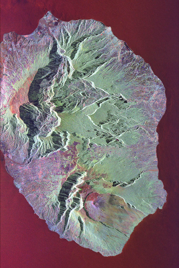
The animated image (above link) was acquired by the Spaceborne Imaging Radar-C/X-Band Synthetic Aperture Radar (SIR-C/X-SAR) aboard the space shuttle Endeavour on October 5, 1994. The image is centered at 21.2 degrees south latitude, 55.6 degrees east longitude. The area shown is approximately 50 km by 80 km (31 miles by 50 miles).
North is toward the upper right. Colors are assigned to different frequencies and polarizations of the radar as follows: red is L-band horizontally transmitted, vertically received; green is L-band horizontally transmitted, vertically received; and blue is C-band horizontally transmitted, vertically received. SIR-C/X-SAR, a joint mission of the German, Italian and United States space agencies, is part of NASA’s Mission to Planet Earth. Envisat is equipped with an advanced version of the SAR instrument, Advanced Synthetic Aperture Radar (ASAR), flown on the ERS-1 and ERS-2 missions.
Its wave mode acquires 10 by 5 km small images, or ‘imagettes’, of the sea surface every 100 km along the satellite orbit. These small ‘imagettes’, which depict the individual wave heights, are then mathematically transformed into averaged-out breakdowns of wave energy and direction, called ocean-wave spectra, which ESA makes available to scientists and weather centres."
Resources: European Space Agency -http://www.esa.int/esaCP/index.html
NASA
Weather Note;This video from the Weather Channel on Typhoon Man-Yi striking Japan.
"The typhoon sank a Chinese freighter 400 miles NW of Guam with 9 lost with the ship. Man-Yi would go on to bring Okinawa 105 mph wind gusts with major loss of power in Japan. The storm then crossed into Kyushu with 80-90 mph winds and flooding rains and more widespread power outages.
The storm's fury would injure 70 people and kill 5 on Kyushu. The typhoon weakened to a tropical storm but still brought 3-4 inches of rain to Tokyo and snarled train, plane, and car travel for several days. The system has now become extratropical and is moving rapidly away from the mainland with a threat only to shipping later today and tonight" (The Weather Channel).
We are also monitoring Tropical Storm COSME currently tracking for Hawaii.

RS


![[Valid RSS]](valid-rss.png "Validate my RSS feed")