Showing posts with label Typhoon 04W (Man-yi). Show all posts

Monday, July 30, 2007

China Thanks Horizon for Ocean Rescue

By ESTES THOMPSON 07.23.07, 5:21 PM ET

RALEIGH, N.C. Crew members of a ship operated by a North Carolina company were hailed by Chinese maritime officials for their "courageous, selfless and humanitarian" acts for braving typhoon-whipped seas to rescue two Chinese seamen from a sunken ship

One adrift man was plucked from the Pacific Ocean by a sailor harnessed to a 40-foot ladder as it was lowered into huge swells during Typhoon Man-yi. Thesecond man was rescued by a lifeboat that was heavily damaged, according to a log entry by the Horizon Falcon's captain.

The rescued men were among 13 surviving crew members of the 420-foot log carrier Hai Tong No. 7, which sank about 375 miles northwest of Guam earlier this month. The Panamanian-registered ship had a 22-member crew, according to the U.S. Coast Guard.

In a letter sent to Charlotte-based Horizon Lines (nyse: HRZ - news - people ) Inc., a Chinese government official thanked the Horizon Falcon crew and called the dramatic rescues "a demonstration of international humanitarian cooperation, mariner helps mariner."

The letter, dated July 17 and released by the company, was signed by Capt. Liu Gongchen, executive director general of the China Maritime Search and Rescue Center. An Associated Press correspondent in Beijing confirmed the letter's authenticity.

Crew members weren't available Monday because the ship was at sea, a company spokesman said.

Company officials said Capt. Tom McDorr steered the Horizon Falcon through logs and other debris to bring the 722-foot ship close enough to lower a lifeboat. One man was rescued by the lifeboat, driven by Kevin McCarthy, before it was abandoned after being damaged by an 18 to 20-foot swell.

Crew members pulled another Chinese seaman to safety after John Dacaug, who was strapped to a ladder, grabbed the man with a hook, according to the captain's log, which was released by Horizon Lines.

The Horizon Falcon and other ships searched for additional survivors, operating after sundown from the light of flares dropped by a Navy plane.

Horizon Lines Chairman Charles G. Raymond said the rescue was an example of "the brotherhood at sea that crosses any boundary."

Copyright 2007 Associated Press. All rights reserved. This material may not be published broadcast, rewritten, or redistributed

And from Horizon Lines;

Vessel in Force 8 North Pacific Ocean storm answers distress call

Charlotte, NC (July 17, 2007) – With 30-foot swells in fierce seas and with 40 mile an hour winds buffeting their efforts, the M/V HORIZON FALCON crew performed a rescue of two Chinese seafarers 375 miles northwest of Guam, Horizon Lines Inc. (NYSE:HRZ) reported today following a review of the FALCON’s Master’s Log. The rescue effort took place over a 24 hour period on July 12 and 13.

The HORIZON FALCON, a newly-constructed 2,824 TEU containership in the Horizon Lines fleet, responded to a request by the U.S. Coast Guard Sector Guam to divert for a distress call from a log carrier, HAI TONG No. 7. The 420-foot Panamanian-flagged ship had 22 Chinese crewmembers on board. It sank after encountering rough seas due to a typhoon in the area. Survivors were in the water for two days when the HORIZON FALCON arrived at the scene before noon on July 12.

Captain Tom McDorr of the HORIZON FALCON navigated rough seas strife with logs and other debris from the sunken ship to bring the 722-ft FALCON into safe recovery distance. The crew used a lifeboat and the ship’s portside pilots’ ladder to attempt a rescue of the distressed seafarers.

According to Captain McDorr’s log, a lifeboat with three seamen under the command of Chief Mate Kevin McCarthy, was dispatched with 18-20ft swells and waves impacting from every direction. One survivor was rescued, but as the lifeboat was being recovered, a large swell descended on the lifeboat, knocking the craft to a 45degree angle and damaging the motor. The crew was ordered to abandon the lifeboat and climbed to safety with the survivor up the containership’s 40 foot pilot’s ladder. A second survivor was rescued by ABS J. Dacaug, who while harnessed to the pilot’s ladder descended toward the water. While being submerged by swells, ABS Dacaug attached a grappling hook to the survivor before both were winched clear of the sea to safety.

With flares from an Okinawa-based Navy P3 Orion 225 airplane providing some light from above, the HORIZON FALCON continued searching for survivors and was eventually joined by the M/V CORAL EMERALD. The Horizon ship ran a search pattern in the area for four more hours until morning. A USCG Buoy Tender from Guam arrived at the scene to assist and relieve the HORIZON FALCON, which was running low on fuel.

The U.S. Coast Guard suspended the search operation for survivors of the HAI TONG No.7 on July 15 after 13 survivors of the 22-man crew had been rescued.


Weather Story

We are still tracking Invest 98L and now tracking Typhoon 05W (Usagi), heading for China.


RS

Tuesday, July 17, 2007

Reunion Island & Man-Yi

This is a very interesting story, which was brought to my attention by a mariner who reads my blog.

I was so impressed with it I sent it to Dr. Paul C. Liu of NOAA who also blogs under the name Freaque Waves. Dr. Liu had indeed blogged about the wave that hit Reunion Island on 13 May 2007, but had not seen the ESA Sat Photo's.

Since Dr. Liu's has already posted the story " Giant wave hits Réunion island. " on his site, read about it from a real pro on large waves.

Below is the story and satellite photos from the ESA on the same wave that hit Reunion Island..

"A giant 36ft. wave was caught by a satellite imaging radar when it thrashed the southern port of Saint Pierre, Reunion Island on Saturday evening sending piers crashing down and flooding homes along the coastline. Two fishermen were still reported missing after their boat capsized.

Thought to be only legendary but now a natural ocean phenomenon, not rare, but rarely encountered. Evidence from mariners’ claimed that disappearances and damages to large ocean vessels suggests they have occurred. This evidence was confirmed following measurements of a massive wave at the oil platform in the North Sea in 1995. which caused minor damage was inflicted on the platform, confirming that the reading was valid.

Researchers from the GKSS Research Centre, using data collected by ESA satellites, identified a large number of radar signatures that may be evidence for rogue waves. Further research verifies the method that translated the radar echoes into sea surface elevation.

Freak waves or rogue waves have been cited in the media as a likely source of the sudden unexplainable disappearances of many ocean vessels.

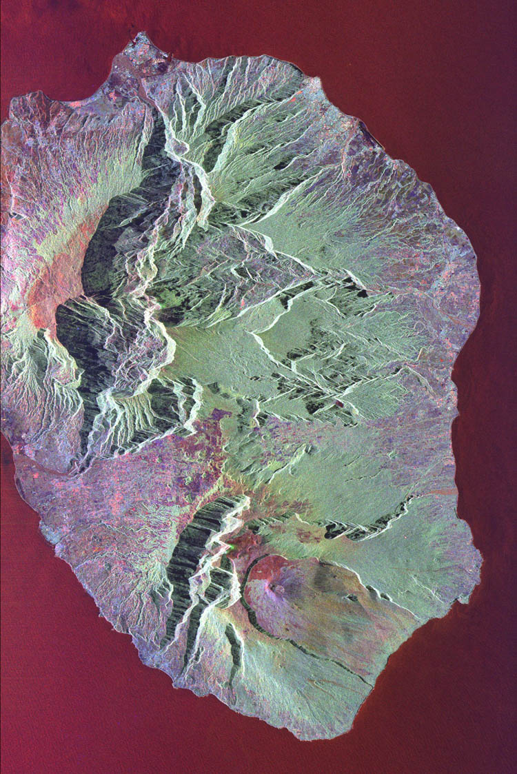
The animated image (above link) was acquired by the Spaceborne Imaging Radar-C/X-Band Synthetic Aperture Radar (SIR-C/X-SAR) aboard the space shuttle Endeavour on October 5, 1994. The image is centered at 21.2 degrees south latitude, 55.6 degrees east longitude. The area shown is approximately 50 km by 80 km (31 miles by 50 miles).

North is toward the upper right. Colors are assigned to different frequencies and polarizations of the radar as follows: red is L-band horizontally transmitted, vertically received; green is L-band horizontally transmitted, vertically received; and blue is C-band horizontally transmitted, vertically received. SIR-C/X-SAR, a joint mission of the German, Italian and United States space agencies, is part of NASA’s Mission to Planet Earth. Envisat is equipped with an advanced version of the SAR instrument, Advanced Synthetic Aperture Radar (ASAR), flown on the ERS-1 and ERS-2 missions.

Its wave mode acquires 10 by 5 km small images, or ‘imagettes’, of the sea surface every 100 km along the satellite orbit. These small ‘imagettes’, which depict the individual wave heights, are then mathematically transformed into averaged-out breakdowns of wave energy and direction, called ocean-wave spectra, which ESA makes available to scientists and weather centres."

Resources: European Space Agency -http://www.esa.int/esaCP/index.html

NASA

Weather Note;

This video from the Weather Channel on Typhoon Man-Yi striking Japan.


"The typhoon sank a Chinese freighter 400 miles NW of Guam with 9 lost with the ship. Man-Yi would go on to bring Okinawa 105 mph wind gusts with major loss of power in Japan. The storm then crossed into Kyushu with 80-90 mph winds and flooding rains and more widespread power outages.

The storm's fury would injure 70 people and kill 5 on Kyushu. The typhoon weakened to a tropical storm but still brought 3-4 inches of rain to Tokyo and snarled train, plane, and car travel for several days. The system has now become extratropical and is moving rapidly away from the mainland with a threat only to shipping later today and tonight" (The Weather Channel).

We are also monitoring Tropical Storm COSME currently tracking for Hawaii.

http://www.ssd.noaa.gov/goes/flt/t7/vis.jpg


RS

Monday, July 16, 2007

M/V Ital Florida

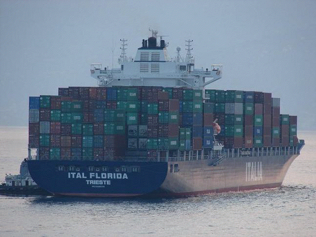
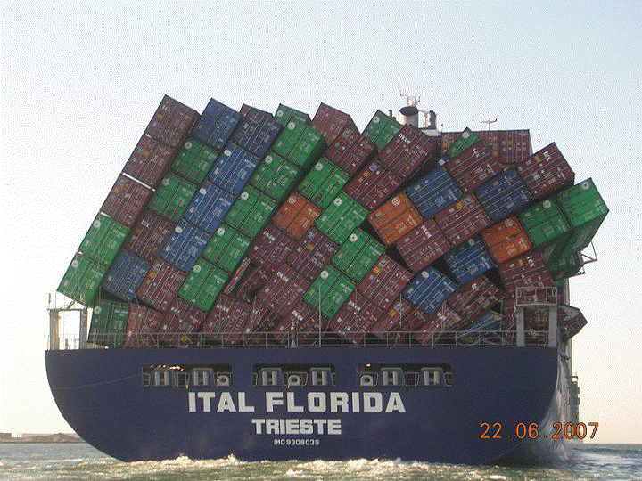
Once again mother nature can generate some powerful storms and waves. These waves can do a lot of damage to cargo and the vessel itself. As they say, pictures are worth a thousand words. Here (left) we have a picture of the container ship M/V Ital Florida on her maiden voyage departing port and below, the aftermath of mother nature at sea.

According to Cargolaw, the M/V Ital Florida made her maiden call at Hong Kong on April 20 2007. But the beginning of a busy career was interupted by a "Stack Attack" between June 16 & 19 2007.

This is the brand new Italian flaged container ship
M/V Ital Florida, particulars include: Length: 238.9 Meters (783.7 ft). Draft: 12.03 meters (39.4 ft). Gross ITC Tonnage -36,483.00 tons

The M/V Ital Florida lost at least three fully loaden containers in severe seas between June 16 & 19 in the Arabian Sea. The ship faced wave heigths of 7-10 m height (22 to 32 Ft). The M/V Ital Florida was running with almost 16 knots. The ship's deck also suffered storm damage.

=


The question that is being asked?.
Was this problem the result of improper lashing securing, bad weather or both? Many times improper lashing of the containers on deck plays a major role in loss of cargo during a storm. However this 783 foot containship is evidence that when mother nature roars "Ship Happens".

Now imagine a 44 foot sailboat like the s/v Sean Seamour II or any sailboat taking waves like this?

Weather Note:

On Saturday, 14 July 2007
Typhoon Man-yi struck southern Japan injuring 34. As reported by the AP. This powerful storm is also responsible for the sinking of a 420-foot cargo ship owned by Fuzhou Haijing Shipping, which was en route from Papua New Guinea to China when the cargo began shifting as the vessel encountered 70 mph winds and 24-foot seas from the typhoon. The number of survivors among the 22-member crew rose to 13, with eight receiving medical attention and 3 found dead in the U.S. territory about 3,700 miles southwest of Hawaii.

The Coast Guard cutter Sequoia arrived on scene Friday 13 July 2007 to coordinate operations as the air and sea search continued for the remaining six crew missing members. About 100 square miles had been searched, the AP reported.

RS


Friday, July 13, 2007

Subsea Atmospheres

We have talked about rogue and freak waves often on this blog. While these type of wave patterns are still under study, much is still unknown about them. It is my belief that these type of waves can be generated by subsea environments or storms that we still really do not know much about. We talk about chasing tornados and the hurricanes. But know anyone who chases underwater storms?

So, I am going to start a series of discussions, post articles and reports on subsea atmospheres and introduce you to a different type of storm chaser, "Oceanographers".

As I have stated before, we have a tendency to view things on a one plane thought process, namely, we process things as we "see" them. Much of what happens throughout the weather story we still do not see directly, yet. Moreover, science has been studying subsea or underwater atmospheres or storms, also known as, "
Benthic Storms" for some time now. Maybe one day we will have ocean study as a national priority.

Much of our weather I believe, actually is generated by weather patterns not just by surface atmospheres, but also by weather patterns created by subsea attmospheres and environments. Basically, the ocean has its own weather system, with winds and underwater storms that we never hear about or even see. . Oceanographer Dave Gallo from the Woods Hole Oceanographic Institute describes how much more there is going on in the ocean than we think.

According to Gallo, "
70 % of the planet, 95% of the biosphere, there are the highest mountains, the deepest valleys, the largest waterfall. There are more animals in the sea than on earth. 99% of the heat on the planet that comes from the sun is stored in the top few tens of feet of the ocean. It has everything the atmosphere has and more, it has everything that the land has and more and yet it's hardly explored, we've really seen less than 1% of what's out there.

Something oceanographers didn't expect were underwater storms. During a recent research mission to the deepest and darkest part of the ocean where things were thought to be quite stable - patterns from sediment samples showed disruptions as if a storm had ripped through.

There's a large mass of either sediments and/or water moving usually with gravity downhill or moving with currents across the sea floor. They can be fairly vicious.

An underwater storm can also cause damage on land, although indirectly. Back in the early 1900's a storm ripped across the sea floor and snapped northeastern transatlantic cables. The ocean has weather very similar to the atmosphere with high and low-pressure systems, clear days, and cloudy days:

The same kinds of things we see on the weather channel we see in the ocean and yet these things operate apart from the atmosphere.

Just like predicting the weather on land, underwater predicting is difficult as well. It's still an unfamiliar world."

Understanding subsea environments and being able to forecast subsea storms, as we do surface storms today, may not just answer many questions we do not understand about our oceans, but answer the question, where do freak or rogue waves come from? Hopefully benefiting mariners with advanced warning of dangerous SWH's or waves and more importantly save lives, cargo and ships.

Lets start with the basics, the physical and chemical make up of the oceans, with a paper titled, The Blue Planet,.

Weather Note;

Typhoon MAN-YI late yesterday became a Super Typhoon or a CAT-5 Hurricane as it struck the "Rock" and is tracking for Japan.

"The eye of Man-Yi was 189 kilometers from the city of Naha on the main island of Okinawa at 5 p.m. Japanese time today, the Japan Meteorological Agency said on its Web site. The storm is moving north across open water at 30 kilometers per hour after crossing Okinawa prefecture, which has a population of 1.4 million people.

The meteorological office said Man-Yi is ``extremely strong'' and issued warnings of gales, heavy rain, high waves and a tidal surge throughout Okinawa, the location of the biggest American airbase outside the U.S., and parts of Kyushu island to the north. National broadcaster NHK said areas of Miyazaki prefecture in Kyushu were flooded, and showed images of cars blown over and downed power lines. Bloomberg News."

Chicago weekend weather? Breath taking!

Have a really great weekend!

RS


Thursday, July 12, 2007

Okinawa braces for Typhoon 04W (Man-yi)

My second and important weather story of the day. Its been quiet in the Atlantic ( with exception of the storm at the NHC) but the Pacific is blowing a wind. That storm has been designated Typhoon Man-Yi (04W).

As of this morning, Typhoon Man-Yi (04W) was centered near 22 north and 128.5 east. Its winds were sustained at around 145 mph, and was tracking movement to the north-northwest at 15 mph, putting it at a strength very close to that of a category-4 hurricane.

The storm has the possibility of strengthening to a super typhoon (winds above 150 mph) very briefly Thursday afternoon, just before making landfall over Okinawa in the Ryukyu Islands by tonight. Waves are expected be greater than 35 feet, while a driving rainfall and strong, dangerous winds will batter the region. Mariners need to avoid this storm and all residence of Okinawa and the general area should take precautions prior to the arrival of this dangerous storm.


Here are the details from the Joint Typhoon Warning Center Typhoon 04W (Man-Yi)

RS