 ScienceDaily (Jan. 26, 2008) — Ocean surface currents have long been the focus of research due to the role they play in weather, climate and transportation of pollutants, yet essential aspects of these currents remain unknown.
 By employing a new technique – based on the same principle as police speed-measuring radar guns – to satellite radar data, scientists can now obtain information necessary to understand better the strength and variability of surface current regimes and their relevance for climate change.
Scientists at the SeaSAR 2008 workshop held this week in ESRIN, ESA's European Centre for Earth Observation in Frascati, Italy, demonstrated how this new method on data from the Advanced Synthetic Aperture Radar (ASAR) instrument aboard ESA’s Envisat, enabled measurements of the speed of the moving ocean surface.
Synthetic Aperture Radar (SAR) instruments, such as ASAR, record microwave radar backscatter in order to identify roughness patterns, which are linked to varying surface winds, waves and currents of the ocean surface. However, interpreting radar images to identify and quantify surface currents had proven very difficult.
By using the new information embedded in the radar signal – the Doppler shift of the electromagnetic waves reflected from the water surface – Dr Bertrand Chapron of the French Research Institute for Exploitation of the Sea (IFREMER), Dr Johnny Johannessen of Norway’s Nansen Environmental and Remote Sensing Centre (NERSC) and Dr Fabrice Collard of France's BOOST Technologies were able to determine how surface winds and currents contribute to the Doppler shift.
The Doppler shift occurs due to changing relative velocities, experienced in everyday life in the way the pitch of a siren on a passing ambulance goes up as it approaches, then goes down as the vehicle recedes away.
The shift is introduced by the relative motion between the satellite platform, the rotation of the Earth and the velocity of the particular facets of the sea surface from which the SAR signal scatters back to orbit. The initial two values are well known – particularly for Envisat, with its very stable satellite orbit and attitude – and can be simply subtracted to extract the useful sea surface velocity information.
Chapron first demonstrated the concept in 2005 with initial tests carried out over the Gulf Stream. Although the results were promising, repeat acquisitions and careful validation were not possible. However, based on these conclusions ESA upgraded its ASAR ground segment in July 2007 to systematically process and disseminate a Doppler grid product, a regularly spaced collection of individual Doppler information, for all Wide Swath acquired images.
The Doppler grid, embedded in ESA standard products, is now regularly tested on a number of so-called super-sites, including regions of the Gulf Stream and the greater Agulhas Current, both among the strongest western boundary currents of the world’s oceans.
"These measurements are very useful for advancing the understanding of surface current dynamics and mesoscale variability, as well as for determining surface drift, important for oil dispersion and pollution transport and for wave-current interaction, probably influencing the existence of extreme waves," Johannessen said.
"The method at this very high resolution could also complement the use of additional information sources to improve 3-D ocean models. Its use for sensor synergy with radiometry, spectrometry and altimetry is very promising," Chapron added.
The ground segment upgrade is also allowing the scientists to examine the anticipated Doppler shift signal of the river outflow at the mouth of the Amazon delta to monitor river runoff and improve our understanding of hydrological processes.
Chapron and Collard also presented their Near Real Time global swell wave observations to the workshop, attended by 150 participants from 25 countries. Using standard processed SAR ESA wave mode products, the team produces three hourly animations every morning for the Atlantic, Pacific and Indian Oceans and makes them available online.
Tracking swell waves from space is very important because they are generally preceded by calm water, making it impossible to detect their arrival from shore. Envisat’s Wave Mode acquires 10 by 5 km small images, or 'imagettes', of the sea surface every 100 km along the satellite orbit. These small images, which depict the wave groups, are then mathematically transformed into wave energy and direction, called ocean-wave spectra.
ESA has provided SAR data to some 500 oceanography projects since 1998 and remains committed to providing continuity to its SAR missions. As part of its Global Monitoring for Environment and Security (GMES) programme, the agency will launch the Sentinels – the first series of operational satellites responding to the Earth Observation needs of GMES, a joint initiative of the European Commission and ESA.
Sentinel-1, expected to be launched in 2011, will ensure the continuity of C-band SAR data with ESA's ERS-2 and Envisat satellites. Important applications driving the mission concept include marine - vessel detection, oil spill mapping and sea ice mapping. With these new findings, Sentinel-1 is expected to provide additional information, such as consistent wind, wave and current products.
Adapted from materials provided by European Space Agency.
NOAA DATABASE SUMMARYSPC Preliminary Severe Weather Database Summary
  |
  |
MARITIME ALERT
Maritime Accident Casebook
Confined Space Casualties - Worse Than Expected
By Bob Couttie
Early results of a study by the Maritime Accident Investigators International Forum, MAIIF, of accidents in confined spaces aboard ships suggest that the problem may be far bigger than anticipated. Despite decades of regulation and training, it's a problem that continued to
take the lives of seafarers at an alarming, and under-reported rate.
Still incomplete, the MAIIF figures report 44 deaths and 66 injuries in 63 incidents on ships of 15 Flag States since 1993. The data was supplied by the UK's MAIB and similar organisations in Vanuatu, Latvia, Cyprus, Marshall Islands and Germany. Figures for Hong Kong have yet to be included and more information has been promised by Sweden and South Africa and Finland.
In an email to MAIIF members, Don Sheetz of the Vanuatu administration, who has been tasked with gathering information for the report, says: "The information obtained so far is very troubling as the problem we originally identified may be even larger than anticipated."
A review of incidents already show that a confined space "may be any space, of any size, containing cargo, oil, water, petroleum, or nothing at all. A confined space may even be, as in the case of the fatality on the /Monika/ a cabin where a crewmember died," says Sheetz.
A new approach may be needed in defining a confined space. Says Sheetz: "It is apparent that the issue of confined space entry is not a single dimensional issue about entering a space which could be defined as a potential risk, but a multi-dimensional one where any space could, by virtue of its cargo, lack of oxygen, use of toxic chemicals, gaseous atmosphere, inerting, etc., cause death or injury, either shortly after the person enters or even several hours later. And the space could be a tiny lazarette, a battery room, a diesel engine cylinder, a boiler, a paint locker, an access way, a cargo hold, a cargo tank, a pump room, a chain locker, a fore peak or after peak tank, void spaces, fish meal processing rooms, the carpenter's shop, etc. It could be small enough to permit access only to a person's head or it could be 100,000 cubic meters or more in size."
Bob Couttie, administrator of Maritime Accident Casebook, a maritime safety internet site at www.maritimeaccident.org http://www.maritimeaccident
Do you have experience of a confined space incident, an actual or close call incident, whether officially reported or not? Sharing that information through the Maritime Accident Casebook confidential report system might help save the lives of other seafarers. Your identity will remain confidential. The address is confidential@maritimeaccident
MARITIME NOTES
USCG – Cosco Busan ISPR
The US Coast Guard issued a press release announcing the availability of the Incident Specific Preparedness Review (ISPR) report on the response to the oil spill from the M/V COSCO BUSAN in San Francisco Bay on 7 November 2007. The report did not examine the causes of the spill, only the response thereto.
The major areas for improvement identified in the report include having more experienced personnel on duty or on standby; prompt communication with local officials and the public; and improved planning for training and utilization of volunteers offering assistance in the response effort. The report found that the actual response effort in this spill was quite good, but that the initial investigation and external relations were lacking.
The Coast Guard also published a Timeline showing the various notifications and response actions, as well as a Hindcast, showing the estimated movement of the spilled oil through San Francisco Bay and adjacent waters in the hours after the spill. Finally, the Coast Guard released a PowerPoint document that walks through some of the major points of the ISPR. (1/28/08)
Hole found in storm ship's side
NOTES FROM gCAPTAIN
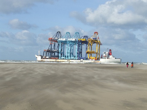
Beached In Rotterdam - Zhen Hua Heavy Lift Crane Ship
February 3rd, 2008
NOAA NEWS
Marine Safety Expert Now Heads NOAA Response Office
David Westerholm, a former chief of the U.S. Coast Guard's Office of Response, is the new director of NOAA's Office of Response and Restoration. He oversees the National Oceanic and Atmospheric Administration's preparation for and respond to environmental hazards caused by marine debris and oil/chemical spills in U.S. ocean and coastal waters.
"David Westerholm is an innovative and proven leader who has more than 30 years' experience heading and managing environmental, safety, security, and engineering programs," said John H. Dunnigan, NOAA assistant administrator for the National Ocean Service. "His expertise in preparing for and responding to oil spills and the release of hazardous materials will enhance NOAA's already strong response capabilities."
Before joining NOAA, Westerholm was VP and senior operations director for maritime security, policy, and communications with General Dynamics Information Technology, where he managed $17 million in contracts supporting federal and state customers in homeland security, emergency response, and strategic communications. While serving as a Coast Guard officer from 1976 to 2003, he worked in marine safety, homeland security, environmental compliance, and emergency planning and response roles. He has a master of science degree in environmental policy and planning from the University of Michigan.
RS


![[Valid RSS]](valid-rss.png "Validate my RSS feed")