@teamrobinstorm

According to NOAA’s Spring Outlook released today, rivers in half of the continental United States are at minor or moderate risk of exceeding flood levels this spring with the highest threat in the southern Great Lakes region due to above-average snowpack and a deep layer of frozen ground. Additionally, drought is expected to continue in California and the Southwest.
The continuation of winter weather, above-average snowpack, frozen ground and thick ice coverage on streams and rivers will delay spring flooding into April in the upper Midwest eastward to New England. The intensity of the flooding will depend on the rate of snow and ice melt, and future rainfall.
http://www.noaanews.noaa.gov/stories2014/20140320_springoutlook.html

NOAA, FEMA: Be a Force of Nature
National Severe Weather Preparedness Week March 2-8
February 28, 2014
During National Severe Weather Preparedness Week March 2 to 8, the National Oceanic and Atmospheric Administration (NOAA) and the Federal Emergency Management Agency (FEMA) are calling on individuals across the country to Be a Force of Nature: Take the Next Step by preparing for severe weather and encouraging others to do the same.
Just one tornado can cause catastrophic damage. Last year, the EF 5 tornado that struck Moore, Okla., on May 20 killed 24 people and caused more than $2 billion in damage. In 2013, a total of 903 tornadoes were reported in the United States. Those tornadoes occurred in 43 states on 152 days, resulting in 55 fatalities and more than 500 injuries.
National Severe Storm Preparedness Week


We are pleased to announce that Robin Storm is now a NOAA Weather-Ready Nation Ambassador™ !!!!!
Welcome to the NOAA Weather-Ready Nation Ambassador™ initiative. Your organization has been accepted as a NOAA Weather-Ready Nation Ambassador .

Research led by a University of Oregon doctoral student in California's Santa Cruz Mountains has uncovered geologic evidence that supports historical narratives for two earthquakes in the 68 years prior to San Francisco's devastating 1906 disaster.
The evidence places the two earthquakes, in 1838 and 1890, on the San Andreas Fault, as theorized by many researchers based on written accounts about damage to Spanish-built missions in the Monterey and San Francisco bay areas. These two quakes, as in 1906, were surface-rupturing events, the researchers concluded.
Continuing work, says San Francisco Bay-area native Ashley R. Streig, will dig deeper into the region's geological record -- layers of sediment along the fault -- to determine if the ensuing seismically quiet years make up a normal pattern -- or not -- of quake frequency along the fault.
Streig is lead author of the study, published in this month's issue of the Bulletin of the Seismological Society of America. She collaborated on the project with her doctoral adviser Ray Weldon, professor of the UO's Department of Geological Sciences, and Timothy E. Dawson of the Menlo Park office of the California Geological Survey.
The study was the first to fully map the active fault trace in the Santa Cruz Mountains using a combination of on-the-ground observations and airborne Light Detection and Ranging (LiDAR), a remote sensing technology. The Santa Cruz Mountains run for about 39 miles from south of San Francisco to near San Juan Batista. Hazel Dell is east of Santa Cruz and north of Watsonville.
Read > The rest of the story

Emergency management crews will have another tool to help them protect low-lying areas from flooding the next time a hurricane approaches.
Beginning this year, the National Hurricane Center's projections will include surge maps that show where flooding is expected along the Gulf and Atlantic coasts.
Flooding that usually accompanies a hurricane is caused by a storm surge -- a rise in ocean water caused by the atmospheric pressure and wind that pushes water landward. Storm surges can kill, with nine out of every 10 deaths from hurricanes caused by the surge or its flooding, according to Federal Emergency Management Agency statistics.
The surge maps, which will be experimental for at least two years, will be issued at the first sign of a hurricane or tropical storm watch and will be continuously updated with each new hurricane forecast, typically issued every six hours, according to a release from hurricane center's parent agency, the National Oceanic and Atmospheric Administration.
Read > The rest of the story...

The strongest trade winds have driven more of the heat from global warming into the oceans; but when those winds slow, that heat will rapidly return to the atmosphere causing an abrupt rise in global average temperatures.
Heat stored in the western Pacific Ocean caused by an unprecedented strengthening of the equatorial trade winds appears to be largely responsible for the hiatus in surface warming observed over the past 13 years.
New research published today in the journal Nature Climate Change indicates that the dramatic acceleration in winds has invigorated the circulation of the Pacific Ocean, causing more heat to be taken out of the atmosphere and transferred into the subsurface ocean, while bringing cooler waters to the surface.
"Scientists have long suspected that extra ocean heat uptake has slowed the rise of global average temperatures, but the mechanism behind the hiatus remained unclear" said Professor Matthew England, lead author of the study and a Chief Investigator at the ARC Centre of Excellence for Climate System Science.
"But the heat uptake is by no means permanent: when the trade wind strength returns to normal -- as it inevitably will -- our research suggests heat will quickly accumulate in the atmosphere. So global temperatures look set to rise rapidly out of the hiatus, returning to the levels projected within as little as a decade."
The strengthening of the Pacific trade winds began during the 1990s and continues today. Previously, no climate models have incorporated a trade wind strengthening of the magnitude observed, and these models failed to capture the hiatus in warming. Once the trade winds were added by the researchers, the global average temperatures very closely resembled the observations during the hiatus.
Read > The rest of the story..

Two University of Iowa researchers recently tested the ability of the world's most advanced weather forecasting models to predict the Sept. 9-16, 2013 extreme rainfall that caused severe flooding in Boulder, Colo.
The results, published in the December 2013 issue of the journal Geophysical Research Letters, indicated the forecasting models generally performed well, but also left room for improvement.
David Lavers and Gabriele Villarini, researchers at IIHR -- Hydroscience and Engineering, a UI research facility, evaluated rainfall forecasts from eight different global numerical weather prediction (NWP) models.
During September 2013, Boulder County and surrounding areas experienced severe flooding and heavy rain resulting in fatalities, the loss of homes and businesses, and the declaration of a major disaster.
After the storms had subsided, Lavers and Villarini decided to examine how well some of the leading NWP models had done. As a constantly improving science, NWP involves integrating current weather conditions through mathematical models of the atmosphere-ocean system to forecast future weather. For their study, the researchers selected the actual rainfall forecasts made by eight state-of-the-art global NWP models for the period of the Colorado floods.
Read > Best weather forecasting models evaluated: Which one best predicted September 2013 Colorado floods?

There are new buoys – and is some cases virtual buoys – coming to a U.S. port near you. First seen in the port of Mombasa, Kenya almost two years ago, AIS-assisted buoys (Real AIS ATON) – physical buoys with an AIS transmitter installed – will be rolled out in select areas on an experimental basis by the U.S. Coast Guard.
These will be accompanied by both Synthetic AIS ATON – physical buoys overlaid with an AIS signal generated by a shoreside base station and Virtual AIS ATON – truly virtual buoys with no physical presence, which would be visible on an appropriately outfitted ECDIS, radar or computer.
Read > The rest of the story..

For years, strange underwater circular formations in the Baltic Sea have mystified residents. Some have thought that they were bomb craters, or created by fairies or aliens. Turns out, none of the above explanations is correct.
"It has nothing to do with either bomb craters or landing marks for aliens," said biologists Marianne Holmer from University of Southern Denmark and Jens Borum from University of Copenhagen in a statement. "Nor with fairies, who in the old days got the blame for similar phenomena on land, the fairy rings in lawns being a well known example."
Read > The Scientific Explanation Behind Underwater 'Fairy Circles'
http://www.underwatertimes.com/link.php?url=http://www.popsci.com/article/science/scientific-explanation-behind-underwater-fairy-circles

Climate researchers have made the world's temperature records available via Google Earth. The new Google Earth format allows users to scroll around the world, zoom in on 6,000 weather stations, and view monthly, seasonal and annual temperature data more easily than ever before. The move is part of an ongoing effort to make data about past climate and climate change as accessible and transparent as possible.

While much of the continental United States endured several cold snaps in January 2014, record-breaking warmth gripped Alaska. Spring-like conditions set rivers rising and avalanches tumbling.
This map depicts land surface temperature anomalies in Alaska for January 23–30, 2014. Based on data from the Moderate Resolution Imaging Spectroradiometer (MODIS) on NASA’s Terra satellite, the map shows how 2014 temperatures compared to the 2001–2010 average for the same week. Areas with warmer than average temperatures are shown in red; near-normal temperatures are white; and areas that were cooler than the base period are blue. Gray indicates oceans or areas where clouds blocked the satellite from collecting usable data.
A persistent ridge of high pressure off the Pacific Coast fueled the warm spell, shunting warm air and rainstorms to Alaska instead of California, where they normally end up. The last half of January was one of the warmest winter periods in Alaska’s history, with temperatures as much as 40°F (22°C) above normal on some days in the central and western portions of the state, according to Weather Underground’s Christopher Bart. The all-time warmest January temperature ever observed in Alaska was tied on January 27 when the temperature peaked at 62°F (16.7°C) at Port Alsworth. Numerous other locations—including Nome, Denali Park Headquarters, Palmer, Homer, Alyseka, Seward, Talkeetna, and Kotzebue—all set January records.
Read > http://m.earthobservatory.nasa.gov/IOTD/view.php?id=83032&src=fb

In 1959 the AMS published a tome that became the touchstone document for a generation. The Glossary of Meteorology served its purpose well. So well that a 41-member editorial board and over 300 labored for five years to ensure the quality of the expanded, refreshed second edition of that volume…in 2000.
A lot happened in the meantime in the atmospheric sciences, largely because this community emphatically does not update itself solely on 41-year cycles.
Read > http://blog.ametsoc.org/news/the-polar-vortex-meets-rapid-refresh/
The number of annual excess deaths caused by hot weather in England and Wales is projected to surge by 257% by the middle of the century, as a result of climate change and population growth, concludes research published online in the Journal of Epidemiology and Community Health.
The elderly (75+) will be most at risk, particularly in the South and the Midlands, the findings suggest.
The research team, from the London School of Hygiene and Tropical Medicine, and Public Health England, used time-series regression analysis to chart historic (1993-2006) fluctuations in weather patterns and death rates to characterise the associations between temperature and mortality, by region and by age group.
They then applied these to projected population increases and local climate to estimate the future number of deaths likely to be caused by temperature -- hot and cold -- for the 2020s, 2050s, and 2080s.
They based their calculations on the projected daily average temperatures for 2000-09, 2020-29, 2050-59 and 2080-89, derived from the British Atmospheric Data Centre (BADC), and population growth estimates from the Office of National Statistics.
Read > http://www.sciencedaily.com/releases/2014/02/140203191806.htm?utm_source=feedburner&utm_medium=email&utm_campaign=Feed%3A+sciencedaily%2Fearth_climate+%28Earth+%26+Climate+News+--+ScienceDaily%29

Enhance Fujita (EF) Scale Open Feedback Forum to be Held in Conjunction with American Meteorological Society Annual Meeting
On Monday, February 3rd, 2014 from 1pm - 4pm EST, the National Weather Service (NWS) will host an open discussion with the American Meteorological Society (AMS) community regarding the current Enhanced Fujita (EF) Scale for rating the strength of tornadoes. This discussion will serve to outline the strengths and deficiencies with the current EF-scale rating guidance, and solicit feedback and ideas from the weather community on how the rating process might be improved.
The need for this EF-scale Open Feedback Forum arose when the rating of the El Reno, OK tornado of May 31, 2013 occurred.
This forum will permit a broad discussion about questions and concerns related to the present day EF-scale process.
Should evolving sensing technologies, which may not measure tornado wind speeds at the surface be used in post storm surveys?
How can the NWS ensure the tornado rating process is consistent throughout the nation?
Should a standard be developed to strengthen the tornado rating process?
Is there a need to maintain calibration or other metadata information on research sensing systems that may supplement future post storm assessments?
How should tornadoes, which do not produce quantifiable damage to structures, be included?
Can supplemental observation information be included in the present day Storm Data construct? If so, what is an effective format to include this information?
Well folks Punxsutawney Phil saw his shadow - 6 more weeks!
According to the National Weather Service they say that...
Every February 2nd crowds gather at Gobbler's Knob, in Punxsutawney, Pennsylvania. A groundhog, Punxsutawney Phil, burrowed inside his heated simulated tree trunk, is about to thrust or be pulled into the limelight at about 7:25 am once again. The gates open at 3:00 a.m., followed by live entertainment, music and a pre-dawn fireworks display helps to ignite (hopefully not literally!) the crowd that has gathered in anticipation of Phil's forecast.
The awe-inspiring fireworks are set to lively music, which is just what the crowd generally needs on a cold rural Pennsylvania morning. Phil, and others like him, makes the most celebrated weather forecast of the year usually around the crack of dawn. Has spring sprung when Phil emerges from his burrow and doesn't see his shadow? Or should he scurry back into his burrow for six more weeks of winter weather if skies are clear and fair?
Groundhog Day has its origins in an ancient celebration of a point mid-way between the Winter Solstice and the Spring Equinox. Superstition has it that fair weather was seen as forbearance of a stormy and cold second half to winter.
The early Christians in Europe established the custom of Candlemas Day, when the clergy would bless candles and people would light them in each window of their homes to ward off the darkness of mid-winter.
But the legend of the February 2nd forecast also persisted, as captured in this old English saying:
If Candlemas be fair and bright,
Winter has another flight.
If Candlemas brings clouds and rain,
Winter will not come again.
Read the rest ... http://www.ncdc.noaa.gov/special-reports/groundhog-day.php


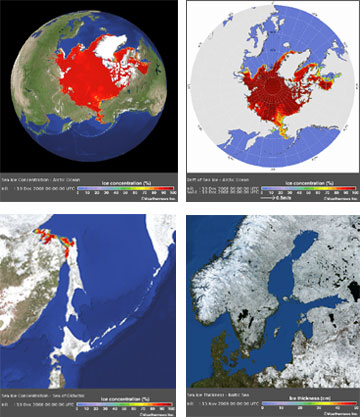 Weathernews launches Global Sea Ice Information website


 `
`








 `
`











































|


This site owned by Robin Storm at Robin Storm. |


![[Valid RSS]](valid-rss.png "Validate my RSS feed")


