Friday, November 7, 2008

Hurricanes Gustav and Ike Continue to Impact the Energy Infrastructure

Hurricanes Gustav and Ike Continue to Impact the Energy Infrastructure

Two months ago Hurricanes Gustav and Ike pounded the US Gulf Coast causing significant disruption to the nation’s energy infrastructure in Louisiana and Texas. Segments of our energy infrastructure impacted include:

  • drilling and exploration rigs
  • petroleum and natural gas production platforms
  • offshore-to-onshore petroleum and natural gas pipelines
  • natural gas processing stations
  • onshore petroleum and natural gas pipelines
  • petroleum refining system
  • petroleum product pipelines
  • electricity transmission system
  • electricity generation

Much has been learned about restoration from the Rita and Katrina experience of 2005. Folks working in the energy sector have performed heroically towards restoring a very complex energy system to meet demand from consumers, industry and government.

So how is the restoration effort progressing? Capstone Trading Advisors is tracking the cumulative US Offshore Gulf of Mexico production losses as reported by the US Minerals Management Service. As of 30Oct08, approximately 359.7 mbbl/day of crude oil and 2.4 Bcf/day of natural gas production continues shut-in. That equates to 27% and 33% of pre-storm production capacity, respectively. Within the last two months, cumulative production losses total 48.7 million bbls of crude oil and 253 Bcf of natural gas. See the charts below.
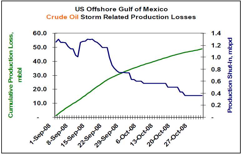
Lower petroleum product demand, and a corresponding reduction in refinery utilization, has cushioned the impact of this lost production. The key petroleum price drivers on a go-forward basis include 1) the depth of the global recession, 2) OPEC’s production response to lower crude oil prices, and 3) geopolitical events.

The deficit in US offshore GOM natural gas production has been made up via production from unconventional onshore sources including shale, coal bed methane and tight low-permeability formations. It is estimated that roughly 4.2 Bcf/day is being produced from these unconventional sources.

The US is expected to end the natural gas storage fill season at approximately 3.45 Tcf. The combination of storage and increased production from unconventional sources should be adequate for a normal winter season. A harsh, or early, winter could lead to significantly higher natural gas prices during the winter months. Weather is the wildcard for the natural gas market.

WEATHER NOTE

National Weather Service festival will unveil Oklahoma City Microne

NORMAN — A network of 40 weather-observing stations in Oklahoma City will be unveiled Saturday during the annual National Weather Festival in Norman.

The free festival, scheduled 9 a.m. to 1 p.m. at the National Weather Center on the University of Oklahoma research campus, also will feature hourly weather balloon launches, a storm chaser car show, a children’s activity area and a weather center open house.

The Oklahoma City Micronet dedication is scheduled for 10:15 a.m. The Micronet will have four Oklahoma Mesonet stations, along with 36 miniature weather stations installed on traffic signals throughout the city.

The Oklahoma Climatological Survey developed the Micronet in cooperation with OU and the city of Oklahoma City. The survey also runs the Mesonet, the system of more than 110 weather stations throughout the state.

Mesonet and Micronet stations record temperatures, wind speed and precipitation.

Past National Weather Festivals have attracted visitors from all over Oklahoma and other states.

The car show features vehicles ranging from weathered clunkers driven by amateur chasers to newer television-station vehicles with state-of-the-art technology.

Visitors also can see forecasters at work while touring the National Weather Center, said Keli Tarp, a spokeswoman for the National Oceanic and Atmospheric Administration’s Weather Partners.

Nearly Half of U.S. States Fail on Emergency Plan Communication, New Study Shows

ScienceDaily (Oct. 27, 2008)
— Seven years after Sept. 11, and in the wake of many major natural disasters such as forest fires, hurricanes and flooding, nearly half of U.S. states either have no state-level emergency plan or do not provide it readily to the public, reveals a new study by George Mason University Communication Professor Carl Botan.

Despite federal laws that require a state emergency operations plan (EOP) as a prerequisite to some federal funding, 22 states were unable to provide Botan with an EOP, withheld the plan on security grounds or made it difficult for even trained researchers to gain access. Residents of these states, Botan says, may question their state's preparedness because they are unable to find out how the highest authorities in their state coordinate responses to major disasters or how to have a say in those plans.

"While most Americans will have access to some important state-level information during emergencies, many may not. When minutes may make the difference between life and death in an emergency situation, the population should not have to waste precious time looking for answers or who to turn to," says Botan.

The study, "Using Sense-Making and Co-orientation to Rank Strategic Public Communication in State Emergency Operations Plans," graded and ranked the state emergency operations plans of the 50 U.S. states and the District of Columbia on their communication components.

Botan analyzed the accessible state EOPs for three criteria: if the plans had a two-way communication component, if they addressed the communication needs of vulnerable populations and if they treated public communication as important enough to specifically address it in the plan.

He found that the 29 jurisdictions that do have plans available make provisions for public communication-including news releases and public broadcasts, but only 16 of them make explicit or implicit provisions for two-way public communication such as community forums and focus groups. Botan feels that two-way public communication is essential in the plans, for that will allow the state to understand what its residents feel they need in emergency situations.

Of the 29 plans obtained, only two-Washington, D.C. [which is treated as a state-level entity for this purpose] and New Mexico-received a perfect score of eight for communication.

In addition, while 16 states mentioned vulnerable publics, only 13 of these discussed specific communication strategies for these vulnerable publics in their plans. For example, California mentions specific strategies such as dispatching special teams targeting vulnerable populations like the aged and the disabled, while Arizona simply mentions that emergency managers must pay attention to "special needs" people like residents of nursing homes and the hearing impaired, but does not outline specific strategies to communicate with them.

As of 1988, all states are required under the Stafford Disaster Relief and Emergency Assistance Act to have a written EOP in order to qualify for some federal funding. "Billions of tax dollars have been spent on homeland security in the last half-decade," Botan says. "It's very important that these plans are available to the public. Otherwise residents can't be confident their needs have been thought of, and aren't sure who they can count on."

The study, co-authored by George Mason University alumni Paul Penchalapadu, is to be presented at the National Communication Association annual conference in San Diego on Saturday, Nov. 22.


MARITIME NOTE

Coast Guard rescue swimmer injured during sinking sailboat rescue

PORTSMOUTH, Va. - Coast Guard rescue crews from six different units, including three Cutters and three Air Stations, responded to a sinking sailboat with three people onboard approximately 102 miles southeast of Atlantic City N.J., Wednesday.

Rescued were Kevin Hogan, a 52-year-old and Teresa Gravie, age unknown. Phil Rubright, a 65-year-old Detroit resident was recovered but pronounced deceased by the Atlantic County Medical Examiner Office in Atlantic City.

The Coast Guard began its search after watch standers at the Rescue Coordination Center in Portsmouth received an Emergency Position Indicating Radio Beacon (EPIRB) alert and determined it was aboard the 44-foot sailing vessel FREEFALL.

After obtaining this information Coast Guard rescue crews, aboard a C-130J and MH-60 Jayhawk helicopter were launched from Coast Guard Air Station Elizabeth City, N.C.

The Elizabeth City rescue crews arrived on scene but were unable to hoist the three passengers from the FREEFALL due to the extreme weather conditions consisting of rain and 40-50 knot winds and 40-50 foot seas. The rescue crew determined that in order to conduct a safe hoist the passengers and the rescue swimmer had to enter the water. The rescue swimmer and Mr. Rubright entered the water to attempt the hoist but the rescue basket and hoist cable were damaged by a large wave.

The helicopter crew deployed a life raft and Mr. Rubright was placed in it. Reportedly another large wave hit and injured the rescue swimmer and tossed Mr. Rubright from the life raft. The injured rescue swimmer was unable to recover Mr. Rubright.

The helicopter crew employed the Emergency Recovery Device (ERD) to recover the rescue swimmer. This manual recovery device is only used during the most extreme circumstances and the person being hoisted must be trained and wear a rescue strop.

Without the means to recover Mr. Rubright the helicopter crew called for assistance and departed for Atlantic City to seek treatment for the injured rescue swimmer.

The Coast Guard then launched two MH-65 Dolphin rescue helicopter crews from Air Station Atlantic City along with a HU-25 Falcon jet and a MH-60 Jayhawk helicopter crews from Air Station Cape Cod, Mass. The 270-foot Coast Guard Cutters Northland and Seneca, along with the 87-foot Coast Guard Cutter Mako were also dispatched to the scene.

The Atlantic City helicopter crews were able to relocate the stricken vessels crew and relay the position to the incoming Cape Cod rescue crews.

Upon arriving on scene the Cape Cod helicopter crew recovered Mr. Rubright from the water and flew him to Atlantic City where he was pronounced deceased by the Atlantic County Medical Examiner.

A second MH-60 Jayhawk rescue helicopter crew from Elizabeth City was dispatched to the scene and hoisted Hogan and Gravie from the sailboat and flew them to Air Station Atlantic City where they were turned over to local EMS crews and taken to a AtlatiCare Regional Medical Center in Atlantic City for treatment.

Both Hogan and Gravie suffered from mild hypothermia and are in good condition.

This case is under investigation by the Coast Guard.

Salvors Rescue Grounded Containership with Hazardous Cargo on Board

NETHERLANDS-based towage and salvage specialist Multraship and Belgian salvage operator URS Salvage & Maritime Contracting have refloated the 39,900 gt, Singapore-flag containership Kota Lagu, which grounded in the River Scheldt with hazardous cargo on board on October 25.

The 2006-built vessel grounded after suffering rudder failure near Ossenisse on the River Scheldt, between Hansweert and Antwerp, during ebb tide. Working under a Lloyd’s Open Form agreement, Multraship and URS immediately mobilised an experienced salvage team and six tugs. The salvors tried to refloat the vessel on the same tide, but the water level had fallen too far and the operation had to wait for the next tide, at around midnight.

Because the vessel had hazardous cargo on board, local authorities declared a ‘High Alert’ situation, and the salvors accordingly made provision for a potential major incident by mobilising further tugs, salvage professionals, booms, pumps, and lighters for bunker discharge. In the event, eight tugs were able to refloat the vessel on the next tide and subsequently towed it to the Scheldepoort yard at Flushing, where it was redelivered to its owners.

Leendert Muller, managing director of Multraship, says, “This was another incident which served to illustrate the essential nature of the professional salvage industry, and the importance of having immediate access to its resources and expertise. Working closely with the local authorities, we were able to avert a potentially catastrophic outcome, given the presence on board the vessel of hazardous cargo.”

Peter Vierstraete, general manager of URS, adds, “The fact that we were able to refloat the vessel on this occasion without major incident should not disguise the continuing need to ensure that the resources are available, and in position, to deal with such emergencies.



Messing About In Ships Podcast


Have a wonderful weekend...

RS

Thursday, November 6, 2008

Hurricane Ike Caused Underwater Damage To Galveston

Hurricane Ike Caused Underwater Damage To Galveston

ScienceDaily (Oct. 30, 2008) — Conducting a rapid response research mission after Hurricane Ike, scientists at The University of Texas at Austin surveyed the inlet between Galveston Bay and the Gulf of Mexico, discovering the hurricane significantly reshaped the seafloor and likely carried an enormous amount of sand and sediment out into the Gulf.

The ongoing research could help coastal communities gauge the effectiveness of their sometimes controversial efforts to replenish eroding sand along shorelines while revealing the role storms play in building and eroding barrier islands such as Galveston.

“The big question is whether the sand was entirely removed from the system or if it’s still close enough to the shoreline to get back into the system,” said John Goff, survey team member and senior research scientist at the university’s Jackson School of Geosciences.

Goff and Mead Allison, another research scientist at the Jackson School, used the 60-foot research vessel R/V Acadiana to conduct a seafloor survey of the Bolivar Roads inlet just a week and a half after Hurricane Ike made landfall on the Texas coast. The inlet is the main passage between the Gulf of Mexico and Galveston Bay and is the route of the Houston Ship Channel as it passes between Galveston Island to the west and the Bolivar Peninsula to the east. The team used sonar to map the depth of the seafloor and seismic instruments to measure the thickness of sediments.

The researchers knew the area well having led a group of university students on a marine geology and geophysics field class to Galveston this summer, collecting the most recent pre-Ike seafloor mapping and sample data from Bolivar Roads.

“The timing of our previous study was fortuitous,” said Goff, “adding to the practical and public benefit of our post-Ike data.”

Hurricane Ike’s surge last Sept. 13 filled Galveston Bay with 12 feet of water, which subsequently drained back into the ocean as a “back surge.” Although considerable amounts of water flowed over the Bolivar Peninsula and other lower-lying portions of the barrier system, most of the surge and back surge likely passed through Bolivar Roads, by far the deepest access between the Gulf and the Bay. The very high rate of flow that must have passed through the inlet had the potential to cause substantial erosion and transport sediment long distances.

Comparing pre- and post-Ike surveys, the scientists determined the hurricane’s surge and back surge significantly modified the seabed over broad areas. Ike either erased or substantially degraded large shell-gravel ridges up to 10 feet high. The storm gouged out sediments deposited hundreds of thousands of years ago to create “erosional pits” up to five feet deep in one area. It appears to have mobilized and redeposited sediments over large regions in a layer eight to 40 inches thick, and in isolated spots up to 6.5 feet thick. Most of the movement of sediments is associated with the back surge.

In conducting their post-Ike survey, the scientists are primarily interested in investigating the impact of the storm surges on the movement of sediment into and out of the beach barrier system. Maintenance of a barrier system requires an influx of sand, provided naturally by rivers such as the Mississippi. Human modifications to rivers by dams or levees disrupt the delivery of sand to the shore, which can cause the barrier system to degrade.

Until now, the transport of sediments during large storms was a poorly known quantity. Surges could potentially boost the barrier island sand budget by delivering sediments to the shore face, or they could subtract from it by moving sand too far off shore to be incorporated into the barrier system. The pre- and post-Ike survey work will also identify any storm-affected changes to the inlet channel that could affect navigation.

Weather permitting, the team will conduct an additional survey Nov. 6-8 offshore of Bolivar Roads to identify the extent of storm-related deposition, and offshore of the Bolivar Peninsula, where aerial and satellite photos suggest significant amounts of surface erosion during the back surge and consequential deposition off shore. Jackson School researcher Sean Gulick will also participate in this extended effort.

Funding for the survey was provided by the Jackson School’s Rapid Response Program, which funds field research requiring immediate action, in advance of the months it often takes to receive federal or non-profit grant money. Such projects include research into the effects of natural disasters like sinkholes, hurricanes, earthquakes and tsunamis.

WEATHER NOTE

2008: A record year for tornadoes

BIRMINGHAM, Ala. (AP) - Its been a record year for tornadoes in Alabama, so says the National Weather Service.

According to meteorologists, mother nature spawned 78 twisters through August of this year.

That breaks a previous record of 77 tornadoes in 2005.

The dangerous storms were responsible for five fatalities and 70 injuries statewide.

NWS said the worst tornado outbreak in 19 years occurred Feb. 6 when two violent EF4 twisters touched down in the Tennessee Valley.

The highest number of injuries occurred Feb. 17 when two strong tornadoes touched down near Prattville and were on the ground for 25 miles.

On the Web: www.spc.noaa.gov

GSA Launches Program to Support State and Local First Responders

State and local governments have a new way to buy supplies and services to prepare for and respond to all types of emergencies under a program established by the U.S. General Services Administration (GSA) earlier this month.

The Cooperative Purchasing Program allows state and local agencies to buy law enforcement, security, and first responder goods and services off a GSA contract known as Schedule 84. The interim rule implements the Local Preparedness Acquisition Act, signed by President Bush on June 26, 2008.

“Access to Schedule 84 will help our state and local government partners make their communities safer today,” said GSA Acting Administrator Jim Williams.

The GSA Cooperative Purchasing Program was started in 2003 to allow state and local governments to procure information technology equipment, software, and services found under Schedule 70 and Consolidated Schedule contracts containing IT Special Item Numbers. Under the expanded Cooperative Purchasing Program, state and local governments can also buy total solutions for law enforcement, security, facilities management, fire, rescue, clothing, marine craft and emergency/disaster response equipment.

As individual Schedule 84 vendors agree to participate in the program, a blue over red (COOP/PURCH) icon will appear next to their company name and the products/services displayed in GSA E-library and GSA Advantage. In addition, state and local agencies can purchase products and services from Schedules 70 and 84 under Cooperative Purchasing from GSA Advantage.

MARINE NOTE

NTSB Determines High-Risk Maneuver Caused 2007 Baton Rouge Marine Accident

Thursday, October 30th, 2008

Washington, DC (October 30th 2008): The National Transportation Safety Board has determined that the probable cause of the M/V Kition's collision with the Interstate Highway 10 bridge in Baton Rouge, Louisiana, was the pilot's attempt to execute the high-risk maneuver of turning at the dock immediately above the bridge rather than moving the vessel downriver through the bridge before turning, or taking it well upriver, then turning.

"This accident involving a large ship carrying a load of carbon black (a petroleum product) striking a highway bridge could have been catastrophic," said NTSB Acting Chairman Mark V. Rosenker. "It is imperative that we make sure that an accident like this does not happen again."

On February 10, 2007, the Kition, a Bahamas-registered tankship, was scheduled to depart Port Allen, Louisiana, on the Mississippi River. A state-licensed pilot, as required by Louisiana law, and three tug boats were on-hand to move the nearly 800-foot-long vessel away from its berth at the Apex Oil terminal and turn the vessel around to head downriver. The state pilot directed the movements of the Kition and issued all orders to the tugs. During the maneuver to turn the vessel down river from the dock, its starboard bow struck the bridge pier, knocking out a section of concrete and severely damaging the bridge fenders. There were no injuries or pollution and the accident did not affect the safety of the bridge. However, the vessel did sustain damage to its hull.

"Proper training would have prevented this accident." Rosenker said.

As a result of this accident, the Safety Board made the following recommendations:

• To the Board of New Orleans-Baton Rouge Steamship Pilot Examiners for the Mississippi River:

1. Verify that the pilots assigned to challenging locations such as the Apex dock have received adequate training in docking and undocking large vessels at such locations.

• To the United States Coast Guard:

2. Retrain your investigating officers in the policy set forth in ALDIST 174/97 regarding postaccident drug testing by Coast Guard personnel.

3. Verify whether the regulations for alcohol testing after serious marine incidents are being followed, and if not, identify corrective measures.

The Board's report can be found on its website at the following link: http://www.ntsb.gov/publictn/2008/MAR0803.pdf

NTSB Reference: SB-08-50

Forty-two dead, nine missing following Philippine ferry accident

MANILA (AFP) — The death toll from a ferry accident in the central Philippines rose to 42 Wednesday with nine people still missing, officials said.

The wooden inter-island ferry overturned Tuesday when it was hit by a freak whirlwind just 20 minutes after leaving port, where weather conditions were described as calm and clear.

Local civil defence chief Raffy Alejandro said the ferry was carrying 151 passengers and crew, well in excess of the 119 people listed on the manifest.

Of those on board, 100 have been rescued, 42 are dead and nine are still missing.

"This will be subject of an investigation by the coast guard since apparently it was overloaded," said Alejandro.

It is a common practice for inter-island ferries to be overloaded with last-minute passengers who board without being listed on the manifest.

The captain of the vessel, Dante Bumbales, has been found and turned over to coast guard officials investigating the incident, said local police chief Senior Superintendent Ruben Sindac.

The ferry had just left the port town of Dimasalang on the northeast coast of Masbate for Sorsogon port 80 kilometers (50 miles) away when it was hit by a sudden gust of wind and flipped over.

The accident came four months after the 23,000-tonne "Princess of the Stars" capsized during a typhoon off the central island of Sibuyan carrying 850 passengers and crew.

Only 57 people survived the accident, which was the worst maritime disaster in the Philippines for 20 years.

Mishaps involving ferries are common in this archipelago where many poor people rely on small, poorly-maintained vessels to travel between islands.

USCG – marine safety program independent evaluation

The US Coast Guard issued internal guidance stating that over the next four months an independent evaluation will be conducted of the agency’s Marine Safety and Marine Environmental Protection Program. In addition to examining a number of Coast Guard units, the evaluators will meet with various stakeholder organizations. ALCOAST 536/08 (10/28/08).


RS

Wednesday, November 5, 2008

Recent Hurricane History Provides Diverging Interpretations On Future Of Hurricane Activity

Recent Hurricane History Provides Diverging Interpretations On Future Of Hurricane Activity

ScienceDaily (Nov. 2, 2008) — In a paper published in the journal Science, scientists Gabriel A. Vecchi of NOAA's Geophysical Fluid Dynamics Laboratory, Kyle L. Swanson of the University of Wisconsin - Milwaukee Atmospheric Sciences Group and Brian J. Soden from the University of Miami's Rosenstiel School of Marine and Atmospheric Science teamed up to study hurricane data observed over more than 50 years.

The study explores the relationship between sea surface temperature (SST) and seasonal hurricane activity, and show how differing interpretations of the observational record can imply vastly different futures for Atlantic hurricane activity due to global warming. The two interpretations arise from assumptions of whether it is the local SST in the Atlantic in isolation, or whether it is the SST in the Atlantic 'relative' to the rest of the tropics, that drives variations in Atlantic hurricane activity.

If one assumes the former (the local SST hypothesis), then by 2100, the lower bound on Atlantic hurricane activity is comparable to that of 2005, when four major hurricanes struck the continental United States, causing more than $100 billion in damage. The upper bound exceeds 2005 levels by more than a factor of two. However, if one assumes the latter (the relative SST hypothesis), then the future is similar to the recent past, with periods of higher and lower hurricane activity relative to present-day conditions due to natural climate variability, but with little long-term trend.

The statistical relationship between either interpretation of the SST/hurricane activity link is ambiguous over the period 1946-2007 (they are statistically indistinguishable, though both are significant), but they imply fundamentally different projections for the future and interpretations of the past. The team further argues that the consistency between theory, numerical models, and historical observations offers compelling evidence that the 'relative' SST hypothesis is more accurate and provides a better framework for projections of future changes in hurricane activity.

WEATHER NOTE

Massive waves a mystery at Maine harbor

Dockworker Marcy Ingall saw a giant wave in the distance last Tuesday afternoon and stopped in her tracks. It was an hour before low tide in Maine's Boothbay Harbor, yet without warning, the muddy harbor floor suddenly filled with rushing, swirling water.

In 15 minutes, the water rose 12 feet, then receded. And then it happened again. It occurred three times, she said, each time ripping apart docks and splitting wooden pilings.

"It was bizarre," said Ingall, a lifelong resident of the area. "Everybody was like, 'Oh my God, is this the end?' " It was not the apocalypse, but it was a rare phenomenon, one that has baffled researchers. The National Weather Service said ocean levels rapidly rose in Boothbay, Southport, and Bristol in a matter of minutes around 3 p.m. on Oct. 28 to the surprise of ocean watchers. Exactly what caused the rogue waves remains unknown.

"The cause of it is a mystery," said National Weather Service meteorologist John Jensenius, who first reported the waves from a field office in Gray, Maine. "But it's not mysterious that it happened."

Specialists have posed a variety of possible explanations, saying the waves could have been caused by a powerful storm squall or the slumping of mountains of sediment from a steep canyon in the ocean - a sort of mini tsunami. The last time such rogue waves appeared in Maine was at Bass Harbor in 1926.

Jensenius said the occurrence is so unusual, that specialists don't have a name for the phenomenon.

"That's part of our problem," he said.

A similar occurrence in Florida more than 15 years ago continues to baffle researchers. A series of 12- to 15-foot waves hit Daytona Beach on July 3, 1992, injuring more than 20 people and lifting and tossing dozens of cars.

Jeff List, an oceanographer at the US Geological Survey at Woods Hole said he and other researchers studied the occurrence, but no one has been able to pinpoint the cause. And he said similarly enormous waves appeared once on the Great Lakes.

Could such a wave or waves enter Boston Harbor, or even engulf the Massachusetts coast?

"It seems a little unlikely one could hit Boston," List said. "But then again, these things are always surprises when they occur."

A squall line surge, which occurs when fast-moving storm winds sweep over water that is traveling the same speed, can create such a wave. (The speed of waves is directly related to wind speed and the depth of the ocean at any given point.)

List and other specialists said such an occurrence is exceedingly rare, but when it occurs, "you get this interaction that causes a large bulge of water to rise up."

Jensenius said that might have been a factor last week, when a major storm front brought rain to most of the East Coast, particularly southern New England. But he said that does not solve the mystery, adding that he had not ruled out a massive "land slump" underwater. Such slumps can create waves that may be classified as tsunamis, although no where near the size and scale of the tsunami that occurred in the Indian Ocean in 2004. Those fast-moving and deadly waves were caused by a massive earthquake.

Tsunami-like waves may not be as rare on the East Coast as most people think. Jensenius referenced a 2002 article in the International Journal of the Tsunami Society that called the threat of tsunami and tsunami-like waves generated in the Atlantic Ocean "very real despite a general impression to the contrary."

The article said such waves appear "in most cases to be the result of slumping or landsliding associated with earthquakes or with wave action associated with strong storms."

Explosive decompression of underwater methane could also be a factor.

Jensenius said he is trying to gather information on the waves that hit Boothbay Harbor, adding that he has asked local businesses such as banks whether the event might have been recorded on security videos.

"It could be this or it could be that, but as a science, it is very difficult to tie it down," he said of the waves.

List also said the waves could have been triggered by the same conditions that cause a tsunami, including a breaking glacier. Rogue waves can result from a tsunami traveling through the ocean that breaks "down into numerous waves."

According to the National Weather Service, no earthquakes or seismic activity were reported in the area when the Boothbay waves appeared. List noted that there was no seismic reading when the Daytona waves struck.

Tom Lippmann, an oceanographer in the Marine Sciences Department at the University of New Hampshire, said he also suspected that the Maine wave was a squall line surge. The National Weather Service incorrectly called it a tide surge, he said.

"Tides in the Gulf of Maine are essentially driven by celestial bodies' pull on the earth's water," he said. "They're very well predicted and very well known."

Residents and business owners in Boothbay said they were glad the phenomenon didn't happen at high tide, when it might have caused massive flooding and more extensive damage. Janice Newell, who lives nearby in Head of the Harbor, told the local newspaper the rushing water "was of biblical proportion."

"There were three large whirlpools in the inner harbor, up to within a foot of my neighbor's wall," she told the Boothbay Register. "It was beautiful, but it was scary."

Elena Smith, a waitress and part-owner of McSeagull's restaurant overlooking the harbor, said the late-afternoon lunch crowd sat speechless as the waters rose and receded. She was stunned to see the normally safe and placid harbor suddenly run like rapids. Some residents reported seeing massive whirlpools of water that disappeared, leaving clam shells and seaweed in vortex patterns on the harbor floor.

"It felt like somebody took the plug out somewhere" in the ocean, Smith said. "It felt like there must have been water missing in the ocean someplace."

MARINE NOTE

Cosco Busan incident spurs search for safety

It was the mariner's worst nightmare - from the bridge of the container ship Cosco Busan, Capt. John Cota, the man who was in charge of navigating the vessel, could see one of the towers of the San Francisco Oakland Bay Bridge looming out of the fog.

He was headed right for it. The Cosco Busan is 901 feet long - longer than the Transamerica Pyramid is tall - and the ship's diesel engine, which generated 77,600 horsepower, was set on full speed ahead. There was no way to stop. Cota took quick evasive action, but the Cosco Busan sideswiped the tower, ripping a hole on the left side of the ship, spilling 53,000 gallons of heavy fuel oil that fouled miles of shoreline and killed nearly 3,000 birds.

That was a year ago this Friday.

The question is: Could it happen again?

"Absolutely," said Kelly Sweeney, a ship captain who writes a column for Professional Mariner magazine.

The main question is not how to prevent accidents - there will always be plane crashes and train wrecks, for example - but how to minimize the risks.

Experts say there are three ways: restrict operations of large ships in poor visibility, provide better tools to pilots, and construct better protections for the footings of bridges and other structures.

The Cosco Busan accident cost more than $90 million so far and Cota faces criminal charges in federal court. The accident also damaged the careers of several Coast Guard officers, and is likely to cost Regal Stone Ltd., which owns the ship, and Fleet Management Ltd., which operated it, millions of dollars.

There have been congressional hearings, and several investigations. A report by the National Transportation Safety Board and the Coast Guard into the cause of the accident is due in January.

"This is the most investigated accident ever," said Capt. Peter McIsaac, president of the Bar Pilots Association. Only the Exxon Valdez spill in Alaska, which had a much larger environmental impact, was more closely investigated.

A report by the state Board of Pilot Commissioners found seven serious errors in Cota's piloting of the ship and concluded that "pilot misconduct was a factor" in the accident.

Cota, 60, is a veteran ship's officer who had been a pilot for more than 25 years. He had taken big ships under the Bay Bridge hundreds of times. "Oh yeah, it was so foggy," he said later, his voice picked up by the ship's recording system. "I shouldn't have gone."

The role of the pilot

The report and the subsequent investigations raise serious questions about the role of ship pilots and how to reduce the risk of another encounter between a big ship and a fixed object, an event that is technically called an allision.

Pilots are experienced mariners, required to have command experience at sea, or on tugboats, and qualified for both a federal ship master's license and a state piloting license.

It is a select community. There are only 60 members of the San Francisco Bar Pilots Benevolent and Protective Association, which dates from 1850. They handle about 9,000 ship movements a year, in and out of the Golden Gate, on San Francisco Bay and its tributaries and up the rivers as far as Sacramento and Stockton.

New pilots go through an extensive selection process and then a training period that lasts a minium of 18 months. Pilots are well paid: upwards of $400,000 a year in most cases.

They provide local knowledge and guidance to the masters of ships. Bar pilots are the area experts who know how to handle a ship past the big sandbar outside the Golden Gate, through the channels in the bay, and to the docks and piers around the harbors.

"They have the local expertise," said Sweeney. "A pilot should know the area like the back of his hand."

They need this kind of knowledge. "You might be out there in a storm, rain and wind blowing, and the engine conks out, and there you are," said Capt. James Nolan, a veteran pilot who now teaches at the Massachusetts Maritime Academy. "No other pilot around. It's just you."

A pilot does not command the ship. That is the responsibility of the ship's master. Nor do they touch the helm. That is the responsibility of one of the ship's able seamen. But they give advice, usually in the form of orders. A pilot will tell the helmsman what course he wants steered; he will tell the mate on duty what speed to run the engine.

It is only advice, but it must be taken seriously. "You can overrule the pilot," said one ship's captain, "but you better be right."

In practice, few masters overrule pilots. In the Cosco Busan case, the master, Capt. M.C. Sun, was new to the ship, had never taken the Cosco Busan into San Francisco Bay, and apparently had limited English skills. It was highly unlikely he would challenge the pilot.

Nor did he. Sometimes, many pilots say, there is pressure to sail on time, even in bad weather. "They want to make a schedule," one pilot said. "Time is money." However, the pilot commission report concluded there was no pressure to depart at its scheduled time.

There was heavy fog, and, according to recordings, some members of the Chinese crew had doubts about the wisdom of proceeding in such low visibility.

Chain of errors

Cota made the first in a series of mistakes - mariners call this a chain of errors - when he decided to sail in the fog.

McIsaac, the president of the Pilots Association, and Capt. Paul Gugg, the Coast Guard officer commanding the San Francisco sector, say pilots will no longer take ships to sea in such limited visibility. Under new guidelines, a ship over 1,600 gross tons may not leave the dock or sail in certain restricted areas if the visibility is less than half a mile. When the Cosco Busan sailed a year ago, the visibility was less than a quarter mile.

Cota also had trouble with the ship's radar, which he considered unreliable. He depended instead on an electronic chart, which was part of the ship's equipment.

Cota was not familiar with the ship's electronic chart, and asked the Cosco Busan's captain to point out the channel between two of the bridge towers. Perhaps because he misunderstood Cota, Capt. Sun pointed to a bridge tower instead.

Now pilots are considering using their own laptop equipment, instead of having to depend on someone else's. Pilots in other areas carry laptops, but it's not required here.

There is a problem with pilots carrying laptops - for one thing, they have to board and disembark from ships by climbing up and down a rope device called a Jacob's ladder. Transferring pilots from small boats to big ships is very hazardous. Some pilots have been killed doing it.

"I have a handheld radio, that's 6 pounds. I have 15 pounds worth of flotation devices I wear, and now I'd have to have a 16-pound laptop?" said one pilot. "If I fell in, I'd be sunk for good."

Next, when Cota found himself on a collision course with the bridge tower, he took evasive action, first ordering the helm hard right to point the bow away from the tower, then hard left to keep the stern of the ship from hitting the tower.

Disastrous glancing blow

The result was a glancing hit; still, it did $2 million in damage to the wooden fenders around the tower. Had the ship hit the bridge head-on, the damage to the Bay Bridge might have been substantial.

However, Isaac says, there should be consideration of a better fendering system on the bridge - perhaps one that acts as a shock absorber or prevents a head-on crash.

"There was an error chain," said Sweeney. "If any link in the chain is broken, it doesn't happen. But all the ducks were lined up. There's plenty of blame to go around. You can't blame it all on the pilot. There were other people on the (ship's) bridge and they were not saying anything.

"If all those things happen again, it can certainly happen again."


RS

Tuesday, November 4, 2008

Next President Urged to Upgrade Climate Science Budget

Next President Urged to Upgrade Climate Science Budget

WASHINGTON, DC, August 25, 2008 (ENS) - Eight of the top American organizations responsible for weather and climate science and education are calling on the next administration and Congress to better protect the United States from severe weather events and climate change by investing in the basics of better science.

They issued five recommendations to reverse declining budgets and provide needed tools, information, and leadership to decision makers. Topping the list is a request to fully fund the nation's Earth observing system from satellite and ground-based instruments as recommended by the National Research Council.

The plan is estimated to cost roughly $9 billion above the current federal investments being planned for 2010 through 2014.

"Given the costs of weather and climate disasters, we believe these are wise and critical investments," says John Snow, co-chair of the Weather Coalition and dean of the College of Atmospheric and Geographic Sciences at the University of Oklahoma.

The recommendations and supporting information were provided Thursday in a transition briefing document to both the presidential campaigns.

"Our concern is that our nation is not prepared for severe weather or climate change because of declining budgets and lack of attention to these threats over the past few years," says Jack Fellows, vice president of the University Corporation for Atmospheric Research, UCAR, a consortium of more than 70 universities offering doctorate degrees in the atmospheric sciences.

"We should improve our ability to respond to severe weather events and prepare for the impacts of climate change that will undoubtedly occur over the next several decade," Fellows said.

UCAR manages the National Center for Atmospheric Research and the UCAR Office of Programs to provide member institutions and affiliates with state-of-the-art instrumentation, aircraft, and computer technology to advance the study of Earth's atmosphere.

"Decision makers need information on how climate change will affect their local areas," he said, "but we are hampered by a lack of funding, observations, and computing power to provide information at this local level."

The eight organizations that wrote the document are UCAR, the American Meteorological Society, the American Geophysical Union, the Weather Coalition, the Consortium of Universities for the Advancement of Hydrologic Science, the National Association of State Universities and Land-Grant Colleges, the Consortium for Ocean Leadership, and the Alliance for Earth Observations.

Collectively they represent thousands of scientists, technology specialists, public policy analysts, and other experts.

This year the United States has been battered by a record number of tornadoes, severe floods, and wildfires.

The briefing document reminds the candidates that tornadoes are forming at a record-setting pace this year, with nearly 1,000 twisters confirmed by NOAA's Storm Prediction Center for the period January through May 2008.

And every year, the scientists point out, the country sustains billions of dollars in losses from disasters related to weather and climate, such as hurricanes, tornadoes, forest fires, floods, droughts, and snow storms.

"With more than a quarter of the U.S. gross national product - over $2 trillion - sensitive to weather and climate events, these events substantially impact our national health, safety, economy, environment, transportation systems, and military readiness," the briefing document states. "All 50 states are impacted by these events, and many of these events will be exacerbated by climate change."

The organizations say that spending more now on satellites, scientific instruments, and research will better protect Americans from the effects of global warming and the severe weather events it will bring in the future.

The five recommendations of the eight scientific organizations are:

  1. Observations. Fully fund the nation's Earth observing system from satellite and ground-based instruments as recommended by the National Research Council.
  2. Computing. Greatly increase computing power available for weather and climate research, predictions, and related applications.
  3. Research and Modeling. Support a broad fundamental and applied research program in Earth sciences and related fields to advance present understanding of weather and climate and their impacts on society.
  4. Societal Relevance. Support education, training, and communication efforts to use the observations, models, and application tools for the maximum benefit to society.
  5. Leadership and Management. Implement effective leadership, management, and evaluation approaches to ensure these investments are done in the best interest of the nation.
The full transition document, "Making Our Nation Resilient to Severe Weather and Climate Change," can be found at www.ucar.edu/td. It provides detailed implementation guidance, including specific management actions, budget estimates, and recommendations for nominations of leaders to serve in the next administration.

WEATHER NOTE

USA Today: Tornadoes on record-setting pace in US

It’s looking more and more like this year is a bad one for tornadoes in the US. A good update was filed this week at USA Today by Doyle Rice. He got hold of data from the National Weather Service showing 1,390 tornadoes through July, a record pace that has not let up since. Numbers aren’t all fully vetted, but it looks like at least 300 more have swept tornado alley and other twister-prone regions. October and November historically provide a second flurry, after the main, spring season.

His story gets into how the stats are gathered, including suggestions that better equipment these days is seeing tornadoes that previously would have gone unrecorded. It has, unfortunately, little hint of a reason that this particular year stands out so much. One would like to know if storm tracks, Hadley cells, convective and convergent phenomena, or something else is off from the norm this year. His last line does give a nod to climate change and warming as theoretical reasons for a rising trend line, but why this year should be so sharp a departure looks to be a mystery, maybe.

MARTIME NOTE

Final bits of Riverdance ferry to be cleared off Cleveleys beach

The last piece of the Riverdance ferry is set to be removed from the Fylde coastline in the next two to three weeks.

All visible signs of the vessel have been removed by demolition experts, but a large final piece remains buried under the sand.

The last piece of the ferry is around 50ft by 30ft, weighing 40 to 50 tonnes and is buried as deep as four or five metres in the sand.

Hugh Shaw, the Secretary of State’s Representative for Maritime Salvage and Intervention, said: “It won’t be an easy job to remove the final piece of the ship.

“The operation should take around seven days but that will be spread over a few weeks, as contractors can only work when the tide is out, and even then strong winds can blow water back in.

“The job has taken longer than expected, but the most important aspect was to get it done properly and contractors have been very conscientious in their work.”

Mr Shaw said work had slowed down in recent weeks as workers battled with worsening weather conditions.

After removing the final piece of the vessel, contractors will use sonar scanning machines to scan the beach for any stray debris, a job that is likely to take only one or two days.

Gordon Whitaker, from the Environment Agency and chair of the Riverdance’s environment group, said: “We are very pleased with the work that has taken place and the effort that has been put in to keep the area clean.

“It is an important area for many types of wildlife so we are delighted the way the operation has been run, and we don’t envisage any environmental problems from here on in.”

The Riverdance ran aground just south of Cleveleys on January 31 after getting into difficulties while travelling between Northern Ireland and Heysham.

RS

Monday, November 3, 2008

Hurricanes and Climate Change: NCAR Launches Intensive Study into Future Hurricane Risk

Hurricanes and Climate Change: NCAR Launches Intensive Study into Future Hurricane Risk

BOULDER—The National Center for Atmospheric Research (NCAR), working with federal agencies and universities as well as the insurance and energy industries, has launched an intensive study to examine how global warming will influence hurricanes in the next few decades. The goal of the project is to better inform coastal communities, offshore drilling operations, and other interests that could be affected by changes in hurricanes.

The project will use a combination of global climate and regional weather models, run on one of the world's most powerful supercomputers, to look at future hurricane activity in unprecedented detail. Researchers are targeting the hurricane-prone Gulf of Mexico and the Caribbean Sea to assess the likely changes, between now and the middle of the century, in the frequency, intensity, and paths of these powerful storms. Initial results are expected early next year.

"It is clear from the impacts of recent hurricane activity that we urgently need to learn more about how hurricane intensity and behavior may respond to a warming climate," says NCAR scientist Greg Holland, who is leading the project. "The increasingly dense development along our coastlines and our dependence on oil from the Gulf of Mexico leave our society dangerously vulnerable to hurricanes."

Greg Holland

Greg Holland. [ENLARGE] (Photo by Carlye Calvin, ©UCAR.)

The new study follows two major reports, by the U.S. Climate Change Science Program (CCSP) and Intergovernmental Panel on Climate Change (IPCC), that found evidence for a link between global warming and hurricane activity. But many questions remain about future hurricanes. For example, the CCSP report concluded that future changes in frequency were uncertain and that rainfall and intensity were likely to increase, but with unknown consequences.

Improved understanding of climate change and hurricanes is an especially high priority for the energy industry, which has a concentration of drilling platforms, refineries, pipelines, and other infrastructure in a region that is vulnerable to severe weather. Hurricanes Gustav and Ike damaged offshore oil production and several refineries, disrupting gasoline supplies.

The project is part of a larger effort examining regional climate change between 1995 and 2055. The simulations are being run on NCAR's bluefire supercomputer with support from the National Science Foundation, NCAR's sponsor, and through a long-term collaboration with the insurance industry through the Willis Research Network. Additional backing is expected from the Research Partnership to Secure Energy for America, a nonprofit consortium that includes the U.S. Department of Energy and several energy companies. The Georgia Institute of Technology is collaborating on the research, and other universities are also involved.

"This research program by NCAR is a major contribution to the insurance industry and public policymakers," says Rowan Douglas, managing director of Willis. "The primary way to improve our understanding of present and future hurricane risk is to generate computer simulations of storms in unprecedented detail. NCAR's work is at the forefront of this critical line of research, helping those with onshore and offshore risks in the Gulf, and with relevance to all affected by tropical cyclones in the United States and worldwide."

The research plan

For this new NCAR project, researchers will examine three decades in detail: 1995-2005, 2020-2030, and 2045-2055. They will use statistical techniques to fill in the gaps between these decades. A major goal is to examine how several decades of greenhouse-gas buildup could affect regional climate and, in turn, influence hurricanes and other critical weather features. The team will also investigate the impact of the powerful storms on global climate.

Active Offshore platforms

Offshore platforms. The dense cluster of offshore drilling platforms in the Gulf of Mexico is vulnerable to hurricanes. Personnel are often evacuated when a major storm is imminent, and damage to the structures is not uncommon. [ENLARGE] (Image courtesy of the American Petroleum Institute, based on data from the Minerals Management Service of the U.S. Department of the Interior.) News media terms of us

One of the most difficult technical challenges for such a project is to create a model that can capture both the climate of the entire world and the behavior of a single hurricane. Models simulate weather conditions at thousands of points in a three-dimensional grid that represents the atmosphere. If the points are spaced far apart, as in a coarse-resolution global climate model, the model will run more quickly on a supercomputer but it cannot simulate a hurricane in realistic detail. Conversely, a high-resolution regional weather model can simulate a hurricane with a core that is just a few miles across, but it may not correctly include factors driven by global-scale warming that could affect hurricane formation, such as changes in wind shear and atmospheric stability.

To get around these roadblocks, NCAR scientists are integrating two of the center's leading models into the Nested Regional Climate Model (NRCM). They nest a special version of their high-resolution weather model (the Weather Research and Forecasting model, or WRF) inside a lower-resolution, global climate model (the Community Climate System Model, or CCSM).

The resulting simulations show fine-scale detail for certain regions, like the Gulf of Mexico, while also incorporating global climate patterns. For each of its decade-long time slices, the NRCM's resolution will be about 20 miles across Africa, Europe, and the South Atlantic; 7.5 miles across the tropical Atlantic and northeastern United States; and an even sharper 2.5 miles over the Caribbean and Gulf of Mexico, southeastern United States, and the drought-prone western United States.

"Combining weather and climate models in this way enables more detailed projections of hurricanes in a warming world than any study to date," says Holland. "These projections will help reduce the uncertainty of current assessments, and they also give us experience in predicting changes to other high-impact weather systems."

With its considerable requirements, the project is putting months of intense demand on bluefire, NCAR's flagship supercomputer. Manufactured by IBM, it is ranked as one of the 50 most powerful computers on Earth and can solve up to 76 trillion equations every second.

"The NRCM is one of the most intensive computer simulations we have witnessed at NCAR," says Tom Bettge, director of operations and services for NCAR's Computational and Information Systems Laboratory. "As we evaluate future North American climate in increasing detail, we will look to even bigger and faster high-performance computers."

WEATHER NOTE

How do you turn a church into an emergency shelter — and make it work? And is there a role for small churches?

A regional panel on emergency shelters in local churches will be held Saturday morning in Johnson City.

The panelists will cover ways to make shelters work better in churches, based on their experiences with church shelters over decades past...and as recently as last month.

The panel is sponsored by the Blanco County Disaster Response Group, and will include:

• Mike McEuen, Disaster Response Chairman, Broadmoor United Methodist Church, Baton Rouge, La., on the disaster shelter plan his church developed and used including for Hurricanes Katrina, Rita, and Gustav.

• Jean Krohn, volunteer shelter manager, American Red Cross, Fredericksburg, on her many years of experience establishing shelters in churches throughout the country, most recently for Hurricane Ike.

• BW “Sonny” Payne, First Presbyterian Church, Kerrville, on how his church adapted to and supported the Red Cross shelter set up in his facility for evacuees from Hurricane Ike.

• Amy BeVille Elder, executive director, Texas Interagency Interfaith Disaster Response (TIDR), Austin, on her experiences with major metro shelters and the advantages she has found churches can add to the process.

The panelists’ descriptions will cover the best and worst of experiences and the lessons they learned from them. One lesson: you don’t need a big church to make a big difference.

“The need for churches as shelter in emergencies is obvious,” said George Cofran, moderator of the BCDRG panel, “there are a lot more of them than there are public facilities, and they can be opened quicker and easier than government buildings. In addition, a church is already in the business of providing care and emotional support to people, which may not be as readily available from a government operation.”

“That’s not to say churches should replace government facilities as shelters,” Cofran added.

Sometimes one fits the need better, sometimes the other, and often a united effort is best.

That cooperation includes small churches working together to provide the different shelter functions.

One may have the building space, while a second can prepare a meal for shelter residents, a third can provide childcare, or transportation, or just contribute some of the needed volunteers.

How does that work? Find out Saturday morning at 9:30 in the Activity Building of the First United Methodist Church, north Avenue N at Pecan in Johnson City.

The panel discussion is free and no advance registration is required.

MARITIME NOTE

The top 10 deficiencies in Small Passenger Vessels as noted by the CG Marine Inspectors

The purpose of this analysis was to identify the 10 most common deficiencies to help Small Passenger Vessel Owners by shedding some light on vessel problems that they can rectify prior to scheduling their next Coast Guard examination.

The top 10 deficiencies, including a brief explanation of the deficiency, applicable regulation, and potential correction methods are provided below. These deficiencies are not listed in any specific order.

Additional information regarding Domestic Vessel Inspection is available on the Sector’s Homeport website at http://homeport.uscg.mil/sene.

More information can be found under the Domestic Vessels (Streamlined Inspection Program) section at the following website to assist you with performing a self inspection of your passenger vessel prior to your annual Coast Guard examination: http://homeport.uscg.mil

LIGHT GUARDS MISSING
All light fixtures that may be subject to damage must have a guard or be made of high strength material. Light fixtures on the open weather deck, engine room, or other machinery space must be protected with guards. Lights in accommodation spaces are normally exempted from this requirement because they are not subject to damage. (46 CFR 183.410)

EPIRB HYDROSTATIC RELEASE EXPIRED
All small passenger vessels that are certificated to operate on the high seas or three miles beyond the coastline of the Great Lakes must have a FCC Type Accepted Category 1, 406 MHz Emergency Position Indicating Radiobeacon (EPIRB) installed in a float free system on board the vessel. The Marine Inspectors discovered that many small passenger vessels failed to replace the hydrostatic release prior to its expiration date. Vessel owners/operators should inspect their EPIRBs routinely and ensure that they operate properly. The hydrostatic release unit for the EPIRB must be replaced prior to expiration to ensure that it will successfully release the EPIRB should the vessel sink. (46 CFR 180.64)

NAVIGATION CHARTS OUTDATED OR MISSING
All certificated small passenger vessels must carry appropriate navigational charts that cover the area in which they operate. These charts must be kept current using regularly published Notices to Mariners. Many vessels that received deficiencies for outdated or missing navigation charts were also found to be missing other required nautical publications which include the U.S. Coast Pilot, Coast Guard Light List, Tide Tables, and Current Tables. Vessels may use extracts from these publications in lieu of maintaining the complete publication on their vessel. (46 CFR 184.420)

EXPIRED FIRST AID KIT MEDICATION
All certificated small passenger vessels must have a first aid kit approved under 33 CFR 160.041 or one that contains all required contents listed in 160.041. The most common deficiency with first aid kits is expired medications. When an expired medication is discovered, it must be replaced promptly. Individual items in CG approved first aid kits may be replaced as necessary with equivalent medications. Just because one item in a first aid kit is expired does not mean that the whole kit must be replaced! (46 CFR 184.710 & 33 CFR 160.041)

DEAD END WIRES
All cables or wires must serve some piece of equipment or system onboard the vessel. In situations where a piece of equipment or system is removed and not replaced, the cable or wire that serviced the equipment or system must also be properly removed from the power supply. (46 CFR 183.340)

DETERIORATED HULL MATERIAL
Routine examinations of a vessel’s hull both internally and externally are critical to the safety of a vessel. Wood vessels are notorious for having wasted wood planking and deteriorated fasteners. Steel and Aluminum hulled vessels are prone to get cracked welds following allisions with objects such as docks and also due to routine operations in rough seas. Steel is also prone to rusting, especially in areas where the plating is uncoated or where the coating may have failed. Fiberglass hulled vessels are also subject to hull deterioration due to delamination, blisters, or cracks/knicks in the gel coat which can allow water to permeate through the various layers of fiberglass and weaken the hull structure. Vessel owners/operators should make a concerted effort to examine all accessible internal hull components including through hull fittings on a regular basis. Identifying problems early can prevent costly repairs or even major hull damage in the future. (46 CFR 189.40; NVIC 7-68; NVIC 8-87; NVIC 7-95)

INOPERABLE BILGE ALARM
All certificated small passenger vessels greater than 26 feet, regardless of build date, must have visual and audible bilge high level alarms for normally unmanned spaces that might flood, whether from a fractured through-hull fitting below the deepest load waterline, spaces containing charged sea water sea water piping, and spaces with a non-watertight closure, such as a space with a non-watertight hatch on the main deck. Vessels constructed of wood must also provide bilge level alarms in all watertight compartments except small buoyancy chambers. Testing bilge level alarms and visual indicators are relatively easy to perform and should be conducted on a regular basis to ensure proper operation of the bilge alarm system. (46 CFR 182.530)

PORTABLE HAND BILGE PUMP MISSING OR INOPERABLE
As per Table 182.520(a), specific small passenger vessels are permitted to have portable hand bilge pumps as a secondary or emergency means of dewatering a space. In many of the examination activities reviewed, vessel owners failed to maintain a portable pump onboard but in most of the activities, the portable pump was either inoperable or not usable in all spaces of the vessel. The regulations require that the portable hand bilge pump be capable of pumping water from all watertight compartments on the vessel which means that the suction hose must be long enough to reach the deepest part of the vessel. Vessel owners or operators should test their portable hand bilge pumps on a regular basis to ensure proper operation. (46 CFR 182.520(b))

FCC STATION LICENSE MISSING
Marine Radios, EPIRBs, and AIS equipment required to be installed on small passenger vessels must comply with FCC requirements including FCC issued station licenses mandated in 47 CFR 8.13. Many certificated small passenger vessels are issued deficiencies for not having an FCC Station License for their marine radio. (46 CFR 184.502 & 47 CFR 80.13)

NAVIGATION LIGHTS INOPERABLE
All vessels must have navigation lights in accordance with the International and Inland Navigation Rules. During safety examinations, many vessels are found to have inoperable stern, mast, and sidelights. In some instances the installation of these lights was also found to conflict
with the International and Inland Navigation Rules. Vessels of greater than 65 feet in length must also have navigation lights that are compliant with UL 1104 standards. Though many vessels normally operate in daylight hours only, vessel owners/operators should test their navigational lights prior to each voyage to ensure proper operation. (46 CFR 183.420)


RS

Friday, October 31, 2008

Progress reported in UN-backed efforts to reduce pollution, emissions from ships

Progress reported in UN-backed efforts to reduce pollution, emissions from ships

The United Nations International Maritime Organization (IMO) has reported major progress on efforts to cut polluting and global warming emissions from ships, achieve more environmentally friendly recycling of vessels and prevent contamination from harmful organisms in ballast.

Under amendments to the so-called MARPOL (marine pollution) accords unanimously adopted by IMO's Marine Environment Protection Committee (MEPC) earlier this month, emissions of sulphur oxide (SOx), nitrogen oxide (NOx) and particulate matter from ships will be progressively reduced.

"The MEPC maintained momentum on the issue and made substantive progress in developing technical and operational measures to address such emissions, including the development of an energy efficiency design index for new ships and an energy efficiency operational index, with associated guidelines for both," the agency said in a news release.

According to a consensus estimate for 2007, CO² emissions from international shipping amounted to 843 million tons, or 2.7 per cent of global CO² emissions, as compared to the 1.8 per cent estimate in 2000. In the absence of regulation, such emissions were predicted to increase by a factor of 2.4 to 3.0 by 2050.

MARPOL Annex VI Regulations for the Prevention of Air Pollution from Ships entered into force in May 2005 and has so far been ratified by 53 countries, representing some 81.88 per cent of the gross tonnage of the world's merchant shipping fleet.

The MEPC discussed whether the application of measures to reduce or limit greenhouse gas emissions from ships should be mandatory or voluntary for all States. Several delegations spoke in favour of limiting mandatory reductions to those countries, mainly the more developed industrial nations countries listed in Annex 1 of the UN Framework Convention on Climate Change (UNFCCC).

But several other delegations said the regulatory framework should be applicable to all ships, irrespective of the flags they fly, noting that as three-quarters of the world's merchant fleet fly the flag of countries not listed in Annex I, any regulatory regime would be ineffective if it were made applicable only to Annex I countries.

On the issue of harmful aquatic organisms in ballast water, the MEPC adopted guidelines for ballast water sampling and approval of ballast water management systems as well as arrangements for responding to emergency situations involving ballast water.

It also agreed on a guidance document on minimizing the risk of ship strikes with cetaceans, such as whales. With regard to recycling, ships will be required to carry an inventory of hazardous materials, specific to each ship.

WEATHER NOTE

Emergency preparedness: Best-laid plans for worst-case disaster

By James Dowd

The message was simple and direct: Plan now to act later.

For about 150 business professionals at the second annual Emergency Preparedness and Incident Conference, the program couldn't have been more timely.

"In difficult economic times like these, companies try to stretch their dollars as far as possible and unfortunately, that means some don't invest in an emergency continuity plan," said Billy Freeman, communications specialist with Tennessee Task Force 1, an urban search-and-rescue team sponsored by the Memphis/Shelby County Emergency Management Agency.

"If it seems daunting to think about training people and implementing a comprehensive response program, then just take it a bit at a time. Just be sure to start somewhere."

That includes training employees how to respond in the event of disasters such as earthquakes, fires, floods and tornadoes, Freeman said. Companies should also maintain recovery plans with regular updates about how to resume business following a crisis.

The daylong conference, held recently at the FedEx Institute of Technology on the University of Memphis campus, featured a variety of disaster-preparedness booths and more than a dozen crisis-management and response seminars.

Organizers of the event, which was coordinated by the Mid-South Association of Contingency Planners, stressed that the best time to address an emergency is before one occurs, particularly in a region situated along the New Madrid fault line.

"In the best-case scenario, disaster planning is like insurance and you hope you never have to use it," said Ron Smith, the organization's vice president. "But you can't just close your eyes and hope for that. We don't preach gloom and doom; instead, we encourage responsibility and preparedness."

Shelby County Mayor AC Wharton, who delivered opening remarks at the conference, agreed.

"It used to be that contingency planning was something you stumbled into when there was nothing else to do," Wharton said. "Now more people are starting to plan for the unexpected and the question is not what if something happens but what might happen and what will we do when it does?"

Association leaders promote that discussion and hope more businesses -- especially smaller ones -- will join the conversation.

Founded in 2004, the group is the local chapter of the International Association of Contingency Planners. From the original 20 members, the group has more than tripled in size and is stepping up efforts to heighten public perception of disaster and emergency awareness.

"It's about having a strategy," said Damian Walch, one of the conference speakers and a nationally recognized expert in continuity and disaster planning. "We have to react differently from the way we did 10 or 15 years ago. The business supply chain is increasingly complex and it requires greater resiliency."

Gary Patterson, geologist and information-services director at the Center for Earthquake Research and Information at the UofM, praised the efforts.

"People don't like to think about this subject because it's something they can't control, but what they can control is being as prepared as possible," Patterson said. "We're doing a lot to inform people, but we've got a long way to go. Events like this help get the message across."

Most of the group's programs, such as the recent conference, are free. Annual dues are $80. The group's next meeting will be Nov. 12.

MARITIME NOTE

A ship graveyard


by JANET HOWITT of the ESG


The ESG would first like to commend the efforts of emergency and rescue teams whose efforts secured the lives of the crew from the stricken vessel, Fedra in unbelievably difficult conditions.

The sight of the massive metal structure brought to its knees at Europa Point, in what is fast becoming a ship graveyard has shocked and horrified all who have seen her split in two.

The area is in fact one of Gibraltar's most important ecological and historical sites and the ESG hopes that Govt plans to designate this area as an exclusion zone to all ships will go some way in avoiding certain types of accidents in the future. However that measure would not have avoided Fedra'66s crash and hopefully the ongoing police and maritime investigation will reveal some reason for this latest tragedy.

What is also of concern and has been raised by the ESG with Govt recently is the large number of vessels anchored in an off-limits zone on the eastern side of the Rock. This potential problem was also highlighted in the report into the Samothraki accident by the Maritime Administration. Several recommendations were made within that report into how ship movements and monitoring could be improved both from the Gibraltar port side and at cross border level. It is understood that the Gibraltar Govt will be applying all recommendations made.

It is hoped that authorities from both sides of the border will address the serious environmental challenges posed by the dense level of shipping activity in the Bay and avoid an ecological disaster.

Finally, the ESG has already notified the Minister for the Environment's offices that a growing number of volunteers are signing up to help clean the beaches of oil- it is a reminder yet again that there are many in the community who care and are willing to lend a hand in a time of crisis. We are now waiting for their call.

BACKGROUND:

THE REPORT INTO THE GROUNDING OF THE OIL TANKER 'SAMOTHRAKI' ON 17 MARCH 2007 MADE THE FOLLOWING RECOMMENDATIONS:

The Gibraltar Port Authority is recommended to:

1. Consider a port control policy aimed at providing a navigational assistance service.

2. Consider establishing a Southerly limit to the Eastern anchorage

3. Consider requiring all vessel anchoring within 3 miles of Gibraltar on the Eastern side to report to GPA with anchor position and basic ship information

4. Consider establishing an exclusion zone in the vicinity of Europa Point, up to 1 n.mile from the shore. 5. Consider requiring off-port limits transfers to be completed further offshore, and to the South East of Europa Point.

Managing Maritime Emergencies
Download Brochure

Identifying risk, planning and managing emergencies, crisis communication

Monday 24th - Wednesday 26th November 2008
Bonhill House, London, UK

Register Now Buy Papers


Messing About In Ships Podcast


Have a safe and enjoyable weekend!
RS

Thursday, October 30, 2008

Thunderous storm-chasing vacations

Thunderous storm-chasing vacations. From Tornado Alley to Australia, 10 twisted trips for weather junkies

By Jacquelyn Lewis
Forbes Traveler.com

This year, storm season in the United States was a particularly active one, with more than 1,000 twisters and countless storms that churned, crashed and flashed across the country. But not everyone in Tornado Alley—roughly defined as the vast landscape between the Rockies and Appalachian Mountains—was running away. Some weather-crazy storm chasers actually rushed toward Mother Nature's worst, clamoring to get an up close and personal look at the pulse-pounding action.

“There are a lot of adrenaline junkies out there,” says Roger Hill, a Denver-based storm chaser of more than 22 years. “A lot of people are just fascinated by severe weather.” He should know—for more than 11 years, he has been leading groups of them on storm-chasing vacations organized by Silver Lining Tours, a company he co-owns with fellow chaser David Gold.

Silver Lining is one of several companies that, for a few thousand dollars, will take you on the ride of your life, tailing twisters and tempests through Tornado Alley in a vehicle equipped with high-tech equipment. You'll get closer to the action than you ever could—or should—on your own.

Hill has seen interest in storm-chasing vacations explode over the past few years, with weather junkies from all walks of life—and from all over the world—signing on. In fact, if you want to join a 2009 tour, you’ll need to sign up now, as most companies’ offerings are filling up fast. If you’re new to the experience, prepare to be awed, especially the moment you see a tornado from less than a mile or two away.

“You can hear the roar, you can feel some of the wind, and you can see the debris flying,” Hill says. “The first time you see a big, violent tornado up close, it’s a life-changing experience. The power is amazing.”

Though it sounds scary, it's clearly not enough to scare away customers. Gregg Potter, lead meteorologist and president of F5! Storm Chasing Safaris, says at least half of that company’s business comes from repeat customers. “Some people come back for a sixth, even a seventh or eighth time.”

Tours range from a few days to a few weeks, and cater to a variety of interests. If you’re really curious about how wild weather forms, for example, you can take an educational storm vacation, such as Silver Lining’s Northlands Lecture Tour or Tempest Tours’ F5 Classroom Tour. Almost all storm tours include a little education on weather and chasing storms, but these go more in-depth, with detailed lessons and workbooks in addition to actual storm chasing.

What's the fun of seeing a tornado if you can't prove you were there? Shutterbug storm chasers should sign up for a photo tour that focuses on photography and includes expert instruction from professional weather photographers. If comfort is your main concern, F5! Storm Chasing Safaris offers luxury storm tours with smaller groups and cushy Suburban SUVs. And if your schedule is flexible and you like to fly by the seat of your pants, several companies have an on-call option, where customers sign up to be notified of last-minute mini-chases via email, just a few days before a storm is set to hit. In addition, some companies can arrange private, custom excursions upon request. The price tag for any tour usually covers the vehicle, guide and hotels, but not airfare or food.

While increasingly sophisticated technology such as mobile broadband internet and satellite radio has heightened tour guides’ ability to find the best storms, not all groups get to see a tornado. Roughly speaking, you have a 50 to 70 percent chance of encountering a twister, say the tour operators. “You might have one tour that sees 10 and the next might not see any,” Potter says.

Increase your odds by booking your trip during prime tornado time (May and June), taking longer expeditions and researching potential tour companies beforehand. You can also head to Canada and even Australia, where storm-chasing vacations are also on the rise. But there’s no guarantee—after all, unpredictability is one of the things that makes the tours exciting in the first place.

What you can count on is meeting new people, taking in gorgeous landscapes and experiencing some killer weather systems up-close. Virtually all witness some kind of severe weather, and most get to see the biggest, baddest supercell thunderstorms—the kind that can produce baseball-sized hail and 80-mile-an-hour winds.

“Everyone wants to see a tornado,” Hill says. “It’s the ultimate prize, but it should be the icing on the cake.”

WEATHER NOTE

DIRECTV and The Weather Channel Provide New Severe Weather Alerts and Localized Weather Applications

October 15, 2008 - DIRECTV's interactive customers now have multiple methods for receiving vital local weather information from The Weather Channel(R) (TWC).

New services include a severe weather alert product, ZIP code-specific weather information during the popular "Local on the 8s" segments, a "Local on Demand" TV service available while watching TWC and through the newly designed DIRECTV ACTIVE(TM) portal. The new interactive local weather services, which launched earlier this month on DIRECTV, include:

-- Alert Ticker - For certain severe weather conditions, TWC viewers will see the Alert Ticker appear at the bottom of their screen. This ticker will give them information on the current weather alert(s) and provide a link to the "Local On Demand" application to get more information.

-- "Local on the 8s" Application - DIRECTV viewers of The Weather Channel can now view the popular "Local on the 8s" segments for their specific locale. Presented six times each hour at :08, :18, :28, :38, :48 and :58 minutes past the top of the hour on The Weather Channel (not yet available on TWC HD), viewers can see current conditions, radar maps, details for the day's forecast and the seven-day forecast automatically for their local area. This content is presented with the iconic "Local on the 8s" jazz soundtrack.

-- "Local On Demand" Application - While watching TWC, DIRECTV viewers can access a menu of interactive weather features for their ZIP code including current conditions, the five-day forecast, regional radar maps, weather alerts and weather for up to five other cities they can 'save' as favorites - all while continuing to watch live TWC programming on the same screen. Additionally, DIRECTV customers will be able to access localized weather information for more than 40,000 ZIP code locations across the United States.

-- DIRECTV ACTIVE(TM) Application - The Weather Channel is now the featured provider of weather content on the newly designed DIRECTV ACTIVE portal providing similar weather information detailed in the "Local On Demand" application. Viewers can access this application by pressing the ACTIVE button on the remote.

"Working with partners to provide up to the minute localized weather content through new technologies has been a hallmark of The Weather Channel," said Becky Powhatan, executive vice president of distribution and business affairs and general counsel for The Weather Channel. "DIRECTV and its cutting edge applications are a natural fit for TWC, and DIRECTV viewers will reap the benefit, gaining access to the relevant weather information - including severe weather alerts -- on TWC during 'Local on the 8s,' 'Local On Demand,' or through the DIRECTV ACTIVE portal."

"DIRECTV has made a commitment to our customers to help them be better prepared for a weather emergency," said Eric Shanks, executive vice president, DIRECTV Entertainment. "Providing this new alert product plus the ability to pull up a variety of local on demand weather information from The Weather Channel are ways we hope to deliver on that commitment."

About The Weather Channel

The Weather Channel, a 24-hour weather network, is seen in more than 98 million U.S. households. The Weather Channel reaches more than 38 million unique users online per month through weather.com and products including The Weather Channel Desktop making it the most popular source of online weather, news and information according to Nielsen//Net Ratings. The Weather Channel also operates The Weather Channel HD; Weatherscan, a 24-hour, all-local weather network; The Weather Channel Radio Network, The Weather Channel Newspaper Services, and is the leading weather information provider for emerging technologies. This includes broadband and interactive television applications and wireless weather products including the most popular content site on the Mobile Web. In September 2008, The Weather Channel Companies were purchased by a consortium made up of NBC Universal and the private equity firms The Blackstone Group and Bain Capital. For more information, visit www.weather.com/press.

MARITIME NOTE

3 Brits saved by RNLI's new satellite system

The lives of three UK fishermen have been saved thanks to the RNLI's new and unique MOB Guardian man overboard and vessel locater alert system. This is the first time that the system has demonstrated its full effectiveness in helping to save lives in a real emergency situation.

The RNLI Operations Room in Poole, Dorset received a vessel overdue alert off Sark at 18:00, 24 June. After verification the alert was transferred to the agencies responsible for coordinating maritime search and rescue - first to Falmouth Coastguard, who then passed it to the Channel Islands Search and Rescue authority. The RNLI St Peter Port lifeboat from Guernsey was then tasked to search for the missing fishing vessel, Guyona.

Using the last MOB Guardian verified position and taking into account weather and tides, the RNLI lifeboat worked out the likely position of the fishing vessel. At the time the lifeboat was on exercise only 12 miles away from the predicted position and the fishermen were located in a liferaft at 18:50, 25 minutes after the lifeboat was alerted.

The MOB Guardian system, which has been developed by the RNLI gives an early alert to an emergency, helps reduce search time and provides the rescuers with an up to date position for the vessel or man overboard by satellite. It means search and rescue agencies including RNLI volunteer crews on lifeboats don't have to start a search with little or no information about the location of the casualty. If a single-handed fisherman falls over the side of their vessel the system will automatically alert search and rescue agencies and can also shut down the boats engine remotely.

A fob can also be worn incorporating a panic button, so should a crewmember become ill or caught in machinery, they can easily request help. The system is confidential so location information about a particular vessel is not available publicly.

RS