 'Well Above-average' Hurricane Season Forecast For 2008
 ScienceDaily (Apr. 10, 2008) — The Colorado State University forecast team upgraded its early season forecast today from the Bahamas Weather Conference, saying the U.S. Atlantic basin will likely experience a well above-average hurricane season.
"Current oceanic and atmospheric trends indicate that we will likely have an active Atlantic basin hurricane season," said William Gray, who is beginning his 25th year forecasting hurricanes at Colorado State University.
The team's forecast now anticipates 15 named storms forming in the Atlantic basin between June 1 and Nov. 30. Eight of the storms are predicted to become hurricanes, and of those eight, four are expected to develop into intense or major hurricanes (Saffir/Simpson category 3-4-5) with sustained winds of 111 mph or greater. Long-term averages are 9.6 named storms, 5.9 hurricanes and 2.3 intense hurricanes per year.
"Based on our latest forecast, the probability of a major hurricane making landfall along the U.S. coastline is 69 percent compared with the last-century average of 52 percent," said Phil Klotzbach of the Colorado State hurricane forecast team. "We are calling for a very active hurricane season this year, but not as active as the 2004 and 2005 seasons."
Current conditions in the Atlantic basin are quite favorable for an active hurricane season. The current sea surface temperature pattern in the Atlantic - prevalent in most years since 1995 - is a pattern typically observed before very active seasons. Warm sea surface temperatures are likely to continue being present in the tropical and North Atlantic during 2008 because of a positive phase of the Atlantic Multidecadal Oscillation (AMO). Also, the currently observed weak Azores High will likely promote weaker-than-normal trade winds over the next few months enhancing warm SST anomalies in the tropical and subtropical Atlantic.
Additionally, the team expects neutral or weak La Nina conditions in the tropical Pacific, which, combined with a predicted warm north and tropical Atlantic, is a recipe for enhanced Atlantic basin hurricane activity. These factors are similar to conditions that occurred during the 1950, 1989, 1999, and 2000 seasons. The average of these four seasons had well above-average activity, and Klotzbach and Gray predict the 2008 season will have activity in line with the average of these four years.
The hurricane forecast team predicts tropical cyclone activity in 2008 will be 160 percent of the average season. By comparison, 2005 witnessed tropical cyclone activity that was about 275 percent of the average season.
The hurricane forecast team reiterated its probabilities for a major hurricane making landfall on U.S. soil:
- A 69 percent chance that at least one major hurricane will make landfall on the U.S. coastline in 2008 (the long-term average probability is 52 percent).
- A 45 percent chance that a major hurricane will make landfall on the U.S. East Coast, including the Florida Peninsula (the long-term average is 31 percent)
- A 44 percent chance that a major hurricane will make landfall on the Gulf Coast from the Florida Panhandle west to Brownsville (the long-term average is 30 percent).
The team also predicted above-average major hurricane landfall risk in the Caribbean.
"The United States was quite fortunate over the last two years in that we had only one hurricane landfall (Humberto - 2007)," Klotzbach said. "None of the four major hurricanes that formed in 2006 and 2007 made U.S. landfall."
The Colorado State hurricane forecast team has cautioned against reading too much into the hurricane seasons of 2004 and 2005 when Florida and the Gulf Coast were ravaged by four landfalling hurricanes each year. Hurricanes Charley, Frances, Ivan and Jeanne caused devastating damage in 2004 followed by Dennis, Katrina, Rita and Wilma in 2005.
"The activity of these two years was unusual, but within the natural bounds of hurricane variation," Gray said.
Probabilities of tropical storm-force, hurricane-force and intense hurricane-force winds occurring at specific locations along the U.S. East and Gulf Coasts within a variety of time periods are listed on the forecast team's Landfall Probability Web site. The site provides U.S. landfall probabilities for 11 regions, 55 sub-regions and 205 individual counties along the U.S. coastline from Brownsville, Texas, to Eastport, Maine. The Web site, available to the public at http://www.e-transit.org/hurricane, is the first publicly accessible Internet tool that adjusts landfall probabilities for regions, sub-regions and counties based on the current climate and its projected effects on the upcoming hurricane season. Klotzbach and Gray update the site regularly with assistance from the GeoGraphics Laboratory at Bridgewater State College in Massachusetts.
The hurricane team's forecasts are based on the premise that global oceanic and atmospheric conditions - such as El Nino, sea surface temperatures and sea level pressures - that preceded active or inactive hurricane seasons in the past provide meaningful information about similar trends in future seasons.
The team will issue seasonal updates of its 2008 Atlantic basin hurricane activity forecast on June 3, Aug. 5, Sept. 2 and Oct. 1. The August, September and October forecasts will include separate forecasts for each of those months.
Tropical Cyclone Forecast for 2008
(1950-2000 Averages in parenthesis)
- Named Storms 15 (9.6)*
- Named Storm Days 80 (49.1)
- Hurricanes 8 (5.9)
- Hurricane Days 40 (24.5)
- Intense Hurricanes 4 (2.3)
- Intense Hurricane Days 9 (5.0)
- Net Tropical Cyclone Activity 160 (100%)
* Numbers in ( ) represent average year totals based on 1950-2000 data.
The entire report is available on the Web at http://hurricane.atmos.colostate.edu.
Adapted from materials provided by Colorado State University.
MARITIME NOTE
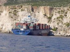
Part of the wreckage of the container ship Napoli has been stripped apart in a dockyard 15 months after it was grounded along the Jurassic coast.
| |  |
Contractors used cutting charges to remove the propeller and rudder and to sever the main drive shaft of the ship, which is stranded off the coast of Branscombe, east Devon. Explosives are also being used to dismantle the vessel so that it can be taken to land by barge and recycled.
The Maritime and Coastguard Agency said that contingency plans were in place to minimise any environmental impact that the operation may have.
Contractors say the operation will take about five months and is the final part of a multi-million-pound salvage project. After the stern is taken from the seabed, underwater surveys of the site will be carried out to ensure that all the debris is removed.
The front section is being cut apart at the Harland and Wolff shipyard in Belfast after being towed there last August. The Napoli started breaking up in bad weather in the Channel in January 2007 and was deliberately beached because it was feared that it would break up and sink. Some of its containers washed ashore and were looted.
MW motorcycles were among items taken before police moved in to close the beach.
| ||
Salvage Law and Practice Seminar
Thursday 19th - Friday 20th June 2008
Lloyd's Maritime Academy Training Suite, London
To download the brochure, click here.
Lloyd’s Maritime Academy is delighted to announce details of the Salvage Law and Practice seminar. This popular and comprehensive two day seminar will provide you with the opportunity to examine some of the most important and complex topics relating to international salvage law and salvage awards.
Whether you are an established player or new to the salvage & wreck removal arena, this seminar is an essential date for your professional diary giving you the opportunity to examine some of the most important and complex topics relating to international salvage law and salvage awards.
The programme has been specifically designed to include case studies and practical sessions, enabling you to gain a first hand understanding of the subject area.
RS














![Validate my RSS feed [Valid RSS]](valid-rss.png)
No comments:
Post a Comment