 Jason-2 arrives in California
 The Jason-2 ocean altimetry satellite has now arrived at its launch site in the United States.
The satellite is currently scheduled to be launched on the morning of 15 June 2008 from Vandenberg Air Force Base in California. Jason-2 was transported by road from the Thales Alenia Space plant in Cannes, France, where it was built, to Toulouse, from where it was flown by a Boeing 747 aircraft to Vandenberg, with a refuelling stop in Boston.
Before its long journey to the West Coast of the United States, the satellite underwent various tests. All environmental testing was completed by the end of 2007 at the Thales Alenia Space plant in Cannes. This was followed by the spacecraft qualification review on 11-13 March, successfully reviewing the testing of the satellite and its instruments, including environmental, thermal, acoustic, mechanical and electrical testing. Operational readiness reviews were held at EUMETSAT at the end of March and between the four partners – EUMETSAT, the French Space Agency (CNES), the US National Aeronautics and Space Administration (NASA), and the US National Oceanic and Atmospheric Administration (NOAA) – at the beginning of April. The pre-ship review authorising the beginning of transfer activities took place on 14 April.
Jason-2’s Ocean Surface Topography Mission will provide a vital contribution to the monitoring of climate change, ocean circulation and weather. Once in orbit and after it has been calibrated by the partners, the satellite will provide oceanographic products on an operational basis to the large EUMETSAT user community using the European weather satellite organisation’s proven dissemination capabilities. The main instrument onboard Jason-2 will be the Poseidon 3 dual frequency altimeter. The final orbit of the satellite will be 1,336 km above the Earth at a 66º inclination.
Ocean altimetry is important for meteorology, with Nowcasting and short range forecasting on one end of the spectrum and monthly and even seasonal forecasting on the other. The assimilation of satellite altimetry measurements (notably the wave height), have considerably reduced the error in two-hourly forecasts. Upper ocean thermal structures are a key factor in the development of storms that can threaten shipping and offshore industries and thus need to be monitored. It is therefore of outmost importance that the mission not only continues but that the resulting data and products are available on an operational basis for all user groups. The mapping and modeling of the upper ocean plays a central role in enabling predictions on the medium-range (10 days), monthly and seasonal timescales. Jason-2 will provide continuity in the monitoring of climate and rising sea levels carried out by Jason-1 and TOPEX/Poseidon over the last 15 years.
Jason-2 is the continuation of the existing successful cooperation between the United States and Europe. It is a global endeavour with responsibilities for satellite development and launch shared between CNES and NASA. CNES and NOAA will be responsible for satellite operations once Jason-2 has reached orbit. NASA's Jet Propulsion Laboratory is managing the mission for NASA. Data processing will be carried out by CNES, EUMETSAT and NOAA, depending on the type of product, with EUMETSAT acting as an interface for near-real-time product distribution to European users.
WEATHER NOTE
Thousands Reported Dead After Burma Cyclone
May 5, 2008
Nearly 4,000 people are dead and nearly 3,000 are missing and dozens are injured after Cyclone Nargis hit the country of Myanmar. The United Nations (UN) states that the death toll could exceed 10,000, in what it calls an “alarming” report.
“The UN will do whatever it can to provide urgent humanitarian assistance. Because of the lack of communications, we are not quite sure what will be the total extent of damages and casualties. I am very much alarmed by incoming views that casualties have risen to more than 10,000, according to Myanmar’s foreign ministry,” said the Secretary-General of the UN, Ban Ki-moon.
The death toll has increased rapidly from Sunday’s count of only 351 deaths.
Food and water has become scarce and hundreds of thousands of people are homeless with several towns being completely destroyed. In the city of Yangon (also known as Rangoon), there is no power and much of the drinking water has been contaminated.
“What is clear is that we are dealing with a major emergency situation, and the priority needs now are shelter and clean drinking water,” said United Nations disaster response spokesman, Richard Horsey.
If the death toll continues to climb, then this would be the single most destructive natural disaster aside from the 2004 Tsunami which killed nearly 200,000 people worldwide.
There are 47.8 million people living in Myanmar with over 5 million in Yangon.
College storm-chasers catch Earle tornado
Saturday, May 3, 2008
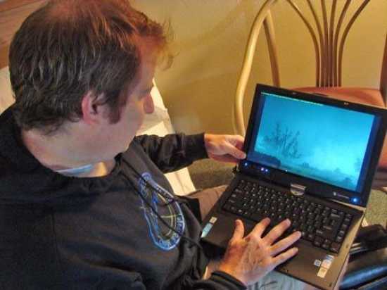
College of DuPage meteorology professor Paul Sirvatka shows video images of the tornado that hit Earle, Ark. on Friday during the chase team's stay in the Best Western Inn in Dyersburg overnight. On Saturday morning the team was returning to eastern Arkansas to survey the damage.
"We were north of it and behind it a little bit, watching the clouds," said College of DuPage meteorology professor Paul Sirvatka, whose team stopped overnight in Dyersburg after chasing storms across the Great Plains for the last week. "Then I said to them, there should be a tornado descend in about 20 seconds. About 20 or 30 seconds later, it did."
Sirvatka called 911 and alerted authorities to the tornado formation. There we no sirens, he said.
Sirvatka said debris was in there air and as the team drove north of the city, the destruction was evident. There were no deaths reported in Earle, but more than 100 homes were destroyed.
Two deputies had crawled from beneath their patrol car that had flipped were standing by the vehicle, said Sirvatka.
"They seemed pretty shaken," he said. "But they said they were alright."
Sirvatka said he was bothered by the number of school buses on the road near the tornado.
"There were busloads of kids literally four minutes away from the tornado," he said. "And we saw that again and again."
The college offers the nation's only undergraduate degree in meteorology. The spring storm-chasing trips are open to independent scientists and weather enthusiasts and students, said Sirvatka.
After following the twister that hit Earle until it dissipated before crossing I-55 about 10 miles north of Marion, Ark., the team crossing the Mississippi River at Dyersburg "and try to get in front of the storm."
The chasers caught swirling formations over the Crockett County area, but saw no more tornados on Friday.
The team overnighted at the Best Western in Dyersburg. They were planning to assess the damage in Earle on Saturday and return to Chicago on Sunday.
Sirvatka said his team had noticed the "Storm Ready" posting at the Dyersburg welcome signs.
"Congratulations for being a Storm Ready community," said Sirvatka. "That means Dyersburg takes dangerous weather seriously. You should."
New online feature brings you behind the scenes
Visitors anywhere in the world can now get a virtual tour of NOAA's National Hurricane Center. With the click of a computer mouse, the online link provides panoramic views of the different rooms in the facility, accompanied by an audio description. You will be able to move around each room in a circle, stop, back up, and zoom in. A text window is available for the hearing-impaired.
Those rooms included in the virtual tour are the National Hurricane Center operations, the Tropical Analysis and Forecast Branch (TAFB) operations, the Chief Aerial Reconnaissance Coordination All Hurricanes (CARCAH), the Federal Emergency Management Agency (FEMA) liaison, Media & Seminar Room, NOAA Miami Regional Library, and the NOAA National Weather Service Miami Forecast Office.
"This is an especially useful tool for students who are learning about tropical cyclones and weather forecasting", said Bill Read, director of NOAA's National Hurricane Center. "It also shows how the different branches of our facility work together for the best possible forecasts."
Click here to begin: http://www.nhc.noaa.gov/nhctour.shtml
MARITIME NOTE
Great Lakes Maritime Events for May
May 10 - Toronto Marine Historical Society Annual Dinner meeting
After a social time and meal at Capt. John's Restaurant aboard Jadran, enjoy an illustrated presentation on the C.P.R. passenger steamer Keewatin which celebrated her 100th anniversary in 2007.
May 17 & 18 - Door County WI Annual Lighthouse Walk May 23-25 - 40 Mile Point Lighthouse 9th Annual Memorial Day Weekend Open House
Annual tour involves five lighthouse sites from Sturgeon Bay north to Fish Creek, Wisc. Separate boat tours take passengers to or past five lighthouses on outlying islands. Sturgeon Bay, WI. www.dcmm.org
Sponsored by the 40 Mile Point Lighthouse Society. All buildings open to the public. Includes the 4th Annual Afternoon of Arts & Crafts Show on May 24 and 25, 2008. Free admission and complimentary light refreshments. Located north of Rogers City, MI.
May 25 � Lake St. Clair & River Cruise & BoatNerd Gathering
An all day cruise leaving Hart Plaza in downtown Detroit and traveling up to the Blue Water Bridges. Co-sponsored by the Marine Historical Society of Detroit and BoatNerd.com, the trip includes a continental breakfast and deli lunch on board, and a buffet dinner at the historic St. Clair Inn. Tickets are $90.00 per person and reservations are required. Click here for details and a reservation form.
A Collage of Ship Accidents
RS


![[Valid RSS]](valid-rss.png "Validate my RSS feed")
No comments:
Post a Comment