 "Freak" Hurricane Ike Will Cost $22 Billion
Hurricane Ike will be entered into the record books for the severe damage it inflicted in and around Galveston, Texas, experts say.
"This one's going to be famous for a long time, if for no other reason than it hit Texas, which hadn't gotten a strike by a damaging hurricane in 25 years," said Jeff Masters, director of Weather Underground, a private commercial forecasting service.
Masters also noted that the cost of Ike's rampage along the Gulf Coast could reach U.S. $22 billion, which would make it the third costliest hurricane on record behind Hurricane Katrina in 2005 and Hurricane Andrew in 1992.
The center of Hurricane Ike made landfall around 3 a.m. EDT Saturday at Galveston. The storm's peak winds were clocked at 110 miles (177 kilometers) an hour, making it just short of a major Category 3 hurricane. (See photos of the hurricane's aftermath.)
But the storm's enormous size—nearly as large as the state of Texas—spread its destruction from eastern Louisiana to Texas.
"Freak" Storm
The worst of Ike's damage was caused by its huge storm surge, a mound of water pushed ashore by the storm's winds. (Watch video of Ike's waves crash over buildings in Cuba.)
Because of Hurricane Ike's huge size, its storm surge of 10 to 15 feet (3 to 4.6 meters) above normal tides was much bigger than a Category 2 hurricane usually would create.
When Hurricane Ike struck eastern Cuba last week, it was a very powerful Category 4 hurricane with peak winds of about 145 miles (233 kilometers) an hour.
But the storm's long trip across Cuba caused the hurricane to weaken and spread out.
Ike stayed large when it moved off the western tip of Cuba and into the Gulf of Mexico, said James Franklin, a forecaster at the National Hurricane Center in Miami.
"One of the issues with Ike was how long it took for the core of the hurricane to recover from its passage over Cuba, Franklin said. "At one time, it was forecast to be a Category 4 hurricane at landfall [in the U.S.].
"I think we were anticipating that it might have intensified a little faster over the Gulf. But very often, you see storms that never recover after they have had interaction with land."
Masters said Ike became a "freak" over the Gulf of Mexico because its barometric pressure started dropping, which is usually an indication that a hurricanes winds are strengthening. Ike's winds did strengthen some, but not as much as forecasters expected.
Still, Ike was so large that its winds set most of the Gulf of Mexico into motion, and that's why its storm surge became so large and destructive.
Killer Storm
The hurricane has killed at least 34 people in the U.S.
Rescue workers are still trying to reach some coastal residents who did not heed the National Weather Service's dire warning to evacuate in advance of the storm.
Among the residents who did not leave were about 500 people on the Bolivar Peninsula just north of Galveston.
When Ike made landfall, the peninsula was hit by the storm's front-right quadrant, which carries a hurricane's peak winds and maximum storm surge.
Masters noted that 80 percent of the homes on Bolivar Peninsula were destroyed.
Dan Reilly, a meteorologist at the Houston-Galveston National Weather Service office, said Ike's storm surge combined with large pounding waves caused the damage on the peninsula.
The arrival of a storm surge is gradual as the hurricane approaches land and pushes the edges of the surge ahead of its center. But the surge steadily increases as the center of the hurricane gets closer.
When the hurricane's eye arrives, the powerful winds can create large breaking waves riding atop the surge, and these waves are very destructive as they crash down on buildings.
Reilly said the surge and pounding waves caused heavy damage on Bolivar Peninsula and the southwestern end of Galveston Island. But the surge did not top the city's 17-foot (5.2-meter) seawall, built after a devastating hurricane in 1900. (See scenes of the devastation left behind after the 1900 hurricane.)
Masters added that although the 2008 Atlantic hurricane season still has more than two months remaining, the rampage of Hurricane Ike and earlier storms that formed in the same area this summer may prevent future storms in the Gulf of Mexico and the Straits of Florida from becoming as powerful as they might otherwise have been.
"They all acted to cool down the ocean in the Gulf and around the Bahamas," Masters said. "So the next storm that comes through will not have as much heat."
WEATHER NOTE
Lessons from disasters like Ike
America has tightened building codes in danger zones, but it also needs to stop building.
from the September 19, 2008 edition
Nearly a week after Galveston Island took a severe beating from hurricane Ike, a Kroger grocery store has finally opened for business, grilling up fajitas for its employees. With the Texas island still not ready to take back evacuees, the open store is at least one encouraging sign of normalcy.
For that is the aim of rescue and relief workers, government officials, neighbors, and perfect strangers who all assist in the aftermath of any disaster – to help residents return to as normal a life as possible.
But normalcy has its downside in America's hazard-prone areas. If it means rebuilding exactly as everything was before the hurricane, fire, or earthquake, then business-as-usual is itself hazardous.
The country has learned to do some key things differently in the wake of several years of weather whammies. One of them is to adopt stricter building codes that save lives and money.
New building and landscaping standards spared five communities from San Diego's fierce fires last year. In 1992, when the worst mainland hurricane in US history slammed into Florida, 27 Miami-area houses built to hurricane-resistant standards suffered no structural damage, while other homes nearby were flattened.
Florida now has the most stringent hurricane building codes in the country. After Katrina and Rita in 2005, Gulf states caught on, with Louisiana, for instance, passing a statewide code. Structures along the Mississippi coast are being rebuilt on stilts.
Good job, except for this huge oversight. The rebuilding, with few exceptions, is taking place in the same spots that were wiped out. As naturally as snow falls, people want to build in warm places with beautiful beach vistas – no matter that they're on a vulnerable barrier island such as Galveston.
One thing that would discourage the pounding of pylons in obvious danger zones is market-priced property insurance. It's telling that private insurers have for the most part pulled out of the Gulf coastal areas. As of Nov. 30, State Farm won't renew even existing policies for customers within 1,000 feet of the shoreline.
Customers have therefore swarmed to subsidized state insurance programs, and, of course, should these fail, there is always the National Flood Insurance Program. Or not. Congress is wrangling over renewal of the program, which expires Sept. 30. Sadly, both House and Senate bills perpetuate low-cost insurance that only encourages more building in dangerous zones.
In the absence of correcting market forces, populations along the coastal counties of the Atlantic and Gulf coasts have popped up like beach umbrellas. In 1980, about 67 million people lived in these counties, according to the US Census Bureau. In 2006, just over 88 million. And little has discouraged developers – at least before the housing bust – from marching up the tinder-dry hills of California.
State and local governments should either wean themselves from taxpayer-subsidized, low-cost insurance – or block off the most vulnerable areas. It is possible. After the 1977 Red River flood, Grand Forks, in North Dakota, marked off a "no build" zone near the river. Two decades ago, South Carolina began a gradual retreat from the sea – redrawing its baseline at the shore every 10 years.
Now in Texas, the land commissioner, Jerry Patterson, is proposing that new coastal construction be set back at 60 times the erosion rate – for example, 60 feet for every foot of erosion. Before Ike, he was blasted by local officials who said the restrictions would erode development and resulting tax revenue.
With so much washed out to sea or piled up as debris, Galveston – and other communities – should be welcoming Mr. Patterson's proposal. To prepare for disasters, America should not just batten down, but step back.
IAFC Recommends Hurricane Responses
The International Association of Fire Chiefs has produced a list of model procedures for responding to hurricanes and tropical storms. The guidelines can help chief officers establish a policy for response that minimizes the risk to fire/EMS personnel and protects the department’s human, physical and cyber-infrastructure critical to safeguard a community before, during and after a storm.
Some of the guidelines for creating a safe environment for personnel are:
- Review the fire department’s standard operating guide, update as needed and review with all members. Obtain and review the most recent version of the fire department’s continuity of operations plan.
- Update target occupancies list. A target occupancy might be an occupancy with a high probability of trapped victims or a structure that stores a large amount of hazardous materials or is susceptible to structural failure, such as schools, hospitals, health-care facilities and factories.
- All companies familiarize themselves with the topography of their response area to become aware of flood-prone areas.
- Inventory all equipment.
- Ensure apparatus readiness.
- Check the physical condition of each department building and facilitate repairs of any damaged roof areas, windows or doors that could contribute to increased damage in a hurricane. Check and service as needed any sump pumps for basement areas. Be sure all surface-area drains around the exterior of buildings are free and clear of all debris to allow for proper drainage.
- Ensure all fire department generators have been serviced and are working.
- Inventory and check batteries and chargers for portable equipment and be sure all are in working order and that there is an adequate number available.
- Maintain all apparatus fuel tanks at no less than three-quarters full.
The full report, are available at www.iafc.org.
By David Wilcock
All work on salvaging the remaining part of the MSC Napoli will be halted until next year because of bad weather, it was announced yesterday.
All that remains of the vessel, which was grounded off East Devon, is the rusting stern section, which was expected to be removed by the end of October, marking the conclusion of an estimated pounds50 million salvage operation.
However, the Secretary of State's representative for maritime salvage and intervention, Hugh Shaw, has agreed with environmental groups, the salvors and insurers representing boat owner Metvale that autumnal storms make the work too dangerous to continue.
It means the wreck could still be off Branscombe beach two years after it was grounded there in January 2007.
Mr Shaw said: "The decision to suspend salvage operations for the MSC Napoli was necessary to lessen the risks that the onset of harsher autumnal weather would have presented to the safety of the salvors involved and the local environment.
"The conditions under which salvors are operating are now becoming increasingly treacherous. During the initial incident, no lives were no lost and my aim is to lessen the risks to anyone involved in the operation during this final phase."
He said 2,800 tonnes of the aft section of the 60,000 tonne vessel have been removed. But the remaining section is heavily constructed and "proving difficult to dismantle", especially the 1,400 tonne engine.
"The vessel's location and exposure to the elements has not helped salvage activities," he said. "There is also an estimated 3,000 tonnes of silt and clay trapped inside the ship and adding substantial weight to the overall structure.
"My goal continues to be the removal of as much of the remaining aft section, as is practicably possible, balanced against the environmental sensitivities of the Lyme Bay area."
The news was met with dismay by some villagers in Branscombe.
Guy Bentley, who runs the Old Baker Tea Shop, said the continued presence of the wreck and the workers was affecting village life. "As a general rule for the locals, we cannot wait for everything to get back to normal again," he said.
"It will be nice to see the back of it. I live down by the beach and I go out there every night and you cannot see the night sky for the lights from the workers' camp.
"It ruins the whole beachfront and I'm sure it destroys the character for regular visitors."
A 500m temporary exclusion zone remains in place around what remains of the wreck off Branscombe beach.
Additional navigational marks will be deployed around the wreck, while counter-pollution response measures including personnel and equipment will remain in place.
The Maritime and Coastguard Agency will continue its regular flights over the site.
Another villager, Anthony Sellick, said it might not be a bad thing for the recovery and teams to stay for another winter.
"The wreck isn't doing any harm and the teams patrolling the beach are doing a good job of recovering things," he said.
"There is going to be a certain amount of stuff on the sea bed which will wash up over the winter.
"Bits of steel and other material are still washing up on the shore which isn't good. But we are not suffering as much as we first feared."
Coast Guard Crew Sickened Surveying Damage
HOUSTON -- A U.S. Coast Guard crew that stumbled upon a group of washed-away chemical tanks on Sunday evening was taken to the hospital, KPRC Local 2 reported.
Coast Guard Lt. Steve Morris said the crew maneuvered their boat next to the chemical tanks that had washed up under the hull of several barges, and they began feeling sick when they returned to shore.The crew of six went to the hospital complaining of watering eyes, scratchy throats and dizziness.The Coast Guard dispatched its Maritime Safety Security Team from Boston and other cities to comb through the Houston Ship Channel to look for damage and inspect for dangers. Along with the floating tanks, they encountered large equipment floating in the water after having broken away from various petrochemical plants and refineries. Coast Guard crews bumped their boats up against some of the large debris to push it into areas where it can remain until cleanup can be organized.
Other damage along the channel spotted by the Coast Guard teams included several barges and at least one oil tanker that had run aground after breaking free from docks, large oil tanks pushed and bent at the Magellan facility dock, overturned trucks and other equipment onshore, and one large door caved in on a warehouse structure. The Coast Guard reported it has not found any widespread oil slick or other spill similar to what it saw with Hurricane Katrina.Only tugboats were cleared for travel through the Ship Channel, and no decision had been made on Sunday night as to when tankers and freighters would resume.
To the end of the world, in Magellan's wake
Though safer and more luxurious, voyages still face uncertain weather and treacherous waters
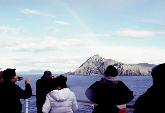 |
TIERRA DEL FUEGO, Chile - At 7:45 a.m. on a Sunday in early January, several hundred passengers aboard the
As if on cue, bitter-cold wind hurled tiny daggers of ice crystals at the mariners, sending many of the less-stalwart scuttling for the nearest doorway. Others weathered the onslaught and hoped for the best.
Suddenly, the roiling skies cleared, and a rainbow appeared, glancing off the craggy granite rock face of Cape Horn.
"This is what we came all this way to see," exclaimed passenger Bobbi Sorensen of Atlanta. "It was a real thrill!"
Her husband, Tom, a seasoned sailboat captain, marveled at the blackness of the granite rocks and the isolation of the continent's southernmost outcropping. "Cape Horn is literally the punctuation mark at the end of the world," he said.
Author and on-board historian James W. Reid proclaimed this particular rounding of the Cape the best he'd seen in 100 voyages. "Travel is very uncertain in this part of the world, and the unpredictable weather makes you stop and think: How did [Ferdinand] Magellan . . . do it?" he said.
Reid presented slide shows and lectures on South American history, ports of call, and points of interest throughout our 14-day cruise to Valparaíso.
"Here, the magic of the past has not faded with time," he said. "You can still relive the days of these early navigators and see the same things they saw as you sail around the Horn and through the Strait of Magellan and the Beagle Channel ."
Today, cruising around the tip of South America is much safer, more luxurious, and far more affordable than ever. Celebrity, Princess, Norwegian Cruise Lines, Silversea, and other cruise companies offer a variety of sailings, with multiple ports of call in Argentina, Chile, and Uruguay. Some itineraries also include Rio de Janeiro during Carnival, the Falkland Islands, or Antarctica. The best time to cruise is during our winter months when it is summer in the Southern Hemisphere. But be forewarned: High winds and cold temperatures in Patagonia and Tierra del Fuego can make for wintry conditions, even in summer.
Like many Cape Horn passengers, Mary and Dennis Murphy of Groton were eager to chart a new course. "We haven't been to South America and wanted to get a general feeling for the area, so we can decide whether to return and explore it in greater depth," said Mary. "We also were attracted to this cruise itinerary by the prospect of seeing beautiful natural features and unusual animals, such as penguins and sea elephants."
Although the couple had sailed on smaller ships, this was their first cruise aboard a 2,500-passenger liner. "It's a great value for the money," Mary said. "There are tons of choices in excursions and activities - something for everybody. The ship also has great food and amenities. If you are interested in rounding Cape Horn, you couldn't do it on a smaller vessel for the same price."
Passengers traveled from 38 countries to sail aboard the Infinity, creating what Allan King , the cruise director and a native of Scotland, likes to call a "floating United Nations." Evening entertainment featuring Argentinian gauchos and Latino singers, afternoon tango lessons and optional rodizio dinners (where meat is grilled on skewers) added a south-of-the-equator flair.
"Anybody approaching South America has to look with open eyes and expect the unexpected," King said. To get the most from the voyage, he recommended passengers research the ports of call and book excursions well in advance. "This is a different type of cruise vacation than you will experience in the Caribbean or Alaska," King explained. "In South America, the port cities are gateways to places of interest."
On the morning the Infinity arrived in Montevideo, Uruguay, our first port of call after leaving Buenos Aires the day before, thick sides of beef, pork, and lamb were sizzling on wood-fire grills at small bistros inside the cavernous Mercado del Puerto near the port terminal. A pleasant walk through the Old City took us past timeworn Parisian-style buildings, open-air fruit markets, and vendors' stalls to the immense Plaza Independencia. In the center of the square, a regal bronze statue of General José Gervasio Artigas on horseback honors the "father" of Uruguay.
That afternoon, we traveled 45 minutes by bus north from Montevideo to the Juanico Winery in Uruguay's principal wine-producing region for a leisurely drive through the estate's 600 acres of lush vineyards and a tour of their oak-barrel aging cellar. Inside the wood-beamed tasting room we sampled six wines, including a 2002 Preludio Barrel Select, an elegant blended red. Many passengers in our tour group purchased bottles to take back to the ship.
A sea lion bobbing in choppy waters was the first to greet the Infinity at Puerto Madryn, a rather drab Argentinean town founded in 1865 by Welsh settlers. Despite its lackluster appearance, the area is a jumping-off point for rich nature areas. To the east, the Valdes Peninsula, one of South America's finest wildlife reserves, is home to immense southern sea elephants, sea lions, seals, and flocks of sea birds. One hundred miles to the south, the Punta Tombo Penguin Rookery hosts the largest penguin nesting ground on the continent and is the best place to rub elbows with an estimated 2 million Magellan penguins.
"Part of the attraction of South America for nature lovers is the opportunity to sail the southern oceans and encounter distinct populations of sea creatures, birds, and land-dwelling animals that you don't see in the Northern Hemisphere," explained Milos Radakovich, our on-board naturalist.
Our often bumpy, dusty three-hour ride to Punta Tombo took us through arid scrub land, reminiscent of Baja California. Sparse herds of fuzzy brown guanacos, or wild llamas, munched dry grass far from the roadside.
At the rookery, a pebble pathway led through pocked rolling hills, where fluffy gray penguin chicks snoozed in shallow burrows or peeped incessantly for their parents. The handsome black-and-white adult birds paraded single-file across the path. From a lofty viewing area atop a precipice on the seacoast, we gazed down at thousands of penguins, bobbing in the chilly waters for fish and sprawling on the sandy shore.
"We saw the march of the little, or fairy, penguins in Australia," said Judith Goldstein of South Windsor, Conn. "We loved it and selected this tour because it enabled us to view penguins in their natural habitat."
The fierce winds of Patagonia kicked up a blinding dust storm when we returned to the Infinity, delaying boarding for two hours. At times the thick dust nearly obliterated the shoreline and another cruise ship nearby. This blustery send-off from Puerto Madryn proved to be the initial salvo of a major gale that packed sustained winds of 60 miles per hour with gusts up to 90 miles per hour, and sent 30 foot waves crashing against the ship's hull. For the next two days, sailing was rough.
The Infinity's public-address system chimed early on the morning we were scheduled to drop anchor off Stanley, the capital of the Falkland Islands. Captain Athanasios G. Peppas, a veteran of 10 Cape Horn voyages, explained that heavy seas would prevent the ship's tenders from transporting passengers to shore and, therefore, the visit to the Falklands was canceled.
Later that day Peppas told us it is not uncommon for foul weather to scuttle disembarkation plans in the Falklands. "This is not just a cruise; it's an adventure," he said.
Fortunately, the seas calmed as we neared Tierra del Fuego ("land of fire"), assuring us our memorable rounding of Cape Horn, which was named after the Dutch town of Hoorn, the birthplace of navigator Willem Schouten. In 1615, the prominent Dutch merchant Isaac Le Maire raised money and hired Schouten to lead an exploratory voyage in search of an alternate route from the Atlantic to the Pacific, south of the Strait of Magellan, which was charted a century earlier. Schouten succeeded in finding that southerly route, known as the Strait of Le Maire, in 1616.
After leaving Cape Horn, the Infinity sailed up the Beagle Channel to Ushuaia, Argentina, which calls itself the southernmost city in the world. Nestled along a small, boat-studded harbor, this frontier town exudes a slightly Bavarian flavor, with its peaked clock tower and Alpine-style buildings. On San Martin Street, we shopped for jewelry, sheep's wool throws, and leather jackets while checking the menu offerings of local restaurants for king crab and grilled steaks. Our afternoon excursion took us through dramatic vistas in Tierra del Fuego National Park aboard the rather touristy and pricey "train at the end of the world."
The remaining days of our cruise included stops at two Chilean ports of call. Punta Arenas, the oldest and largest city in Chilean Patagonia, offered a spectacular view from atop Hill of the Cross Lookout and an opportunity to walk through the lavish mansion, now a cultural center, built by Patagonian pioneer Mauricio Braun in 1905. Puerto Montt, originally a German settlement and now the gateway to the southern lake area, featured the area's largest artisan market, with a tremendous selection of handcrafted clothing, jewelry, and leather goods, just a few minutes walk from the passenger terminal.
The highlights were our evening sail past the five ice-blue glaciers glittering like crown jewels along the Beagle Channel west of Ushuaia and the full day we spent wending our way through the Chilean fiords. At times snow-etched peaks loomed above the Infinity, casting long shadows on passengers sunbathing below on the ship's top deck.
Before disembarking in Valparaíso, each passenger received a certificate commemorating the voyage. For Harvey and Harriet Ellis of Warminster, Pa., completing the nearly 4,000-mile cruise was a triumph.
"We're living in a time when middle-class people can travel to exotic places that were impossible to reach, except for the very well-to-do, even a century ago," Harriet said. "Cape Horn is literally the world's last outpost, and we decided that if Magellan could do it, so could we."
Salvors to produce Casualty Management Guidelines

The AHTS 'Boulder' responded earlier this year when the general cargo vessel 'B Prus' had engine problems in severe weather some 160 miles west of La Corunna.
The guidelines will assist governments, shipowners and managers, port authorities and other interests directly involved in ship salvage operations.
Commenting on the initiative, President of the ISU Arnold Witte said, 'There is existing International Maritime Organization (IMO) guidance on the issue of places of refuge. There is also very general IMO guidance on general issues relating to the control of ships in emergency situations. What is missing is specific, comprehensive guidance on best practice throughout the entire casualty management process. The MCM Guidelines will fill that gap and, in doing so, will sharpen and enhance marine emergency response capabilities worldwide. Our intention is to consult with our maritime industry partners when finalising the guidelines.'
Read the full story in the October issue of Maritime Journal.
Injury on ship transiting to OCS facility controlled by general maritime law
The US Court of Appeals for the Fifth Circuit ruled that an action for personal injury brought by an offshore platform worker injured while being transported by a vessel on the high seas is controlled by general maritime law, rather than the Outer Continental Shelf Lands Act (OCSLA). The dispute in the instant case was between the worker’s employer and the owner of the vessel on which he was injured. The employer and the owner had entered into an indemnity agreement regarding such claims. Such indemnity agreements are disfavored under the OCSLA, but are generally permissible under general maritime law. Grand Isle Shipyard v. Seacor Marine, No. 07-31019 (5th Cir., September 22, 2008).
UK – report on deaths by asphyxiation
The UK Marine Accident Investigation Branch (MAIB) issued the report of its investigation of the death by asphyxiation of two crewmembers on board a bulk carrier approaching Dover Strait on 18 January 2008. A cargo of steel turnings had been loaded, without clear notice of the specific nature of the cargo as dangerous and subject to self-heating. At some time in the past, a direct air path had been inadvertently created between the cargo hold and the forward store. When the two crewmembers entered the cargo store, they succumbed to the lack of oxygen. It has been recommended that improvements be made with regard to cargo notifications and enclosed space management. Report No. 15/2008 (9/23/08).
The National Oceanic and Atmospheric Administration (NOAA) issued a news release stating that the Interagency Report on Marine Debris has been completed. The report was prepared at the request of Congress and focuses on marine debris sources, impacts, and strategies. Among other things, it notes that approximately 49% of marine debris originates from land-based sources, approximately 18% originates from ocean-based sources (ships, offshore structures, etc.), and approximately 33% was classified as general source debris because it could have come from land- or ocean-based sources. The Environmental Protection Agency (EPA) issued similar news release. (9/22/08).
'Princess' hull cut open on Day 2 of salvage operations
Divers from Titan Salvage and Harbor Star have successfully cut a small hole through the hull of the capsized M/V Princess of the Stars on Thursday, the second day of retrieval operations for the chemical cargo inside the ship.
The Task Force Princess of the Stars, in a statement, said the salvors first surveyed the capsized ferry to determine where the toxic cargo is located - first by using a ROVO, remote operated videocamera, which surveyed the inside of the ship, and then via the divers. The divers were then able to cut an opening close to the target container.
"On our 2nd full working day, we managed to cut a 1 meter by 1.5 meters opening at the starboard (right) side of the ship, 1 meter away from the container of the endosulfan. If the good weather holds till tomorrow (Friday), we will be able to make the opening 2 x 2.5 meters, allowing divers to go in," Capt. Roberto Aris of Harbor Star was quoted as saying.
The Philippine Coast Guard also said marine life under the ship was also reported as normal by the divers, citing the presence of numerous fish in the area.
The salvors are speeding up their retrieval operations for fear that an oncoming typhoon might affect the weather in the area and hamper their operations anew.
The retrieval operations for the chemical cargo entombed inside the capsized M/V Princess of the Stars commenced Wednesday, after almost a week of delays due to bad weather.
Titan Salvage, the salvaging company contracted by the ship's owner Sulpicio Lines, and its local counterpart Harbor Star on Wednesday started surveying the capsized ferry, located off the coast of San Fernando, Romblon.
The survey is part of retrieval operations for the chemical cargo inside the ship, which include the pesticide endosulfan and several other containers of dangerous chemicals.
The survey was done to study where the divers and their equipment would best pass through to get to the ship's cargo hold, where the chemicals are located.
Titan and Harbor Star said they will work faster to be on schedule after almost a week of delays due to rough seas.
On Tuesday, retrieval operations were delayed due to heavy downpour that also caused the collapse of two bridges connecting the town of San Fernando to the site of the shipwreck.
The only activity performed Tuesday was to check the moors connecting the "Big Time" barge, the salvaging firms' working platform beside the capsized ship, to see if these were still intact and the anchors secure.
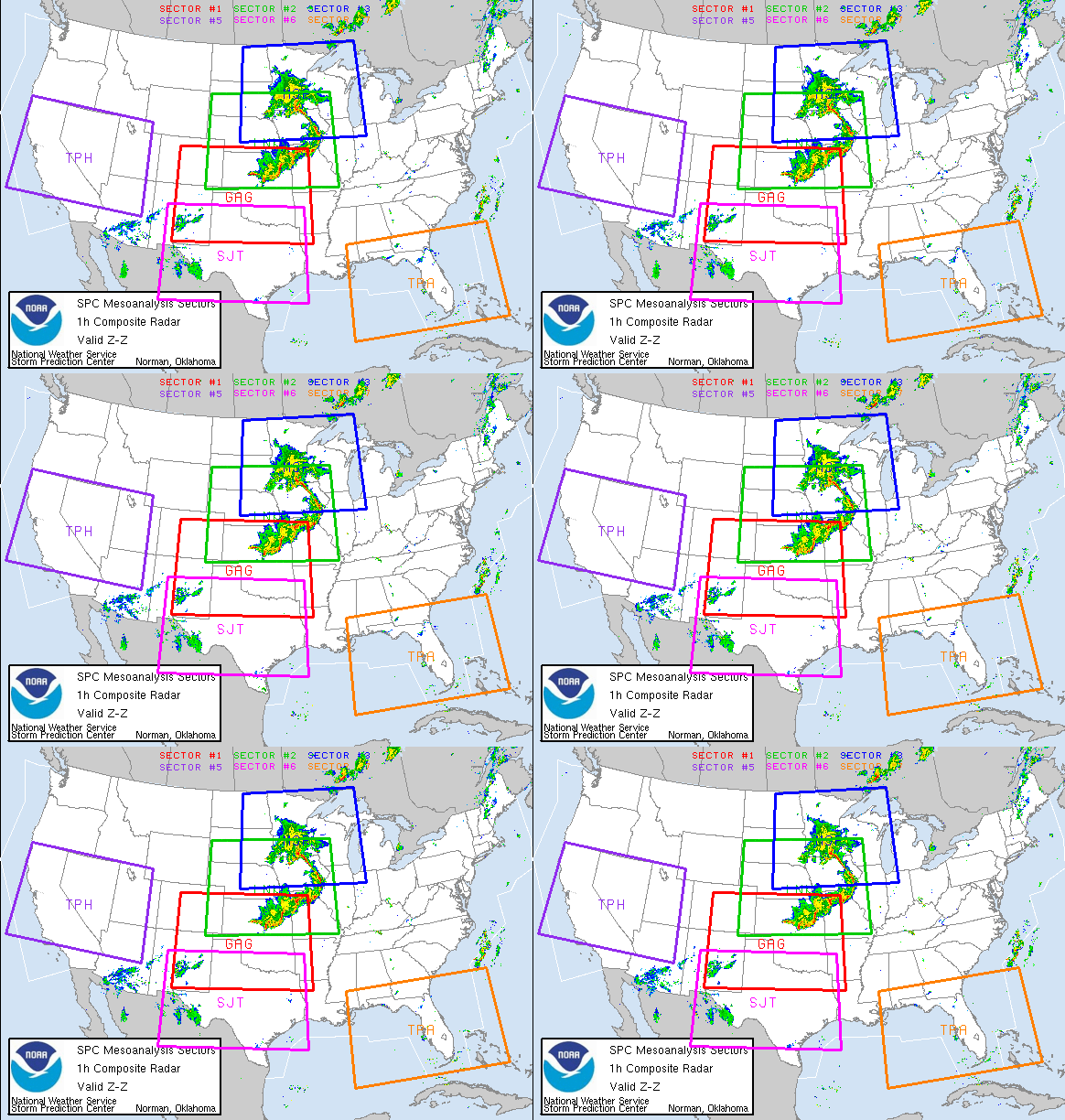
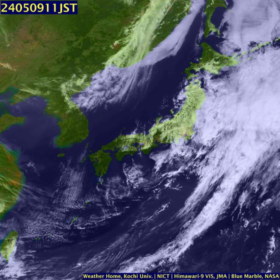
NEW RIVER AND HURRICANE IKE
Tanker 150 nm NE of Hurricane IKE on Sept 11, 2008.
STAY SAFE
RS










![Validate my RSS feed [Valid RSS]](valid-rss.png)
1 comment:
When the hurricane's eye arrives, the powerful winds can create large breaking waves riding atop the surge, and these waves are very destructive as they crash down on buildings.
Post a Comment