 Tropical Cyclone Report Tropical
Storm Ingrid (AL082007) 12 – 17 September 2007
Michelle Mainelli
National Hurricane Center 17 October 2007
Ingrid was a tropical storm that formed over the central tropical Atlantic Ocean and dissipated as it approached the Leeward Islands.
Synoptic History
Ingrid developed from a large tropical wave that exited the coast of Africa on 6 September. At that time, strong easterly shear inhibited development over the eastern Atlantic and it was not until 9 September that a broad area of low pressure developed along the wave axis, about midway between Africa and the Lesser Antilles. The easterly shear gradually diminished over the next several days, which allowed the system to maintain convection near the low center on 11 September, when Dvorak classifications were initiated. By the morning of 12 September, the system acquired sufficient organization to be designated a tropical depression, while centered about 980 n mi east of the Lesser Antilles.
The “best track” chart of the tropical cyclone’s path is given in Fig. 1, with the wind and pressure histories shown in Figs. 2 and 3, respectively. The best track positions and intensities are listed in Table 1. The depression moved on a general west-northwestward track within a weak steering flow south of a mid-tropospheric ridge. Despite moderate westerly shear, the cyclone became a tropical storm around 0600 UTC 13 September, while centered about 730 n mi east of the Lesser Antilles, and reached its maximum intensity of 40 kts 12 h later. Persistent westerly shear, due to a stronger than normal upper-trophospheric mid-oceanic trough located west-northwest of the cyclone, prevented further intensification. During the next 24 hours, the shear increased, which resulted in Ingrid weakening to a tropical depression by 1800 UTC 15 September. Ingrid remained a tropical depression for a day or so before degenerating into a remnant low around 0600 UTC 17 September, while centered about 140 n mi east-northeast of Antigua. The remnants of Ingrid moved slowly northwestward and west-northwestward within the lower-tropospheric steering flow, and the low dissipated on 18 September.
Meteorological Statistics
Observations in Ingrid (Figs. 2 and 3) include satellite-based Dvorak technique intensity estimates from the Tropical Analysis and Forecast Branch (TAFB) and the Satellite Analysis Branch (SAB), as well as flight-level and Stepped Frequency Microwave Radiometer (SFMR) surface observations from several flights of the NOAA P-3 research aircraft. Microwave satellite imagery from NOAA polar-orbiting satellites, the NASA Tropical Rainfall Measuring Mission (TRMM), the NASA Aqua, the NASA QuikSCAT, the Department of Defense WindSat, and Defense Meteorological Satellite Program (DMSP) satellites were also useful in tracking Ingrid.
The estimated peak intensity of Ingrid on 14 September represents a blend of the surface-adjusted flight-level winds and SFMR data from the NOAA P-3 aircraft. During the morning flight on 14 September, the SFMR reported a maximum 51 knot wind over the southwestern quadrant of the storm; however, this observation did not appear representative of the strength of the poorly-defined circulation. The minimum pressure of 1002 mb is based on a dropsonde pressure of 1004 mb that was accompanied by a 26-kt surface wind, which indicates that the dropsonde probably did not sample the center of the cyclone and its lowest pressure.
No ship or land station reported sustained winds of at least tropical storm force in association with Ingrid.
Casualty and Damage Statistics
There were no reports of damage or casualties associated with Ingrid.
Forecast and Warning Critique
The genesis of Ingrid was well anticipated. The tropical wave that eventually spawned Ingrid was first introduced into the Tropical Weather Outlook (TWO) at 0230 UTC 7 September, about five days prior to genesis. At that time, the wave was located a few hundred miles south of the Cape Verde Islands. For the next couple of days, there was continual mention in the TWO that slow development of the system was possible. By late on 9 September, the potential for tropical depression formation was explicitly mentioned in the outlook. It was not until early on 12 September that the system acquired enough organization to be designated as a tropical depression. This resulted in a 54-hour lead time between the first mention of potential tropical depression formation in the TWO and when tropical cyclogenesis actually occurred.
A verification of NHC official and guidance model track forecasts is given in Table 2. Average official track errors for Ingrid were 28, 52, 89, 115, 145, and 154 n mi for the 12, 24, 36, 48, 72, and 96 h forecasts, respectively. These errors are lower than or close to the average long-term official track errors for all forecast periods (Table 2). Both the GFSI and UKMI models performed relatively well in comparison to the other dynamical model guidance. Notably, the UKMI had lower track errors than the official forecasts at all forecast lead times except for 24 h. Both the GFSI and UKMI kept a more westerly track compared to the other dynamical models during the first couple of days. The GFSI and UKMI maintained Ingrid as a weak system and anticipated the ridge to the north of the cyclone to remain intact. On the other hand, the NGPI had the largest errors as it forecasted a stronger Ingrid to take a more northwestward track in response to a weakness in the subtropical ridge. Despite somewhat of a dichotomy in the model guidance, the official track forecasts correctly maintained Ingrid on a more westward track within the low- to mid-level steering flow.
Average NHC official intensity errors were 2, 4, 4, 8, 18, and 28 kt for the 12, 24, 36, 48, 72, and 96 h forecasts, respectively (Table 3). For comparison, the average long-term official intensity errors are 6, 10, 12, 14, 18, and 20 kt, respectively. The official intensity forecast errors were slightly below the average long-term errors through 72 hours; however, they were larger than the average error at 96 h. Even though only three official forecasts verified at 96 h, the larger than average errors at that forecast time can be attributed to the global models predicting that the shear would lessen, which would allow for gradual strengthening of the cyclone. The GHMI provided the most accurate intensity guidance and did particularly well in the later forecast periods. It is notable that the GFDL Hurricane Model correctly predicted the weakening, in this case, in the sheared environment. In earlier years that model was notorious for over-intensifying tropical cyclones in environments of strong vertical shear. This change could be attributable to recent improvements in the GFDL model physics.
Read the rest of the report here: Tropical Storm Ingrid – PDF – MSWord
More on the October 18, 2007 Heartland Storms -
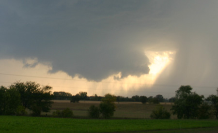
October 18, 2007 Greenville to Neoga, IL Chase
by John Farley
The setup:
An unusually strong - below 29.00 inches surface low over Minnesota - storm system was moving through the Midwest. The system was negatively tilted, with extremely strong mid and upper level winds from the southwest over surface winds that would range from SSW in western IL to southerly in eastern IL ahead of a cold front/dryline that would push across Illinois late in the day. At first it looked like the system would move through too fast for daytime storms in IL, but by the night before, it began to look like the timing would be better. Read the rest October 18, 2007 Greenville to Neoga, IL Chase
RS


 What is the single most import piece of electronics aboard your ship? For me it's the EPIRB. If all else fails the EPIRB should get my position to the
 Why did he release this issue early? ….because it's a look at lifeboat safety and more specifically the details of a recent incident that claimed the life of three maritime officers, a bosun and cadet.


 Subscribe
![[full basin map of tropical cyclone activity]](http://www.nhc.noaa.gov/tafb_latest/refresh/danger_atl_latestBW_sm2+gif/085524123_sm.gif)























































![[Valid RSS]](valid-rss.png "Validate my RSS feed")