Friday, August 24, 2007

NOAA INCREASES U.S. TSUNAMI WARNING CAPABILITY

NOAA INCREASES U.S. TSUNAMI WARNING CAPABILITY WITH FOUR DART BUOY DEPLOYMENTS

NOAA image of one of NOAA's newly deployed Deep-ocean Assessment and Reporting of Tsunami, or DART stations. Please credit "NOAA.August 3, 2007 — NOAA’s National Data Buoy Center has successfully established four new tsunami stations in the northwest Pacific Ocean, east of Japan and Russia. The four Deep-ocean Assessment and Reporting of Tsunami, or DART stations, help provide additional detection and warning capability for Hawaii, Alaska and the West Coast of the United States. (Click NOAA image for a larger view of one of NOAA's newly deployed Deep-ocean Assessment and Reporting of Tsunami, or DART stations. Click here for high resolution version. Please credit "NOAA.")

“The DART network is part of an ongoing effort to increase the U.S. tsunami warning capability," said retired Navy Vice Adm. Conrad C. Lautenbacher, Ph.D., under secretary of commerce for oceans and atmosphere and NOAA administrator. "Our detection capabilities also feed into the Global Earth Observation System of Systems, which means our data are part of a shared network that benefits the global community."

This deployment brings the total number in the U.S. DART network to 32 stations in the Pacific and Atlantic oceans, the Caribbean Sea and the Gulf of Mexico. When the network is completed in March 2008, NOAA will operate a total of 39 U.S. DART stations.

NOAA image of DART locations as of August 2007. Please credit "NOAA."As waves travel across open waters, the DART stations provide real-time tsunami detection to forecasters at the NOAA tsunami warning centers. Each DART station consists of a bottom pressure sensor anchored to the seafloor, and a companion moored surface buoy. An acoustic link transmits data from the bottom pressure sensor to the surface buoy. Satellite links then relay the data to ground stations, and then to the tsunami warning centers for action within a matter of seconds. (Click NOAA image for a larger view of DART locations as of August 2007. Click here for high resolution version. Please credit "NOAA.")

The DART network complements other parts of the U.S. tsunami warning program, including NOAA's network of tide stations, forecast models for at-risk communities and the TsunamiReady education program.

NOAA, an agency of the U.S. Commerce Department, is celebrating 200 years of science and service to the nation. From the establishment of the Survey of the Coast in 1807 by Thomas Jefferson to the formation of the Weather Bureau and the Commission of Fish and Fisheries in the 1870s, much of America's scientific heritage is rooted in NOAA.

NOAA is dedicated to enhancing economic security and national safety through the prediction and research of weather and climate-related events and information service delivery for transportation, and by providing environmental stewardship of our nation's coastal and marine resources. Through the emerging Global Earth Observation System of Systems (GEOSS), NOAA is working with its federal partners, more than 70 countries and the European Commission to develop a global monitoring network that is as integrated as the planet it observes, predicts and protects.

Relevant Web Sites
NOAA

NOAA’s National Weather Service

NOAA’s National Data Buoy Center


Real-time DART Buoy Station Data

Media Contact:
Theresa Eisenman, NOAA National Weather Service,
301-713-0622, ext. 150


Maritime Notes:


Severe weather has plagued much of this planet during August so far. Listed are the new ship casualties due to storms.

1991-built 35-meter tall ship Arung Samudera, owned by the Australian Navy and bound for the Apec meeting in Sydney, ran aground in heavy seas on a beach in south-east Queensland. From our Sr. Correspondent Tim Schwabedissen (Thurs. Aug. 23 2007)

Oil tanker M/V Rajanigandha, Khulna-bound with 13 crew and 11,0000 tonnes of fuel oil, ran aground in strong winds at Ramdaspur in southern Barisal district. The crew were rescued by a port rescue team from Khulna. From our Sr. Correspondent Tim Schwabedissen (Thurs. Aug. 23 2007)

M/V Saima, Dhaka-bound from Patenga tank terminal with 12 crew and 13,000 tonnes of fuel oil, sank in heavy weather n the Sandwip Channel, Bangladesh. Port tugboats rescued all crew. From our Sr. Correspondent Tim Schwabedissen (Thurs. Aug. 23 2007)

M/V Feroz Farzana, with 700 tonnes of cement clinker, sank at Karnaphuli estuary in heavy weather, off Chittagong, Bangladesh. Twelve crewmen were rescued by trawlers and boats. The port's two tugboats, Kandari 1 and Kandari 2 tried to locate the sunken ship several times, but failed due to stormy weather conditions. Initial investigations indicate the ship was overloaded, as its capacity is 500 tonnes. From our Sr. Correspondent Tim Schwabedissen (Thurs. Aug. 23 2007)

Unidentified car carrier collided with an unidentified tanker in strong winds at the Gelderse Hurwenen on the Walloon, Belgium on Aug. 21. The tanker suffered extensive damage. From our Sr. Correspondent Tim Schwabedissen (Thurs. Aug. 23 2007)

Car-carrier M/V Nobleza, Monrovia-flagged, was caught by strong wind and pushed against pilings in the Kiel Canal with its port side while passing from Brunsbuettel to Kiel-Holtenau on Aug. 5. The vessel lated resumed its voyage with minor dents. From our Sr. Correspondent Tim Schwabedissen (Thurs. Aug. 9 2007)


Here is an oldie but goodie... 2003 video of a LPG Ship riding out a storm.


Weather Story

Chicagoland! More rain! Try these totals from yesterday.

8/24/07, 8:55 AM

STATEMENT: Rainfall totals...and what totals they are...
From 7 AM Thursday, 8/23 through 7 AM Friday, 8/24.

MAXIMUM/MINIMUM TEMPERATURE AND PRECIPITATION TABLE
NATIONAL WEATHER SERVICE CHICAGO/ROMEOVILLE IL
836 AM CDT FRI AUG 24 2007

TEMPERATURES AND 24 HOUR PRECIPITATION ENDING AT INDICATED TIME
THIS MORNING. LOCATIONS GROUPED BY CLIMATIC DIVISION.
DATA PROVIDED BY NATIONAL WEATHER SERVICE COOPERATIVE OBSERVERS.

LOCATION HIGH LOW PCPN
NORTHEAST ILLINOIS...
ANTI2: ANTIOCH : DD240800/ 85 / 70 / 0.08
CBGI2: BOTANIC GARDENS : DD240800/ 90 / 69 / 1.94
MDWI2: MIDWAY 3SW : DD240700/ 90 / 69 / 2.44
DEKI2: DE KALB : DD240700/ 87 / 68 / 4.85
ELBI2: ELBURN : DD240600/ / / 2.65
ELGI2: ELGIN : DD240700/ 86 / 69 / 2.80
ERVI2: EARLVILLE 3S : DD240600/ / / 3.26
GEOI2: GENOA : DD240700/ / / 2.62
GLEI2: GLEN ELLYN : DD240700/ / / 1.60
HVDI2: HARVARD : DD240700/ / / 0.13
JOLI2: JOLIET LOCK/DAM : DD240600/ 87 / 68 / 3.86
LNNI2: LA GRANGE : DD240600/ / / 2.57
WHTI2: LISLE MORTON ARB: DD240700/ 88 / 68 / 1.81
MANI2: MANHATTAN : DD240700/ / / 4.12
MHYI2: MCHENRY : DD240800/ 85 / 69 / 0.23
MOSI2: MORRIS : DD240800/ 91 / 69 / 4.94
MUNI2: MUNDELEIN : DD240700/ 85 / 69 / 0.47
NWKI2: NEWARK : DD240600/ / / 4.66
PEOI2: PEOTONE : DD240700/ / / 5.54
PNOI2: PLANO : DD240700/ / / 2.72
SGVI2: SPRING GROVE 2N : DD240700/ / / 0.08
SNWI2: STREAMWOOD : DD240700/ / / 2.72
SCKI2: ST CHARLES 7NW : DD240700/ / / 4.03
WLWI2: WILLOW SPRINGS : DD240700/ / / 2.12
WODI2: WOODSTOCK 5NW : DD240500/ / / 0.11
YOKI2: YORKVILLE 2SE : DD240700/ / / 3.12

LOCATION HIGH LOW PCPN
NORTHWEST ILLINOIS...
DXNI2: DIXON : DD240800/ / / 1.76
OREI2: OREGON : DD240800/ / / 0.83
PAWI2: PAW PAW : DD240700/ 71 / 68 / 1.94
RCHI2: ROCHELLE : DD240600/ 84 / 69 / 2.32
RSCI2: ROSCOE 2SE : DD240630/ / / 0.21
STWI2: STEWARD : DD240700/ / / 2.79

LOCATION HIGH LOW PCPN
EASTERN ILLINOIS...
BOUI2: BOURBONNAIS : DD240700/ / / 2.15
CHTI2: CHATSWORTH : DD240700/ / / 0.95
CWWI2: DWIGHT : DD240700/ / / 2.40
FRBI2: FAIRBURY : DD240700/ / / 0.43
KKEI2: KANKAKEE : DD240700/ 89 / 69 / 2.18
MFDI2: MILFORD : DD240800/ / / 0.04
PIPI2: PIPER CITY : DD240800/ / / 1.31
WATI2: WATSEKA : DD240700/ 90 / 68 / 0.08

OTHER ADDITIONAL SUPPLEMENTARY REPORTS
LOCATION PCPN
BATI2: BATAVIA : DD240600/ / / 3.16
BURI2: BURR RIDGE : DD240700/ / / 5.64
CNHI2: CHANNAHON : DD240700/ / / 5.24
CTYI2: COAL CITY 4NNW : DD240600/ / / 5.01
HEBI2: HEBRON : DD240700/ / / 0.07
HRSI2: HERSCHER : DD240700/ / / 1.27
PMJI2: JOLIET : DD240700/ / / 3.00
JLEI2: JOLIET : DD240700/ / / 3.35
JKJI2: JOLIET 2N : DD240700/ / / 3.43
LNDI2: LINDENHURST : DD240700/ / / 0.18
ROFI2: ROCKFORD 4NW : DD240700/ / / 0.21
SCHI2: ST CHARLES : DD240800/ / / 3.06
SHWI2: SHOREWOOD : DD240800/ / / 3.56
WCNI2: WAUCONDA : DD240700/ / / 0.35
WJWI2: WESTMONT : DD240700/ / / 2.26
WSKI2: WOODSTOCK : DD240700/ / / 0.18

:ID LOCATION HIGH LOW PCPN
ORD : CHICAGO-O'HARE : 87 / 69 / 2.15
MDW : CHICAGO-MIDWAY : 89 / 69 / 2.06
LOT : NWS ROMEOVILLE : 87 / 67 / 2.33
RFD : ROCKFORD : 85 / 70 / 0.73
DPA : WEST CHICAGO : 87 / 69 / 2.26
UGN : WAUKEGAN : 86 / 70 / 0.10
ARR : AURORA AIRPORT : M / M / M
PWK : WHEELING : 88 / 70 / 1.75
MLI : MOLINE : 86 / 68 / 1.51
BMI : BLOOMINGTON : 93 / 69 / 0.08
CMI : CHAMPAIGN : 93 / 69 / 0.00
DEC : DECATUR : 98 / 77 / 0.00
LWV : LAWRENCEVILLE : 102 / 71 / 0.00
ILX : NWS LINCOLN : 94 / 69 / 0.00
MTO : MATTOON : 97 / 79 / 0.00
PIA : PEORIA : 93 / 71 / 0.24
SPI : SPRINGFIELD : 94 / 71 / 0.00
CPS : CAHOKIA : 99 / 79 / 0.00
UIN : QUINCY : 95 / 68 / 0.05
MDH : CARBONDALE : 98 / 72 / 0.00


RS

Thursday, August 23, 2007

Synopsis Hurricane Dean

Hurricane Dean has been downgraded to Tropical Depression Dean after coming ashore with top sustained winds of 160 kph (100 mph), Dean's center hit the tourism and fishing town of Tecolutla shortly after civil defense workers loaded the last evacuees onto army trucks and headed to inland shelters.

At 10 p.m. local time (11 p.m. EDT, 0300 GMT), Dean was about 150 kilometers (95 miles) northwest of Mexico City and was heading westward at near 34 kpm (21 mph). The Hurricane Center downgraded Dean to a tropical depression and predicted it would dissipate on Thursday over the mountains of central Mexico.

Dean's sustained winds dropped to 137 kph (85 mph), Category 1, shortly after making landfall in late morning, and it quickly weakened into a tropical storm with winds of 75 kph (45 mph) as of the early evening.

Dane Clark of Jenifer Clark's Gulfstream told us that "Dean's history now, but was quite a storm with a 902mb pressure. Of course, it never made it to the gulfstream....but the "headwaters" of the stream in the western Caribbean had water temps to 90 deg F. Enough fuel I'd say!"

Yes the US Gulf Coast cab breath again tonight, but there are a number of tropical waves developing that we need to watch for.

Hurricanville has a excellant Synopsis of Hurricane Dean for those interested. Here is the latest video from Mexico.


The national Hurricane Center released a 9 August update to its Hurricane Outlook.

NOAA: 2007 Atlantic Hurricane Season Outlook Update

Issued: 9 August 2007

Realtime monitoring of tropical Atlantic conditions
Realtime monitoring of tropical East Pacific conditions

Atlantic Hurricane Outlook & Seasonal Climate Summary Archive
SUMMARY

NOAA is predicting a very high likelihood (85% chance) of an above-normal 2007 Atlantic hurricane season, a 10% chance of a near-normal season, and only a 5% chance of a below-normal season, according to a consensus of scientists at the National Oceanic and Atmospheric Administration (NOAA) Climate Prediction Center, National Hurricane Center, Hurricane Research Division, and Hydrometeorological Prediction Center.

The outlook calls for an even higher probability of an above-normal season than was predicted in May (75%), and reiterates the expectation for a sharp increase in activity from the near-normal season observed last year. The 2007 season is expected to become the tenth above-normal season since the current active hurricane era began twelve years ago (in 1995). See NOAA’s definitions of above-, near-, and below-normal seasons.

The 2007 outlook calls for a likely range of 13-16 named storms, 7-9 hurricanes, and 3-5 major hurricanes. The likely range of the ACE index is 140%-200% of the median. These ranges are slightly tighter than those predicted in May (13-17 named storms, 7-10 hurricanes, 3-5 major hurricanes, and an ACE range of 125%-210%). The tighter ranges reflect not only an increased confidence for an above normal season, but also a reduced likelihood of seeing as many as 10 hurricanes and 17 named storms.

The prediction for an above-normal 2007 hurricane season reflects the combination of two main climate factors: 1) the continuation of conditions that have been conducive to above-normal Atlantic hurricane seasons since 1995, and 2) the continued La Niña-like pattern of tropical convection. In addition, temperatures in the western tropical Atlantic and Caribbean Sea remain well above average (0.56oC). This combination of conditions is known to produce high levels of Atlantic hurricane activity.

So far this season, there have been three Atlantic named storms (Andrea, Barry, and Chantal), which is slightly above average for June and July. The Atlantic hurricane season runs from June 1 through November 30. However, the vast majority of the activity in 2007 is expected during the peak months of the season- August through October (ASO).

DISCUSSION

1. Expected Activity - 85% chance above normal, 10% chance near normal, 5% chance below normal

An important measure of the total seasonal activity is NOAA’s Accumulated Cyclone Energy (ACE) index, which accounts for the collective intensity and duration of Atlantic named storms and hurricanes during the hurricane season. The ACE index is also used to define above-, near-, and below-normal hurricane seasons (see Background Information). A value of 117% of the median (median value is 87.5) corresponds to the lower boundary for an above-normal season.

For 2007, the ACE index is expected to be in the range of 140% to 200% of the median. The upper portion of the range is above the 175% baseline used to define a hyperactive season (Goldenberg et al. 2001). Based on this predicted ACE range, and on the 85% probability of an above-normal season, we expect a likely range of 13-16 named storms, 7-9 hurricanes, and 3-5 major hurricanes [categories 3-4-5 on the Saffir-Simpson scale]. This predicted ACE range can be satisfied even if the numbers of named storms, hurricanes, or major hurricanes fall outside their expected ranges.

The majority of tropical storms and hurricanes during 2007 are expected to form over the tropical Atlantic Ocean, which is typical for above-normal seasons. These systems generally track westward toward the Caribbean Sea and/or United States as they strengthen. Historically, similar conditions have typically produced 2-4 hurricane strikes in the continental United States and 2-3 hurricanes in the region around the Caribbean Sea. However, it is currently not possible to confidently predict at these extended ranges the number or intensity of landfalling hurricanes, or whether a given locality will be impacted by a hurricane this season.

2. Expected Climate Conditions – Active multi-decadal signal, La Niña-like pattern of tropical convection, warmer western tropical Atlantic and Caribbean Sea

The prediction for an above-normal 2007 hurricane season reflects the combination of two main climate factors: 1) the continuation of conditions that have been conducive to above-normal Atlantic hurricane seasons since 1995, and 2) the continued La Niña-like pattern of tropical convection. All features of the multi-decadal signal are already in place across the tropical Atlantic, as is a persistent La Niña-like pattern of tropical convection across the eastern half of the equatorial Pacific. In addition, temperatures in the western tropical Atlantic and Caribbean Sea remain well above average (0.56oC). This combination of conditions is known to produce very active Atlantic hurricane seasons. Therefore, the probability of an above-normal season has increased to 85% (from 75% in May), and the lower bound for the ACE range has increased to 140% (from 125% in May).

At the same time, the upper bound for ACE has dropped slightly to 200% (from 210% in May), and the maximum expected number of hurricanes has dropped slightly to 9 (from 10 in May). These changes reflect: 1) A reduced chance of a moderate to strong La Niña episode, and 2) Cooler SSTs in the eastern tropical Atlantic Ocean compared to previous record levels.

a. Continuation of active Atlantic hurricane era

Atlantic hurricane seasons exhibit prolonged periods, lasting decades, of generally above-normal or below-normal activity. These fluctuations in hurricane activity result almost entirely from differences in the number of hurricanes and major hurricanes forming from tropical storms first named in the main development region (MDR), which spans the tropical Atlantic Ocean and Caribbean Sea between 30oW-87.5oW and 10oN-21.5oN (Goldenberg et al. 2001).

Hurricane seasons during 1995-2006 have averaged 14.4 named storms, 8.2 hurricanes, and 4 major hurricanes, with an average ACE index of 172% of the median. NOAA classifies nine of the last twelve hurricane seasons as above normal, with seven being hyperactive. Only three seasons since 1995 have not been above normal. These are the El Niño years of 1997, 2002, and 2006.

This high level of activity contrasts sharply to the 1971-1994 period of generally below-normal hurricane seasons, when seasons averaged 8.5 named storms, 5 hurricanes, and 1.5 major hurricanes, with an average ACE index of only 75% of the median. One-half of those seasons were below normal, only three were above normal (1980, 1988, 1989), and none were hyperactive. Time series of key atmospheric wind parameters highlight the dramatic differences between these above-normal and below-normal hurricane eras.

The regional atmospheric circulation contributing to these long-period fluctuations in hurricane activity is strongly linked to the tropics-wide multi-decadal signal (Bell and Chelliah, 2006). A change in phase of that signal accounts for the transition in 1995 from the below-normal era to the above normal era. The multi-decadal signal is again a major factor guiding the 2007 outlook. Three key features of this signal that are associated with the current active hurricane era are: 1) a stronger West African monsoon system, 2) below-average convection in the Amazon Basin, and 3) warmer than average SSTs in the tropical Atlantic and Caribbean Sea.

Other ongoing regional aspects of the multi-decadal signal again expected during the 2007 hurricane season include 1) lower surface air pressure, and increased moisture across the tropical Atlantic, 2) an amplified ridge at upper levels across the central and eastern subtropical North Atlantic, 3) reduced vertical wind shear in the MDR, which results from an expanded area of easterly winds in the upper atmosphere (green arrows) and weaker easterly trade winds in the lower atmosphere (dark blue arrows), and 4) weaker easterly winds in the middle and lower atmosphere, which produce a configuration of the African easterly jet (wavy blue arrow) that favors hurricane development from tropical waves moving westward from the African coast.

b. Continuation of a La Niña-like pattern of convection in the tropical Pacific Ocean

The second key predictor for the 2007 hurricane season is the possibility of a La Niña episode in the tropical Pacific during ASO. The Climate Prediction Center is currently indicating a slightly greater than 50% chance that La Niña will develop during the peak of the hurricane season. As discussed by Gray (1984), La Niña favors more Atlantic hurricanes and El Niño favors fewer hurricanes.

Equatorial Pacific SSTs remain below-average in the east and above average in the west. This anomaly pattern has been associated with suppressed convection over the central and eastern equatorial Pacific and enhanced convection over the western equatorial Pacific. This La Niña-like pattern of tropical convection has already acted to suppress the East Pacific hurricane season. This pattern is expected to continue even if La Niña does not develop.

There is a strong inverse relationship between eastern Pacific and Atlantic hurricane activity, primarily because similar circulation anomalies impact the basins oppositely through differing climatological flow patterns. The significantly below-average eastern Pacific activity to date increases our confidence for an active Atlantic hurricane season.

La Niña also helps to extend the Atlantic activity into November. The high likelihood of a La Niña-like influence on the 2007 Atlantic hurricane season contrasts to last year, when a rapidly developing El Niño during August-September helped to shut-down Atlantic hurricanes in October and November (Bell et al. 2007).

c. Tropical Atlantic sea-surface temperatures (SSTs)

In the western tropical Atlantic/ Caribbean Sea, sea-surface temperatures remained well above average (0.56oC) during June and July, and departures of approximately +0.5oC are expected in that region during ASO 2007. In the eastern tropical Atlantic, SSTs fell back to only slightly above-average levels (0.18oC) during June-July, following record warm ASO temperatures in that region since 2004. This cooling was associated with a persistent high pressure pattern over the Atlantic Ocean, which brought strong northeasterly winds into the tropics that cooled the SSTs through increased upwelling and evaporation.

During the last few weeks this wind pattern disappeared and an enhanced southerly flow of moist tropical air typical of above-normal seasons became established. Associated with this evolution, the moist static stability has decreased, the African Easterly Jet has shifted to well north of normal, the easterly trade winds have weakened, and portions of the eastern tropical Atlantic have warmed to more than 0.5oC above average.

3. Uncertainties in the Outlook

There are two unrelated sources of uncertainty in this forecast. The first is whether or not La Niña will develop and if so, how strong it will become. Even with ENSO-neutral conditions, the combination of an active hurricane era with the ongoing La Niña-like pattern of tropical convection and winds produces a very high probability of an above-normal season. The development of La Niña increases the probability for a hyperactive season with activity in the upper end of the predicted range.

The second source of uncertainty is whether conditions over the eastern tropical Atlantic will continue to become increasingly conducive for hurricane formation. Atmospheric conditions in that region are already consistent with other above-normal seasons, and the associated SSTs have returned to above-average in many areas. However, the latest Climate Forecast System (CFS) forecast from the NOAA Environmental Monitoring Center indicates a continuation during ASO of near-average temperatures in the eastern tropical Atlantic, suggesting atmospheric conditions might be slightly less conducive to hurricane formation than current trends indicate.

CAUTIONARY NOTES

1) It is currently not possible to confidently predict at these extended ranges the number or intensity of landfalling hurricanes, or whether a particular locality will be impacted by a hurricane this season. Therefore, residents and government agencies of coastal and near-coastal regions should always maintain hurricane preparedness efforts regardless of the overall seasonal outlook.

2) Far more damage can be done by one major hurricane hitting a heavily populated area than by several hurricanes hitting sparsely populated areas. Therefore, hurricane-spawned disasters can occur even in years with near-normal or below-normal levels of activity. Examples of years with near-normal activity that featured extensive hurricane damage and numerous fatalities include 1960 (Hurricane Donna), 1979 (Hurricanes David and Frederic), and 1985 (Hurricanes Elena, Gloria and Juan). Moreover, the nation's second most damaging hurricane, Andrew in 1992, occurred during a season with otherwise below normal activity.

NOAA FORECASTERS

Climate Prediction Center
Dr. Gerald Bell, Meteorologist; Gerry.Bell@noaa.gov
Dr. Kingste Mo, Meteorologist; Kingste.Mo@noaa.gov

National Hurricane Center
Eric Blake, Hurricane Specialist; Eric.S.Blake@noaa.gov
Dr. Christopher Landsea, Meteorologist; Chris.Landsea@noaa.gov
Dr. Richard Pasch, Hurricane Specialist; Richard.J.Pasch@noaa.gov

Hurricane Research Division
Stanley Goldenberg, Meteorologist; Stanley.Goldenberg@noaa.gov

Hydrometeorological Prediction Center
Todd Kimberlain, Meteorologist; Todd Kimberlain@noaa.gov

REFERENCES

Bell, G. D., and M. Chelliah, 2006: Leading tropical modes associated with interannual and multi-decadal fluctuations in North Atlantic hurricane activity. J. Climate. 19, 590-612.

Bell, G. D., and Co-authors 2004: The 2003 Atlantic Hurricane Season: A Climate Perspective. State of the Climate in 2003. A. M. Waple and J. H. Lawrimore, Eds. Bull. Amer. Meteor. Soc., 85, S1-S68.

Bell, G. D., and Co-authors 2005: The 2004 Atlantic Hurricane Season: A Climate Perspective. State of the Climate in 2004. A. M. Waple and J. H. Lawrimore, Eds. Bull. Amer. Meteor. Soc., 86, S1-S68.

Bell, G. D., and Co-authors 2006: The 2005 Atlantic Hurricane Season: A Climate Perspective. State of the Climate in 2005. A. M. Waple and J. H. Lawrimore, Eds. Bull. Amer. Meteor. Soc., 87, S1-S78.

Bell, G. D., and Co-authors 2007: The 2006 Atlantic Hurricane Season: A Climate Perspective. State of the Climate in 2006. A. M. Waple and J. H. Lawrimore, Eds. Bull. Amer. Meteor. Soc., 88, S1-S78.

Goldenberg, S. B., C. W. Landsea, A. M. Mestas-Nuñez, and W. M. Gray, 2001: The recent increase in Atlantic hurricane activity: Causes and implications. Science, 293, 474-479.

Gray, W. M., 1984: Atlantic seasonal hurricane frequency: Part I: El Niño and 30-mb quasi-bienniel oscillation influences. Mon. Wea. Rev., 112, 1649-1668.


RS

Wednesday, August 22, 2007

Dean Slams Mexico

Deans Curerent Position:

Dean's, current storm position as of Aug 22 - 00:00 UTC. Dean is now a Category 1 Hurricane and may re-strengthen with maximum winds currently of 80 mph and a pressure of 970 mb, tracking Latitude: 19.7 Longitude: -92.2.

Weather Bouy - 42055 just north of Dean reports as of Aug 22 - 00:50 UTC. Temperature: 85.3°F. Wind: NNE at 36 mph gusting to 45. Pressure: 1005.2 mb. Wave Height: 8 ft . This storm still has some power remaining in it. Matter of fact Weather Bouy 42056 just of the coast of Cozumel reports as of Aug 22 - 00:50 UTC. Temperature: 83.8°F. Dewpoint: 77.4°F. Wind: ESE at 22 mph gusting to 27, Pressure: 1011.6 mb, Wave Height: 8 ft. Still 8ft SWHs!

According to Hurricaneville "
The storm became a hurricane as of the 5:00 AM EDT Advisory on Thursday morning. With its latest intensification, Dean became the tenth most powerful storm ever in the Atlantic ahead of Hurricane Janet (1955) and Hurricane Isabel (2003), and right behind Hurricane Ivan (2004). It is also the third strongest hurricane to make landfall in North America behind Hurricane Gilbert and the Labor Day Hurricane of 1935. The forecast track has the storm continuing across the Yucatan over the next days, and possibly emerging into the Bay of Campeche region of the Gulf of Mexico later on Tuesday and going into Wednesday as a Category Two Hurricane with 100 mph winds. Forecasted rainfall amounts for the affected areas are expected to range at least between 5 to 10 inches with some locales getting up to 20 inches over Southern and Central Mexico as well as Guatemala. On top of that, storm surge levels could go as high as 6 to 8 feet to the north of the potential landfall point within the Hurricane Warning area."

Beau's Weather Blog has a
play by play of some of the more dramatic images of Hurricane Dean. Its well worth the time to take a look.

According to FEMA's National Situation Report on Dean states;

Tropical Weather Outlook

Atlantic/Caribbean/Gulf of Mexico:

Category five hurricane Dean makes landfall on the east coast of the Yucatan Peninsula of Mexico.

At 5:00 am EDT, August 21, 2007 the center of Hurricane Dean was located about 35 miles east-northeast of Chetumal, Mexico and about 195 miles east-southeast of Campeche, Mexico. Dean is moving toward the west-northwest near 20 mph and a west-northwestward to westward motion is expected today and tonight when the center will cross the Yucatan Peninsula and likely reach the southern Bay of Campeche.

Maximum sustained winds are near 165 mph, with higher gusts. Dean is a category five hurricane on the Saffir-Simpson Scale. Although some weakening is forecast as Dean crosses the Yucatan peninsula, Dean is expected to maintain hurricane strength throughout the next 24 hours.

Hurricane force winds extend outward up to 60 miles from the center and tropical storm force winds extend outward up to 175 miles.

The hurricane hunter plane reported a minimum central pressure of 906 mb (26.75 inches) just before landfall.

Storm surge flooding of 12 to 18 feet above normal tide levels along with large and dangerous battering waves is possible near and to the north of where Dean made landfall along the east coast of the Yucatan Peninsula.

Dean is expected to produce storm total rainfall of 5 to 10 inches over the Isthmus of Tehuantepec and Yucatan Peninsula of Mexico, Belize, Guatemala, and northern Honduras with maximum amounts up to 20 inches.


RS

Tuesday, August 21, 2007

Dean tracking toward Mexico

According to forecasters at the NHC "The Yucatan Peninsula and/or northern Belize look to be the affected areas for now. The track could change somewhat so its a little early to say if a specific area will get the brunt of the strongest winds." While the storm has left a wake of damage in the Caribbean..

Dean's current storm position as of Aug 20 - 21:00 UTC. Dean is now a Category 4 Hurricane and nearing Cat 5 strength, as we go to blog, with maximum winds of 150 mph and a pressure of 918 mb, Latitude: 18.2 Longitude: -84.2.. Weather Bouy 42056 just off the coast of Cancun as of Aug 20 - 22:50 UTC, is reporting; Temperature: 81.1°F, Dewpoint: 78.8°F, Wind: ENE at 49 mph gusting to 67, Wave Height: 31 ft. Interesting enough that SANF1 - Weather Buoy just off the West Keys is reporting as of Aug 20 - 23:00 UTC, Temperature: 85.5°F, Wind: E at 29 mph, gusting to 32, Pressure: 1015.3 mb. Just to show you the impact of the storm.

It is expected to hit the
Yucatan Peninsula early tuesday morning.

Mexico braces itself for Hurricane Dean

The hurricane has battered Jamaica - this is a scene from Kingston, the capital - but there are fears that Mexico and the Cayman Islands could bear the brunt of the storm

The hurricane has battered Jamaica - this is a scene from Kingston, the capital - but there are fears that Mexico and the Cayman Islands could bear the brunt of the storm

The first hurricane of the Atlantic storm season skirted past the Cayman Islands today and raced on towards Mexico's Caribbean coast after battering Jamaica with winds of up to 150 mph overnight.

With the storm still gaining in intensity as it loops westwards across the Caribbean, it had looked like disaster could be looming for the low-lying British tax haven. But in the event the eye of the storm passed some 100 miles south of the islands and officials said that the strongest wind gusts were measured at just 57mph (92kph).

The Cayman Islands government announced that the territory had "been spared the brunt of Hurricane Dean".

The storm has killed at least eight people as it has moved across the Caribbean, although Jamaica also managed to avoid its most deadly effects as the storm barrelled along the island's southern coast last night.

The Jamaican capital, Kingston, was hit by hurricane-force winds which downed power lines, ripped off roofs and blocked roads with debris before spiralling off into the Caribbean in the early hours. But there were no reported deaths and thousands of holidaymakers – including many Britons who took refuge in the most solid buildings – emerged unscathed.

"I think the feeling around here appears to be more of relief than anything else," said Richard Susskind, a Times law columnist who spent the night holed up with his family in a conference centre in a resort near Montego Bay.

"Dawn is beginning to break and although the roads are completely covered in debris from the trees, there is no sign of any radical damage."

Meanwhile, the Foreign Office updated its travel advice for the region and issued a warning to British tourists not to go to the Central American country of Belize, which lies under Mexico's Yucatan Peninsula and is now firmly in Dean's sights.

American forecasters said that the storm was projected to become a potentially catastrophic Category Five storm, packing sustained winds of 160mph, as it passes across the Caribbean into the Gulf of Mexico. It is expected to hit the Yucatan peninsula, a tourist haven, and Belize tomorrow.

"Fluctuations in intensity are common in major hurricanes and are possible in during the next 24 hours," the US National Hurricane Centre reported today. "Dean has the potential to become a Category Five hurricane in the northwestern Caribbean sea on Monday - like Gilbert in 1988 and Wilma in 2005."

That reference to the two most intense storms ever recorded in the Atlantic basin – which between them killed more than 400 people – was guaranteed to strike fear across the region.

Mexico was evacuating some 90,000 tourists from Cancun and other islands of the "Mayan Riviera," as well as some 13,000 workers on more than 140 of its oil platforms in the Gulf of Mexico.

Travellers hoping to catch one of the last flights out of the Mexican resort of Cancun before Hurricane Dean's arrival were camped out at the city's airport this morning, sleeping on the terminal floors.

Cancun was ravaged by Hurricane Wilma two years ago – when thousands of tourists were cooped up for days in cramped and unhygienic shelters – and since then the tourist industry has simply spread to the south. This time, the storm appears to be taking aim at one of the newer resorts – Majahual, about 150 miles (250 km) to the south.

Florida Volynskaya, 24, from Baltimore, Maryland, was among those lying on the floor at Cancun airport. "We just wanted to get out anywhere," she said. "We really didn’t want to be in a shelter."

In Texas, Governor Rick Perry has ordered elderly people in the Rio Grande Valley region to be evacuated in case Dean’s track takes it in a more northerly direction, which could put it over the southern tip of Texas by Thursday.

As of 1200 GMT, Dean was centred about 440 miles (710km) east of Belize City and travelling west at about 21 mph (33 kph), the National Hurricane Centre said.

In Jamaica, Portia Simpson Miller, the Prime Minister, announced a one-month state of emergency, giving security forces wider powers to deal with looters. Ms Miller also suggested that national elections scheduled for August 27 should be delayed, appealing to her political opponents to "put their differences aside".

The hurricane whipped up giant surf around the Jamaican coast and dumped inches of rain on the island. Roads were blocked by fallen trees and flooded in the eastern parts of the island, with power cuts affecting thousands of homes.

"The sea has dumped debris onto the roads," said Bobby Montague, the Portland parish mayor, as the storm surged by.

Jamaica’s airports have been shut since Saturday, and more than 4,500 people have packed into hundreds of shelters opened up by the government around the island amid bitter memories of Hurricane Ivan which killed 17 people and destroyed thousands of homes in 2004.

Ms Miller called on all off-duty police officers, firefighters and prison warders to report for work, while electricity was turned off on the national grid as a safety measure. The Jamaica Public Service Company said more than 135,000 customers were without power.

In Cuba, just to the north of Jamaica, authorities had evacuated some 150,000 people from six eastern provinces to save them from possible flooding.

Hurricane Dean earlier brushed past Haiti, one of the world’s poorest countries, lashing it with heavy rain and gale-force winds. Two people were killed in Haiti’s southeastern town of Moron and southern Tiburon, Haitian officials said, and more than 1,000 people evacuated from low-lying areas.

Two people were also killed in the French territory of Martinique, while authorities in the Dominican Republic, where a 16-year-old boy was killed when he was swept away by huge waves, gave warning of the danger of landslides.


Lets take a look at Hurricane from space.


More Jamaica footage!


Cancun beach 12 hours before Dean


A note for our Aussie readers...

Warning: Dangerous surf expected

20 August 2007

A severe weather warning has been issued for the Sunshine Coast tonight and tomorrow, with people warned to stay clear of the open ocean. The Bureau of Meteorology said a low was developing near Fraser Island and is expected to deepen and move south, just to the east of Brisbane. Large seas are likely to develop overnight and affect the Gold Coast at first, before extending to the Sunshine Coast by late Tuesday. The State Emergency Service warned people in affected areas to stay away from the open ocean, as large waves and rip currents may develop. Gale-force winds are also expected, with damaging gusts up to 90kmh likely in exposed areas of the Gold Coast early tomorrow morning and up towards Fraser Island by late in the day. An updated warning is expected this evening. For further information, go to the Bureau of Meteorology website.

RS

Monday, August 20, 2007

Update Hurricane Dean & Hurricane History

According to RSOE Emergency and Disaster Information Service

"Fiercely powerful Hurricane Dean strafed Jamaica's southern coast on Sunday, littering the capital of Kingston with fallen trees and windblown roofs after killing six people earlier on its run through the Caribbean. Dean was an "extremely dangerous" Category 4 hurricane, the second-highest on the five-step Saffir-Simpson scale, and could become a potentially catastrophic Category 5 near Mexico's Yucatan Peninsula, the U.S. National Hurricane Center said.

Jamaica's government declared a 48-hour curfew and the power company switched off electricity as the wind began to howl and pounding waves battered the southern coast. Sheets of rain pelted Kingston and streets were blocked by toppled trees and utility poles. Dean ripped off several roofs and a man was missing after falling trees tore into his house. "The dead center of the eye is south of Jamaica by a few miles. But the center is close enough to Jamaica that they are likely getting hurricane-force winds along the southern coast," said Richard Knabb, a storm expert at the hurricane center. Mudslides were reported in several parts of the mountainous country of 3 million people.


Local media reported 17 fishermen and women had been stranded ahead of the storm on the Pedro Cays, a small island chain in the open sea about 50 miles (80 km) south of Kingston, directly in the path of the hurricane. They were told to break into a coast guard building for shelter but officials did not know if they had done that. The government had urged residents to go to shelters. But many people, including those in one low-lying seaport town close to Kingston, refused to flee. "We are going nowhere," Byron Thompson said in the former buccaneer town of Port Royal, settled by pirate Henry Morgan in the 16th century. "In fact, if you come by here later today you will see me drinking rum over in that bar with some friends." Earlier in the day, tempers flared in shops where Jamaicans scrambled to stock up on batteries, flashlights, canned tuna, rice and water. Campaigning for August 27 elections was halted."


Dean May Strengthen into a Category 5 Hurricane on Monday While Impacting Grand Cayman Island...Rough Surf and Rip Current Threat Increases in the Florida Panhandle Waters on Tuesday and Wednesday...Dean to Impact Mexico's Yucatan Peninsula on Tuesday...

Current Storm Position as of Aug 20 - 03:00 UTC Category 4 Hurricane, Maximum winds of 145 mph and a pressure of 924 mb, Latitude: 17.6/Longitude: -78.

Coastal Watches/Warnings and 5-Day Track Forecast Cone [Image of 5-day forecast of predicted track, and coastal areas under a warning or a watch]


More images of Hurricane Dean can be found at Beau's Weather Blog


Hurricane History 1938

The New England Hurricane: New York, Connecticut, Rhode Island, Massachusetts, Vermont, September 1938
With weather radar and satellite technology ll, a hurricane brought the driving rain, battering salt spray and lethal winds of the tropics to landfall on Long Island, N.Y. The powerful storm overcame immense obstacles — cold water, east-moving ocean currents, sea-bound winds — to reach the dense, vulnerable northern cities and seashores, where it left catastrophe in its wake.

The New England Hurricane of 1938 started out as an unremarkable tropical depression just off the west coast of Africa, south of the Cape Verde Islands. It first caught the attention of weather forecasters in the United States as it passed north of Puerto Rico on Sept. 18 and 19 as a powerful Category 5 hurricane. But instead of pummeling directly into Florida, the hurricane skirted the Bahamas and banked north up the East Coast. Without weather radar and satellite technology, forecasters could only wait for news from ships caught in and near the storm. Finally, at 8:30 am on Sept. 21, a ship reported the hurricane just 100 to 150 miles off the coast of Cape Hatteras, N.C., 35 degrees north — an area considered the make-or-break point for New England-bound hurricanes. Usually, it's the break point: In 1938, it had been more than a century since such a powerful hurricane hit New England (in 1815). During normal summertime weather patterns, the east-flowing winds of the jet stream push impending northeast hurricanes out to sea. But on that September day, according to Harvey Thurm, hurricane program manager for the eastern region of the National Oceanic and Atmospheric Administration, reconstructed air maps suggest that the jet stream's flow bent southwards toward the Gulf of Mexico, and then blew northwards up the eastern seaboard. "Once the hurricane got caught up in that it was like a cork in a river's flow," Thurm says.

But even that would not have been enough to propel the storm up the coast. Warm water acts as fuel for hurricanes, and above Cape Hatteras, where the warm ocean currents of the Gulf Stream veer east, the water temperature begins to drop. "It's got to be a very powerful, very fast-moving hurricane to make it through the cold water," Thurm says. And it was: Traveling at 60 to 70 mph (twice as fast as many hurricanes), and aided by high-pressure systems to the east and west that formed a canal of low pressure, the hurricane muscled its way past Cape Hatteras, plowed through the cold water, and barreled into Long Island in just 6 hours.

Residents were caught off guard when, at 3:30 pm on the 21st, a hulking, foaming 16-ft. storm surge crashed ashore, spreading two-story-tall waves from central Long Island to Gloucester, Mass., about 250 miles apart. The surge enveloped shore towns, leaving standing water 6 ft. high and killing 29 in the small community of Westhampton, N.Y., alone. Survivors "grabbed onto telephone poles as boards, planks, and timbers pelted them," writes Everett Allen in A Wind to Shake the World. "The wind was southeast at well over 100 mph and the sand in the air was terrific." The troughs of towering waves left the bay floor dry, and the wind drove ducks backward in flight.

While the storm focused its force on the shore, waves littered the interior of Long Island with debris. The water tossed dozens of boats 300 ft. in from the coast, destroyed hundreds of houses, washed wreckage out to sea or deposited it inland, and scattered cars everywhere. The hurricane's relentless waves punched a hole through the beach at Shinnecock Bay, cutting it in two and creating Shinnecock Inlet, which still exists today. After devastating New York's coast, the hurricane's eye skipped across Long Island Sound and headed straight for Connecticut, Rhode Island and Massachusetts, hitting each with equal fury. Winds blew as high as 120 mph, mercilessly driving the storm surge into the shore. Continued...

In New London, Conn., at the mouth of the Thames River, the storm surge took the Marsala, a colossal 300-ft., five-masted cargo ship, along with its 8- and 10-ton anchors, and slammed it into the town's dockside warehouses, sparking a fire. Firefighters waded through chest-high floodwater to fight it for the next 10 hours. To the east, in Rhode Island, residents peered toward the ocean at what appeared to be a fast-moving fog bank. But when it drove closer, they realized, instead, that they were coming face-to-face with 40-ft. waves pushed by the storm surge. One hundred people were killed as the hurricane came ashore around Westerly and swept 500 homes into the sea.
The surge then worked its way north and west, funneling into Narragansett Bay and overwhelming the state's capital, Providence, at 4:45 pm — just a little over an hour past first landfall. Some Providence citizens retreated to the steps of the city hall as 14 ft. of water topped over vehicles, trolley cars and pedestrians. At the Biltmore, hotel guests hung knotted sheets out of their windows so that others caught in the flood below could grab them. At least 262 people were killed in Rhode Island, though in the 2003 book Sudden Sea: The Great Hurricane of 1938 author R.A. Scotti contends that the state's death toll was closer to 433. According to Scotti, plane crews performed the final tally by air, counting heads bobbing in the water.

The storm surge came ashore as far east as Cape Cod, Mass., where 8 ft. of water covered the resort town of Falmouth. Meanwhile, the eye of the hurricane headed straight up the Connecticut River and dropped up to 17 in. of rain as it pushed north toward Canada. The ground in western New England was already saturated from several days of rain, contributing to flood conditions. The Connecticut River rose 20 ft., burst its banks near the capital of Hartford and spread out 4 miles. Ninety-seven people died in Connecticut.

By 8 pm, not quite 12 hours after the hurricane passed Cape Hatteras, the storm mowed through interior Vermont, toppling tens of thousands of trees, and uprooting whole apple orchards in Burlington. In Montpelier, 50 miles south of the Canadian border, and 240 miles from Long Island Sound, the hurricane lashed houses with the salt spray it had picked up in the Atlantic Ocean. The hurricane crossed into Canada by 9 pm and faded away, leaving $6.2 million dollars in wreckage (or more than $15 billion in 2006 dollars) in its wake. In addition to killing nearly 700 people, the hurricane and the resultant flooding and storm surge injured 3500, left 63,000 homeless, damaged 75,000 buildings, and sunk 3000 boats as it came to shore. Continued...


The Aftermath

After more than a hundred years without a hurricane, the 1938 storm reminded northeasterners that they, too, are vulnerable to tropical-force destruction. And, because a storm must be incredibly fast and strong to reach New England, when a hurricane does come, it comes hard. Despite obstacles such as the jet and Gulf streams, five hurricanes have hit the northeast coast since 1938. The last one was Gloria, in 1985. Though none have connected with New York City, a direct, powerful hit could easily become the most catastrophic hurricane in U.S. history, based on the high population density and the difficulty of evacuating the island of Manhattan through the limited bridges and tunnels.

"It's a low-frequency event," says Thurm, who lives and works in Long Island. "But it would have a tremendously high impact. And it wouldn't take much of an adjustment in the upper air pattern to bring one right over New York Harbor." New Yorkers and East Coasters should know the basic National Weather Service nomenclature that is so familiar along the Gulf Coast. A hurricane "watch" is typically issued between 24 and 36 hours before a hurricane might hit, and means: Pay attention, something may be coming your way. A hurricane "warning" is more serious.

Issued roughly 24 hours before a hurricane might hit, it means: Get out of the way.
It took decades for NOAA and the National Weather Service to create the technology that would allow them to predict the path of hurricanes and warn the vulnerable and unsuspecting — exactly what didn't occur in 1938. Primitive radars came on line in the 1950s, and the more sophisticated Doppler radar wasn't operational across the United States until the 1990s. Today, forecasters also use satellites and computer modeling to predict a hurricane's path and warn the public before it's too late.

To help the weather service make their hurricane predictions, NOAA also operates a small air force of planes that fly into, around and in front of hurricanes. "Besides the hurricane hunters that fly into the eye of the hurricane, there's a NOAA Gulfstream G-IV that flies at high altitude sampling the storm environment ahead of a hurricane," Thurm says. "For example, in the case of a hurricane headed for the northeast, they'd be looking to see if there's a southerly flow [northbound jet stream] present, and if so how strong is it, and which direction is it heading. It's a whole new world compared to 1938."


RS

Sunday, August 19, 2007

Dean Slams Jamaica

By HOWARD CAMPBELL

The Associated Press
Sunday, August 19, 2007; 8:05 PM

KINGSTON, Jamaica -- Hurricane Dean pummeled Jamaica with gusting winds and torrential rains Sunday after the prime minister made a last-minute plea for residents to abandon their homes and head for shelter. Many residents ignored the call, however, while tourists holed up in resorts with hurricane-proof walls.

Dean, which had already killed eight people on its destructive march across the Caribbean, triggered evacuation calls from the Cayman Islands to Texas, and forced the Space Shuttle to cut short its mission. Cruise ships changed course to avoid the storm, but some tourists in Jamaica could not get away before the island closed its airports late Saturday.

The National Hurricane Center said the first hurricane of the Atlantic season was projected to reach a Category 5 classification with sustained winds of 160 mph before crashing into the Cayman Islands on Monday and Mexico's Yucatan peninsula after that. The Mexican mainland or Texas could be hit later.

Hurricane-force winds began lashing Jamaica on Sunday afternoon, said meteorologist Rebecca Waddington at the National Hurricane Center in Miami. Forecasters said Jamaica would take a near-direct hit with Dean's eye passing just to the south later Sunday night.

The government set up more than 1,000 shelters in converted schools, churches and the indoor national sports arena. Authorities urged people to take cover from the storm, which had maximum sustained winds of 145 mph and was expected to dump up to 20 inches of rain on the island.

But only 47 shelters were occupied as the storm began hitting, said Cecil Bailey of the Office of Disaster Preparedness and Emergency Management.

"For the last time, I'm asking you to leave or you will be in danger," Prime Minister Portia Simpson Miller urged residents earlier as the storm loomed offshore.

As of 8 p.m. Sunday, Dean was located 70 miles west-southwest of Kingston and was traveling west at 20 mph, the National Hurricane Center said.

George Lee, mayor of the Portmore community near the capital Kingston, said appeals to evacuate had gone unheeded. Some islanders said they were afraid for their belongings if they moved to shelters.

"Too much crime in Kingston. I'm not leaving my home," Paul Lyn said in Port Royal, east of Kingston.

Assistant Commissioner of Police Linval Bailey said police were sent to commercial districts to prevent looting and curfews were imposed until Monday evening. Police got into a shootout with looters at a shopping center in the central Jamaican parish of Clarendon, but no one was hurt, Constable Cheree Greaves said.

Authorities also cut power on the island to prevent damage to the electrical infrastructure.

Many tourists who did not get flights out took shelter at places like Sandals Whitehouse, a resort that has buildings capable of withstanding a powerful storm.

Trinice Tyler, a postal worker from Lake Elsinore, Calif., said she would weather the storm there "on my knees praying."

"I'm celebrating my 40th birthday today, and it's going to be a birthday to remember," she said. "I have mixed emotions. It's exciting, but I'm nervous. Am I going to make it home?"

Earlier in the day, fishermen hauled their skiffs inland and cruise ships changed their course to avoid the storm. Local media reported that 17 fisherman were stranded on the Middle Keys, small islands about 90 miles south of Jamaica. The Jamaica Defense Force advised them to break the padlocks off a building to seek shelter, Nationwide News Network reported.

In Galveston, Texas, residents remembered the 2005 Hurricane Rita evacuation when motorists from the coast ran into residents fleeing Houston, clogging evacuation routes for miles. Officials say they've worked out the kinks in the system, but many Galveston residents were skeptical.

"I've talked to a lot of people about this," said Chuck Lee, a resident. "They'd rather die in their homes than die in their cars on some highway."

In the Cayman Islands, tourists were ordered to board shuttle buses for the airport. Hundreds of frantic vacationers lined up at ticket counters for special flights home, and many slept on the airport floor. Cayman Islands Gov. Stuart Jack said all but 1,500 tourists were evacuated from the British territory by Sunday afternoon.

"It's kind of spooky," said George Mitchell, of Detroit, who missed his flight out. "We don't know what to do or where to go. It freaks you out."

In Mexico, tourists also streamed out of resorts on Yucatan peninsula and formed long lines at the airport to try to fly home. Twelve empty planes arrived Sunday to move travelers out, said airport spokesman Eduardo Rivadeneira. The state government set up 530 shelters with a capacity of 73,000 people.

Governments in Central America declared themselves on alert for the secondary effects of Dean, whose outer bands were already dumping rain and whipping up surf on their Caribbean coastlines.

In Nicaragua, a 4-year-old girl died when a boat she was on sank Saturday night amid high winds and waves in the Kukra River, El Nuevo Diario newspaper reported Sunday.

The hurricane created massive waves and surges high as 20 feet as it passed the Dominican Republic on Saturday, flooding roads and drowning a boy. At least two people were killed and about 150 homes were destroyed in Haiti, emergency officials said.

___

Associated Press writers Stevenson Jacobs in George Town, Cayman Islands; Michael Melia in San Juan, Puerto Rico; Evens Sanon in Port-au-Prince, Haiti; Lisa Orkin Emmanuel in Miami; and Carley Petesch in New York contributed to this report.

Deans Current Track


Current Storm Position as of Aug 20 - 00:00 UTC Category 4 Hurricane
Maximum winds of 145 mph and a pressure of 930 mb Latitude: 17.5
Longitude: -77.8

This is a recording of the Jamaican Prime Minister to the Jamaican people pre-strike.


Keep Posted...
RS

Dean Appproaches Jamaica

Dean's still a Category 4 storm is posed to strike Jamaica.

Its current storm position as of Aug 19 - 12:00 UTC is Lat 17.0 N/Long 75.1 W or about 130 miles/210km east southeast of Kingston, Jamaica.
Maximum winds of 145 mph and a pressure of 926mb..27.34 inches.

Dean's outer bands have reach the Island and the Jamaican government urged people to flee low-lying and landslide-prone areas, put troops and police on alert and bussed people to evacuation centers. (see story).

According to The Weather Channel, "as Hurricane Dean heads west-northwest, the northern end of its eyewall will likely strike a destructive blow to Jamaica later this afternoon. Rainfall amounts will be in the 5 to 10 inch range with some areas receiving as much as 20 inches. The heavy rains will lead to life-threatening mudslides.

Dean could be the strongest hurricane to strike Jamaica since 1950: stronger than Hurricane Gilbert in 1988 which was a category three when it crossed the island from end to end."


(Sat photo by GOES EAST)

Where will Dean go after Jamaica? Senior Director of Weather Communications for the Weather Channel discusses this on the Weather Channel Blog.


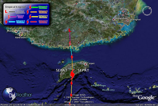
Super Typhoon SEPAT struck China's coase killing 15 and forcing the evacuation of 90,ooo.


We'll keep you posted!

RS

Saturday, August 18, 2007

Hurricane Dean

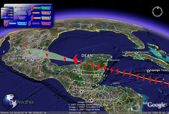
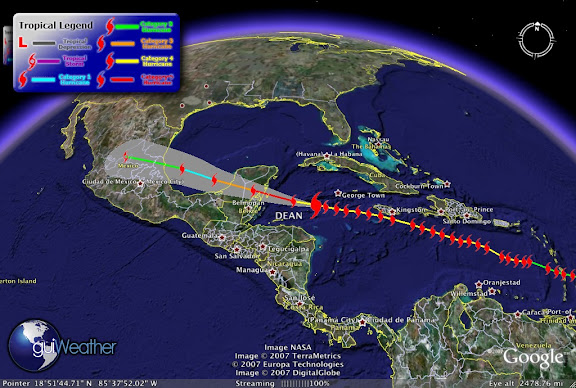
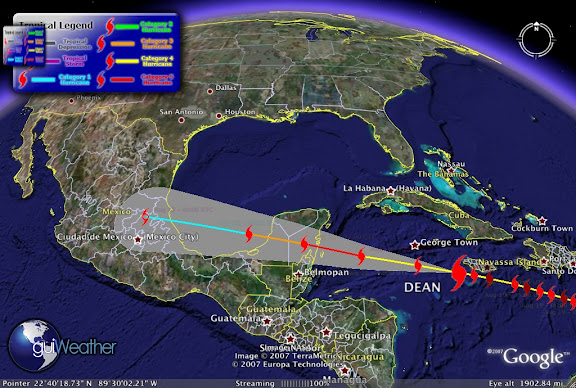
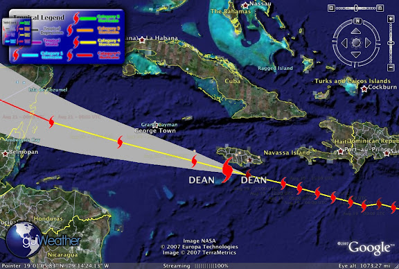
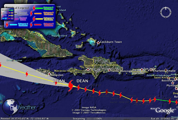
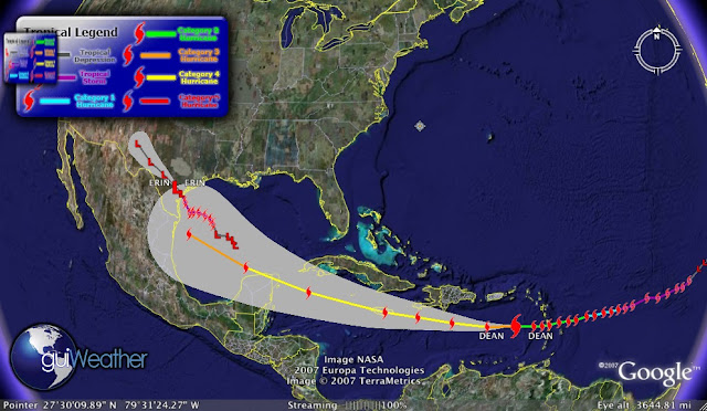
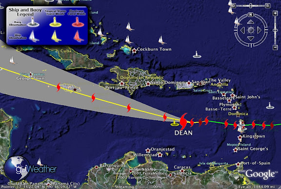
Its going to be a interesting weekend, especially with Hurricane Dean, now a CAT 4 on the move. We are going to follow the storm straight through the weekend. To top that we are going to tacking this storm with guiWeather by Google. The image on the left if Dean's projected path.

As we went to blog, Hurricane Dean is currently a Category 4 Hurricane, with maximum winds of 150 mph and a pressure of 930 mb, .27.46 inches. Dean was 700 miles, 1125 km east-southeast of Kingston, Jamaica and about 239 miles, 390km, south of San Juan, Puerto rico, moving west at about 18 mph (30 kph) at Latitude: 15.0 N, Longitude: -66.7 W. The National Hurricane Center predicted Dean may grow to a Category 5 storm the highest level on the five-step Saffir-Simpson scale, with 150 mph (240 kph) winds as it tracks across Jamaica to the Gulf, home to a third of U.S. domestic crude oil and 15 percent of natural gas production. Dean is following almost the same path as Hurricane Rita, though some at the NHC speculate that Dean will weaken some as it approaches the US Gulf.


Aug 18 - 05:50 UTC - Weather buoy- 42059 (Image above), which lies in the direct path of Dean reported currently, Temperature: 81°F, Dewpoint: 75°F. Wind: NNE at 45 mph gusting to 54. Pressure: 999 mb. Wave Height: 26 ft .. Now remember just because the buoy is reporting waves at 26ft does not mean that these waves are not higher on average.


(Sat Photo GOES 1 Hurricane Dean)

According to press reports,

"Dean, the first hurricane of what is expected to be an above-average Atlantic season, lifted the roof off the pediatric wing at Victoria Hospital in St Lucia's capital, Castries, but patients had already been moved, officials said.

Heraldine Rock, an ex-government minister in the former British colony of 170,000 people, said the storm ripped roofs off houses and damaged at least two banana plantations.

"In one village, telephone and power lines are down, they're strewn all over the road, trees are uprooted and are blocking the roads," she said. "In another village, a landslide has been reported, cutting off any access to the airport."

Deputy Prime Minister Leonard Montoute said at least two people were injured when a tree fell on their house.

"I'm told that the coastal areas have taken a severe battering, there's debris all over Castries in the capital and flood waters on the roads," he said.

On neighbouring Martinique, an elderly man died of a heart attack during the storm and six people were injured, according to France's state office for overseas territories. Electricity company EDF said 95 per cent of homes were without power."


(Sat Photo by QuikSCAT of Hurricane Dean)

In this video shot on Antigua, Hurricane Dean's eye was some 100 miles away, but watch the wave action.


And then we have Dominica...


Here is some AP footage of Dean blowing through the eastern Caribbean Islands of St. Lucia and Martinique.


Let's not forget Super Typhoon SEPAT!


This Hurricane Dean has potential to cause some real damage along the Gulf Coast, hope we are prepared this time. Just a interesting note in hurricane history. Maybe with a little luck, Hurricane Dean will turn and follow the same track as its 1989 name sake "Hurricane Dean" did. So keep posted... Enjoy your weekend!

RS

Friday, August 17, 2007

Three new radars to boost weather warning system

Three new radars to boost weather warning system

A new radar system will make predicting severe weather easier in the Waikato, the MetService says.

The Government has approved funding for three new radars around the North Island. The first will be installed at New Plymouth airport next June.

MetService spokesman Bob McDavitt said the new radars would give them more accurate and faster information about pending weather patterns.

The other two radars will be installed in Gisborne and the Bay of Plenty. Specific sites and dates have not yet been confirmed but they will be installed within the next three years.

The radars will cost about $10 million.

Mr McDavitt said severe thunderstorms caused significant damage very quickly, but the new radars would enable smaller and isolated towns to get plenty of warning before storms hit.

Radars were the only way to track the path and progress of tornadoes and thunderstorms.

"You could get a text about a hail storm about to come," he said. "Then you can adjust your activities to meet the message. You wouldn't drive your car down to the supermarket then."

Mr McDavitt said having more radars would have been useful during the recent Taranaki tornadoes.

"We could have told people accurately when they would clear. There would have been more information to give."

The North Island now has two radars - one in Auckland and one in Wellington.

These radars cover only 25 per cent of the North Island. The three new radars will increase coverage to 80 per cent.

"It will make weather warnings more accurate. We'll be able to warn civil defence (units) if evacuations need to be made."

The regional council Environment Waikato emergency management officer Adam Munro said the radar in Taranaki "will greatly enhance EW's existing flood warning capability, by enabling the real time tracking and monitoring of severe weather systems coming into the Waikato".

Mr McDavitt expected the technology to be fully operational within 10 years and hoped to get "everything in place" for the 2011 Rugby World Cup.

Weather Story

Hurricane Dean


Tropical Depression Erin

Erin Weakens to Tropical Depression; Torrential Rain Heads Toward Flood-Weary Parts of Texas

By ELIZABETH WHITE

The Associated Press

CORPUS CHRISTI, Texas

Tropical Storm Erin made landfall Thursday as a tropical depression, bringing torrential downpours to Houston before aiming at flood-weary central Texas.

One person was killed and another was injured when a waterlogged roof collapsed at a storage unit at a Houston grocery store, Houston Fire Chief Omero Longoria said.

Erin came ashore at about 7 a.m. at Copano Bay, about 25 miles northeast of Corpus Christi.

"We're very fortunate. We're always prepared for the worst and we pray that we're wrong," said Corpus Christi Fire Department Deputy Chief Michael Hernandez. "For the most part it looks like we dodged a bullet." (See Storm Erin Deluges Houston)

Super Typhoon SEPAT


RS