Wednesday, September 10, 2008

Global Sea-Rise Levels By 2100 May Be Lower Than Some Predict

Global Sea-Rise Levels By 2100 May Be Lower Than Some Predict

Despite projections by some scientists of global seas rising by 20 feet or more by the end of this century as a result of warming, a new University of Colorado at Boulder study concludes that global sea rise of much more than 6 feet is a near physical impossibility.

Tad Pfeffer, a fellow of CU-Boulder's Institute of Arctic and Alpine Research and his colleagues made calculations using conservative, medium and extreme glaciological assumptions for sea rise expected from Greenland, Antarctica and the world's smaller glaciers and ice caps -- the three primary contributors to sea rise. The team concluded the most plausible scenario, when factoring in thermal expansion due to warming waters, will lead to a total sea level rise of roughly 3 to 6 feet by 2100.

A paper on the subject was published in the Sept. 5 issue of Science. Co-authors of the study were of the University of Montana's Joel Harper and Shad O'Neel of the Scripps Institute of Oceanography at the University of California, San Diego. The study was funded by the National Science Foundation and a University of Colorado Faculty Fellowship.

"We consider glaciological conditions required for large sea level rise to occur by 2100 and conclude increases of 2 meters are physically untenable," the team wrote in Science. "We find that a total sea level rise of about 2 meters by 2100 could occur under physically possible glaciological conditions but only if all variables are quickly accelerated to extremely high limits."

"The gist of the study is that very simple, physical considerations show that some of the very large predictions of sea level rise are unlikely, because there is simply no way to move the ice or the water into the ocean that fast," said Pfeffer.

The team began the study by postulating future sea level rise at about 2 meters by 2100 produced only by Greenland, said Pfeffer. Since rapid, unstable ice discharge into the ocean is restricted to Greenland glacier beds based below sea level, they identified and mapped all of the so-called outlet glacier "gates" on Greenland's perimeter -- bedrock bottlenecks most tightly constraining ice and water discharge.

"For Greenland alone to raise sea level by two meters by 2100, all of the outlet glaciers involved would need to move more than three times faster than the fastest outlet glaciers ever observed, or more than 70 times faster than they presently move," said Pfeffer. "And they would have to start moving that fast today, not 10 years from now. It is a simple argument with no fancy physics."

In Antarctica, the majority of ice entering the ocean comes from the Antarctic Peninsula and the Pine Island and Thwaites glaciers, said Pfeffer. Most of the marine-based ice in West Antarctica is held behind the Ross and Filcher-Ronne ice shelves, which Pfeffer's team believes are unlikely to be removed by climate or oceanographic processes during the next century. The researchers used varying glacier velocities to calculate sea-rise contribution estimates from the Antarctic Peninsula, Pine Island and Thwaites glaciers.

The team also used assessments of the world's small glacier and ice cap contributions to sea level rise calculated by a CU-Boulder team and published in Science in July 2007. That study indicated small glaciers and ice caps contribute about 60 percent of the world's ice to oceans at present, a percentage that is accelerating.

Considering all major sources of sea level rise, including Greenland, Antarctica, smaller glaciers and ice caps and the thermal expansion of water, the team's most likely estimate of roughly 3 to 6 feet by 2100 is still potentially devastating to huge areas of the world in low-lying coastal areas, said Pfeffer.

Some scientists have theorized that continuing warming trends in Greenland and Antarctica could warm the Earth by 4 degrees F over the present by 2100. The last time that happened, roughly 125,000 years ago during the last interglacial period, glacier changes raised sea level by 12 to 20 feet or more. But the time scale is poorly constrained and may have required millennia, Pfeffer said.

"In my opinion, some of the research out there calling for 20 or 30 feet of sea rise by the end of the century is not backed up by solid glaciological evidence," said Pfeffer.

Policymakers need to be able to predict sea level accurately if communities, cities and countries around the world are going to be able to plan effectively, Pfeffer said. "If we plan for 6 feet and only get 2 feet, for example, or visa versa, we could spend billions of dollars of resources solving the wrong problems."

Note: This story has been adapted from a news release issued by the University of Colorado at Boulder

IKE TRACK

tab Eastern Pacific tab tab Atlantic tab
tab
Click for Eastern Pacific
TC Activity

Emergency personnel offer advice on preparing for disasters

Barrow County Fire and Emergency Services have joined with the Department of Homeland Security in marking September as National Preparedness Month.

If every family in Barrow County looks at becoming better prepared, the damages and loss of life from a disaster can be reduced, according to local officials.

“Being prepared is very important in a disaster no matter how big or small,” said Lt. Scott Dakin, public information officer. “The better prepared a citizen is the more they increase their chances of surviving a disaster. It also will help in recovering from such an event.”

One way that Barrow County Fire and Emergency Services prepares for disasters is by participating with the Barrow County Emergency Management Agency (EMA).

There are two personnel that serve as officers with the EMA. Assistant chief Mark Melvin is the deputy director and Lt. Ernest Weant is the operations officer. Both personnel have taken extensive training to become certified emergency managers.

The Barrow County Emergency Management Agency is a local organization that serves to prepare and assist in the protection of life and property in the event of a natural or man made disaster. This is accomplished through the process of preparedness, response, recovery and mitigation.

Another group that the department participates in is the Barrow County Citizens Corp Council.

Assistant chief Mark Melvin serves as the head of the council, and Lt. Ernest Weant and Lt. Scott Dakin also serve on the council.

The Citizen Corps Council works with the EMA and other public safety departments to establish volunteers to assist with disaster mitigation. One of the volunteer organizations that falls under the Citizens Corp is the Community Emergency Response Team (CERT).

CERT is a group of trained volunteers that can assist in different ways to mitigate disasters and other ways to assist public safety. The current CERT classes will have seven different personnel from fire and emergency Services participating as instructors for the class.

One type of natural disaster that citizens of Barrow County need to prepare for is tornados. Jackson and Hall counties were recently hit by tornadoes from the effects of Tropical Storm Faye. With this in mind, it is important for citizens to be prepared and alert for tornadoes. It is also important to know the terms used by the Weather Service.

When Barrow County is under a tornado watch it means that tornadoes are possible. Citizens should watch the sky for approaching storms and monitor the radio or television for updates.

When a tornado warning is issued, it means that a tornado has been spotted or is indicated by weather radar. If Barrow County goes under a tornado warning, citizens should immediately seek shelter. It is important to have a plan in place before a tornado warning is issued.

Every family in Barrow County should have a disaster plan that includes what to do in the event of a tornado or tornado warning.

This tornado plan should include where to go for shelter in a building or if caught outside. As part of your plan, you should also include what family members should do after a tornado has occurred. You should answer questions such as how to contact each other if family members become separated, where you would stay if your home is damaged by a tornado, and many other questions.

“A family disaster plan will help in reducing the damage and stress that a disaster can place on your family,” Dakin said. “It is much better to be prepared before a disaster occurs, than to try to determine what to do when a disaster occurs.”

For more information on developing your family’s disaster plan, visit the Federal Emergency Management Agency at www.fema.gov or www.ready.gov for information about planning from the Department of Homeland Security.


RS

Tuesday, September 9, 2008

Warmer ocean leads to fiercer hurricanes

Warmer ocean leads to fiercer hurricanes

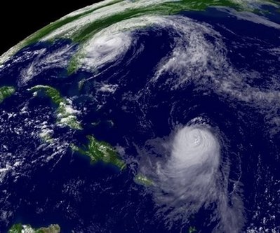
Hurricanes have grown more and more powerful over the past 30 years as ocean surface temperatures - probably aided by global warming - have increased, climate scientists said today.

The trend is worldwide, the researcher said, but the evidence is strongest in the North Atlantic, which takes in the Caribbean and the Gulf of Mexico, where just days ago Hurricane Gustav bore down on the Louisiana coast, reviving memories of Katrina.

"The fact that Gustav reached Category 4 in the increasingly warm Caribbean is consistent with what we've noted as a trend over the past 30 years," James B. Elsner, leader of a hurricane research team at Florida State University, said Wednesday in an e-mail.

The one-two punch of Gustav and of Katrina, the Category 5 hurricane that devastated New Orleans just three years ago, he said, "might be a harbinger of things to come in a warmer world as the observed and modeled consequence of climate change."

The study is appearing today in the journal Nature just a day after two other published reports concluded that for the past decade temperatures throughout the Northern Hemisphere have been warmer than at any time in the past 1,300 years.

Surface temperatures both on land and sea have been rising for centuries, and when ocean surfaces heat up they provide energy that can whip the circular winds of normal storms over the ocean into full-scale hurricanes.

Using satellite measurements, Elsner and researchers at the University of Wisconsin studied the peak wind speeds of storms over the world's tropic oceans that later grew to become hurricanes.

The result, they said, was consistent with the long-held hypothesis that "as the seas warm, the ocean has more energy to convert to tropical winds." More often now than in the past, those winds have speeded up to become hurricanes, Elsner's team has found.

The link between those hurricanes and sea surface temperatures during the past three decades was most clear in the North Atlantic, but it was less significant in other parts of the world, the scientists concluded.

In an earlier review of the links between climate change and hurricane intensity, published in the journal Geophysical Research Letters, Elsner noted that his results "have serious implications for life and property throughout the Caribbean, Mexico and portions of the United States."

The Elsner report follows reports by Peter Webster, Judith Curry and their colleagues at Georgia Institute of Technology who, after studying the increasing intensity of hurricanes and their links to rising sea surface temperatures, concluded in a report published in Science that hurricane intensities worldwide have more than doubled since 1970.

Hurricane intensity is measured on what is called the Saffir-Simpson scale. The weakest are Category 1, in which winds reach from 74 to 95 mph, and the strongest are Category 4, with sustained winds from 131 to 155 mph, and Category 5, such as Katrina, with winds of 156 mph or more.

In the 35 years before 2004, the number of Category 1 hurricanes that reached Category 4 or 5 rose worldwide from 17 percent to 35 percent, they reported. In an e-mail Wednesday, Curry said that some 41 percent of all Category 1 hurricanes have increased to Category 4 or 5 in the past five years.

"This increase is associated with the trend of increasing sea surface temperatures associated with global warming, although the link with sea surface temperature is more complex than originally thought," Curry said.

Referring to Hurricane Gustav, Curry cautioned that "you can't attribute the intensity of any single storm to global warming."

HURRICANE IKE!

tab Eastern Pacific tab tab Atlantic tab
tab
Click for Eastern Pacific
TC Activity

WEATHER NOTE

My good friend at Freaque Waves has a very interesting story that we ll need to take a look at.

Caused by a freaque set of waves


This news from the Bay of Plenty Times, the newspaper of Bay of Plenty region of the North Island of New Zealand, entitled "Chopper rescues man after boat tips" by Vicki Waterhouse. Here's the essence of the story:

The skipper of a Coastguard boat nearly drowned yesterday after a rogue set of waves overturned the boat when it suddenly lost power.
And here's what happened:

Waihi Beach Coastguard spokesman Noel Haszard said the skipper was sent out to help with communication difficulties between headquarters and the crew on the beach, which was trying to recover the beacon.

The man was driving a Waihi Beach Coastguard jet boat when he saw the waves approaching.

"Four in a row hit him, the first wave hit the vessel and he went over the top of it and then ... he lost power for some reason."

"With a jet boat once you lose power you're history, so it rolled him, and it was all over from there."

The skipper managed to trigger the boat's EPERB (Emergency Personal Beacon), which he spotted in the water.

"We lost the boat but we didn't lose the skipper and that's the important thing," Mr Haszard said.

Read the rest.....


RS

Monday, September 8, 2008

UPDATE : Hurricane Ike weakens as it batters Cuba

Hurricane Ike weakens as it batters Cuba

Hurricane Ike weakened to a Category 2 storm after making landfall in northeastern Cuba, the U.S. National Hurricane Center in Miami reported Monday.

The storm churned ashore as a dangerous Category 3 storm but forecasters said the hurricane was losing strength as it moved west across Cuba.

Ike has torn apart houses and knocked over trees along the northern coast of Cuba. More than 770,000 Cubans have been forced to leave their homes.

Forecasters said the storm hit Cuba's Holguin province at 9:45 p.m. ET Sunday and is expected to reach central Cuba later Monday and western Cuba on Tuesday.

The centre said the hurricane is dumping heavy rain on parts of Cuba and causing "large and dangerous battering waves" along the coast.

A hurricane warning was in effect on Monday for Cuba from Guantanamo province westward even though the storm is expected to weaken further.

According to BBC News on Monday, a number of homes along Cuba's northern coast have been destroyed by the storm.

Ike is expected to skirt the Florida Keys on Tuesday as it heads into the Gulf of Mexico.

A tropical storm warning was issued for the Florida Keys as of early Monday. The centre reported that the storm had maximum sustained winds close to 165 kilometres per hour at 5 a.m. ET.

Authorities are blaming Hurricane Ike for at least 58 deaths in Haiti.

The hurricane slammed into the Turks and Caicos Islands Saturday night as an "extremely dangerous" Category 4 storm.

It reportedly damaged about 80 per cent of homes on Grand Turk, the main island in the Turks and Caicos, said Premier Michael Misick.

Authorities are warning residents who live along the Gulf from Florida to Mexico to monitor Ike's progress.

LATEST TRACK


Click to zoom in – GIS Users click here [Image of probabilities of tropical storm force winds]


Click image to zoom in – GIS Users click here [Image of probabilities of hurricane force winds]


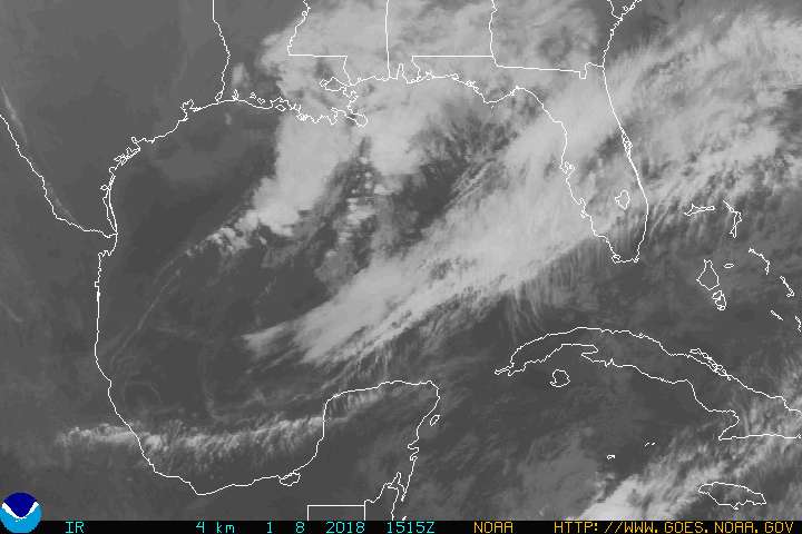
http://www.goes.noaa.gov/GIFS/GULFIR.JPG


RS

Hurricane Ike heads for Cuba

Hurricane Ike heads for Cuba

HAVANA (Reuters) - Hurricane Ike killed at least 37 people in Haiti and ripped off rooftops in the southern Bahamas on Sunday as Cuba scrambled to get hundreds of thousands out of the path of a storm headed toward the U.S. Gulf oil patch and possibly New Orleans.

Despite weakening slightly, Ike was still a dangerous Category 3 hurricane with 120 mph (195 kph) winds and a possible 12-foot (3.6-metre) storm surge.

It bore down on Cuba's coast after dumping more heavy rain on Haiti and raging through Britain's Turks and Caicos, and Great Inagua, the Bahamas' southernmost island.

"This one is quite severe," said Inagua resident Shanie Roker. "There is a lot of wind and rain. Roofs in Matthew Town are being damaged and trees are coming down."

Residents of the Florida Keys, a 110-mile (177-km) island chain connected by bridges with only one road out, were told to evacuate as a precaution.

Ike could follow a path similar to Hurricane Gustav through the Gulf of Mexico toward Louisiana and Texas. It may threaten New Orleans, the city swamped by Hurricane Katrina three years ago, and the Gulf energy rigs that account for a quarter of U.S. oil output and 15 percent of natural gas output.

The hurricane rained new misery on Haiti. Authorities said at least 37 people, including 13 children, were killed by floods triggered by Ike in Cabaret, a town north of the capital, Port-au-Prince.

"The whole village is flooded," civil protection official Moise Jean-Pierre said. "The death toll could go higher."

Flooding from Tropical Storm Hanna last week was believed to have killed at least 500 people around the port city of Gonaives.

On Sunday, rain from Ike was causing the La Quinte river to rise again and floodwaters were seeping back into Gonaives, Mayor Stephen Moise said. All of the bridges linking the city to the rest of the country had collapsed.

"Gonaives is really a devastated and isolated city," he said. "We cannot bear another hurricane."

PATH ACROSS CUBA

In the neighbouring Dominican Republic, a 60-year-old man was killed by a falling palm tree and some 41,000 people were driven from their homes by rain and gusty winds.

Many of Cuba's 11 million people could be affected by Ike, which was expected to hit land north of Guantanamo Bay -- home to the controversial U.S. prison camp for terrorism suspects -- and spend nearly two days over the long, narrow island.

By 5 p.m. EDT (10:00 p.m. British time), the centre of Ike was 75 miles (120 km) north-northeast of Guantanamo.

Authorities used buses, trucks and other transportation to move thousands of tourists inland from Cuba's prime resorts along the northern coast. Ranchers herded cattle in grazing areas of eastern Las Tunas and Camaguey to higher ground.

Ike was set to come ashore in Holguin, home of the nickel industry, Cuba's most important export, then move westward over the heart of the sugar industry. Holguin's mines and three processing plants in the mountains were shut down.

Holguin and neighbouring provinces have not been hit by a storm of Ike's power in more than 50 years.

"I've never seen a hurricane pass over this city and I'm terribly frightened," university student Yaneisy Betancourt said by telephone from the port city of Nuevitas.

The storm hit the eastern islands of the Turks and Caicos as a Category 4 storm with 135 mph (215 kph) winds, damaging 80 percent of the houses on Grand Turk, home to about 2,500 of the islands' 22,000 residents, government spokesman Courtney Robinson said.

"There's a lot of flooding. Power lines are down. Communications lines are out," he said.

In the Florida Keys, a steady stream of traffic moved along the Overseas Highway as some people evacuated even though Ike was expected to pass at least 100 miles (160 km) to the south.

Ike was forecast to curve into the Gulf in the wake of Gustav, which went ashore just west of New Orleans last week, sparing the city traumatized by Katrina in 2005.

Katrina killed 1,500 people and caused about $80 billion damage on the U.S. Gulf Coast.

Ike's most likely track had it aimed at the Texas-Louisiana border. But long-range forecasts have a large margin of error and any deviation could take it toward New Orleans.

Forecasters expected Ike to weaken to a Category 1 storm on the five-step Saffir-Simpson intensity scale over Cuba but to regain Category 3 strength as it nears the U.S. Gulf coast.

Oil companies had begun returning workers to the offshore platforms that were evacuated before Gustav hit but began preparing for the arrival of Ike.

(Additional reporting by Joseph Guyler Delva in Port-au-Prince, Michael Haskins in Key West, John Marquis in Nassau and Manuel Jimenez in the Dominican Republic; Writing by Jim Loney; Editing by Tom Brown and John O'Callaghan.

James Wilson & Mark Avery, Meteorologists, The Weather Channel
5:29 a.m. ET 9/7/2008

Category 4 Hurricane Ike (135 mph) is a potentially deadly hurricane. It is slamming the southern Bahamas.

Tropical Storm Hanna has traveled from Myrtle Beach to Boston producing locally flooding rains and occasionally damaging tropical storm-force winds during its trek up the East Coast. Hanna has now lost tropical characteristics, and the National Hurricane Center has issued its last advisory on Hanna.

Map of current winds and gusts.

Watch the latest hurricane forecast.

Hurricane Ike

Northerly shear and some slight dry air entrainment enabled Ike to weaken just a touch on Saturday morning. Maximum sustained winds near the center lowered to 110 mph early Saturday, but reintensified quickly by Saturday afternoon and evening. Maximum sustained winds are back up to 135 mph; a dangerous Category 4 hurricane.

As of 5 a.m. ET, Ike was located about 65 miles east of Great Inagua Island.

View the Ike Tracker here.

Hurricane Ike is currently moving just south of due west at 15 mph. Ike is now moving away from the Turks and Caicos Islands and towards Great Inagua Island with powerful winds and waves and eventually all of the southeastern Bahamas this morning.

Residents and tourists should have already taken the necessary precautions to protect life and property and prepare for the arrival of what will likely be a life-threatening Category 4 hurricane.

You can view the projected path here.

Hurricane warnings are posted for the central and southeastern Bahamas and the Turks and Caicos, as well as eastern Cuba, while a hurricane watch is posted for central Cuba (the provinces of Villa Clara, Cienfuegos, and Sancti Spiritus) and Andros Island in the Bahamas. A tropical storm warning is in place for the the northern coast of the Dominican Republic and Haiti.

After passing through the Bahamas, the next landmasses in front of Ike will be Cuba and possibly the Florida Keys.

Some of the latest model track guidance points to a potential path that would take Ike across Cuba, on a east to west track. Although this is not a good outcome for Cuba, it would be a positive outcome for south Florida and the Florida Keys. The center of Ike would stay south of Florida and the interaction with Cuba would allow Ike to weaken significantly.

Still, there is another possibility that Ike will scrape the northern Cuba coast and move through the Florida Straits; keeping most of its strength.

Residents and tourists alike should pay close attention to the progress and forecast track of Ike. This is a very dangerous and potentially deadly hurricane and bears close watching.

After its passage near Cuba and the Florida Straits, Ike is then forecast to turn into the central or eastern Gulf of Mexico. Interests along the Gulf Coast should pay close attention to Ike's projected path.

Tropical Storm Hanna

At around 3:15 a.m. EDT Saturday morning, Hanna made landfall near the South Carolina/North Carolina border producing tropical storm-force winds gusts (occasional hurricane force) with some locations experiencing sustained tropical storm-force winds.

Here is a short list of some notable gusts:
Kure Beach, NC: 77 mph
Wrightsville Beach, NC: 72 mph
Annapolis, MD: 54 mph
North Myrtle Beach, SC: 53 mph
Wilmington, NC: 54 mph
North Wildwood, NJ: 51 mph
Carolina Beach, NC: 50 mph

After making landfall, Tropical Storm Hanna moved up the East Coast and has now moved off the New England Coast and lost its tropical characteristics.

Hanna's top maximum winds are at 50 miles per hour.

View the Hanna Tracker.

Hanna continues to motor to the northeast at about 33 mph. It has spread heavy rain and windy conditions throughout portions of the mid-Atlantic and Northeast. D.C., Philadelphia, and New York have all experienced fairly heavy rain from the midday hours and through the afternoon and early evening on Sunday. Many rainfall amounts over 5 inches have been reported, with a few over 8 inches. There have been numerous reports of local street/highway, urban, apartment, residential flooding in Hanna's wake along the East Coast.

Here's a look at the rolling 24-hour rain totals due to Hanna.

For the latest updates stay tuned to The Weather Channel and click on weather.com.

LATEST TRACK

Mariners' 1-2-3 Rule

Click image to zoom in [full basin map of tropical cyclone activity]


5th ANNUAL NATIONAL PREPAREDNESS MONTH WASHINGTON -

The U.S. Department of Homeland Security announced today that more than 1,200 national, regional, state and local businesses and organizations have pledged their support and joined the 2008 National Preparedness Month Coalition. Sponsored by the department's Ready Campaign, National Preparedness Month helps to raise awareness and promote action by Americans, businesses, and communities on emergency preparedness.

"As we approach our fifth National Preparedness Month, I want to thank the hundreds of coalition members who are making a difference in their communities by helping raise the basic level of preparedness in our country," said Homeland Security Secretary Michael Chertoff.
"Individual preparedness is the cornerstone of emergency preparedness. Experience shows that if Americans take steps ahead of time, they stand a much better chance of coming through an emergency unharmed and recovering more quickly."

The Ready Campaign and Citizen Corps (www.citizencorps.gov) are specifically encouraging individuals across the nation to take important preparedness steps. These steps include: getting an emergency supply kit, making a family emergency plan, being informed about the different emergencies that may affect them, as well as taking the necessary steps to get trained and become engaged in community preparedness and response efforts.

National Preparedness Month Coalition members have agreed to distribute emergency preparedness information and sponsor activities across the country that will promote emergency preparedness. Membership is open to all public and private sector organizations. Groups and individuals can register to become members by visiting www.ready.gov, and clicking on the National Preparedness Month banner.

Senate Homeland Security and Governmental Affairs Committee Chairman Joseph I. Lieberman and Ranking Member Susan M. Collins, along with House Homeland Security Committee Chairman Bennie G. Thompson and Ranking Member Peter T. King, will serve as honorary Congressional Co- Chairs of National Preparedness Month 2008. Together, they will lead
the effort to increase public awareness about the importance of emergency preparedness on Capitol Hill and throughout the country.

For more information on the Ready Campaign and National Preparedness Month, please visit www.ready.gov or www.listo.gov. Information is also available by phone at 1-800-BE-READY or 1-888-SE-LISTO.

February 2008 marked the Ready Campaign's fifth year at the Department of Homeland Security. Launched in 2003 in partnership with The Advertising Council, Ready is designed to educate and empower Americans to prepare for and respond to emergencies, including natural disasters and potential terrorist attacks. It has proven to be one of the most successful campaigns in Ad Council's more than 65- year history. Since its launch, the campaign has generated more than $703.2 million in donated media support. Individuals interested in
more information about family, business and community preparedness can visit www.ready.gov or call 1-800-BE-READY to receive free materials.

Linking up with the Ready.gov people and participating in September's National Preparedness Month, is an easy win. The federal people are already doing all the hard work. All you really have to do is sign up. Most clubs and ARES groups are already doing activities which fit into their structure, so why not get credit for your actions? Of course if you do something more with this opportunity, so much the better! But you have to sign your group in and no one can do that for you. There are hundreds of ARES groups and clubs in the country.

Wouldn't it be fun to have even 70% of them sign up and get noticed? Go to www.ready.gov, and click on the National Preparedness Month banner.


RS

Saturday, September 6, 2008

US east coast braces for deadly Hanna, Hurricane Ike nears

US east coast braces for deadly Hanna, Hurricane Ike nears

MIAMI (AFP) — Tropical Storm Hanna closed in on the US east coast Friday on the verge of hurricane strength after leaving 136 dead in Haiti, as powerful Hurricane Ike threatened Caribbean islands and the United States.

A major rain-generator, Hanna churned through the Bahamas en route to the US Atlantic coast, prompting emergency preparations along more than 1,600 kilometers (1,000 miles) of coastline before its expected arrival late Friday, after unleashing flooding and landslides in Haiti that left thousands homeless and as many as 200,000 with little or no food or water.

The Miami-based National Hurricane Center (NHC) forecasts the storm will crash ashore near North or South Carolina and race up the US east coast, potentially affecting tens of millions Americans along the eastern seaboard.

Heavy rain, wind and high surf were forecast along the southeastern coast ahead of the storm's arrival as governors in North Carolina and Virginia declared states of emergency. South Carolina Governor Mark Sanford called for voluntary evacuations in two counties threatened by the storm.

Packing sustained winds near 110 kmh (70 mph), at 2100 GMT Friday, the center of the storm was about 255 kilometers (160 miles) south-southeast of Charleston, South Carolina, and moving north at around 32 kilometers (20 miles) per hour, the NHC said.

"The center of Hanna should cross over the southeastern coast of the United States (late Friday) or early Saturday, then move along the mid-Atlantic coast later Saturday and Sunday night," according to an NHC advisory.

"Although no significant change in strength is forecast before landfall, it would take only a small increase in wind speed for Hanna to become a hurricane."

A hurricane watch remained in effect for parts of the North and South Carolina coast and tropical storm watches extended as far north as Massachusetts as authorities prepared for possible flooding and kept a wary eye on a more formidable storm, Hurricane Ike, out in the Atlantic.

Ike was forecast to spare Haiti as it plowed across the Atlantic while the Caribbean nation struggled to recover from devastating flooding from Tropical Storm Hanna which killed 136 and stranded hundreds of thousands.

"At least for now" Haiti looks likely to be spared yet another hit, NHC spokeswoman Karina Castillo said.

But the poorest country in the Americas is still reeling from the devastation inflicted by a succession of three storms in as many weeks that killed more than 250 people in total.

The country's third largest city Gonaives remained largely under water following Hanna, and Senator Yuri Latortue who represents the city called the situation "catastrophic."

"I know perfectly well that the hurricane season has hit our entire country, but the situation in Gonaives is truly special, because now some 200,000 people there haven't eaten in three days," Latortue said.

A lifeline was extended to thousands of people in and around Gonaives Friday when a boat carrying tons of World Food Program relief supplies docked at the port, the WFP said.

Haiti's government pleaded for international aid, and the United Nations was in the process of launching an emergency appeal. Switzerland, France, the United States, the European Union and the Red Cross were among the countries and bodies to commit emergency relief.

While it may spare Haiti, Ike was on course to batter the Bahamas Saturday and Sunday before possibly slamming into Cuba, another island nation recently battered by this hurricane season's conga line of storms.

Ike is then forecast to make landfall in south Florida on Wednesday as a major hurricane, Castillo warned.

Densely populated south Florida, including the cities of Miami and Fort Lauderdale, has not been hit by a major hurricane since devastating Hurricane Andrew in 1992. Andrew was the costliest natural disaster in US history until it was topped by Hurricane Katrina in 2005.

Ike was downgraded slightly Friday but remained dangerous, the NHC said.

With sustained winds of 185 kilometers (115 miles) per hour, the hurricane over the western Atlantic was now a category three on the five-level Saffir-Simpson scale, but the center said Ike was still "expected to be a major hurricane as it nears the hurricane watch area."

As of 2100 GMT Friday, the eye of Ike was 745 kilometers (460 miles) northeast of Grand Turk Island and was moving west at about 24 kilometers (15 miles) per hour, the NHC said.

Ike and Hanna were part of a trio of storms in the Atlantic, with Tropical Storm Josephine churning in the eastern Atlantic off of Cape Verde.

The storms follow Hurricane Gustav, which ripped through the Caribbean then slammed the US Gulf Coast, and Tropical Storm Fay, which also pounded several Caribbean islands and made landfall in Florida four times, dumping record amounts of rain.

LATEST TRACKS

tab Eastern Pacific tab tab Atlantic tab
tab
Click for Eastern Pacific
TC Activity

HURRICANE TRACKING

storm pi

STAY TUNED
RS

Friday, September 5, 2008

Hurricanes Gustav and Hanna disrupt cruise plans in the Caribbean

Hurricanes Gustav and Hanna disrupt cruise plans in the Caribbean

If you plan to take a cruise anywhere in the Caribbean, Florida or the Gulf Coast this week, call your cruise line. Nearly all of them are changing itineraries, ports and departure dates. Expect major disruptions, not just because of Hurricane Gustav but also Hurricane Hanna right behind it.

Hanna, which raked the Turks and Caicos today and closed its airport, was upgraded from a storm to a hurricane this morning, and forecasters said it could head for the U.S. mainland.

So far, the weather is affecting nine ships at Carnival Cruises alone, as well as operations of Norwegian Cruise Line and Royal Caribbean International. And of course, if your departure or arrival date or port is changed, you may need new flights. Many airlines have temporarily loosened change penalties, but you have to act soon to take advantage of them.

Among cruise updates posted on websites:

Carnival
: Carnival Ecstasy will depart Galveston, Texas, on Wednesday instead of today, and shorten its trip from five days to three days. Carnival Fantasy will depart Mobile, Ala., on Wednesday instead of today. Guests can cancel for full refunds or take the cruises and get partial refunds based on missed cruise days, Carnival says. These and seven other ships are changing itineraries on cruises already underway, with several canceling calls on the Bahamas.

Norwegian: The Norwegian Spirit, which departed New York on Sunday for a six-day cruise, will call on Bermuda instead of the Bahamas. The Norwegian Sky, departing Miami today, originally for the Bahamas, will instead call on Cozumel, Mexico, and Key West, Fla.

Royal Caribbean International: Sovereign of the Seas and Majesty of the Seas, both departing today from Florida ports, will skip Coco Cay, the line’s private resort in the Bahamas, and instead call only on Nassau and Key West, Fla, according to an update today. Mariner of the Seas and Liberty of the Seas, which departed over the weekend, are also making itinerary changes.

Disney Cruise Line: The company today said it has not made any changes to the upcoming Disney Wonder voyage, which is due to leave Port Canaveral, Fla., on a three-night cruise to Nassau and Castaway Cay, Disney private resort in the Bahamas.

How similar are Hurricanes Gustav and Katrina?

Here's a comparison of Hurricanes Gustav and Katrina:

LANDFALL

Gustav: Monday, Sept. 1, 2008, about 10:30 a.m. EDT, near Cocodrie, La., about 70 miles southwest of New Orleans.

Katrina: Monday, Aug. 29, 2005, about 7:10 a.m. EDT, near Buras, La., about 55 miles south of New Orleans.

___

STRENGTH

Gustav: Reached Category 4, landfall as Category 2, winds near 110 mph.

Katrina: Reached Category 5, landfall as Category 3, winds near 125 mph.

___

STORM SURGE

Gustav: Reports of 12 feet high in the Industrial Canal, east side of New Orleans.

Katrina: Estimated at 27 feet high in Hancock, Miss. (It was difficult to measure in New Orleans because buildings washed away, leaving no high water marks.)

___

STORM TRACK

Gustav: Tropical storm forms Aug. 25, 2008, in the Caribbean, crosses Haiti, Cuba.

Katrina: Tropical storm forms Aug. 24, 2005, over the Central Bahamas, strikes southern tip of Florida.

___

LEFT BEHIND

Gustav: FEMA estimates 10,000 left in New Orleans.

Katrina: 30,000 people crowd Superdome, convention center. Others plucked from homes, rooftops.

Sources: National Hurricane Center, FEMA


HURRICANE TRACKING

storm pi

LATEST NHC TRACK

tab Eastern Pacific tab tab Atlantic tab
tab
Click for Eastern Pacific
TC Activity

Marine Portal

LIVE WEATHER CAMS

Daytona Beach cam
2.7 miles away
Daytona Beach cam


MARITIME NOTES

New Orleans – update

The US Coast Guard issued a Marine Safety Bulletin (MSB) stating that Captain of the Port Zone New Orleans remains at Port Condition ZULU. However, the Lower Mississippi River is open to shallow draft traffic (less than 12 feet draft) from Mile Marker 303 to Mile Marker 88 (in the vicinity of Algiers Lock). A second MSB states that a safety zone has been established in the Inner Harbor Navigation Canal to protect mariners from hazards associated with salvage operations. Entry into the IHNC is prohibited. A third MSB states that Port Condition ZULU has been lifted for all vessel traffic regardless of draft for the Lower Mississippi River from Mile Marker 20 Below Head of Passes to Mile Marker 303 Above Head of Passes. Vessels transiting from the Southwest Pass sea buoy to Mile Marker 20 Below Head of Passes are limited to a draft of 30 feet or less. (9/3/08).

Mobile & Pascagoula – update

The US Coast Guard issued a press release stating that the Port of Mobile is open to maritime traffic with a draft of 35 feet or less. The Port of Pascagoula is open to traffic with a draft of 12 feet or less. (9/3/08).

USCG – VTS Morgan City re-established

The US Coast Guard issued a press release stating that the vessel traffic service (VTS) at Morgan City, Louisiana has been re-established following passage of Hurricane Gustav. (9/3/08).

Florida – port conditions increased

The US Coast Guard issued a press release stating that port conditions for the Ports of Palm Beach and Fort Pierce have been increased to X-RAY due to the expected passage of Tropical Storm Hanna. (9/2/08).


Messing About In Ships Podcast


Storm Report


STAY SAFE!
RS

Thursday, September 4, 2008

Hurricane Hunter aircraft fly into the belly of the beast

Hurricane Hunter aircraft fly into the belly of the beast

As Hurricane Gustav strengthens into a monster, Hurricane Hunter aircraft fly round-the-clock into the thick of the storm and straight into the cauldron of its mysterious eye.

The (Fort Myers, Fla.) News-Press flew on the Hurricane Hunter Friday as Gustav developed from a youthful tropical storm into a mature, powerful hurricane with devastating potential to life and property.

During the Hurricane Hunter's flight we watched and spoke with the six-member crew, learned about their individual jobs, and rode in the cockpit with the pilots and navigator. Most of all, we broke through the roiling winds of the eye wall four times, to fly across its broad expanse and back out again.

The Hunter's wild and dangerous ride provides continuous, precise measurements of atmospheric conditions to the National Hurricane Center.

That allows the center, in turn, to more accurately predict the hurricane path and pinpoint specific areas that will have to issue mandatory evacuation orders. Increased accuracy saves unnecessary evacuation costs and the nerves of people who otherwise might have to leave their homes.

For most of the hunters, this is what they live for and are willing to die for. They have no parachutes, since it would be foolhardy to jump to safety amid hurricane winds. It's better to ditch the plane and rely on life vests, lifeboats and prayer to survive the high seas below.

The 53rd Weather Reconnaissance Squadron of the Air Force Reserve, a one-of-a kind unit flying into tropical storms and hurricanes since 1944, operates the Hunter.

The reservists are part of the 403rd Wing based at Keesler Air Force Base in Biloxi, Miss.

But Friday we flew from Homestead Air Reserve Base. When we began the flight at 11:15 a.m., Gustav's winds started off at 65 mph.

During the 10 1/2-hour flight, Gustav strengthened to a Category 1 hurricane at about 83 mph. Since we landed at 9:45 p.m. Friday, the storm has catapulted to a Category 4 hurricane at 150 mph.

Fasten your seat belts. It's going to be a bumpy ride.

8:30 a.m.: Meet the boss

We get to Homestead well before our designated arrival time and have a chance to speak with Maj. Jeff Ragusa, the deployed mission commander in charge of all hurricane operations flying from Homestead.

Nobody flies at the top of a hurricane, Ragusa said. "They want to know what happens at the bottom of it. If (National Oceanic and Atmospheric Administration) had its way, we'd fly four feet above the water."

Instead we're flying at 10,000 feet to find the maximum and most dangerous winds. The Hunter is a WC-130J aircraft, a newer model of the C-130, newly equipped with the Stepped-Frequency Microwave Radiometer, dubbed SMURF. The technology allows the Hurricane Hunters to constantly measure surface winds directly below the aircraft and helps increase the accuracy of the National Hurricane Center's forecasts by 30%.

The storm's circulation is already counter-clockwise, but no well-formed eye is apparent yet, Ragusa said. The Hunter's target is the western tip of Jamaica. We have to fly over Cuba to get there, and the State Department has to secure overflight permission from the Cuban government to do it.

The plane will fly in an X or Alpha pattern, going 105 miles out from the outskirts of the storm to its center, then back out again, repeating the pattern for all four quadrants of the storm.

"Every ride is a bumpy ride," Ragusa said. "As you walk through the aircraft, always keep an eye out for something to grab onto."

"And just remember, air sickness is just part of flying," said Lt. Col. Tom Davis, spokesman for Homestead Air Reserve Base.

9:25 a.m.: The briefing

Ragusa introduces the six-member crew at his pre-flight. They are:

• Lt. Col. C. Floyd Plash, aircraft commander and pilot

• Capt. Nate Gasscock, a pilot

• Lt. Col Dan Jones, pilot

• Capt. Eileen Bundy, aerial reconnaissance weather officer

• Mike Anderson, navigator

• Sgt. Major Justin Jones, the dropsonde system operator

The dropsonde is the major measurement instrument the crew uses to send information directly to the National Hurricane Center, like air pressure, wind speed and other data. The instrument is a small cylindrical device with a parachute on the end.

Once released from bottom of the aircraft, it floats down 2,500 feet a minute and sends back radio data, Jones said.

11:05 a.m.: Takeoff

The plane is massive, with the ability to plow through winds at more than 370 mph. But the storm is bigger.

The inside of the Hunter is like a giant, stripped-down tin can.

Its wiring and insulated pipes can be seen in the ceiling. The seats are simply red canvas benches lining either side of the plane with a back of red webbing — something to hang onto.

All the cargo is tied down, including cardboard boxes full of the dropsondes. Sgt. Major Justin Jones pulls out five of them in preparation, large cardboard cylinders wrapped in foil and pink bubble wrap.

The plane vibrates in place with its brakes on, as the four propeller engines are revved. Then it lurches forward at full speed on the bumpy runway.

The claw-like propellers become a blur. The noise inside is a steady, high-pitched hum. Davis distributes ear plugs.

The black nose cone lifts into the air.

Like a flight attendant, Jones signals the location of air sickness bags in little brown envelopes. He pulls one out and demonstrates the procedure.

The bathroom is at the back of the plane behind a green curtain.

1:25 p.m.: The flight

The Hurricane Hunter flies for about two hours, straight across the olive-green landscape of Cuba. The plane cuts between the cities of Cabaiguan and Moron, just skirting the city of Ciego De Avila.

As we come off the coast and head for Jamaica, just off Montego Bay, the turbulence starts. The massive WC-130J is buffeted like a toy, and the drops in altitude are sudden — about 200 feet at a time.

Jones ejects the dropsondes from the plane about every five minutes. Each one is tracked by a satellite frequency, its progress displayed by a colored graph on his computer monitor.

He said they cost $700 each, but the cost is worth the data they provide and the lives they save.

The hunter gets six different views of radar from cameras providing different angles. Another screen displays what all four engines are doing, from horsepower to oil pressure.

Above the emergency exit to the right of Jones' computer console is a sign that reads: "Ground and ditching use only."

The eye

The plane shakes and begins to go from side to side. We must be penetrating the eye wall for the first time, the roughest point of the trip.

Davis calmly munches on crackers from a plastic sandwich bag, then kicks back and closes his eyes for a few minutes.

The hurricane eye almost defies description by the human eye.

The eye may be the center of a deadly force of destruction, but witnessing its scope and majesty inspires awe. The massive ring of clouds forms the banks of a wide, empty lake of nothingness, save for a few scudding clouds.

Other images flood the mind: A white-coiled snake ready to strike. The crater of a volcano with puffs of cloud floating like steam. You can see through them below to the boiling blue lava of a stormy sea.

The eye changed each time we flew through it. At first its curve remained raggedy and incomplete. Then it formed into a rough circle about 25 miles across. By the forth and final pass-through, it became more defined — a smaller, tighter circle.

"Is that the eye wall? It had an inner spiral the last time. This could be the same thing," said Lt. Col. C. Floyd Plash, the mission commander, as the Hunter made the final pass-through at 7 p.m.

"Yeah, that's it," said Capt. Nate Gasscock, the pilot sitting beside him.

The job done —until their next shift 18 hours later, we flew home.

As the storm strengthens, the crews' shifts will shorten to six hours, then three hours round-the-clock instead of the standard 8-10 hours, said Lt. Col. Dan Jones, a pilot.

Why fly?

The crewmembers have different reasons for being here. They include patriotism, fulfilling a long-held dream, trying to conquer a childhood fear of severe weather or simply working near the place where their families live.

"Growing up, I was one of those kids who was afraid of weather," said Capt. Eileen Bundy, aerial reconnaissance weather officer.

So she went into meteorology and ended up flying into hurricanes, "making my mom real happy," she joked.

"It's getting pretty personal to me," Gasscock said. His wife as well as other families of crewmembers who live near the base in Biloxi will have to evacuate while they continue to fly.

But Gasscock knows the work is important to keep their families as well as hundreds of thousands of other residents safe.

When asked his motivation for being a Hurricane Hunter, Gasscock pointed to his jumpsuit sleeve where an American flag patch was sewn on. "Right there," he said.

LATEST TRACK ON HANNA

tab Eastern Pacific tab tab Atlantic tab
tab
Click for Eastern Pacific
TC Activity

Ike strengthens into major hurricane
Thu Sep 4, 2008 1:38am BST

By Joseph Guyler Delva

PORT-AU-PRINCE (Reuters) - Hurricane Ike strengthened rapidly into a major Category 3 hurricane in the open Atlantic on Wednesday and Tropical Storm Hanna intensified to a lesser degree as it swirled over the Bahamas toward the southeast U.S. Coast.

Hanna's torrential rains had already submerged parts of Haiti, stranding residents on rooftops and prompting President Rene Preval to warn of an "extraordinary catastrophe" to rival a storm that killed more than 3,000 people in the flood-prone Caribbean country four years ago.

Hanna was forecast to move over the central and northern Bahamas on Thursday, strengthening back into a hurricane with winds of at least 74 mph (119 kph) before hitting the U.S. coast near the North Carolina-Virginia border on Saturday.

Ike posed no immediate threat to land but strengthened explosively, growing in the space of a few hours from a tropical storm to a "major" Category 3 hurricane on the five-step Saffir-Simpson intensity scale.

Ike had top sustained winds of 115 mph (185 kph) as it swept across the open Atlantic 645 miles (1,035 km) east-northeast of the Leeward Islands, the U.S. National Hurricane Centre said.

It was forecast to strengthen further as it moved toward the southern Bahamas early next week but it was too early to tell whether it would threaten land, the forecasters said.

Tropical Storm Josephine also marched across the Atlantic on a westward course behind Ike but it had begun to weaken.

The burst of storm activity follows Hurricane Gustav, which slammed into Louisiana near New Orleans on Monday after a course that also took it through Haiti, where it killed more than 75 people.

The storms were troubling news for U.S. oil and natural gas producers in the Gulf of Mexico and for the millions of people living in the Caribbean and on America's coasts.

The U.S. government has forecast 14 to 18 tropical storms will form during the six-month season that began on June 1, more than the historical average of 10. Josephine was already the 10th of the year, forming before the statistical peak of the season on September 10.

The record-busting 2005 season, which included deadly Hurricane Katrina, had 28 storms.

'REALLY CATASTROPHIC'

In Haiti, officials were still counting the scores of people killed by Gustav when Hanna struck the impoverished nation on Monday night.

Authorities said Hanna caused flooding and mudslides that killed at least 61 people across Haiti, including 22 in the low-lying port of Gonaives. The death toll was expected to rise as floodwaters receded and rescuers reached remote areas.

"We are in a really catastrophic situation," said Preval, who planned to hold emergency talks with representatives of international donor countries to appeal for aid.

"It is believed that compared to Jeanne, Hanna could cause even more damage," he said, referring to a storm that sent floodwaters and mud cascading into Gonaives and other parts of Haiti's north and northwest in September 2004, killing more than 3,000 people.

Gonaives residents were still stranded on their rooftops two days after the floodwaters rose and the government did not know the fate of those who had been in hospitals and prisons.

"There are a lot of people on rooftops and there are prisoners that we cannot guard," Preval said.

Hanna had hovered off Haiti's coast since Monday, drowning crops in a desperately poor nation already struggling with food shortages. It also triggered widespread flooding in the neighbouring Dominican Republic.

The Miami-based hurricane centre said Hanna had begun moving northward and its top winds strengthened slightly to 65 mph (105 kph). It was forecast to turn northwest across the central and northern Bahamas in the next two days and then hit the U.S. coast in North Carolina and the mid-Atlantic states on Saturday.

It was too early to say where Ike might go, after it churns through the Caribbean, but the storm has drawn the attention of energy companies running the 4,000 offshore platforms in the Gulf of Mexico that provide the United States with a quarter of its crude oil and 15 percent of its natural gas.

By late Wednesday, Josephine was swirling over the far eastern Atlantic about 375 miles (605 km) west of the Cape Verde Islands. It was moving west but had begun to weaken, with top sustained winds dropping to 60 mph (95 kph).

LATEST IMAGES ON IKE

Enhanced Infrared Satellite Image of Hurricane Ike:

Hurricane Ike Satellite

Infrared Satellite Image of Hurricane Ike
:
Hurricane Ike Infrared Satellite

Visible Satellite Image of Hurricane Ike
:
Hurricane Ike Visible Satellite

Water Vapor Satellite Image of Hurricane Ike:
Hurricane Ike Water Vapor Satellite

Shortwave Satellite Image of Hurricane Ike
:
Hurricane Ike Shortwave Satellite

Dvorak Satellite Image of Hurricane Ike
:
Hurricane Ike Dvorak Satellite


RS