Wednesday, April 9, 2008

Hurricane forecasters' emergency network system going public

Hurricane forecasters' emergency network system going public

By Arlene Satchez
South Florida Sun-Sentinel"

It gave us the best opportunity to raise money and make it a viable business," said Norcross of the dealwith publicly traded Brampton.

Norcross, WFOR's hurricane specialist, will be company president and chief executive officer. With almost 40 years in broadcasting, he's experienced some of the frustrations caused by a communications disconnect among the media, government and the community during a disaster.

He became known in South Florida after delivering around-the-clock coverage when Hurricane Andrew hit sections of Miami-Dade County in August 1992.

Mayfield, who retired last year from the hurricane center, spent 34 years with the National Weather Service and is the hurricane specialist for WPLG-Ch. 10. He'll be senior vice president of government relations, working with emergency management agencies.

Despite the media's best efforts during a disaster, there are not enough reporters to cover all emergency operation centers in affected areas, Mayfield said.

The inability for emergency managers to communicate with the public or with other government agencies during disasters can hinder rescue or relief efforts.

Case in point: Hurricane Katrina in August 2005. The federal government's lack of response in devastated areas of the Gulf Coast immediately after the hurricane triggered national outrage.

The forecasters worked with Jackson, Miss.-based technology company Global Security Systems to develop blueprints for a communications network that is expected to fill crucial gaps in emergency management communications nationally.

Global Security's Alert FM system, a segment of the network, uses signals from local FM stations to transmit messages instantly to the community or a target audience. Information can also be sent as text or voice messages to mobile phones.

The communications network also will include a Web site with video footage and advisories from emergency management offices and other government agencies (free to the public) and a TV channel, broadcasting news conferences and other critical information.

Online segments of the network will be tested in April and May in nine emergency management locations, most of which will be in South Florida, and a new satellite system to broadcast videos should be running by June 1, in time for hurricane season, Norcross said.

To seal the deal, Brampton exchanged 100 million of its common stock shares. A recent $1 million private placement of Brampton shares will also be used to finance the emergency network and shareholders are expected to vote on the deal in June. Pending approval, the merged company will be renamed The AEN Group Inc.

"I believe the public will buy into this," Mayfield said. "It'll be my true legacy when all is said and done. I'm really committed to making it happen."

Arlene Satchell can be reached at asatchell@sun-sentinel.com or 954-356-4209.

WEATHER NOTES

Preparing for spring severe weather

By ALEX DOTY
Sentinel-Standard writer
Published: Monday, March 31, 2008 11:28 PM CDT

I
ONIA - April showers bring May flowers, but they can also bring severe weather that can have a negative impact on residents across Ionia County.

“I think everyone should be preparing for severe weather right now,” Ionia County Emergency Management Coordinator Rick Norman said.

According to information released from the State of Michigan, in 2007 there were 11 injuries and four deaths as a result of severe weather.
Additionally, severe weather resulted in about $150 million in property damage across the state during the same time period.

To prepare for this year's onslaught of potential severe weather, officials are beginning to keep their proverbial eye to the sky.

Norman said he keeps in touch with the National Weather Service on a frequent basis and they have special meetings if severe weather is imminent.


In addition to keeping in touch with the weather service, local residents can play an integral role in helping warn residents about dangerous weather.

There will be a special training session held 7 p.m. April 10 at the Ionia County Intermediate School District facility to train people to become severe weather spotters.

“I would guess about 40 to 60 people will take the training,” Norman said.<>


People without a amateur radio can call or use the Internet to make reports to the weather service.

“The National Weather Service is able to issue localized warnings based on that stuff,” Norman said of the weather reports.

These warnings include outdoor sirens, television messages and alerts on the radio.


“You can't rely on one method of warning for severe weather,” Norman said.

He also said that in the future there will be the opportunity to notify people of impending severe weather via the City Watch system, which could potentially warn people with text messages and phone calls.


To close for comfort!


Experts say faulty storm predictions get too much press

Palm Beach Post Staff Writer

Thursday, April 03, 2008

ORLANDO — Is too much Gray clouding hurricane forecasts?

Some storm experts think so. And on Wednesday, they urged the news media to pay less attention to the hurricane season predictions that have made veteran researcher William Gray one of the nation's most prominent weather prognosticators.

The problem, the critics say: Gray's forecasts have been wrong in the past few seasons, predicting too few hurricanes for the record-setting 2005 season and too many storms since.

In addition, they say the hoopla about Gray's number of projected storms obscures the urgent message of preparing for every season - even the quiet ones.

The criticism emerged at the National Hurricane Conference, an annual gathering where Gray is one of the brightest stars and traditionally gives the closing speech.

"I think the seasonal forecasts are a travesty for us to show," meteorologist Jim Cantore, a popular storm chaser for The Weather Channel, said during a morning chat session. "That's something we need to stop doing."

Jim Poling of the Florida News Network agreed: "I really like the idea of not publishing Dr. Gray's forecast. ... I think it's part of the hype."

Bob Breck, a longtime television meteorologist in New Orleans, even argued that Gray's predictions bite homeowners with higher insurance premiums.

"The insurance companies are using these numbers to keep our rates high," Breck said.

Gray shrugged off the brickbats, saying he's used to receiving "hate mail" for his work. He attributes much of it to the past two quiet seasons.

"Wait till we have an active season - then they'll change their minds," said Gray, a Colorado State University researcher whose next forecast comes out Tuesday.

His predictions draw on clues such as ocean temperatures and global air currents. After each season, Gray and his team publish an analysis of where they went wrong.

"I'm amazed what I've learned over 25 years," he said.

Gray's defenders include former National Hurricane Center Director Neil Frank, who said the forecasts have performed well in predicting whether a season will be calmer or busier than average.

"He's been very, very good," said Frank, who led the center from 1974 to 1987. "But it's a forecast, which means you're going to have some errors."

Bill Read, the new director, declined to comment on Gray's work. But he said the center's parent agency will seek less publicity than usual when it issues its own hurricane-season forecast later this spring.

Read urged the media to push a different message: "It only takes one storm to ruin your day."

RS

Tuesday, April 8, 2008

Hurricane Spawned Biggest Waves Ever Measured, Study Says

Hurricane Spawned Biggest Waves Ever Measured, Study Says

Hurricane Ivan, which struck U.S. shores September 15, 2004, kicked up the tallest, most extreme waves ever measured, scientists announced today.


At more than 90 feet (27 meters) tall from crest to trough and 600 feet (183 meters) long, the massive waves would "wipe out" a commercial fishing boat, said Douglas Mitchell. Mitchell is an oceanographer with the U.S. Naval Research Laboratory at the Stennis Space Center in Mississippi.
he researchers estimated the wave heights using water pressure data from undersea sensors that had been placed in the Gulf of Mexico for a separate project. "Have you seen The Perfect Storm?" Mitchell said when asked to describe the extreme waves. The reference is to the Hollywood movie based on Sebastian Junger's best-selling book about an October 1991 storm in the Atlantic Ocean. In the movie, waves the size of ten-story buildings swamp a 70-foot long-liner (a type of fishing boat) and its six-person crew. Mitchell and Naval Research Laboratory colleagues David Wang, William Teague, Ewa Jarosz, and Mark Hulbert report their findings in tomorrow's issue of the journal Science.

The tallest measured wave was 91 feet (28 meters). The researchers believe they likely missed even larger waves because their sensors shut down before the most powerful region of the storm passed over them.
"If we had been fortunate enough to sample the waves when peak winds were overhead, we'd expect to have seen waves in excess of 130 feet [40 meters] from crest to trough," team member William Teague said. At its peak intensity, the hurricane was a Category Five storm—the most powerful—with sustained winds of 161 miles an hour (259 kilometers an hour). Hurricane Ivan tore a deadly path across the Caribbean and Gulf of Mexico in 2004. It struck the Gulf Coast on September 15 with 130 mile an hour (209 kilometer an hour) winds and was directly resposible for 92 deaths. But the extreme waves disintegrated in the choppy waters of the Gulf of Mexico, never making landfall.

Extreme Waves

The Naval Research Laboratory team obtained their wave measurements when Ivan passed directly over a series of six concrete-ringed instrument packages deployed on the ocean floor about 75 miles (121 kilometers) south of Gulfport, Mississippi. Scientists call these moorings "barnys" because they are shaped like barnacles. The barnys, which sat at depths between 196 and 295 feet (60 and 90 meters), collect current and water pressure data. They were placed in the gulf for a six-month-long project to form a comprehensive profile of the region's currents, Mitchell said. The timing and passage of the hurricane directly over the sensors was a fortuitous coincidence, Teague said.

An added bonus is that all the instruments survived the storm.
The scientists calculated the wave heights from the changes in water pressure recorded by the sensors as waves passed overhead. "As waves go by, the pressure rises and falls," Teague said. To last for the six-month ocean current project, the barnys' batteries were designed to turn on for 8.5 minutes every 8 hours—long enough to record the passage of about 50 waves. Even though the barnys' operational time was staggered, none of the sensors were on when the strongest part of Ivan passed overhead.

Wave Science

cientists know little about the biggest ocean waves because most attempts to measure them have failed. For example, wave-measuring equipment attached to oil-drilling platforms often snaps off before a storm peaks. Prior to Ivan, computer models of wave formation during a hurricane suggested that monster waves topping 90 feet (27 meters) tall were rare. Thanks to the fortuitous placement of the barnys, this assumption is beginning to change. "The implication is waves generated by hurricanes are much larger than previously suspected.

Waves in excess of 90 feet aren't rogue but are fairly common during hurricanes," Teague said.
According to team member David Wang, these insights will allow scientists to create better computer models of hurricane impacts. Such models, for example, could prompt engineers to build sturdier oil-drilling platforms. "The models can only be as good as the data provided," Wang said. "And we always want more [data]. There's more to be learned about how waves do form under hurricanes."

WEATHER NOTE

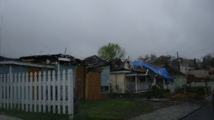
Storm chaser Bob Wade of Wisconsin sends us a couple of pix's of the twister damage to downtown Atlanta and Cabbage Town.


RS

Monday, April 7, 2008

Northeast At Risk, Hurricane Center Chief Warns

Northeast At Risk, Hurricane Center Chief Warns

By NEIL JOHNSON

The Tampa Tribune

Published: April 5, 2008

ORLANDO - The new director of the National Hurricane Center enters his first season seeking better predictions of when storm ferocity spikes and sounding the warning that the Northeast is the country's hurricane soft spot.

Bill Read sat down for an interview with the Tribune as the National Hurricane Conference got under way this week in Orlando.

What part of the country concerns you most as director of the hurricane center?

"New York and New England. They haven't been hit in a long time," Read said.

His reasoning: The area has a large population, is not hurricane savvy and storms reaching that far north are moving forward at up to 50 mph, leaving little time to persuade residents to prepare.

"Someday, they're going to get a repeat performance of 1938," he said.

A hurricane that year roared over New York and New England, surprising residents. An estimated 700 were killed and 63,000 were left homeless.

What factors unique to the Tampa Bay area should we be concerned about?

"It's kind of similar to Galveston. The floodwaters would go far inland," he said.

As in Texas, a storm surge from a major hurricane would push far from the Bay and could turn Pinellas County into two islands.

"You're one of the folks going a long time without a major hurricane," he said.

It has been more than 70 years since a major hurricane scored a direct hit on the Tampa Bay area, longer than New York or New England have gone.

During the 1800s, Read pointed out, a number of storms curved toward the Tampa Bay area rather than hitting to the south or in the Panhandle as they have done in recent years.

What progress is being made to restrict construction in vulnerable areas?

"That's a great question to ask someone in elected office," he said.

Houston, where he had been the meteorologist in charge at the National Weather Service office, has done little, Read said.

Is enough money being spent on equipment and research?

"The short answer is of course not. There is always need for more. That's always a function of budget issues," Read said.

Some years, he said, money goes to personnel or operation of the hurricane center. That money shows results for legislators.

"They can see that money," he said.

Results from money put into research are harder to determine, could be years away or never show up at all. Some research never works out, he said.

If resources are limited, where should they be focused?

"Money for research into intensification is the most important," Read said.

Hurricanes that grow rapidly pose the greatest threat and they are the most difficult to forecast.

Making better forecasts of those changes is a main focus of Read.

Last year's Hurricane Humberto, a short and weak Category 1 that was the only hurricane to hit the country, grew from a depression to a hurricane in less than 24 hours.

Had Humberto made that transition farther from land, it could have caused "heartburn" for people when it hit, Read said.

Three of four Category 3 or larger hurricanes that hit Texas in the last century jumped to major storm status in less than 48 hours.

Better forecasts of this transition lag behind improvements in forecasts of the track, he said.

"Intensity forecasts have shown no improvement."

How can intensity forecasts be improved?

Researchers are compiling what they need to find out about hurricanes when they change intensity in preparation for the launch of a new research project on the subject.

"The background work is being done now. We're still developing a plan for the project," he said.

The problem that the researchers face is that they don't really know what forces are at work to make a hurricane grow quickly from a fairly benign Category 1 to a Category 3 or larger.

So, first, the scientists have to find out why a hurricane goes through such rapid growth before they can put the data into a forecast model and predict when it will happen.

"Until you know what causes these things, you can't make a forecast," Read said.

How far down the line are significant improvements?

"Not soon," Read said.

When the Hurricane Forecast Improvement Project is launched, it could take up to a decade to show the improvements that scientists hope to see.

"In five or 10 years our goal is to reduce the error in intensification forecasts to 50 percent. That's really stretching our goal," Read said.

That rate of improvement would surpass the 2 percent improvement each year that track forecasts have made for the past 15 years.

Reporter Neil Johnson can be reached at (813) 259-7731 or njohnson@tampatrib.com.

WEATHER NOTE

Weather Currents Newsletter - Spring 2008

Spring Climate Outlook

By Tim Halbach, Climate Program Leader

With the snow season mainly done, and a decently cold winter that reminded people of what a typical winter used to be like across the Chicago area, most people are looking forward to the warmer conditions that this Spring and Summer will hopefully be bringing us…if temperatures can ever rise up to normal. With the snowiest meteorological winter (Dec/Jan/Feb) on record for Rockford, and the sixth snowiest meteorological winter in the books for Chicago, does this mean anything for our weather this spring? With La Nina conditions in the Pacific Ocean forecast to last through the spring and summer, does that mean anything for us? These questions and more are answered in the following write up. (Continued)
Experts say faulty storm predictions get too much press

By ROBERT P. KING
Palm Beach Post Staff Writer
Thursday, April 03, 2008

ORLANDO — Is too much Gray clouding hurricane forecasts?

Some storm experts think so. And on Wednesday, they urged the news media to pay less attention to the hurricane season predictions that have made veteran researcher William Gray one of the nation's most prominent weather prognosticators.

The problem, the critics say: Gray's forecasts have been wrong in the past few seasons, predicting too few hurricanes for the record-setting 2005 season and too many storms since.

In addition, they say the hoopla about Gray's number of projected storms obscures the urgent message of preparing for every season - even the quiet ones.

The criticism emerged at the National Hurricane Conference, an annual gathering where Gray is one of the brightest stars and traditionally gives the closing speech.

"I think the seasonal forecasts are a travesty for us to show," meteorologist Jim Cantore, a popular storm chaser for The Weather Channel, said during a morning chat session. "That's something we need to stop doing."

Jim Poling of the Florida News Network agreed: "I really like the idea of not publishing Dr. Gray's forecast. ... I think it's part of the hype."

Bob Breck, a longtime television meteorologist in New Orleans, even argued that Gray's predictions bite homeowners with higher insurance premiums.

"The insurance companies are using these numbers to keep our rates high," Breck said.

Gray shrugged off the brickbats, saying he's used to receiving "hate mail" for his work. He attributes much of it to the past two quiet seasons.

"Wait till we have an active season - then they'll change their minds," said Gray, a Colorado State University researcher whose next forecast comes out Tuesday.

His predictions draw on clues such as ocean temperatures and global air currents. After each season, Gray and his team publish an analysis of where they went wrong.

"I'm amazed what I've learned over 25 years," he said.

Gray's defenders include former National Hurricane Center Director Neil Frank, who said the forecasts have performed well in predicting whether a season will be calmer or busier than average.

"He's been very, very good," said Frank, who led the center from 1974 to 1987. "But it's a forecast, which means you're going to have some errors."

Bill Read, the new director, declined to comment on Gray's work. But he said the center's parent agency will seek less publicity than usual when it issues its own hurricane-season forecast later this spring.

Read urged the media to push a different message: "It only takes one storm to ruin your day."

Tornado safety tips for wherever you are

Star-Telegram staff writer

For residents new to Texas, it's time to formulate a severe weather plan -- particularly for tornadoes.

For you natives, just get the old plan ready.

With spring comes the potential for severe weather, and area emergency management coordinators are urging residents to be prepared for the hail, heavy rain and tornadoes that could accompany storms.

And there will be storms. North Texas is in tornado alley, an area known as an incubator for devastating tornadoes.

Some area residents have built storm shelters and "safe" rooms as a means to survive Mother Nature's wrath, but if you don't have such a place to go, there are still steps you can take, according to the American Red Cross and area emergency management coordinators. The procedures include:

If you are in a vehicle, get out immediately. Take shelter in a sturdy building. If there is no building, go to a low-lying area until the storm passes. Officials do not recommend taking cover under bridges and overpasses.

"You should never try to outrun tornadoes if you're in a vehicle," said Perry Bynum, emergency management coordinator in Haltom City. "So many times last year, I saw videos of tornadoes in the area and there were cars and trunks driving around."

On April 13, a tornado hit Haltom City, killing a man and causing about $1 million in damage.

If you are in a high-rise building: Pick a place in a hallway in the center of the building. Center hallways are often structurally the most reinforced part of the building.

If you live in a mobile home: Choose a safe place in a nearby sturdy building. Mobile homes are much more vulnerable to strong winds.

Pick a safe place in your home where family members can gather. The safest place is underground and away from all windows, but many North Texas houses do not have basements. An interior hallway or a room on the lowest floor is the best choice. Officials say putting as many walls as you can between you and the outside wall will help.

"Most injuries from tornadoes and high-wind storms are caused by glass and flying debris," said Anita Foster, a spokeswoman for the American Red Cross in Fort Worth. "You want to look for the most interior part of your home without any windows."

Officials encourage families to have 72-hour preparedness kits in their homes. The kits should include keys, cash, first-aid supplies, can openers, food that won't spoil, candles, matches, water, flashlights and batteries.

"It would also be important to have a portable radio so you can hear the weather reports," said Sean Hughes, North Richland Hills' emergency management coordinator.

Check with your workplace and your children's schools and day-care centers. Learn about their tornado emergency plans. Every building has different safe places. It is important to know where they are and how to get there in an emergency.

Discuss tornadoes with your family. Everyone should know what to do, in case all family members are not together. Officials say that discussing disaster plans reduces fear and helps everyone know how to respond.

"The best time to make a tornado plan is while the sky is blue," Foster said. "Once it's green and rotating, it's just too late."

Texas tornadoes

Each year, Texas is among the states with the most tornadoes, and forecasters believe that 2008 will be no different. Here are the most recent statistics for the state:

1996: 138

1997: 191

1998: 123

1999: 179

2000: 147

2001: 137

2002: 173

2003: 155

2004: 179

2005: 105

Source: National Climatic Data Center

ramirez@star-telegram.com
DOMINGO RAMIREZ JR., 817-685-3822


MARITIME NOTE


Saturday, April 5, 2008 8:13 AM PDT

The Karlissa A and Karlissa B are being prepped like prize fighters.

Titan Maritime’s two jack-up barges, which will serve as the work platforms for the removal of the shipwreck of the New Carissa, arrived from the Dominican Republic last Saturday. They have four to six weeks to work up the challenge. Round one is scheduled to start May 15.

Phil Reed, Titan’s director of engineering, hopes gloves will touch a bit sooner. His goal is to have the imposing barges with their gargantuan cranes and beach staging site ready by May 1.

All that will be left then will be the wait for good weather. Reed said Titan needs calm seas to take the barges out to the New Carissa stern, preferably swells of no more than 3 feet. The barges, once ready, will be docked at Sause Brothers Ocean Towing Facility in Empire to wait for perfect conditions.

“We are not going out there unless it’s a really nice day,” Reed said.

It wasn’t a nice day on Feb. 4, 1999, when the wood chip ship ran aground.

Nine years later, Titan gets to clean up the remains. The May 1 start date may be a little ambitious, considering how much work remains to be done.

The huge steel tubes out at Central Dock in Coos Bay are the legs of the barges. The giant tubes, each originally 150 feet long, were cut up for transport into three pieces — two 60-foot-long pieces and one 30 feet long. Crews will weld the two bigger pieces together to provide the needed height for the project. Each leg will be jammed 30 feet into the sand to stabilize the barges near the wreck. Putting the legs back together again is the biggest project on Titan’s to-do list in the next couple of weeks.

The Karlissa B’s 300-ton-capacity crane, nicknamed “Big Red,” is in the process of being repaired and repainted before installation on the barge. The other towering red crane at the dock next to the two barges will be placed on the Karlissa A.

Titan is using local businesses and resources for the prep work.

West Coast Contractors of Coos Bay helped put together the crane at Central Dock. Reed said Titan enlisted that crew to do more work on the barges.

“I’m just glad to be working at home right now,” Karlissa B crew member Jason Snelgrove said Thursday.

Snelgrove was working in Newport when the New Carissa’s bow ran aground near Waldport in March 1999, after the towline snapped as it was being pulled out to sea. He hasn’t been out to see the stubborn stern section yet, but may have the opportunity while working with Titan on the removal.

“However long they will have us, we will stay with them,” Snelgrove said.

Knutson Diesel and Machine is fabricating the 31-foot-tall tower that will connect the barges to the beach staging site, approximately 1,000 feet away from the New Carissa. The tower connection will be via an overhead cable car line. Crews and equipment will travel back and forth from the barges in the 6-ton-capacity car.

The staging area construction won’t begin until near the end of this month, after the last of the required temporary permits are issued. The staging area will include a temporary bypass road around the work area to allow alternate access to the North Spit.

Once work starts, the New Carissa will be taken apart a little bit at a time.

Deconstruction

Titan crews will cut up the vessel’s stern and remove the pieces using the cranes. Cutters will detach most of each piece of metal, but leave a 6- to 8-inch piece called a hanger so the cut can be secured to the crane. Once the pieces are rigged to the crane, the hanger will be cut and the metal transferred to one of the barges. Each piece will then be “flat packed,” cut to a size and shape that is easier to store on the deck. Reed said Titan intends to cut, process and store all the scrap metal on the barges until the job is done.

Crews will start working on the top of the wreck. Reed said that will be the easy part and may give onlookers the impression the job will be done fairly quickly.

“In the first couple of weeks, you will see a big difference,” he said. “The steel on top will be easy.”

Dealing with what is underneath, including the 250-ton main engine, will present the real challenge and take the most time. Still, Reed anticipates the work will be done well before the October deadline.

As crews work on the top portion, six pulling machines connected to the New Carissa by bulky anchor chains will pull on the wreck. Reed said the New Carissa may move right away under the pulling power or stay put until some of its bulk is hauled off. Pullers will progressively lift the New Carissa out of the sand.

“We are actually going to bring the bottom to us, rather than go down and work in conditions that are near impossible to work with,” Reed said.

Titan’s contract with the state stipulates crews can leave the portion under the sand line, but Reed said Titan is aiming at leaving no portion behind.

“For us, that is harder,” Reed said “We would rather follow the plan.”

To slice the wreck off at the sand line, a diver would have to cut while in the surf, a process which can be dangerous and inefficient, Reed said. The movement of the surf will prevent an even cut and divers could possibly be injured in the process.

A summer work window was chosen because of the favorable weather, but if nasty weather strikes, crews shouldn’t be stalled completely. The barges should be secure, no matter what is thrown at them, Reed said. Strong winds could shut down the cranes and possibly the overhead cable car.

If wind does prevent use of the cranes, workers can work on cutting the scrap pieces to storable sizes or work on removing sand from the wreck.

“We won’t be completely shut down unless things get really bad,” he said.

Though the Titan’s plan includes being as weather-independent as possible, the New Carissa’s location does present unique challenges.

Reed, who has worked with Titan since 1993, first as a consultant and, since 2000, as a full-time project engineer, said he hasn’t worked in these particular conditions.

“This is first time I’ve been in such an active surf zone,” he said.

Titan has been following the attempts to haul off the New Carissa from when it first ran aground. He thinks using the stable jack-up barges may be the answer to the stuck stern. Titan crews have had experience with large wrecks and have worked in surf zones, but the question remains as to how quickly crews can work with both challenges.

“We’ve cut up wrecks bigger than this,” Reed said. “But not one sitting in the surf zone.”

RS

Friday, April 4, 2008

Lake freighters get going despite ice

Lake freighters get going despite ice

By Joe Knaapen

Gannett Wisconsin Media
March 26, 2008

STURGEON BAY -- The winter fleet at Bay Shipbuilding Co. has begun the annual spring migration to the Soo Locks.

Four freighters — the 1,000-footers Paul R. Tregurtha and Edgar B. Speer, and the 767-foot Arthur M. Anderson and the 806-foot Charles M. Beeghly — left Sturgeon Bay Sunday in the race to be first through the locks at Sault Ste. Marie.

The freighters ran into heavy ice on Green Bay, and were delayed despite tracks cut by the Coast Guard cutter Mackinaw and maintained by the cutter Mobile Bay and commercial tugs.

The freighters coming out of Bay Ship lost the race to the Cason J. Calloway, which sailed out of Erie, Pa., and was first through the Soo.

“There’s plate ice out there a couple of feet thick,” said Lt. Cdr. Matt Smith, commander of the Mobile Bay, which makes its home port in Sturgeon Bay.

After the Mackinaw cut a track south to Sturgeon Bay and returned back north to the Soo, Smith said the Mobile Bay was assigned to keep the path open for commercial traffic. Temperatures turned cold over the weekend, however, bringing ice back into the cut.

While the commercial tug Erica Kobasic out of Escanaba handled close escort work, the Mobile Bay widened the track north from the Sherwood Point light at the mouth of Sturgeon Bay to the Rock Island Passage, which connects Green Bay to Lake Michigan between Rock Island and Michigan’s Garden Peninsula.

Starting Tuesday, the Mobile Bay began cutting a track from Sherwood Point south to Green Bay, opening its port to ship traffic, Smith said.

The opening of the Soo Locks each spring begins the commercial shipping season on the Great Lakes.

The locks and St. Mary’s River provide a link between Lake Superior — where iron ore mined in Minnesota is stockpiled at shore ports — and the lower lakes, where mills that use the raw material line the shores from southeastern Wisconsin to upstate New York.

Traditionally, according to the U.S. Army Corps of Engineers, which operates the locks, more than 4,000 vessels carry up to 90 million tons of cargo through the locks every year. Most vessels transport iron ore; others carry coal, grain or stone.

North of the Soo, the Mackinaw has laid out tracks in ice 2-4 feet thick since March 14, said Lt. Cdr. John Little, who commands the Coast Guard’s largest and newest ice-breaker.

The 240-foot Mackinaw cut paths north from the locks to Whitefish Point, where freighters can find open water heading toward Minnesota ports such as Duluth, Taconite Harbor and Twin Harbors.

The Mackinaw escorted the through the locks early March 25, and ready for the next two northbound freighters and the southbound 1,000-foot Edwin Gott, which was downbound from Twin Harbors, Minn., with taconite for Gary, Ind.

The season has been Mackinaw’s busiest, said Little, who commanded Mobile Bay out of Sturgeon Bay a few years ago.

So far this month, the Mackinaw, which was commissioned in 2006, has served as host to Coast Guard Commandant Adm. Thad Allan and a crew from the Weather Channel.

At Bay Ship, the ship movement means the crew of about 700 workers are under pressure to put the finishing touches on myriad details needed to put the winter fleet — 18 ships this season — back to work.

Nine freighters remain in port and most are expected to be gone by the end of March.

The phrase “winter fleet” applies to all the ships — from ferry boats to superfreighters — that make Bay Ship their home for the winter for repairs, inspections, surveys or offseason docking.

“We had a lot of late arrivals, boats coming in in mid-March,” said Todd Thayse, who manages repair services at Bay Ship.

By the end of the week, he added, all but three ships will have cleared the yard in Sturgeon Bay.

“There was heavy cargo demand, so they stayed out for an additional trip,” Thayse said of the ore carriers. “The steel industry is strong, so the demand is there for them to get back out there.”

Since mid-January, Bay Ship has worked three shift, seven days a week to get the repairs completed on time for captains and owners who are anxious to resume moving cargo, Thayse said.

“Everybody is trying to get out,” Thayse said. “They have to be careful because there’s heavy plate ice out there. The winds can move the plates, and take the ships right along with it.”

Demand was so heavy, Thayse said, that three freighters — the 1,000-footers Burns Harbor and Stewart J. Cort and 728-foot Joe Block — wintering in Milwaukee under the Bay Ship umbrella left earlier this month to haul taconite out of Escanaba.

Heavy ice conditions on Green Bay are helping convince some captains to use the ship canal and go east out of Bay Ship through Sturgeon Bay to Lake Michigan, Thayse said.

The captains are weighing the time savings and risks of traveling on low water through two downtown bridges and the Bayview Bridge over State 42-57 compared with potential delays in heavy ice by going west to Green Bay and north to Rock Island.

WEATHER NOTE

Investigating Weather Systems in the Montessori Classroom

North Carolina is in a severe drought. Currently, we are short approximately 10.5 inches of rain for the past two years. Severe water restrictions are in effect and hearing that neighboring towns have less than 100 days of water left is a frequent occurrence. That being said, we are entering our rainy spring season which also brings months of tornado warnings. Naturally curious, children want to know what causes weather, especially severe weather.

The Montessori classroom is a great place for children to learn, explore, and research naturally occurring phenomenon such as thunderstorms, hurricanes, and tornados. These concepts are usually introduced during the upper elementary years. Here, in North Carolina, we experience both hurricanes and tornados and this is enough to spur discussion and interest. If you live someplace where these weather systems do not occur, you can peak student interest by announcing that there are approximately 40,000 thunderstorms around the globe each day and that the class will have an opportunity to investigate how thunderstorms, hurricanes, and tornados form.

Before presenting these lessons to the children, it is important to have illustrative charts made of sea and land breezes, cold fronts, and warm fronts, as well as a map of high and low pressure systems and a variety of photographs (or video) of thunderstorms, hurricanes, and tornados. There is also a variety of vocabulary that needs to be explained before children can begin their investigations.

  • Sea breeze
  • Land breeze
  • Cold front
  • Warm front
  • High pressure system
  • Low pressure system
  • Convection
  • Coriolis effect

It may be helpful to watch the weather reports together over a period of several days in order to discuss and understand the terminology. You might also gather the weather report over a period of about two weeks and make predictions as a class as to what weather will be developing.

For more information for teachers, visit the National Hurricane Center website.

For informative, interactive games for students, visit Federal Emergency Management Agency website.

NAMC’s Upper Elementary Physical Geography curriculum manual provides background information and presentations on many weather related topics, including: Weather Systems and Weather Maps, Investigating Hurricanes and Thunderstorms, and Investigating Cold and Warm Fronts.


Tornado preparation key in central Illinois

With twister season under way, being ready for disaster is vital

Wednesday, April 2, 2008

Peoria - When it comes to natural disasters, preparation is of the utmost importance.

With that in mind, the American Red Cross is urging people to take steps today to prepare for the tornadoes of tomorrow.

Tornado season officially began Tuesday, and will run through the end of June. And while central Illinois lies on the outskirts of the infamous Tornado Alley, the area is certainly no stranger to twisters.

Of the 15 counties in Illinois that have seen the most tornadoes since 1950, Tazewell and Woodford counties rank fifth and seventh, respectively. Then take into account that Illinois is annually one of the most affected states by twisters - 41 per year - and early precaution seems like a no-brainer.

"It is incredibly important," American Red Cross Central Illinois Chapter communications director Vickie Parry said. "The threat is very real, probably one of the more real threats of disasters we have in central Illinois. They can happen at anytime."

Which makes preparation all the more important, said Mike Hardiman, a meteorologist at the National Weather Service in Lincoln. He said since tornadoes are typically not easy to forecast on a long-term scale, people should always be cautious of severe weather possibilities.

"Absolutely it makes it important for preparation, because we don't necessarily have the means to know when tornadoes can happen," Hardiman said. "But one could say that since we had an active winter, we could have an active spring."

Just the thought of a spring more active than Peoria's winter ought to prompt action.

"We can't prevent them, but we can certainly help people be more prepared so they can be more safe," Parry said.

Parry said traditional tips such as seeking shelter in a basement or a low-lying area are always relevant, but smaller details are just as vital.

Making sure children know what county they live in and how to locate it on a map can make a big difference as tornado warnings and watches are typically issued on a county-by-county basis. Also knowing the difference between a tornado warning and watch is valuable. A watch is when the threat of a tornado exists while a warning means a tornado has already touched ground.

"What we find is that kids, especially if they are watching TV, know they live in Peoria or Morton or wherever," Parry said. "But they may not know what county they live in, and that is important. If people can just take a few minutes to talk with their families on what to do in case of an emergency, it can go a long way."

Brian Feldt can be reached at 686-3194 or bfeldt@pjstar.com.

MARITIME NOTE

Salvager tells of Napoli operation

OTTERY Rotarians had an insight into the salvage of the MSC Napoli thanks to a visit from a salvage expert working on the job.

Kees Van Essen, the senior salvage manager from Dutch company SMIT, arrived at the Tumbling Weir Hotel this week to give a detailed view of the company's work on the stricken ship.

The hastily convened meeting covered the whole incident from the ship's grounding, in Janaury 2007, when high seas caused it to lose containers off the coast at Branscombe.

It also covered its unloading and subsequent removal.

Otter Valley Rotarian Chris Pink said: "It was a real coup for Ottery to have him come from Holland and speak.

"I sent him an e-mail and he said maybe but, as he was so busy, he could not commit."

Mr Pink said he then received a surprise phone call last week to say SMIT would cover the expenses and Mr Essen would be available on Tuesday evening."

Mr Pink said: "It was a fascinating evening and Rotarians from across the area came to hear him detail the whole picture from start to finish.

"It gave a real insight into the difficulties they faced as storms continued to damage containers throughout the operation.

"He had a massive amount of experience from previous incidents such as the Sea Empress."

Mr Pink managed to secure Mr Van Essen through his own contacts in the shipping industry.

Prior to retirement he was the secretary of the International Maritime Organisation, the United Nations' specialised agency responsible for improving maritime safety and preventing pollution from ships.

The talk was part of a programme of events to increase membership of the Otter Valley Rotary Club.


Enjoy your weekend!

RS

Thursday, April 3, 2008

Board Investigates Alaska Ranger

Board Investigates Alaska Ranger

DUTCH HARBOR, Alaska - The Marine Board of Investigation into the Alaska Ranger casualty began Monday's session by taking testimony from Capt. Craig Lloyd, Commanding Officer of the Coast Guard Cutter Munro.

According to Lloyd's testimony the Munro received the Alaska Ranger's mayday at 2:52 a.m.

Munro immediately made best speed to the Alaska Ranger's position, using their turbine engines, which propels the ship faster than the diesel engines. At 5:55 a.m. the Munro launched their helicopter. They were about 50 miles away.

Due to the stops they had to make to accommodate helicopter operations they did not reach the scene before the helicopters and the Alaska Warrior picked up the crew of the Alaska Ranger.

The MH-60 Jayhawk helicopter was unable to lower the survivors they had on board to the Alaska Warrior due to icy decks and rigging in the way of the basket.

The helicopter radioed at 6:12 a.m. to the Munro that they were en route with survivors that needed emergency medical care.

At 6:44 the helicopter crew began lowering survivors. Of the 12 survivors onboard the helicopter nine were ambulatory and three were non-ambulatory. As the 12th member was lowered the helicopter crew passed that that was the last survivor on board.

The MH-60 helicopter began to conduct in-flight refueling (HIFR). Usually this operation takes 15 minutes and the ship stays at minimal speed.

The Munro broke off the HIFR with the MH-60 in order to dash to rendezvous with the HH-65 helicopter, which was fuel critical. The HH-65 landed on board with five survivors and 18 minutes of fuel left until splash down. The MH-60 later returned with four more crewmembers onboard.

A total of 21 crewmembers were delivered to the Munro. One man was non-responsive; he was immediately taken to sickbay where the medical crewmen conducted CPR and intubated the crewman. CPR efforts continued for 45 minutes before the flight surgeon directed them to cease efforts.

The Munro departed at 11:00 a.m. when it appeared all Alaska Ranger crewmembers were accounted for. At 12:35 p.m. Coast Guard District 17 North Pacific Rescue Coordination Center notified the Munro that one crewman still missing. The Munro returned to the scene and resumed search operations.

Lloyd said the discrepancy in numbers was noted during the flight operations but the crew was more focused on getting the helicopter refueled and back to the scene to rescue more crew.

The Munro conducted drug and alcohol testing on the helicopter crew as directed by District 17 NPRCC.

During the search for the missing crewman, Satoshi Konno, Lloyd said, "We saw a lot of debris. The MH-60 swimmer was lowered into the life rafts to check for survivors."

The lawyers for the Fishing Company of Alaska did question Lloyd for clarification on operations and the timeline of events.

Evan Holmes, of Neosho, Missouri, was next to testify. He was the factory manager on the Alaska Ranger and had worked on board the Alaska Ranger for about two years. He was a shift leader and became the factory manager on the previous underway tri. Holmes worked a 12 hours on six hours off schedule.

According to Holmes it was about 2 a.m. and he had gone to the galley to watch a movie. The telephone began to ring in the galley. "I thought someone was playing with the phone," he said. Then phone in the kitchen portion of the galley was ringing too.

Holmes ran up to the bridge to see if something was going on but before he reached it David Silveira told them they were taking on water in the ramp room.

Holmes and Chris Cossich, both members of the emergency squad, made their way to the ramp room on the port side through the factory and the harbor generator room. They saw a foot to a foot and a half of water in the ramp room.

"We didn't have our boots on," said Holmes. Holmes had on tennis shoes and Cossich was wearing flip-flops. They did not want to go through the water to the portable dewatering pump next to the bench in the shop, but decided to in order to get the pump. Holmes, Cossich, Indio Sol and another crewman began setting up the pump.

Before they fired up the pump the crew was directed to the wheelhouse to don survival suits by the Assistant Engineer Lundy. Holmes put the hose back inside the door, but left the watertight door open because more crewmen were coming up the stairs behind him. Holmes went through the house to make sure no crewmembers were still in any staterooms.

In the wheelhouse he donned his survival suit and heard the mayday call being made by Silveira, the Mate. Holmes confirmed what other crewmen have said that after donning their suits they rotated through the wheelhouse to stay warm until they abandoned ship.

Holmes said they took a roll call to make sure everyone was accounted for. He also stated the stern was sitting lower. A wave came over the stern and washed the nets into the sea. After the wave came over the stern the ship took an "unnatural shake to it and a hard list to starboard," said Holmes. He said the vessel stayed rolled over to starboard.

"You got your normal rolls in the ocean, but it felt like a rogue wave that hit real hard and it shook," said Holmes.

Once the ship rolled the crew was directed by the Captain to launch the rafts. Holmes saw two of the rafts inflate in the water. They were tied to the rail, but one broke away.

Holmes said he was probably the fifth man in the water. He held onto the line to his raft at first, but waves began to pull him under so he let go. "It was so strong pulling underneath," said Holmes. "So it was let go or drown right there."

He and two other crewmen hooked up to form a chain. A helicopter rescued all three; the helicopter crew tried to lower him to the Alaska Warrior, but decided it was too risky and delivered Holmes and the other crewmen to the Coast Guard Cutter Munro.

The board asked for more clarification on the factory operations, shipboard operations and the role of the Japanese fish master. When asked what the role of the fish master was Holmes replied, "Find the fish!" The fish master also made sure the nets were set correctly and occasionally observed the factory operations.

When asked about the drug and alcohol policy Holmes said the company has a no tolerance policy. He also confirmed that a crewman had been let go at the end of the previous voyage for coming back to the boat smelling of alcohol and being obnoxious. He never observed anyone drinking at sea.

The lawyers for the company asked a few clarifying questions before Holmes was released.

Following Holmes testimony the Board called Gwen Raines, one of two National Marine Fisheries Observers who were the Alaska Ranger.

Raines made one short voyage to the Pribilof Islands before returning to Dutch Harbor. She remarked that the fishing was unremarkable, but that there was a lot of ice around. She had just come from fishing in the ice so it didn't strike her as odd.

After returning to Dutch harbor to offload fish and change nets, the Alaska Ranger left on the fateful voyage. Raines stated that the vessel had a port list at departure. She said the crew indicated the full fuel tanks tended to give the ship a port list. They explained to her that after some of the fuel was used up the vessel would even out. She said the list and steaming in the trough of the waves made for a miserable ride.

Raines was asleep in her rack when the phone rang. She answered and there was no one on the line so she proceeded to the wheelhouse to see if they had been trying to reach her. When she reached the wheelhouse Silveira said, "This is bad - really, really bad." She heard Rodney Lundy, the Assistant Engineer, telling Silveira that there was water in the rudder room.

She saw Lundy and the emergency crew go below to partition off the areas that had flooding to save the ship. She said the Chief Engineer, Daniel Cook, wanted to prevent it from reaching the engine room. Raines said the crew was gone at least 30 minutes. She became concerned about the duration they were gone.

Meanwhile on the bridge, Silveira was communicating to the Alaska Warrior and made the mayday call to the Coast Guard. He kept a five-minute communications schedule with the Coast Guard.

The engines started to sputter and the lights flickered. Shortly after that Silveira stated he had lost steering and the vessel was moving astern.

Raines had put on her survival suit and Lundy activated her emergency position radio-indicating beacon on the wrist of her suit. She had Lundy activate it because the gloves on survival suit did not allow her to do so herself.

She said she went to her raft assignment and when it was launched they couldn't see if it deployed. She called back to Silveira. He started to come out of the wheelhouse to assess the situation and the painter line to the raft parted.

On the other side the painter was still connected to the raft, but it was a long way down. She saw one man climb down. She attempted to do the same, but fell into the water. Once in the water she found the painter and pulled herself to the life raft. She said two of the Japanese technicians pulled her in. She did not watch the ship go down, but did listen to the conversations of others. They said the vessel sank in about 15 minutes.

Raines was asked about the condition of the vessel. She recalled a laundry list of safety items that she has to inspect to determine if she should sail on a vessel. She said several items on the list must be correct or she is not allowed to get underway on the vessel. There are also discretionary items. She was concerned with two items, but decided to remain on board and report the items later.

When asked about drills she said only one was conducted while she was onboard. It took place at 2 a.m. and consisted of the crew mustering and describing where they would be and what their duties were in such a situation. Raines said they never discussed abandon ship procedures.

The board inspected the survival suits from the Alaska Ranger's crew at the Dutch Harbor fire station today. Some minor damages were noted.

The board will reconvene Tuesday at 9 a.m. and will hear testimony from two of the Japanese crew with the assistance of an interpreter.

MARITIME NOTES

Disaster Response

When G.A.P. Adventures learned its signature cruise ship was sinking off Antarctica last fall, its crisis management team kicked into action.

David Pett, Financial Post Business
Published: Tuesday, April 01, 2008


When Bruce Poon Tip's phone rang in the dying hours of Nov. 22, 2007, the founder and CEO of Toronto-based G.A.P. Adventures Inc. wasn't too concerned. Jeff Russill, the travel outfitter's director of product and operations, was on the line from his home in Toronto. Russill explained that Richard Heller, the company's expeditions coordinator, had just received a call from the Swedish-based tactical team for the company's prized cruise ship, the Merchant Vessel Explorer. It had hit an unidentified object, assumed to be ice, just south of the South Shetland Islands off Antarctica.

The Explorer, Russill noted, was stable and the crew was busy assessing the damage. All 154 people on board, meanwhile, were safe. "Jeff told me it was a manageable situation and I wasn't too worried about it, so I went back to bed," 41-year-old Poon Tip recalls. But less than half an hour later, the phone rang again. This time, Poon Tip was expecting the worst.

Russill explained that the ship had a hole torn in its hull, and water was accumulating in the lower deck. Captain Bengt Wiman had given the mayday signal and rescue ships were headed towards the scene. The bilge pumps were removing water and passengers were gathering in the muster room on the top deck.

Russill told Poon Tip that they needed to assemble G.A.P.'s critical incident management (CIM) team, a group of staff who had been selected in advance to handle a potential crisis. Poon Tip rattled off the names of the CIM members he thought they would need, and Russill quickly phoned them. Within the hour, they had gathered at the company's offices in downtown Toronto. When Poon Tip entered the makeshift "war room," a third floor back office, the rest of the team, consisting of Russill, Heller and Frank Schuran, vice-president of product and operations, gave him more details on the situation.

For Poon Tip, the business he had built from the ground up was now precariously adrift in icy waters half a world away. A ship was sinking, lives were on the line and Poon Tip and his colleagues knew that how they handled the situation would determine the passengers' fate and the fate of their company. In the hours that followed, they would struggle to make decisions and stay on top of the far-flung events as the Explorer was evacuated, passengers were rescued and the ship sank. In the weeks that followed, G.A.P.'s management would deal with the incident's aftermath, trying to make peace with clients and insurers and rebuild their business. The events - and G.A.P.'s handling of them - provide lessons to other companies that could potentially face crises of their own.

Poon had spent 17 years building G.A.P., which he started in a Toronto garage. Since then, the company had grown into the world's largest adventure travel outfitter, with annual sales of $120 million. It was considered the best by various industry experts, including National Geographic Adventure magazine, which rated the company the top "do it all" outfitter on the planet last fall.

A large part of G.A.P.'s success was due to its 2004 purchase of the MV Explorer. The iconic boat, known as the "little red ship" for its brightly painted hull, was the first cruise ship specifically designed to sail the waters off Antarctica. Since its initial expeditionary cruise in the South Pole region in 1969, it has become one of the most well-travelled cruise ships in history. Buying the Explorer helped legitimize G.A.P. Adventures, moving the company from a simple "backpackers" travel agency, to a big time adventure outfitter famous the world over for its polar expeditions.

With more than 1,000 tours worldwide and 70,000 customers a year, Poon Tip knew the company was likely to run into emergency situations from time to time. Over the past few years, efforts were made to develop the company's emergency response process. At the heart of the plan is the critical incident management team. When a potential emergency situation arises, each one of G.A.P. Adventures' department heads is authorized to call a CIM meeting to order. In the past year, meetings were called to co-ordinate tasks following the Peru earthquake and the outbreak of civil unrest in Kenya. In less severe cases, a simple e-mail to team members has sufficed. The end result can be as simple as posting a travel advisory on the G.A.P. website, or it can involve a trip cancellation or passenger evacuation. The Explorer incident, however, would put the company's CIM team to the test.

After the team arrived, the war room, with its brick walls and exposed duct-strewn ceilings, quickly filled with energy. Laptops hummed, phones beeped and voices crackled over the speakerphone the group was using to communicate with the ship's tactical team in Sweden, which was relaying information to G.A.P.'s Toronto office from the boat's crew. They all hoped they wouldn't need to rely on rescue ships for assistance, and planned to patch the Explorer's hull and return the ship to Ushuaia, Argentina, where the cruise had departed from 12 days earlier.

As voices on the speakerphone continually updated the team on the ship's status and safety of passengers, Heller, with assistance from the others, completed his predetermined task of phoning embassies, insurers and the search and rescue centre for the region. The team members also notified the nearest oil pollution response centre in Punta Arenas, Chile, and the agencies that employed the ship's crew.

The CIM team simultaneously updated the voice mail message and website with information on the situation, and set up phone hotlines to handle calls from passengers' family, friends and travel agents. As the night turned to day, G.A.P.'s customer service representatives began phoning passengers' emergency contacts.

The war room was a high-stress environment, made worse by the fact that the CIM team was so far from the scene of the incident. It was frustrating because it was difficult for them to gauge just how things were progressing.

After more than an hour in the war room, the team received distressing news from their Swedish colleagues: The ship's bilge pumps were overwhelmed and the engine rooms had flooded, causing the boat to lose power. The Explorer was now listing noticeably and drifting towards another sizable ice patch. Knowing the closer it got to the ice, the harder it would be to offload passengers safely, Captain Wiman decided to get passengers and the majority of the crew in lifeboats. Most of the crew would divert their energies from saving the ship to executing the evacuation.

The captain and selected crew remained onboard in a last gasp effort to save the vessel. Instead, the listing worsened, and after a couple of hours, Captain Wiman made the final call to abandon ship. Some 15 hours later, the MV Explorer sank to the bottom of the ocean. "It was a big decision to abandon ship," Poon Tip says. "Up to that point, many of us were sure it could be saved. But ultimately, the concern is for the passengers. When you've exhausted all options and it becomes unsafe, you have to do what's prudent to save the passengers, as opposed to what's financially prudent - saving the ship."

Although it was second nature for Poon Tip to call the shots, he knew it was best to follow protocol and allow his team to do their jobs. But Poon Tip still had to show he was in charge. Some staff coming into the building for their regular shifts were in tears; others were curled up on the floor, crying. He fired off an e-mail to staff to commend them for their handling of the crisis so far and urged them to keep working together. "This was a very emotional and devastating thing to happen and people were relying on me for energy at the lowest points," he says. "There were times when I felt like it could fall apart, with the emotions that were going through everybody, especially in the war room."

With passengers now crammed in lifeboats, battling swells of up to two metres, the CIM team turned its focus to the potential rescue vessels, which were still more than four hours away. Although it wasn't the closest boat to the Explorer, the CIM team agreed that the Norwegian cruise ship MS Nordnorge was the ideal ship to handle the rescue. Poon Tip got on the phone and started negotiating with the ship's owner. With some 200 empty cabins, the Nordnorge could accommodate all of the Explorer's passengers comfortably. The ship also had medical services and plenty of food and drink - including a well-stocked bar that many stressed passengers would later take full advantage of.

By 3 a.m. ET, the Explorer was an international news story, headlining morning programs in Europe. In fact, even before the CIM team was assembled, members were being called on their cellphones by reporters eager for a scoop. By dawn in Toronto, most news outlets around the world had mentioned the incident.

Conspicuously absent at the war room table in the early hours of the crisis was Susan Hayes, G.A.P.'s vice-president of marketing. She wasn't notified until close to 3:30 a.m. "It was one of the worst decisions I made," Poon Tip says. Until Hayes was woken up, the rest of the CIM team had to answer the media barrage themselves, adding undue stress to an already tense situation.

"From the time I woke up, I did my first phone interview live on the BBC about five minutes after," Hayes says. "I was undressed for four hours and couldn't get in my car to go to the office. My cellphone voice mail was full, my home voice mail was full and every time I tried to place an outgoing call, an incoming call came in. It was just non-stop from the moment I woke up."

Despite only talking briefly with her colleagues, Hayes was able to accurately inform the media of the passengers' status and provide names and countries of origin. Hayes quickly took the tone with the media that G.A.P. was in control of the situation.

For days, outside scrutiny was relentless. Poon Tip recalls journalists staking out his home and making unwanted phone calls to family and friends. They even followed him to his local gym and waited as he worked out on the treadmill. At times, journalists' lines of questioning were extremely antagonistic. "It was like everyone was out to get us," Hayes says. Case in point was an early story regarding a May 2007 ship inspection that uncovered safety deficiencies, such as problems with watertight doors, improperly maintained lifeboats and missing search and rescue plans. Hayes was quick to set the record straight, pointing out that the deficiencies had been dealt with and the boat had been cleared for sailing by the appropriate authorities.


The passengers drifted for five hours before the Nordnorge arrived on the scene and lifted the evacuees on board. Although everyone was safe, it was hardly the end of the story for G.A.P. - the company's handling of events after the rescue would become fodder for Internet chatter and customer complaints that would occupy the staff for weeks to come.

Passengers travelled on the Nordnorge to international research stations on King George Island, where passengers washed up, ate and got some much needed sleep. G.A.P. had arranged for the Chilean Air Force to airlift passengers to Punta Arenas, Chile over the next couple of days.

In Punta Arenas, G.A.P. Adventures officials gave each passenger a US$200 voucher for a department store that had opened during off hours at the request of the Chilean government. Having lost everything but the clothes on their backs, passengers Rob and Cheryl Beck say the shopping excursion was a welcome treat after such a horrible ordeal. "To get clean clothes and regular shoes on our feet, it made us feel human again," says Cheryl.

Up to this juncture in the crisis, the couple from Edmonton was generally thankful for the rescue effort. Despite the lingering concerns about the evacuation, including overcrowding and broken engines on many of the lifeboats, the Becks never doubted the sincerity and hard work that G.A.P. put in to secure their safety. Unfortunately, for them and many other passengers, the goodwill towards the company began to chip away in Punta Arenas.

To start, the couple says counselling services were never offered. They also complain that efforts to reschedule flights home were complicated because G.A.P. representatives on the scene had no financial authority to book seats that weren't in economy class. The biggest grievance, however, revolves around the compensation G.A.P. originally provided to passengers. Each passenger was mailed a cheque for US$9,300 as reimbursement for the cost of the trip and personal belongings lost with the ship. In the Becks' case, the compensation didn't come close to covering the full cost of the trip, despite alleged promises back in Punta Arenas that a full refund would be forthcoming. After complaining, the couple ended up getting close to a full refund, but both Rob and Cheryl remain bitter. To this date, they say G.A.P. has not adequately apologized for the ordeal they were put through.

In response, Susan Hayes says counselling was offered, although she admits some passengers may not have been informed about the service. As for the flights home and refunds, Hayes says G.A.P. officials had arguments with the insurers on how the passengers should be compensated, but ultimately were forced to defer to their insurance company. "Once the boat sank, a lot of decision-making abilities were stripped from us by the insurance company, and we struggled with that," says Hayes. "Had we been in charge, we would have handled things differently."

In February, three months after the sinking of the Explorer, a sombre mood lingers in G.A.P.'s Toronto office. Even though overall, management is proud of the way the crisis dealt with, there's a sense that certain aspects could have been handled better. They're still spending time dealing with the logistical, financial and emotional aftermath of the incident. "When we bought the ship, it showed our innovation, our creativity and our motivation," says Poon Tip. "The Antarctic expedition really defined us, so to lose it was, in some respects, to lose a family member."

G.A.P. management are consulting with lawyers, in anticipation that some passengers might file lawsuits in an attempt to get increased compensation. Poon Tip and his colleagues are also pro-viding information to investigators from the Liberian International Ship and Corp. Registry, where the ship was registered. They have also been working to improve its emergency response procedures, creating a formal document outlining when a CIM should be called to order and who should be involved.

The accident also had a big financial impact on the company. The cost of the ship was covered by insurance, but G.A.P. was forced to cancel its Antarctic expeditions for two months, costing the company millions. (G.A.P. is a private company and won't release exact figures.) However, the company moved quickly to stem the losses. Just one week after the sinking, Schuran went to Russia, where he chartered a 68-passenger cruise ship, the Polaris, in order to save half of the company's Antarctic cruise season. Chartering the boat cost the company a fortune, but it sent an important message to passengers and business partners that G.A.P. Adventures was not abandoning the route. "We'll return the Antarctic route to profitability in the next few years," says Poon Tip.

Despite the lingering anger from some passengers, Martha Chapman, a PR specialist with Tourism Marketing International who rescheduled clients' travel plans after the September 11 attacks and has managed evacuations from the Caribbean during hurricanes, praises G.A.P.'s handling of the crisis. She says that by acting swiftly and decisively, the company has maintained its positive reputation. "I haven't heard anyone in the industry badmouthing G.A.P.," she says. "They had a plan, and under the circumstances, they looked good in the media and handled the situation as best they could." In a strange way, she adds, the accident has brought awareness of the company to a whole new audience.

The biggest validation that G.A.P. handled the crisis well is the response from travel-loving members of the public. In February, just three months after the sinking, G.A.P.'s business was bullish, with bookings up 41% year-over-year in all areas. Today, more passengers than ever are on its waiting lists. The company's business partners, meanwhile, are standing by G.A.P. as it decides its next steps in Antarctica. "We look at this as one of our lowest moments and one of our proudest moments," Poon Tip says. "The crisis showed the world the level at which we're able to perform. Although you prepare for these things, you can never really be ready, so when you're given the opportunity to prove yourself in very tragic situations, it's quite uplifting."

The media and disaster: amplifying the crisis

From the sinking of the Titantic to the recent tainted pet food recall, the media have always been keen to cover disasters. But how companies handle crises first became a staple in the news in the late '60s and '70s, when broadcast media was coming of age, putting companies' actions under greater scrutiny.

One well-known incident was the massive 1978 Firestone tire recall. The company wasn't cooperative with regulators, and management blamed consumers, claiming tires were under-inflated and poorly maintained. Eventually, the company paid millions in compensation and business schools wrote case studies about Firestone's poor decision-making.

In contrast, the 1982 "Tylenol scare," when seven people died from contaminated pills, is seen as a textbook example on how to successfully manage a crisis. Parent company Johnson & Johnson's executives acted decisively, alerting hospitals and distributors and halting Tylenol production and advertising. They also quickly introduced a triple-sealed package. After briefly plummeting, Tylenol's market share quickly rebounded.

Another more recent example with obvious parallels to the Explorer was the sinking of B.C. Ferries' Queen of the North, in 2006. B.C. Ferries' reputation was tarnished after wrongly reporting that all 99 passengers and crew members were rescued. In the days that followed, the ferry operator realized that two people were unaccounted for and eventually, they were presumed dead. - David Pett

Dealing with disaster: How to avoid the worst

One day, you could be the one getting a call informing you that a disaster has happened. Managers need to be prepared: Their handling of the situation could affect the future of their company and their career. Here are some tips from crisis management experts on how to prevent and manage a crisis, and deal with the aftermath.

Identify potential crises. Take note of the functions and processes that are critical to your business and what would happen if they failed. A crisis can be physical (i.e., fire, earthquake or terrorism), involve a threat to your reputation (i.e., doing business with a controversial partner) or involve a major business interruption (i.e., computer systems fail).

Set up a crisis management team. A small group of executives should develop a document that lays out procedures for a crisis. "It is absolutely crucial that the team works through a simulated crisis, which involves having a facilitator introduce things like news bulletins and crucial decisions that need to be made," says London, U.K.-based crisis management expert Peter Power.

Prepare your planning room. It's important to set up your planning room with at least three televisions and the ability to record all breaking news broadcasts that involve your company.

Make it clear who will speak to the media. Immediately announce internally that the only people who should communicate with the outside world are the crisis team members. Your team should have media training specific to a crisis situation. Handling the media when you have hundreds of interview requests is quite different than when you're promoting a product.

Move quickly. The first few hours after a crisis are the most important because the media often builds upon that information. Martha Chapman, a PR specialist with Tourism Marketing International, says "a fast reaction is crucial to surviving a crisis with a good reputation."

Provide your stakeholders with some means of giving you feedback. Jonathan Bernstein of California-based Bernstein Crisis Management Inc. suggests putting a feedback form on your website, creating a blog with comments or setting up a toll-free number.

Let your stakeholders know everything is under control. Perception is everything. If people see you getting on with regular operations, they'll be more likely to do business with you again.

- Shereen Dindar

RS