Wednesday, August 15, 2007

Weather Updates - TS ERIN & TS Dean

MIAMI (Thomson Financial)
The National Hurricane Center on Wednesday issued a warning for the gulf coast of Texas as a Tropical Storm Erin inched towards landfall, as another storm named Dean formed in the Atlantic and headed towards the Caribbean.

Erin reached tropical storm status at 3.00 pm Wednesday, and the Florida-based Hurricane Center issued a storm watch for much of the state's gulf coast.

At 3.30 pm GMT, Erin's centre was located about 400 kilometres east of Brownsville, Texas, and some 480 kilometres northeast of La Pesca, Mexico.

Erin was moving in a west-northwest direction at about 19 kilometres per hour.

The storm had maximum sustained winds of 65 kilometres per hour, with higher gusts. Forecasters expected it to strengthen over the next 24 hours.

Meanwhile Tropical Storm Dean, which formed in the central Atlantic, gained strength and threatened to become the first hurricane of the 2007 north Atlantic season.

At 3.00 pm GMT Dean was located some 1,685 kilometres east of the Lesser Antilles.

It was moving at around 32 kilometres an hour towards the Caribbean on a path to rip through the islands of Puerto Rico, Hispaniola and Cuba.

The hurricane season normally extends from early June to late November, but US forecasters on August 9 warned that up to nine storms could still develop into hurricanes in the next months.

UPDATE: Tropical Storm Dean

DEAN INTENSIFYING OVER THE CENTRAL TROPICAL ATLANTIC...

A HURRICANE WATCH MAY BE REQUIRED FOR PORTIONS OF THE LESSER
ANTILLES LATER TONIGHT OR EARLY THURSDAY. INTERESTS IN THE LESSER
ANTILLES SHOULD MONITOR THE PROGRESS OF DEAN.

FOR STORM INFORMATION SPECIFIC TO YOUR AREA...PLEASE MONITOR
PRODUCTS ISSUED BY YOUR LOCAL WEATHER OFFICE.


UPDATE:
Hurricane Flossie


Hurricane watch cancelled for Hawaii

A hurricane watch was cancelled for Hawaii's Big Island hours after Hurricane Flossie turned the seas into roiling giant surf.

The Central Pacific Hurricane Center in Honolulu cancelled the hurricane watch as the storm weakened, although a tropical storm warning remained in effect late Wednesday.

At 11pm (1900 AEST Wednesday), Flossie was located about 280 kilometres south-southwest of Hilo and about 450 kilometres south-southeast of Honolulu. It was moving north-northwest at about 16km/h.

The hurricane centre downgraded Flossie to a tropical storm after maximum sustained winds dropped to 112km/hour.

UPDATE: Typhoon SEAPAT


Typhoon Sepat skirts Philippines, heads for Taiwan
15 Aug 2007 11:03:00 GMT
Source: Reuters

MANILA, Aug 15 (Reuters) - Heavy rain soaked Manila and the northern Philippines on Wednesday as Typhoon Sepat skirted northeast of the archipelago, triggering evacuations and flood warnings. In the capital, schools and government offices were ordered to shut and cars were brought to a near standstill as the rain flooded streets, forcing residents to wade to work. U.S. film director Quentin Tarantino, in Manila for a film festival, abandoned his limousine for a pedicab cruise through the floodwaters after being stuck in traffic for more than two hours. Tarantino, famed for his violent films such as "Reservoir Dogs", told reporters the trip aboard the cycle rickshaw to the presidential palace for an awards ceremony was safe and fun. "I've done more serious things than that," he said. The weather bureau said Sepat was not expected to make landfall in the Philippines, as it moves westward towards Taiwan and China. The storm brought winds of 160 km per hour (100 mph) and gusts of up to 195 km per hour, the bureau said. Officials said there were no reports of casualties or serious damage but over 200 people were evacuated in Manila.

Warnings were issued about possible large waves and storm surges along coastal areas and residents of low-lying areas and people living near mountain slopes were also advised about possible flash floods and landslides. Sepat is expected to slam into Taiwan on Thursday as a category 4 typhoon, one level below the maximum strength super typhoon, according to British-based Web site, Tropical Storm Risk (www.tropicalstormrisk.com). Tropical storms in the region gather intensity from the warm ocean waters and frequently develop into typhoons that hit Taiwan, Japan, the Philippines and southern China during a season that lasts from early summer to late autumn.


RS


Hurricane Flossie To Strike Hawaii - Pomaika`i Hawaii!

Hurricane Flossie is due to strike Hawaii sometime tomarrow afternoon.

The U.S. island of Hawaii has declared a state of emergency as Hurricane Flossie approaches the southern waters of the Pacific state. Flossie weakened on Monday from a Category 4 to a Category 2 storm.

But the U.S. National Weather Service says Flossie remains a "dangerous hurricane with a clear, well-defined eye." Forecasts say Flossie could come about 121 kilometers from Hawaii, the southernmost and largest island in the Hawaiian islands. Schools have been ordered closed Tuesday on the island.

(Photo by QuikSCAT)

From Jill one of our readers who resides on Oahu.

'I'm living hurricane Flossie....on Oahu. She's expected to pass by us sometime tomorro afternoon/evening. Should she make even a slight 1 to 2 degree turn north she'll dance across the top of us. I was at the beach with my camera about an hour ago...winds aren't much more than usual, 4 to 5 ft swells but I plan on going back down this evening and tomorrow morning as well as afternoon. "

Pomaika`i Jill and keep us posted!

OFFSHORE WATERS FORECAST FOR HAWAII
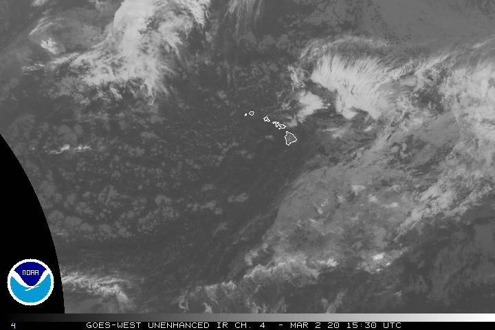
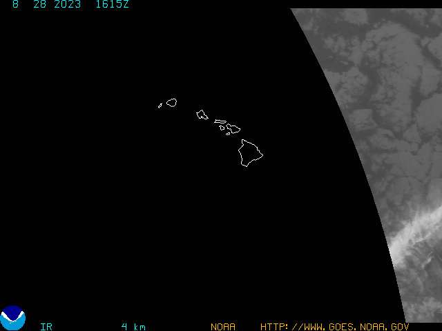
GOES Hawaii SECTOR IR Image

Hawaii goes west infra red sector image


Ascending Pass (QuikSCAT)

The wind vector retrievals thought to be rain contaminated are colored in black. While not perfect, the MUDH rain flag appears to mark many of the suspect vectors in regions of probable precipitation, epecially in the tropical latitudes. Rain can contaminate the wind retrievals, especially in situations with moderate to heavy rain rates.

Descending Pass (QuikSCAT)


Pomaika`i Hawaii!

And if thats not all, we have;


CAT 1
Typhoon SEPAT heading for the Philippines


WAIT theres more! And we have;


Tropical Storm Dean...


[Image of probabilities of hurricane force winds]


Ooops almost missed one,

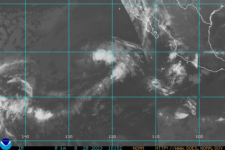
Tropical Depression FIVE


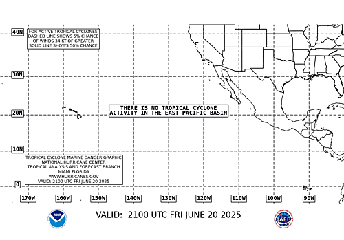
[full basin map of tropical cyclone activity]


RS.....

Tuesday, August 14, 2007

Memo reveals Proenza's days were numbered

Oh the games we play at NOAA/NHC. Here we have another article on Bill Proenza the former Director of the National Hurricane Center. So NOAA can't make up its mind about whether or not Proenza was removed because of his public statements about a critical satellite or because some of the children or staff at the NHC did not like his leadership style.

Lets just say that it remains to be seen whether some of the children ..eh..staff at the NHC who have now lowered the Atlantic Hurricane threat to some13 to 16 named hurricanes can actually live up to their statements.

Seems to me that if there is any question of lowered public confidence its in predicting hurricanes by some of the same children who complained about Proenza's public statements. Wonder if any of them will get relocated if those 13 to 16 named storms don't appear? Though I am now tracking Tropical Depression Four (TD4), think if these 13-16 storms don't develop, it time for some staff changes at the NHC....

Geez we need to grow up...

OrlandoSentinel.com

Memo reveals Proenza's days were numbered

Maya Bell and Mark K. Matthews

Sentinel Staff Writers

August 7, 2007

Days before Bill Proenza's bosses dispatched a team to the National Hurricane Center to evaluate his brief but controversial tenure as director, he already was on notice he would be demoted to an obscure office of the National Weather Service, an internal memo released Monday shows.

The main reason for the transfer, the memo said, was Proenza's repeated misrepresentations to the media about the consequences of losing the aging QuikSCAT satellite.

Two congressmen, whose subcommittees obtained the memo while investigating Proenza's abrupt ouster, suggest the two-page document supports the National Weather Service veteran's contention that he was placed on paid leave July 9 in retaliation for criticizing his superiors at the National Oceanic and Atmospheric Administration, rather than for leadership flaws documented by the assessment team.

Citing the memo, U.S. Reps. Brad Miller, D-N.C., and Nick Lampson, D-Texas, wrote to NOAA Administrator Conrad Lautenbacher last week, saying Proenza was being treated unfairly. They also said that if NOAA intends to permanently remove Proenza from the hurricane center, he should be returned to his former $150,000-a-year job as the director of the 10-state southern region of the National Weather Service.

'Extremely talented'

"We don't want this extremely talented public employee consigned to NOAA's backwaters because he spoke publicly about the potential loss of a critical satellite," Lampson said in a statement.

An NOAA spokesman would not comment. Proenza's attorneys, who are considering filing a lawsuit alleging retaliation under the federal Whistleblower Protection Act, could not be reached.

The previously undisclosed memo was from Mary Glackin, acting director of the National Weather Service, and Louis Uccellini, director of the National Centers for Environmental Prediction. Though the memo is undated, it was obviously written on or before June 22, the date the memo says Proenza was being "detailed immediately out" of the director's job in the Miami center and reassigned to NOAA's Office of Climate, Water and Weather Services in Camp Springs, Md.

In the memo, Glackin and Uccellini cited complaints from hurricane-center staffers that Proenza had misrepresented them in the media, causing "disarray and distraction" since he assumed the director's job in January. But they made clear that it was Proenza's comments about QuikSCAT that doomed him. He had told members of Congress that the loss of the aging satellite, already several years past its expected lifespan, would make storm-track forecasts as much as 16 percent less accurate.

"This action results from our lack of confidence in your ability to fulfill the responsibilities of your position," the memo said. "You have repeatedly misrepresented facts to the press regarding the impact of the loss of QuikSCAT data resulting in widespread media questioning our ability to deliver effective hurricane services."

Veteran forecasters said Proenza, by exaggerating the importance of QuikSCAT, had undermined the center's credibility and the public's faith in their forecasts. They said the satellite is a useful tool but they rely far more on data collected from reconnaissance aircraft to track approaching storms.

Why Proenza was still on the job when the five-member inquiry team showed up July 2 is unclear. But three days later, half of the center's staffers issued a statement calling for his immediate ouster. On July 9, Lautenbacher put him on paid leave.

'Leadership' failure

But the NOAA director, testifying before both Miller's and Lampson's subcommittees on July 19, denied that Proenza's QuikSCAT comments were responsible for his suspension. Instead, he cited the inquiry team's recommendation that Proenza be moved "due to his failure to demonstrate leadership" and not for "his public statements about the QuikSCAT satellite or NOAA leadership."

According to the NOAA Web site, the Office of Climate, Water and Weather Services oversees hydrometeorological and climate services and the design and implementation of future products and services. Its training chief "ensures NWS staff receives the training required to attain/maintain proficiency in providing accurate and timely forecasts and warnings to the public." The prior training chief was to have retired June 30.

Maya Bell, who reported from Miami, can be reached at mbell@orlandosentinel.com or 305-810-5003. Mark K. Matthews, who reported from Washington, can be reached at mmatthews@tribune.com or 202-824-8222.

Weather Story

[full basin map of tropical cyclone activity]


RS.....

Monday, August 13, 2007

50 drowned, 100 missing in Sierra Leone as boat capsizes

Aug 3, 2007 FREETOWN, Sierra Leone (Reuters) -- Around 50 people were feared drowned and more than 100 were missing after their boat capsized in heavy rain at the mouth of a river in Sierra Leone, police said on Friday.

A spokesman for a local boat owners' association said seven bodies had so far been recovered from the sea at the estuary of the Great Scarcies River, near Sierra Leone's northern border.

Police in the northern Kambia district estimated around 50 people had died based on accounts from the only two survivors found so far.

The boat, which was en route from the coastal capital Freetown to the riverside town of Rokupr, was believed to be carrying around 200 passengers when it ran into the choppy river waters, swollen by a week of torrential rains.

"Members of the Sierra Leone navy, backed by some members of the boat association, left in the early hours for the disaster scene to join local fishermen who have been searching since the tragedy took place," said the spokesman for the boat owners' association, Michael Asuman.

Authorities say that the heavy rains have washed away scores of homes in the hilly Freetown area over the last week, leaving more than 500 people on the streets.

Boating accidents are common during Sierr Leonea Leone's treacherous rainy season. Some 25 people drowned in July last year when a wave overturned their boat at the mouth of the Great Scarcies river.

Many of the vessels plying trade and passenger routes on inland waterways and off West Africa's coast are poorly maintained, with accurate passenger manifests a rarity.

Copyright 2007 Reuters. All rights reserved.This material may not be published, broadcast, rewritten, or redistributed.

Martiime Notes:

This from my shipmate at gCaptain.com
Tanker Grounded off Coney Island, NY

After experiencing a steering problem the tanker “White Sea” ran aground off of Coney Island New York. The Gotahamist tells us: Continue reading at gCaptain.com .

Casualties from Cargolaw.com:

Cari-carrier M/V Nobleza, Monrovia-flagged, was caught by strong wind and pushed against pilings in the Kiel Canal with its port side while passing from Brunsbuettel to Kiel-Holtenau on Aug. 5. The vessel lated resumed its voyage with minor dents. From our Sr. Correspondent Tim Schwabedissen (Thurs. Aug. 9 2007)

F/V Zhu Wan 4209 sank in a tropical storm in the waters of the Xisha Islands in the South China Sea on Aug 3. All five abaord were rescued by 35,500-ton German container M/V Northern Faith. From our Sr. Correspondent Tim Schwabedissen (Thurs. Aug. 9 2007).

Weather Story:

CHINA:Thousands of China homes flooded. More than 3,600 homes in southern China have been destroyed by floods resulting from a now fading tropical storm, Chinese state media has reported. The floods in Guangdong province have affected about 1.2 million people and caused an estimated 1.3bn yuan ($171m) of damage, Xinhua news agency said. The rain was caused by Tropical Storm Pabuk, which hit Hong Kong on Friday, disrupting transport and business.

The latest on Hurricane Flossie:

HONOLULU, Hawaii (AP)
-- Hurricane Flossie strengthened to a Category 4 storm Saturday as it spun more than 1,000 miles south of Hawaii.
art.flossie.satellite.noaa.jpg

Satellite image taken at 10:30 a.m. ET shows Flossie's position relative to Hawaii.

At 11 a.m. EDT, Flossie had intensified with maximum sustained winds near 132 mph, and was about 1,100 miles southeast of Hilo, Hawaii. Flossie was upgraded to Category 3 from a Category 1 overnight.

The storm was expected to weaken later in the day as it passed over cooler waters. It was traveling west at about 12 mph.

Jeff Powell, lead forecaster at the National Weather Service in Honolulu, said Flossie hadn't changed its course and was expected to pass the Hawaiian Islands early Wednesday with rough surf. A "ramp up" of surf on the Big Island was expected late Monday.

The island's southeastern shores could see waves of 8 to 12 feet, forecasters said, with the surf rising during the day Monday and peaking Tuesday. The island's South Point is the southernmost area of the United States.

State civil defense officials urged residents to be prepared because of the unpredictable nature of hurricanes. A one or two degree direction change, they say, could make a big difference.

"If this thing fizzles out, so what? Everybody should still be prepared," said Dave Curtis, spokesman for the state Civil Defense Agency.

Flossie formed as a tropical storm Wednesday about halfway between Mexico's southern Pacific coast and Hawaii. Its winds surpassed 74 mph, making it a hurricane, on Friday.

The last time a hurricane hit Hawaii was in 1992, when Iniki ravaged Kauai, killing six people and causing $2.5 billion in damage.

Hurricane season runs from June 1 to Nov. 30. In May, forecasters predicted that Hawaii and the rest of the central Pacific face a slightly below-average hurricane season, with just two or three tropical cyclones expected because of lower sea surface temperatures.The islands get an average of 4.5 tropical cyclones a year and one hurricane about every 15 years. Last year, the central Pacific had five tropical cyclones after the National Oceanic and Atmospheric Administration predicted two to three.

On July 21, a tropical depression moved past the Big Island, bringing a few inches of rain to the parched island but no major problems. Cosme, the year's first Pacific tropical cyclone, reached hurricane status for a day before it weakened.

Finally, how about a little rough seas off of the coast of Japan?


RS

Saturday, August 11, 2007

Hurricane Flossie

I am tracking Hurricane Flossie, currently tracking,

AS OF 500 AM PDT...1200 UTC...THE CENTER OF HURRICANE FLOSSIE HAS NOT YET CROSSED 140 DEGREES WEST LONGITUDE INTO THE CENTRAL PACIFIC HURRICANE BASIN. THEREFORE...THE NEXT ADVISORY WILL AGAIN BE ISSUED BY THE NATIONAL HURRICANE CENTER IN MIAMI FLORIDA.

=


I will keep you posted...
RS

Friday, August 10, 2007

NOAA UPDATES ATLANTIC HURRICANE SEASON OUTLOOK

NOAA UPDATES ATLANTIC HURRICANE SEASON OUTLOOK
Above-Normal Season Still Expected

NOAA image of NOAA’s 2007 Atlantic hurricane season update.August 9, 2007 — NOAA’s Climate Prediction Center today released its update to the 2007 Atlantic Hurricane Season Outlook, maintaining its expectations for an above-normal season.

As we enter the peak months (August through October) of the Atlantic hurricane season, NOAA scientists are predicting an 85 percent chance of an above-normal season, with the likelihood of 13 to 16 named storms, with seven to nine becoming hurricanes, of which three to five could become major hurricanes (Category 3 strength or higher on the Saffir-Simpson Hurricane Scale). (Click NOAA image for larger view of NOAA’s 2007 Atlantic hurricane season update. Click here for high resolution version. Please credit “NOAA.”)

The development of key climate factors through early August has increased the confidence of an above-normal season, and has also led the NOAA team to slightly tighten the ranges that had been given in their May outlook — due to development of La Niña-like conditions exerting influence. In May, NOAA predicted a range of 13-17 named storms, with seven to 10 becoming hurricanes, and three to five becoming major hurricanes.

NOAA image of conditions in the Atlantic Basin that can produce an above normal hurricane season. Please credit “NOAA.”The climate patterns responsible for the expected above-normal 2007 hurricane season continue to be the ongoing multi-decadal signal (the set of oceanic and atmospheric conditions that have spawned increased Atlantic hurricane activity since 1995), warmer-than-normal sea surface temperatures in key areas of the Atlantic Ocean and Caribbean Sea, and the El Niño/La Niña cycle, according to Gerry Bell, Ph.D., lead seasonal hurricane forecaster at NOAA’s Climate Prediction Center based in Camp Springs, Md. (Click NOAA image for larger view of conditions in the Atlantic Basin that can produce an above normal hurricane season. Click here for high resolution version. Please credit “NOAA.”)

“Most of the atmospheric and oceanic conditions have developed as expected, and are consistent with those predicted in May,” said Bell. “The biggest wild card in the May outlook was whether or not La Niña would form, and if so, how strong it would be.

“Today’s El Niño/La Niña forecast from the Climate Prediction Center indicates a slightly greater than 50 percent probability that La Niña will form during the peak of the hurricane season. But more importantly, we are already observing wind patterns similar to those created by La Niña across the tropical Pacific Ocean and Caribbean Sea that encourage tropical cyclone development. The conditions are ripe for an above-normal season.”

NOAA image of historical tropical cyclone frequency. Please credit “NOAA.”NOAA’s seasonal outlooks do not specify where and when tropical storms and hurricanes could strike. Nevertheless, during above-normal seasons many of the storms form over the tropical Atlantic Ocean. These systems generally track westward, towards the United States and the Caribbean Sea, thereby posing an increased threat to these regions. (Click NOAA image for larger view of historical tropical cyclone frequency. Click here for high resolution version. Please credit “NOAA.”)

So far this season, there have been three Atlantic named storms (Andrea, Barry and Chantal), which is slightly above average. On average, one to two storms develop in June and July. The Atlantic hurricane season runs from June 1 through November 30.

The 2007 Atlantic Hurricane Season outlook is a joint product of the scientists at NOAA’s Climate Prediction Center, National Hurricane Center, Hurricane Research Division, and Hydrometeorological Prediction Center. NOAA meteorologists use a suite of sophisticated computer forecast models and high-tech tools to forecast tropical storms and hurricanes. Scientists rely on information gathered by NOAA and U.S. Air Force Reserve personnel who fly directly into storms in hurricane hunter aircraft; NOAA, NASA and Department of Defense satellites; a network of Doppler radars and buoys and partners among the international meteorological services.

NOAA is dedicated to enhancing economic security and national safety through the prediction and research of weather and climate-related events and information service delivery for transportation, and by providing environmental stewardship of our nation's coastal and marine resources. Through the emerging Global Earth Observation System of Systems (GEOSS), NOAA is working with its federal partners, more than 70 countries and the European Commission to develop a global monitoring network that is as integrated as the planet it observes, predicts and protects.

Relevant Web Sites
Updated 2007 Atlantic Hurricane outlook (technical product)

Climate Prediction Center’s ENSO Diagnostic Discussion/Forecast


NOAA Weather Radio All Hazards

Hurricane-Related Services Provided by NOAA: Fact Sheet

NOAA Weather Radio All Hazards: On Alert For All Emergencies

Media Contact:
Carmeyia Gillis, NOAA Climate Prediction Center, (301) 763-8000 ext. 7163


Maritime Notes:


UK – update re MSC NAPOLI The Devon County Council issued a Situation Update regarding the wreck of the MSC NAPOLI. The bow section is scheduled to be towed to Belfast for recycling. Contracts are under discussion for removal of the stern section, which remains grounded. (8/8/07).


Weather Story - Chicagoland:
NZUS51 KLOT 100918
WRKLFP
ILZ005-006-012>014-022-INZ001-102100-

CHICAGO METROPOLITAN FORECAST
NATIONAL WEATHER SERVICE CHICAGO/ROMEOVILLE IL
400 AM CDT FRI AUG 10 2007

TODAY...PARTLY CLOUDY AND LESS HUMID. HIGHS FROM THE MIDDLE 80S
NORTH SHORE TO AROUND 90 SOUTH AND SOUTHWEST SUBURBS. NORTHWEST
WINDS AROUND 10 MPH BECOMING NORTHEAST.
TONIGHT...FAIR. LOWS FROM THE MIDDLE 60S FAR WEST SUBURBS TO THE
LOWER 70S DOWNTOWN. NORTHEAST WINDS 5 TO 10 MPH BECOMING LIGHT AND
VARIABLE.
.SATURDAY...SUNNY AND WARM. HIGHS 85 TO 90...COOLEST LAKESIDE. WINDS
BECOMING SOUTHEAST AROUND 10 MPH.
.SATURDAY NIGHT...PARTLY CLOUDY. LOWS AROUND 70. SOUTHEAST WINDS
AROUND 10 MPH BECOMING SOUTHWEST.
.SUNDAY...BECOMING MOSTLY CLOUDY. HIGHS AROUND 90...BUT TURNING
COOLER IN THE AFTERNOON. SOUTHWEST WINDS AROUND 10 MPH BECOMING
NORTHEAST IN THE AFTERNOON.
.SUNDAY NIGHT...PARTLY CLOUDY. LOWS IN THE UPPER 60S.
.MONDAY...MOSTLY SUNNY. HIGHS IN THE UPPER 80S.
.MONDAY NIGHT...PARTLY CLOUDY. LOWS 65 TO 70.
Stay cool, stay dry and stay safe.
RS

Thursday, August 9, 2007

Crazy Weather


Where do we start? Chicago had tornado warnings with 3.50 " of rain per hour and Brooklyn got hit with a EF2 Tornado. But thats not all. While its quiet in the Atlantic there have been some 12 Typhoons in the Pacific, with another four tropical depressions under watch. Flood's? Try China and Britain are competing for the worlds largest ark contest. Lets not forget New York City! Extreme weather has raged in Bulgaria, Pakistan and even Romania and two tornado's in the Philippines.

So whats in store for us today in Chicagoland? More of the same, so let's sit and watch the sky's and the radar for another day..


Stay cool, stay dry and stay safe...
RS

Wednesday, August 8, 2007

Storm spotter helps others

By JIM MISUNAS, Sentinel Editor


McPherson's Jerry Bruce might save your life someday. He'll offer common-sense advice about safety during severe storms in his lecture at 7 p.m. tonight at the First Baptist Church, 600 E. Marlin.

The National Weather Service advance storm spotter will deliver his talk, “Storm Chasing in Kansas.” Admission is free and anyone may attend.

Bruce offers common-sense advice built on 27 years of storm spotting. He said staples for a well-equipped storm shelter include water, non-perishable food, sturdy shoes and a whistle.

“If you're ever in trouble, a whistle will attract attention more quickly than shouting,” he said. “Plus, you can blow a whistle for a long time after your voice gives out.”

Bruce, the safety coordinator for The Cedars Retirement Center, relays on-site storm conditions to a command center and to local media on storm conditions. He contacts various media sources to view live radar and check on storm movement.

His well-equipped vehicle carries a cell phone, portable TV with antennae and a ham radio. The signal for the American Radio Emergency Services ham radio is helped by repeaters installed in Canton and Marion County.

“The ham radio operators often are able to communicate information if power is down,” Bruce said. “Passing out timely information is a key.”

He considers storm spotting a hobby, albeit dangerous at times. He's had a few close calls and can travel more than 600 miles in a day. Most times, he'll station himself southeast of a severe storm capable of producing tornadoes.


“I'm happy to get out and help people,” he said. “When you're spotting you want to give yourself at least one way to get out of the way of a storm in case it turns your way.”

Bruce said he appreciates his supervisors at The Cedars, who provide him the flexibility to leave work when the forecast calls for the probability of severe weather. That was the case May 4 when Bruce left McPherson to monitor a severe storm in southwest Kansas that developed into an EF-5 tornado.

“I was watching TV that day and when I saw a storm was southwest of Greensburg, I decided to head down there,” he said.

When another storm spotter was unable to report conditions near Greensburg, Bruce was the primary source of information for KAKE, Ch. 10. Bruce was close enough that he monitored winds topping 90 mph east of Macksville. He tracked the storm from Kiowa County to Barton County.

“I knew it was a serious tornado and there was a high probability that people had died,” Bruce said. “I told Jay Prater of Channel 10 that the storm meant business because it was causing severe damage. Greensburg took a direct hit.”

Ten people died from the storm, a toll that would've been worse had the people in Greensburg not heeded the 30-minute advance warning provided by the National Weather Service in Dodge City.

“People fortunately got the heck out of town, which no doubt saved some lives,” Bruce said. “A National Weather Service meteorologist in Dodge City saw there was no other storm that would slow the storm down. He issued a timely warning that saved a lot of lives.”

Weather Story - Chicago


HEAVY RAIN POSSIBLE ACROSS NORTHERN ILLINOIS TONIGHT INTO EARLY THURSDAY MORNING..

UNTIL 12:45PM CDT

Urgent - Immediate Broadcast Requested Flood Watch National Weather Service Chicago/Romeoville IL 432 AM CDT Wed Aug 8 2007

...Heavy Rain Possible Across Northern Illinois Tonight Into Early Thursday Morning...

.An Upper Level Disturbance Across The Rockies Will Race Into The Upper Mississippi River Valley Tonight. Southerly Flow In Advance Of This Short Wave Will Continue To Bring Very Warm And Moist Low Level Air Into The Region. The Combination Of This Disturbance And The Moist Air Mass Will Create A Potential For Heavy Rainfall Tonight.

Winnebago-Boone-Mchenry-Lake Illinois-Ogle-Lee-De Kalb-Kane- Dupage-Cook- Including The Cities Of...Rockford...Woodstock...Waukegan... Oregon...Dixon...Dekalb...Aurora...Chicago 432 AM CDT Wed Aug 8 2007

...Flash Flood Watch In Effect From This Evening Through Thursday Morning...

The National Weather Service In Chicago Has Issued A

• Flash Flood Watch For Portions Of North Central Illinois And Northeast Illinois...Including The Following Areas...In North Central Illinois...Boone...De Kalb...Lee...Ogle And Winnebago. In Northeast Illinois...Cook...Dupage...Kane...Lake Illinois And Mchenry.

• From This Evening Through Thursday Morning

• Thunderstorms Are Expected To Spread Into Northern Illinois Tonight. These Thunderstorms Will Have The Potential To Produce Heavy Rainfall Late This Evening Into Early Thursday Morning. Many Locations In The Watch Area Have Received Very Heavy Rainfall Over The Past Few Days...And Additional Heavy Rainfall Tonight Into Early Thursday Morning May Lead To Flash Flooding.

A Flash Flood Watch Means That Conditions May Develop That Lead To Flash Flooding. Flash Flooding Is A Very Dangerous Situation.

You Should Monitor The Latest Forecasts And Be Prepared To Take Action Should Flash Flood Warnings Be Issued.


Stay cool, stay dry, stay safe...

RS

Tuesday, August 7, 2007

HER MAJESTY'S SERVICE HONORS AMERICA'S HERO


By KRISTI LANGENBACHER Correspondent Sunday, August 05, 2007

A Coast Guard rescue three months ago led to an opportunity to promote international relations this week. Members from Air Station Elizabeth City were invited to tour two Royal Navy ships visiting Norfolk, Va. on Tuesday.

The invitation was the result of a rescue which involved a British citizen three months ago.

An HH-60 helicopter and a C-130 airplane responded to a distress call from a sailboat 200 nautical miles off the coast of North Carolina on May 7. The crews rescued three men from the stormy waters that day.

Members of both aircrews traveled to Norfolk on Tuesday. The HH-60 helicopter crew of Petty Officer Drew Dazzo, Petty Officer Scott Higgins, Lt. j.g. Aaron Nelson and Lt. Cmdr. Nevada Smith attended the event. Lt. Paul Beavis and Petty Officer Marcus Jones, members of the C-130 airplane crew, attended as well.

They traveled to Naval Station Norfolk to tour two ships from Her Majesty's Service, or HMS. The aircrew members met the crews and toured the HMS Illustrious and the HMS Manchester.

The tour was arranged after a survivor who was rescued by the Air Station Elizabeth City crews wrote a letter recognizing the crews for their rescue on May 7. The crews rescued Canadian citizen Rudy Snel, American citizen Jean Pierre de Lutz, and Ben Tye, a British citizen.

Snel's son wrote a letter to Capt. Mike Andres, commanding officer of Air Station Elizabeth City, encouraging formal recognition of the rescue crews. He also sent copies of the letter to several government officials, including President George Bush, British Prime Minister Tony Blair and the British Consulate General's office in Atlanta.

The British Consulate then contacted the air crews.
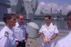


"Because of the survivors, the British Consulate in Atlanta arranged a tour to thank us for what we did for the British National," said Smith, aircraft commander of the HH-60 helicopter involved in the rescue.

Smith said the tour was also an opportunity to raise public awareness about the Coast Guard, and to promote international relations. He described the British sailors as sociable, friendly and interesting. The aircrews handed out Coast Guard coins and books to the British sailors, and received DVDs about the Royal Navy.

"For us, we got to show the British sailors some Coast Guard people and let them know what we do," Smith said. "And in return, we learned about the Royal Navy and met some really great people."

The men toured the ships, including the search and rescue helicopter, command centers, avionics repair shop and bridge.

Dazzo, the rescue swimmer who pulled the men from the water on May 7, said the experience was an opportunity to see how another country's military operates.

"It was a learning experience because their operations are similar to our Navy, but how they go about doing them is a little bit different," Dazzo said.

He called the rescue the most challenging rescue of his 10 years in the Coast Guard.

"It's probably the rescue I've prepared for my entire career," Dazzo said. "With high winds, rough seas and very low visibility - it's what you train for."

The crews rescued the three men from their partially-inflated life raft after their sailboat capsized twice during Subtropical Storm Andrea.

Dazzo said writing a letter of recognition is one of the many things the survivors have done since the rescue.

"The guys we rescued really want to see us in the limelight," he said. "The exposure they've given us is really amazing."

One of the survivors also wrote a letter to Dazzo's 13-year-old daughter letting her know how fragile life is and how much he appreciated Dazzo's efforts. The same man also sent a balloon bouquet to Dazzo's son on his second birthday.

This guy has gone above and beyond," Dazzo said. "We didn't expect any of this. Just a thank you when we dropped him off out of the helicopter was enough."

Another highlight of the group's tour of the Royal Navy ships was meeting up with members of the U.S. Marine Corps. The British ships were conducting joint training exercises with the U.S. Marines using the curved ramp on the Illustrious for launching Harrier Jump Jets.

The jets use thrust-vectoring for vertical/short takeoff and landing from the curved ramp on the deck of the ship.

"They told me they conducted 150 landings and take-offs in a 14-hour period," Smith said. "That's pretty amazing."

Dazzo called the flight operations that day impressive, and said the design of the ship was interesting as well.

"The bridge and the air operations were open, and together," he said. "That way the ship crew and the aircrews can communicate more effectively."

The HMS Illustrious is an Invincible-class light aircraft carrier home-ported in Portsmouth Harbour in England. The HMS Manchester is a Type 42 guided missile destroyer with a medium-range missile system.

Weather Story- Chicago, Illinois.

Well in Chicago since 1 August its been hot, humid and muggy. Highs ranging between 90 to 113 in Talyorville. Yesterday was no better and we got punched hard by Mother Nature. At one point yesterday (Monday) evening more than 3,000 cloud-to-ground lightning strikes in 10 minutes were recorded, some very impressive especially in parts of the south and western suburbs. DeKalb County was ground zero for the heaviest storms. WGN reported "3.82” of rain fell between 3:50 p.m. and 6:50 pm—2.90” of it in just 30 minutes".

The outlook for today is not much better, NWS already has Flash Flood Warnings out for Cook and Dekalb counties until 2:30PM CST, so lets watch the radar (brought to you by NexLab) and the skys...


Flood Statement National Weather Service Chicago/Romeoville IL 931 AM CDT Tue Aug 7 2007

Winnebago IL-Mchenry IL-Boone IL-Lake IL-Ogle IL-Cook IL-Kane IL- Dekalb IL- 931 AM CDT Tue Aug 7 2007

...The Flood Warning Remains In Effect Until 230 PM CDT For Northern Dekalb...Northern Kane...Northern Cook...Northeastern Ogle...Lake... Boone...Mchenry And Winnebago Counties...

At 931 AM CDT...National Weather Service Doppler Radar Estimates And Rainfall Observers Have Reported A Swath Of 3 To 7 Inches Of Rain That Has Fallen From Southern Winnebago County Eastward Into Central Lake County. The Heaviest Rainfall Reports Have Been In The Rockford Area Where Over 6 Inches Of Rain Has Fallen. Rain Has Subsided This Morning...But Some Roads Remain Closed Due To Flooding.

A Flood Warning Means That Flooding Is Imminent Or Has Been Reported. Stream Rises Will Be Slow And Flash Flooding Is Not Expected. However...All Interested Parties Should Take Necessary Precautions Immediately.

Do Not Drive Your Vehicle Into Areas Where The Water Covers The Roadway. The Water Depth May Be Too Great To Allow Your Car To Cross Safely. Move To Higher Ground.

Do Not Attempt To Cross Water Covered Bridges...Dips...Or Low Water Crossings. Never Try To Cross A Flowing Stream...Even A Small One...On Foot. To Escape Rising Water Move Up To Higher Ground.

Lat...Lon 4220 8939 4216 8928 4212 8921 4205 8906 4199 8894 4199 8853 4201 8766 4220 8781 4235 8785 4238 8781 4248 8780 4249 8939

Stay cool and stay dry!

RS

Monday, August 6, 2007

2007 inaugural IMO Award for Exceptional Bravery at Sea

2007 inaugural IMO Award for Exceptional Bravery at Sea to be awarded to Searose G seafarers for dramatic rescue of Teklivka crew

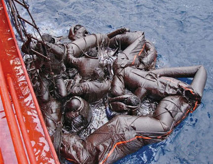
( Left, Rescued Tanker Crew Covered in Oil Photo Courtesy Searose G)

Council - 98th session: 25-29 June 2007

Two officers from the 83,155 dwt Bahamas-registered oil/bulk ore carrier Searose G have been selected to receive the inaugural 2007 IMO Award for Exceptional Bravery at Sea, in recognition of their part in a dramatic rescue in severe weather.

The IMO Council, at its 98th session in London, agreed with two Panels of international assessors and judges that Second Officer Mustafa Topiwala of the Searose G and Captain Zvonimir Ostric (who was on the vessel as onboard trainer at the time of the incident) had displayed exceptional bravery in the rescue of the remaining survivors from the sunken vessel Teklivka, in the eastern Mediterranean, in March 2006. They were nominated by the Bahamas and by the International Federation of Shipmasters' Associations (IFSMA).

The Bahamas-registered Searose G was on passage through the Mediterranean, bound for the Suez Canal, when it responded to a distress call from the Maltese-flagged Teklivka, which was sinking 50 miles south in gale force winds. The Teklivka had sunk when the Searose G reached the scene but a dramatic rescue ensued, with Searose G rescuing nine crew and another vessel picking up three crew members. Tragically, three crew members of the Teklivka were lost.

The assessment and judging panels considered that Second Officer Topiwala and Captain Ostric placed their own lives in jeopardy, even though they were not trained professional rescuers, by undertaking acts that went well beyond the scope of their normal duties. They left the comparative safety of their ship, descending to a liferaft filled with oil and water. Second Officer Topiwala then entered the sea, in extremely hazardous weather conditions, during the rescue.

Mr. Topiwala and Captain Ostric will be invited to receive the award at a special ceremony to be held during the IMO Assembly, to be held from 19 to 30 November 2007 in London. They will each receive a medal and a certificate citing the act of exceptional bravery performed.

"I am delighted that the assessment and judging of nominations for this inaugural Bravery Award has met the high expectations of all concerned and that we have, in Second Officer Mustafa Topiwala and Captain Zvonimir Ostric, truly exemplary and meritorious winners," IMO Secretary-General Mr. Efthimios E. Mitropoulos said. "I congratulate them both wholeheartedly and look forward to doing so personally, at the Award ceremony during the IMO Assembly."

Mr. Mitropoulos noted that the Award was launched "so that the international maritime community could honour the very best of human qualities - bravery, courage, selflessness - and there is no doubt that all other nominees for the 2007 Award have also shown just that and are deserving of our respect."

The IMO Council agreed with the recommendations of the assessment and judging panels that the following nominees, the first two of which were also shortlisted for the Award, should be recognized by receiving certificates citing their respective acts of bravery:

  • The Hong Kong Government Flying Service, nominated by China, for courageous actions that went well above those expected of a professional rescue service. The assessment and judging panels considered that members of the Hong Kong Government Flying Service clearly risked their own lives to rescue 91 crew members of the vessel Wing on IV and the barge Hai Yang Shi You 298 (in August 2006) during the course of three consecutive aircraft/helicopter operations carried out in severe typhoon weather conditions, at some 170km and 132km southwest of Hong Kong, China, respectively.
  • Captain Xufeng Zu of the diving squad of Quinghuangdao Base of Beihai Rescue Bureau of China Rescue and Salvage (CRS). Captain Xufeng Zu was nominated by the International Lifeboat Federation (ILF) for a selfless act of bravery in August 2006. During the course of a professional operation involving two consecutive dives to locate and rescue the crew from the upturned hull of the capsized bulk carrier Fu Hua 1 (41 miles off Quinghuangdao, China), Captain Zu gave up his own breathing equipment, with no guarantee that he would survive, thereby placing his own life at risk so that two remaining survivors could be saved, before he himself was able to leave the stricken vessel.
  • Dr. Christine Jane Bradshaw (a civilian nominated by the ILF), for descending on a winch in rough weather, having been to sea only once before in benign conditions, to assist in treating and rescuing the last surviving crew member of the tanker FR8 Venture, in the Pentland Firth, Scotland, in November 2006;
  • The crew of the ocean-going rescue tug Nanhaijiu III, of Nanhai Rescue Bureau (nominated by China), for a series of successful rescue missions since the rescue tug was put into service in March 2006, including the location and rescue of 14 small Vietnamese fishing boats during typhoon Chanchu, in May 2006;
  • Mr. Brett Churcher, skipper of the fishing boat Striker (nominated by ILF), for prompt and effective actions which led to the saving of the lives of a man and his four-year old daughter off Cape Palliser, New Zealand, in April 2007;
  • The crews of the fast action lifeboats and vessels of the Spanish Maritime Safety Agency (nominated by Spain), for a series of successful operations to locate and recover safely, thousands of migrants at sea. Between March 2006 and February 2007, 30,493 migrants were assisted by the Spanish rescue services in the Atlantic and the Mediterranean;
  • Viktors Timoscenko, Master of the Latvian-registered tanker Ance (nominated by IFSMA), for persisting in the successful rescue of two persons adrift on a catamaran, after other efforts had been called off, during an operation that lasted almost 14 hours at night time, some 834km off Cape Cod, United States, in November 2006; and
  • Station Officer Kekoi Jaiteh, of the West Gambia Fire Department (nominated by ILF), for actions which resulted in the saving of the captain and three crew members from a capsized cargo vessel in rough inshore waters, in January 2007.

The IMO Council endorsed the view of the judging panel that the 11 remaining individuals or services that had also been nominated for the 2007 Award should each receive a letter of commendation.

The IMO Award for Exceptional Bravery at Sea was established by the Organization to provide international recognition for those who, at the risk of losing their own life, perform acts of exceptional bravery, displaying outstanding courage in attempting to save life at sea or in attempting to prevent or mitigate damage to the marine environment.

Nominations for 21 acts of bravery were received for the 2007 Award, from nine Member States and three non-governmental organizations in consultative status. The nominations focused on such factors as location of the incident; prevailing weather conditions; skill displayed; leadership demonstrated; determination to conduct the rescue operation; exceptional courage demonstrated; and degree of risk (to human lives and/or the marine environment) involved.

The nominations were scrutinized initially by the Assessment Panel made up of members of non-governmental organizations* in consultative status with IMO, which met at IMO on 30 May 2007, under the chairmanship of the Secretary-General.

The Panel of Judges met at IMO Headquarters on 22 June 2007 (under the chairmanship of the Chairman of the IMO Council, and with the participation of the Acting Chairman of the Maritime Safety Committee and the Chairmen of the Marine Environment Protection Committee, the Legal Committee and the Facilitation Committee) to consider the recommendations of the Assessment Panel and to select the recipient of the Award.

* The International Shipping Federation Limited (ISF); the International Confederation of Free Trade Unions (ICFTU); the International Maritime Pilots' Association (IMPA); the International Federation of Shipmasters' Associations (IFSMA); the International Salvage Union (ISU); the International Lifeboat Federation (ILF); and the International Christian Maritime Association (ICMA).

RS


Friday, August 3, 2007

Dream cruise to Vanuatu turns to 'holiday from hell

5:00AM Friday July 13, 2007
By Eloise Gibson

Passengers on a Pacific Star (video courtesy of tallpappy74 ) cruise were so ill as the ship was battered by storms off Auckland that they have been given free doctors' visits and $100 vouchers.

About 1000 passengers left Auckland on Tuesday for an eight-night cruise and were hit by the atrocious conditions.

People on board reported passengers being sick and damage to the boat by swells of up to 10m.

One passenger said the dream trip to Vanuatu had started like the holiday from hell.

P&O Cruises spokeswoman Sandy Olsen said some of the ship's external windows and doors, as well as its television satellite equipment, were damaged in the storm.

"It would have been an uncomfortable couple of days for the people on board," she said.

"As you can imagine, some people were unwell due to seasickness."

Conditions were so bad the ship has cancelled a planned stopover in Lifou, New Caledonia, and will head straight for Vila to make its scheduled Friday night stopover.

Ms Olsen said passengers would get $100 spending money and P&O would waive doctors' charges for those who needed medical help during the storm.


Here is an oldie but goodie. How would you like to see this type of wave coming at you? This the German cargo ship MV Taifun back in 1976, location the English Channel, searching for survivors of a sinking Russian ship. Hold on to your shorts!


Lastly this is a video of the M/V Napoli being split in two...


UK – update on MSC NAPOLI

The Devon County Council issued a Situation Update regarding the MSC NAPOLI. The bow section is at anchor offshore. An emergency towing bridal has been rigged. The stern section remains aground and is stable. Small amounts of oil continue to emanate from the two sections. (7/27/07)... Holland and Knight LLP

Maritime Notes:

Coast Guard Day – 2007

Tomorrow, August 4, 2007, marks the 217th anniversary of the adoption by Congress of legislation to establish a “system of cutters” to protect the revenue of the young United States of America. As indicated in Coast Guard History, other missions were added over the years and other agencies were merged to form the modern United States Coast Guard. Semper Paratus! Thanks Dennis!

Weather Story:

Typhoon USAGI
Aug. 3 (Bloomberg) -- Typhoon Usagi swept across Kyushu, leaving at least 18 people hurt and bringing torrential rain to the southwestern Japanese island before weakening into a tropical storm. About 6,100 people were stranded by canceled flights.

Chicagoland weekend weather... HOT.. HUMID.. MUGGY, chance of T-Storms and great beach weather... Stay cool and have a great weekend!

RS

Thursday, August 2, 2007

Third in a Series; Subsea Atmospheres - Waves

Waves in the environment
By
Dr J Floor Anthoni

Without waves, the world would be a different place. Waves cannot exist by themselves for they are caused by winds. Winds in turn are caused by differences in temperature on the planet, mainly between the hot tropics and the cold poles but also due to temperature fluctuations of continents relative to the sea.
Without waves, the winds would have only a very small grip on the water and would not be able to move it as much. The waves allow the wind to transfer its energy to the water's surface and to make it move. At the surface, waves promote the exchange of gases: carbon dioxide into the oceans and oxygen out. Currents and eddies mix the layers of water which would otherwise become stagnant and less conducive to life. Nutrients are thus circulated and re-used. The large ocean currents transport warm water from the tropics to the poles and cold water the other way. They help to stabilise the planet's temperature and to minimise its extremes. For instance, because of warm ocean currents arriving from the north, the temperature of New Zealand is 3-4 degrees higher than it would be without them.

For the creatures in the sea, ocean currents allow their larvae to be dispersed and to be carried great distances. Many creatures spawn only during storms when large waves can mix their gametes effectively.

Coastal creatures living in shallow water experience the brunt of the waves directly. In order to survive there, they need to be robust and adaptable. Thus waves maintain a gradient of biodiversity all the way from the surface, down to depths of 30m or more. Without waves, there would not be as many species living in the sea.

Waves pound rocks and make them erode faster, but sea organisms covering these rocks, delay this process. Waves make beaches by transporting sand from deeper down towards the shore and by washing the sand and removing fine particles. Waves stir and suspend the sand so that currents or gravity can transport it.

Wave motion
Anyone having watched water waves rippling outward from the point where a stone was thrown in, should have noticed how effortlessly waves can propagate along the water's surface. Wherever we see water, we see its surface stirred by waves. Indeed, witnessing a lake or sea flat like a mirror, is rather unusual. Yet, as familiar we are with waves, we are unfamiliar with how water particles can join forces to make such waves.

Waves are oscillations in the water's surface. For oscillations to exist and to propagate, like the vibrating of a guitar string or the standing waves in a flute, there must be a returning force that brings equilibrium. The tension in a string and the pressure of the air are such forces. Without these, neither the string nor the flute could produce tones. The standing waves in musical instruments bounce their energy back and forth inside the string or the flute's cavity. The oscillations that are passed to the air are different in that they travel in widening spheres outward. These travelling waves have a direction and speed in addition to their tone or timbre. In air their returning force is the compression of the air molecules. In surface waves, the returning force is gravity, the pull of the Earth. Hence the name 'gravity waves' for water waves.

In solids, the molecules are tightly connected together, which prevents them from moving freely, but they can vibrate. Water is a liquid and its molecules are allowed to move freely although they are placed closely together. In gases, the molecules are surrounded by vast expanses of vacuum space, which allows them to move freely and at high speed. In all these media, waves are propagated by compression of the medium. However, the surface waves between two media (water and air), behave very different and solely under the influence of gravity, which is much weaker than that of elastic compression, the method by which sound propagates.

The specific volume of sea water changes by only about 4 thousands of 1 percent (4E-5) under a pressure change of one atmosphere (1 kg/cm2). This may seem insignificant, but the Pacific Ocean would stand about 50m higher, except for compression of the water by virtue of its own weight, or about 22cm higher in the absence of the atmosphere. Since an atmosphere is about equal to a column of water 10m high, the force of gravity is about 43 times weaker than that of elastic compression.
Surface tension (which forms droplets) exerts a stress parallel to the surface, equivalent to only one 74 millionth (1.4E-8) of an atmosphere. Its restoring force depends on the curvature of the surface and is still smaller. Nevertheless it dominates the behaviour of small ripples (capillary waves), whose presence greatly contributes to the roughness (aerodynamic drag) of the sea surface, and hence, to the efficiency with which can generate larger waves and currents. (Van Dorn, 1974)

If each water particle makes small oscillations around its spot, relative to its neighbours, waves can form if all water particles move at the same time and in directions that add up to the wave's shape and direction. Because water has a vast number of molecules, the height of waves is theoretically unlimited. In practice, surface waves can be sustained as high as 70% of the water's depth or some 3000m in a 4000m deep sea (Van Dorn, 1974).
Note that the water particles do not travel but only their collective energy does! Waves that travel far and fast, undulate slowly, requiring the water particles to make slow oscillations, which reduces friction and loss of energy.

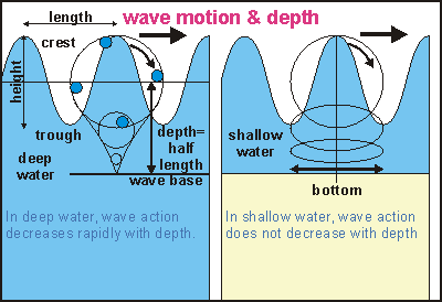
Wave motionIn the diagram some familiar terms are shown. A floating object is observed to move in perfect circles when waves oscillate harmoniously sinus-like in deep water. If that object hovered in the water, like a water particle, it would be moving along diminishing circles, when placed deeper in the water. At a certain depth, the object would stand still. This is the wave's base, precisely half the wave's length. Thus long waves (ocean swell) extend much deeper down than short waves (chop). Waves with 100 metres between crests are common and could just stir the bottom down to a depth of 50m. Note that the depth of a wave has little to do with its height! But a wave's height contains the wave's energy, which is unrelated to the wave's length. Long surface waves travel faster and further than short ones. Note also that the forward movement of the water under a crest in shallow water is faster than the backward movement under its trough. By this difference, sand is swept forward towards the beach.
Water waves can store or dissipate much energy. Like other waves (alternating electric currents, e.g.), a wave's energy is proportional to the square of its height (potential). Thus a 3m high wave has 3x3=9 times more energy than a 1m high wave. When fine-weather waves of about 1m height pound on the beach, they dissipate an average of 10kW (ten one-bar heaters) per metre of beach or the power of a small car at full throttle, every five metres. (Ref Douglas L Inman in Oceanography, the last frontier, 1974). Attempts to harness the energy from waves have failed because they require large structures over large areas and these structures should be capable of surviving storm conditions with energies hundreds of times larger than they were designed to capture.

Waves have a direction and speed. Sound waves propagate by compressing the medium. They can travel in water about 4.5 times faster than in air, about 1500m per second (5400km/s, or mach-4.5, depending on temperature and salinity). Such waves can travel in all directions and reach the bottom of the ocean (about 4km) in less than a second. Surface waves, however, are limited by the density of water and the pull of gravity. They can travel only along the surface and their wave lengths can at most be about twice the average depth of the ocean (2 x 4 km). The fastest surface waves observed, are those caused by tsunamis. The 'tidal wave' caused by an under-sea earthquake in Chile in May 1960, covered the 6000 nautical miles (11,000km) to New Zealand in about 12 hours, travelling at a speed of about 900 km/hr! When it arrived, it caused an oscillation in water level of 0.6m at various places along the coast, 1.4m in Tauranga Harbour and 2.4m in Whitianga harbour. Note that tsunamis reach their minimum at about 6000 km distance. Beyond that, the curvature of the Earth bends the wave fronts to focus them again at a distance of about 12,000 km, where they can still cause considerable damage.

The relationship between wave speed (phase velocity) and depth of long surface waves in shallow water is given by the formula
c x c = g x d x (p2 - p1) / p2 or
c x c= g x d for water/air
where c= wave speed, g= acceleration of gravity (9.8066 m/s/s), d= wave depth (or upper layer depth, m), p2= density of water (=1) and p1= density of air (= 0.00125).
The formula states that wave speed increases with wave depth and the relative difference in density.
For an ocean depth of 4000m, a wave's celerity or speed would be about SQR(10 x 4000) = 200 m/s = 720 km/hr. Surface waves could theoretically travel much faster on larger planets, in media denser than water.


For deep water, the relationship between speed and wavelength is given by the formula:
l = g x t x t / (2 x pi)
l = t x c for all kinds of waves, substitute in above equation: t x c = g x t x t / (2 x pi)
c = g x t / (2 x pi) or t = c x 2 x pi / g or t = c x 0.641 (s)
where t= wave period (sec), f= wave frequency, l= wave length (m) and pi=3.1415...
to calculate c and l from wave period t (in sec): c = t x 1.56 m/s= t x 5.62 km/hr = t x 3.0 knot
l = 1.56 x t x t (metres)
Thus waves with a period of 10 seconds, travel at 56 km/hr with a wave length of about 156m. A 60 knot (110 km/hr) gale can produce in 24 hours waves with periods of 17 seconds and wave lengths of 450m. Such waves travel close to the wind's speed (97 km/hr). A tsunami travelling at 200 m/s has a wave period of 128 s, and a wave length of 25,600 m.
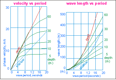
Wave speed, period and length with depthThese two diagrams show the relationships between wave speed and period for various depths (left), and wave length and period (right), for periodic, progressive surface waves. (Adapted from Van Dorn, 1974) Note that the term phase velocity is more precise than wave speed.

The period of waves is easy to measure using a stopwatch, whereas wave length and speed are not. In the left picture, the red line gives the linear relationship between wave speed and wave period. A 12 second swell in deep water travels at about 20m/s or 72 km/hr. From the red line in the right diagram, we can see that such swell has a wave length between crests of about 250m.
When the 12s swell enters 10m shallow water (follow the green curve for 10m), its speed will halve to 10m/s (left graph) and so will its wave length (right graph). But the height of the wave increases by a similar factor (not shown here).

The rougher the water becomes, the easier it is for the wind to transfer its energy. The waves become steep and choppy. Further away from the shore, the water's surface is not only stirred by the wind but also by waves arriving with the wind. These waves influence the motion of the water particles such that opposing movements gradually cancel out, whereas synchronising movements are enhanced. The waves start to become more rounded and harmonious. Depending on duration and distance (fetch), the waves develop into a fully developed sea.

Anyone familiar with the sea, knows that waves never assume a uniform, harmonious shape. Even when the wind has blown strictly from one direction only, the resulting water movement is made up of various waves, each with a different speed and height. Although some waves are small, most waves have a certain height and sometimes a wave occurs which is much higher.

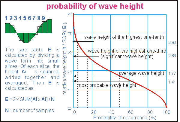
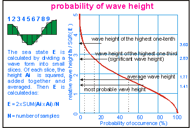
Wave height probabilityWhen trying to be more precise about waves, difficulties arise: how do we measure waves objectively? When is a wave a wave and should be counted? Scientists do this by introducing a value E which is derived from the energy component of the compound wave. In the left part of the drawing is shown how the value E is derived entirely mathematically from the shape of the wave. Instruments can also measure it precisely and objectively. The wave height is now proportional to the square root of E.
The sea state E is two times the average of the sum of the squared amplitudes of all wave samples.
The right part of the diagram illustrates the probability of waves exceeding a certain height. The vertical axis gives height relative to the square root of the average energy state of the sea: h / SQR( E ) . For understanding the graph, one can take the average wave height at 50% probability as reference.

Fifty percent of all waves exceed the average wave height, and an equal number are smaller. The highest one-tenth of all waves are twice as high as the average wave height (and four times more powerful). Towards the left, the probability curve keeps rising off the scale: one in 5000 waves is three times higher and so on. The significant wave height H3 is twice the most probable height and occurs about 15% or once in seven waves, hence the saying "Every seventh wave is highest". Click here for a larger version of this diagram.

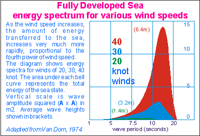
Energy spectra for fully developed seasWhen the wind blows sufficiently long from the same direction, the waves it creates, reach maximum size, speed and period beyond a certain distance (fetch) from the shore. This is called a fully developed sea. Because the waves travel at speeds close to that of the wind, the wind is no longer able to transfer energy to them and the sea state has reached its maximum. In the picture the wave spectra of three different fully developed seas are shown. The bell curve for a 20 knot wind (green) is flat and low and has many high frequency components (wave periods 1-10 seconds). As the wind speed increases, the wave spectrum grows rapidly while also expanding to the low frequencies (to the right). Note how the bell curve rapidly cuts off for long wave periods, to the right. Compare the size of the red bell, produced by 40 knot winds, with that of the green bell, produced by winds of half that speed. The energy in the red bell is 16 times larger!
Important to remember is that the energy of the sea (maximum sea condition) increases very rapidly with wind speed, proportional to its fourth power. The amplitude of the waves increases to the third power of wind speed. This property makes storms so unexpectedly destructive.

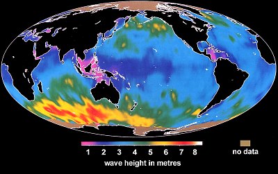
The biggest waves on the planet are found where strong winds consistently blow in a constant direction. Such a place is found south of the Indian Ocean, at latitudes of -40º to -60º, as shown by the yellow and red colours on this satellite map. Waves here average 7m, with the occasional waves twice that height! Directly south of New Zealand, wave heights exceeding 5m are also normal. The lowest waves occur where wind speeds are lowest, around the equator, particularly where the wind's fetch is limited by islands, indicated by the pink colour on this map. However, in these places, the sea water warms up, causing the birth of tropical cyclones, typhoons or hurricanes, which may send large waves in all directions, particularly in the direction they are travelling.

For the complete series visit: Seafriends.org

Weather Story;

Typhoon Usagi is tracking closer to Japan and expect to hit the island today. To top that one, a small tsunami hit the Japanese Island of Hokkaido, no damage was reported. Tropical Storm Eric is still spinning in he eastern pacific and TS Chantel is off the NHC radar.


RS