Wednesday, December 26, 2007

NASSG Oceanographers Guide Ships Through the Storm

NASSG Oceanographers Guide Ships Through the Storm

Story Number: NNS071215-06
Release Date: 12/15/2007 9:57:00 PM

By Mass Communication Specialist 1st Class (AW/SW) Leslie L. Tomaino, Nassau Strike Group Public Affairs

NORFOLK (NNS) -- As the ships of the Nassau Strike Group (NASSG) prepare for deployment, they rely heavily on the expertise of its Strike Group Oceanography Team (SGOT) to help guide them through and around the various weather patterns that could be encountered.

While expressions like, "Red skies at night, Sailors delight. Red skies at morning, Sailors take warning," may have been sufficient for the ancient mariner, today's Navy requires highly skilled professionals able to read maps, graphs and decipher historical data to formulate educated conclusions on the actions of weather patterns and their potential effects on operations.

"We cannot use 'weather.com' for tactical operations; weather.com does not predict weather for the ocean," explained Aerographer's Mate 1st Class (AW) Victor Gonzalez, leading petty officer for the SGOT attached to the amphibious assault landing ship USS Nassau (LHA 4). "Weather conditions are needed for the coast as well as the ocean. Where we really come into play is in the middle of the ocean or in transit."

The NASSG SGOT consists of a combination of the USS Nassau Meteorological and Oceanographic (METOC) team, Navy Aerographers from the Navy's Meteorology and Oceanography Center, two Marine Corps aerographers from the 24th Marine Expeditionary Unit (24 MEU), and a technician who all work together to deliver accurate information. The SGOT also provides tactical decision aides that outline how specific sensors and weapons will perform during current conditions. Using a plethora of tools, technical systems and even basic weather balloons, the SGOT provides a wide variety of information that allow leaders to make decisions generated by weather concerns.

"The general forecast is the most recognized product we put out, and is often mistaken for the only product," said Lt. Jeremy Callahan, SGOT METOC officer. "The Impacts Forecast is the second most popular that is used by both planners and operators. Commonly called a 'Stoplight Chart,' it outlines the level of impact environmental conditions have on different operations such as Landing Craft Units (LCU) operations, rotor wing operations, and replenishment-at-sea just to name a few."

Because weather is one of the various factors that can affect a weapon's performance, Aerographers also train to how weather affects a weapon's performance in order to provide guidance in various situations.

"The knowledge that a weapon will be impacted by current conditions, or that certain areas are conducive or detrimental to sensors will help mission planners put the right asset, in the right location, at the right time," said Callahan.

The NASSG is made up of the amphibious assault ship USS Nassau (LHA 4); amphibious transport dock ship USS Nashville (LPD 13); amphibious dock landing ship USS Ashland (LSD 48); guided-missile cruiser USS Philippine Sea (CG 58); guided-missile destroyers USS Ross (DDG 71) and USS Bulkeley (DDG 84); the attack submarine USS Albany (SSN 753); and a Marine Landing Force from the 24th MEU.

Currently preparing for its regularly scheduled 2008 deployment, the NASSG is made up of more than 5,000 Sailors and Marines, and projects sea power ashore by maintaining the capability of landing amphibious forces by helicopters, amphibious track vehicles, air cushion landing craft, and assault craft whenever and wherever the need arises.

For more news from the Nassau Strike Group Navy visit http://www.navy.mil/local/esg8/


NPR Science Out of the Box

Scientists Seek Cause of Mysterious 'Rogue' Waves

Listen Now [4 min 19 sec] add to playlist

All Things Considered, December 15, 2007 · "Rogue waves" are monsters of the open ocean — the powerful "walls of water" can destroy even large ships. Satellite measurements have found them to be up to 100 feet tall. So far, scientists have disagreed about what causes the waves, but researchers at UCLA think that they may have found a clue.

Related NPR Stories


FROM gCaptatin.com ... Rogue waves are no joke...


RS

Monday, December 24, 2007

A Ship to Shore Merry Christmas!

This is the true story of Rudolph The Red Nosed Reindeer:

On a December night in Chicago, a little girl climbed onto her father's lap and asked a question. It was a simple question, asked in children's curiosity, yet it had a heart-rending effect on Robert May. "Daddy," four-year old Barbara asked, "Why isn't my Mommy just like everybody else's mommy?" Bob May stole a glance across his shabby two room apartment. On a couch lay his young wife, Evelyn, racked with cancer. For two years she had been bedridden; for two years, all Bob's income and smaller savings had gone to pay for treatments and medicines. The terrible ordeal already had shattered two adult lives. Now Bob suddenly realized the happiness of his growing daughter was also in jeopardy. As he ran his fingers through Barbara's hair, he prayed for some satisfactory answer to her question. Bob May knew only too well what it meant to be "different." As a child he had been weak and delicate. With the innocent cruelty of children, his playmates had continually goaded the stunted, skinny lad to tears.

Later at Dartmouth, from which he was graduated in 1926, Bob May was so small that he was always being mistaken for someone's little brother. Nor was his adult life much happier. Unlike many of his classmates who floated from college into plush jobs, Bob became a lowly copy writer for Montgomery Ward, the big Chicago mail order house. Now at 33, Bob was deep in debt, depressed and sad. Although Bob did not know it at the time, the answer he gave the tousled haired child on his lap was to bring him to fame and fortune.

It was also to bring joy to countless thousands of children like his own Barbara. On that December night in the shabby Chicago apartment, Bob cradled his little girl's head against his shoulder and began to tell a story. "Once upon a time there was a reindeer named Rudolph, the only reindeer in the world that had a big red nose. Naturally people called him Rudolph the Red Nosed Reindeer." As Bob went on to tell about Rudolph, he tried desperately to communicate to Barbara the knowledge that, even though some creatures of God are strange and different, they often enjoy the miraculous power to make others happy.Rudolph, Bob explained, was terribly embarrassed by his unique nose.

Other reindeer laughed at him; his mother and father and sister were mortified too.Even Rudolph wallowed in self pity. "Well," continued Bob, "one Christmas Eve, Santa Claus got his team of husky reindeer -Dasher, Dancer, Prancer, and Vixen ready for their yearly trip around the world. The entire reindeer community assembled to cheer these great heroes on their way. But a terrible fog engulfed the earth that evening, and Santa knew that the mist was so thick he wouldn't be able to find any chimney. Suddenly Rudolph appeared, his red nose glowing brighter than ever.

Santa sensed at once that here was the answer to his perplexing problem. He led Rudolph to the front of the sleigh, fastened the harness and climbed in. They were off! Rudolph guided Santa safely to every chimney that night. Rain and fog, snow and sleet; nothing bothered Rudolph, for his bright nose penetrated the mist like a beacon.

And so it was that Rudolph became the most famous and beloved of all the reindeer. The huge red nose he once hid in shame was now the envy of every buck and doe in the reindeer world. Santa Claus told everyone that Rudolph had saved the day and from that Christmas, Rudolph has been living serenely and happy." Little Barbara laughed with glee when her father finished. Every night she begged him to repeat the tale until finally Bob could rattle it off in his sleep. Then, at Christmas time he decided to make the story into a poem like "The Night Before Christmas" and prepare it in bookish form illustrated with pictures, for Barbara's personal gift. Night after night, Bob worked on the verses after Barbara had gone to bed for he was determined his daughter should have a worthwhile gift, even though he could not afford to buy one...


Then as Bob was about to put the finishing touches on Rudolph, tragedy struck. Evelyn May died. Bob, his hopes crushed, turned to Barbara as chief comfort. Yet, despite his grief, he sat at his desk in the quiet, now lonely apartment, and worked on "Rudolph" with tears in his eyes. Shortly after Barbara had cried with joy over his handmade gift on Christmas morning, Bob was asked to an employee's holiday party at Montgomery Wards. He didn't want to go, but his office associates insisted. When Bob finally agreed, he took with him the poem and read it to the crowd. First the noisy throng listened in laughter and gaiety. Then they became silent, and at the end, broke into spontaneous applause.

That was in 1938. By Christmas of 1947, some 6 million copies of the booklet had been given away or sold, making Rudolph one of the most widely distributed books in the world. The demand for Rudolph sponsored products, increased so much in variety and number that educators and historians predicted Rudolph would come to occupy a permanent place in the Christmas legend.


Just goes to show you. No matter how tough things seem to be, there will always be Rudolph. And no matter how its said,

I'D Miilad Said ous Sana Saida!
Edo bri cho o rish d' sharto brich' to!I'Taamomohkateyiikatoyiiksistsicomi! Hoesenestotse & Aa'e Emon" e! Glaedelig Jud op godt nytar! Sal e no mubarak! Joveux Noel Bonne Annee! Frohliche Weihnacten Und Ein Gluckliches Neves Jahr! Idah Saidon Wa Sanah Jadidah!


It all means the same thing...

MERRY CHRISTMAS & HAPPY NEW YEAR!
From all of us at Robin Storm to all of you!


Beginning at 2:00 am MTN on Christmas Eve, you can track Santa as he makes his historical journey around the world!

RS

Friday, December 21, 2007

Saved from the Angry Atlantic

gCaptain and myself have reported heavily on the rescue of the s/v Sean Seamour II and we are please to report that the US Coast Guard Crew that rescued the survivors of the s/v Sean Seamour II were awarded honors for heroism today.

I will also note WAVY and WITN News coverage of the ceremony. Lt.Commander Nevada A. Smith the H-60 AC will be appearing on the Arnie Arnesen Show , Friday December 21, 2007, 0830, morning show!

Congratulations to all!

The full ceremony and citation reads as follows.

AWARDS CEREMONY
CGASECNOTE 5060.1AIR STATION ELIZABETH CITY NOTICE 5060.1

    Subj: 19 DECEMBER 2007 AWARD CEREMONY

  1. PURPOSE. To promulgate information and responsibilities for subject.
  2. DISCUSSION.
  1. D5 Commander RADM Rosa will present awards to the crews involved in the search and rescue cases of 17 April 2007 and 07 May 2007 on Wednesday, 19 December 2007.
  1. LTJG DeWinter is the project officer for this ceremony.
  2. A rehearsal will be conducted requiring the attendance of the awardees, XO (acting CO), CDR Gorman (acting XO), CDR Lyons (Formation Leader), LTJG DeWinter (Project Officer), section leaders and the AET assigned to play the CD player/music on Tuesday, 18 December 2007 at 1300.
  3. The Ceremony and practice will be held in the east bay of Hangar 55.
  1. UNIFORM. Uniform for the official party and station personnel is Tropical Blue Long with combo covers. The uniform for all military guests is Tropical Blue Long or equivalent. Ready crew/Duty Section will muster in flight suits or ODU with ball caps.
  1. ACTION. Tasks and responsibilities assigned to various personnel are set forth in enclosure (3).

        M. J. Andres

Encl: (1) Detailed Order of Events for Ceremony and Script

(2) Hangar Diagram

    (3) Personnel Task Assignments

    Dist: Participants listed in enclosure (3)


AWARDS CEREMONY: 19 DECEMBER 2007

Hangar 55

    0915 RADM Rosa and his aid, LTJG Tarrant, arrive via personal automobile and park in visitor parking. They will be met by the XO, who will escort them into his office for a short discussion.

    ODO: Pipe RADM Rosa aboard, “NOW, DISTRICT FIVE ARRIVING”.

    0930 CDR GORMAN, CDR LYONS, CHAPLAIN AND PROJECT OFFICER: Muster at podium.

0935 ODO: "FIRST CALL TO QUARTERS”.

    SECTION LEADERS: Call sections to attention. Dress and square off sections. Sections remain at attention. Take position four paces in front and center of section. Sections remain at open ranks at close interval.

0940 ODO: "NOW, ALL HANDS TO QUARTERS."

CDR LYONS: "REPORT."

    SECTION LEADERS: Execute hand salute and report "SECTION # IS ALL PRESENT OR ACCOUNTED FOR, SIR." Reports start with the Officer (section one), Engineering (section two), Support (section three), and Chief Petty Officer (section four).

    CDR GORMAN, CDR GILBRIDE AND CDR LYONS: Conduct open ranks inspection.

    CDR LYONS: When all sections have reported, order, "STATION, PARADE REST." Execute about face and come to parade rest.

0955 All guests seated.

0957 XO will escort RADM Rosa to staging area.

1000 VIPs arrive in staging area

    ANNOUNCER: “GOOD AFTERNOON LADIES AND GENTLEMEN. WELCOME TO COAST GUARD AIR STATION ELIZABETH CITY. TODAY WE WILL BE RECOGNIZING THE H-60 AND C-130 FLIGHT CREWS INVOLVED IN THE DARING RESCUES OF 17 APRIL AND 07 MAY 2007 OF DISTRESSED MARINERS ON THE HIGH SEAS. (FEW SECONDS PAUSE, THEN)WE WILL START TODAY’S CEREMONY WITH THE INTRODUCTION OF THE OFFICIAL PARTY. MILITARY ATTENDEES SHOULD REMAIN COVERED THROUGHOUT THE CEREMONY AND TAKE CUES FOR SALUTING FROM CDR LYONS. ADDITIONALLY, PLEASE SILENCE CELL PHONES AND PAGERS TO AVOID ANY DISTRACTIONS. WILL GUESTS PLEASE RISE FOR THE ARRIVAL OF THE OFFICIAL PARTY AND REMAIN STANDING FOR THE NATIONAL ANTHEM AND INVOCATION.”

    CDR Lyons: At the conclusion of the announcement, come to attention, about face and order: “STATION, ATTENTION” and about face.

    Project Officer: Coordinate arrival of official party – each member will walk to the platform and stand in front of chair in the following order: XO and RADM Rosa

    CDR Gorman: As each member of the official party approaches the platform:

    “NOW, AIR STATION ELIZABETH CITY ACTING, ARRIVING.”

    As RADM Rosa approaches Honors Area, announce:

    NOW, DISTRICT FIVE ARRIVING.”

    RADM Rosa: Steps to top of stage and comes to attention.

    CDR Lyons: When RADM Rosa is positioned, about face and order: “SECTION OFFICERS, HAND SALUTE” about face and hand salute.

    OFFICIAL PARTY, XO, CDR GORMAN, SECTION LEADERS AND UNIFORMED GUESTS: On order “HAND SALUTE,” execute salute.

    RADM Rosa: Executes and holds hand salute until completion of two Ruffles and Flourishes.

    MUSIC MONITOR: (AET3 Meseke) Play two Ruffles and Flourishes followed immediately by the Admiral’s March (PROGRAM #xx).

    MUSIC MONITOR: (AET3 Meseke) Plays National Anthem. (PROGRAM #24)

    RADM Rosa & XO: After last note of National Anthem, comes to “Ready, To”, RADM Rosa will be welcomed aboard by XO and escorted to his seat.

    CDR Lyons: As XO welcomes RADM Rosa aboard, complete salute, about face, order: “READY, TO” and execute about face.

    OFFICIAL PARTY, XO, CDR GORMAN, SECTION LEADERS AND UNIFORMED GUESTS: On order “READY, TO,” terminate salute.

    CDR GORMAN:LADIES AND GENTLEMEN, THE INVOCATION WILL BE GIVEN BY CHAPLAIN LIEUTENANT MARK TANIS.”

    CHAPLAIN: Delivers invocation, “LET US PRAY . . . . . . . AMEN”

    CDR GORMAN: “LADIES AND GENTLEMEN, PLEASE BE SEATED.”

    OFFICIAL PARTY AND GUESTS: At conclusion of invocation take seats.

    CDR Lyons: When RADM Rosa is seated, execute about face, order: “STATION, AT EASE.” Post to position near officer detail and come to at ease.

    XO: Delivers opening remarks and introduces VIPs and Special Guests. Invites RADM Rosa to present awards. “NOW I WOULD LIKE TO INVITE RADM FRED M. ROSA JR. TO PRESENT THE AWARDS.”

    RADM Rosa: Stands for presentation of awards.

    CDR GORMAN:

    “I WILL NOW READ THE SUMMARY OF ACTION FOR THE RESCUE OF THE THREE SURVIVORS FROM THE S/V WINDS-OR-KNOT ON 17 APRIL 2007. “ Pause…

    APPROXIMATELY 1400L ON 17 APRIL 2007 THE COAST GUARD RECEIVED A DISTRESS SIGNAL FROM THE VESSEL WINDS-OR-KNOT APPROXIMATELY 330MILE NORTH WEST OF BERMUDA. THE COAST GUARD C-130 1502 WAS LAUNCHED TO INVESTIGATE THE SOURCE OF THE SIGNAL. WHILE ENROUTE CG1502 ENCOUNTERED HEAVY RAIN SHOWERS AND WINDS AS HIGH AS 80 KNOTS. ONCE ON SCENE CG1502 QUICKLY ESTABLISHED RADIO COMMUNICATIONS WITH THE S/V AND DISCOVERED THEY HAD A 3-FOOT CRACK THAT HAD OPENED AT THE WATERLINE. THE ILL-FATED S/V WAS TAKING ON WATER FASTER THAN HER PUMPS COULD HANDLE. THE MARINERS HAD NO LIFE RAFT OR SURVIVAL SUITS. WHILE CG HELICOPTER 6041 WAS IMMEDIATELY LAUNCHED FROM THE AIR STATION, CG1502 MADE PREPARATIONS TO DROP SURVIVAL SUITS KNOWING THE SURVIVORS WOULD NEED TO JUMP INTO THE WATER TO BE RESCUED. DROPMASTER AMT2 POST AND AIRCREWMAN AET3 CANTU QUICKLY ARRANGED TWO PUMP CANS WITH THREE SURVIVAL SUITS IN EACH. WITH TURBULENCE CONSTANTLY SHAKING CG1502, PO POST AND PO CANTU REMOVED THE PUMPS FROM THE DROP CANS AND ADDED ENOUGH WEIGHT TO ENSURE A SUCCESSFUL DEPLOYMENT TO THE DISTRESSED MARINERS. UNFORTUNATELY, THE HIGH WINDS AND HEAVY SEAS CAUSED THE FIRST TWO ATTEMPTS TO BE UNSUCCESSFUL. WITH ALL THE NORMAL DROP EQUIPMENT NOW EXPENDED, PO POST AND PO CANTU EMPLOYED THEIR INGENUITY AND RE-RIGGED THE TRAINING DROP RAFT KIT WITH SURVIVAL SUITS. ON THE NEXT PASS CG1502 SUCCESSFULLY DELIVERED THE VITAL SURVINAL SUITS TO THE MARINERS.

    BATTLING THROUGH HEAVY RAIN SHOWERS, LOW VISIBILITY AND ICING CONDITIONS, CG6041 WAS VECTORED TO THE SCENE BY CG1502. ONCE IN A HOVER CG6041 WITNESSED THE 40 TO 50FT WAVES AND THE S/V AWASH IN WHITE WATER. DUE TO THE TOWERING SEAS, SOME OF CG6041’S AUTOMATIC FLIGHT CONTROL SYSTEM WAS RENDERED USELESS AND THE AIRCRAFT COMMANDER FOUGHT TO MAINTAIN A STABLE HOVER. WITH THE CONDITIONS DEMANDING THE AIRCREW’S UTMOST ABILITY AND TEAMWORK, THEY WORKED DILIGENTLY WITH PRECISE TIMING AND ACCURACY TO LOWER THE RESCUE SWIMMER BETWEEN THE VIOLENTLY PITCHING WAVES INTO THE ROILING SEAS. WITH DOGGED TENACITY AND DETERMINATION, THE CREW OF CG6041 METICULOUSLY EXECUTED EACH LIFESAVING HOIST. ONCE ALL THREE SURVIVORS WERE ABOARD, CG6041 PRECEDED THE 330NM TO BERMUDA.”

    “FOR THE CREW OF CG 6041…..”

    “RECEIVING THE AWARD OF THE AIR MEDAL, GOLD STAR IN LIEU OF A SECOND – CHIEF AVIATION SURVIVAL TECHNICIAN ARTHUR J. THOMPSON, RESCUE SWIMMER”

    “RECEIVING THE AWARD OF THE COAST GUARD COMMENDATION MEDAL, GOLD STAR IN LIEU OF A FIFTH – LIEUTENANT COMMANDER DANIEL J. MOLTHEN, H-60 AIRCRAFT COMMANDER – THE OPERATIONAL DISTINGUISHING DEVICE IS AUTHORIZED”

    “RECEIVING THE AWARD OF THE COAST GUARD COMMENDATION MEDAL – LIEUTENANT LANCE D. LEONE, H-60 COPILOT – THE OPERATIONAL DISTINGUISHING DEVICE IS AUTHORIZED”

    “AVIATION MAINTENANCE TECHNICIAN SECOND CLASS DANIEL F. CANCETTY, H-60 FLIGHT MECHANIC, IS UNABLE TO BE HERE AND WILL BE RECEIVING THE AWARD OF THE COAST GUARD COMMENDATION MEDAL – THE OPERATIONAL DISTINGUISHING DEVICE IS AUTHORIZED”

    “THE DROPMASTER AND AIRCREW OF CG1502….”

    “RECEIVING THE AWARD OF THE COMMANDANT’S LETTER OF COMMENDATION – AVIONICS ELECTRICAL TECHNICIAN THIRD CLASS RYAN CANTU, C-130 AIRCREWMAN – THE OPERATIONAL DISTINGUISHING DEVICE IS AUTHORIZED”

    “AVIATION MAINTENANCE TECHNICIAN FIRST CLASS BRADY PROST, C-130 DROPMASTER, IS ON DEPLOYMENT AND WILL BE RECEIVING THE AWARD OF THE COMMANDANT’S LETTER OF COMMENDATION, GOLD STAR IN LIEU OF A SECOND –– THE OPERATIONAL DISTINGUISHING DEVICE IS AUTHORIZED”

    Following applause, Award Detail proceeds to their original formation position.

    “NOW I WILL READ THE SUMMARY OF ACTION FOR THE RESCUE OF THE SURVIVORS OF THE S/Vs SEAN SEAMOUR II, SEEKER AND ILLUSION THAT TOOK PLACE ON 07 MAY 2007.”

    “EARLY ON THE MORNING OF 07 MAY 2007 THE COAST GUARD C-130 1502 WAS DIRECTED TO LAUNCH TO INVESTIGATE SEVERAL EMERGENCY BEACONS TRANSMITTING APPROXIMATELY 220NM SOUTHEAST OF ELIZABETH CITY, NC. THERE WAS AN EXTREME LOW PRESSURE SYSTEM STALLED OFF THE NC COAST WREAKING HAVOC ALONG THE ENTIRE SOUTHEASTERN SEABOARD. THESE TRANSMITTERS WERE LOCATED IN THE MIDDLE OF THIS LOW PRESSURE SYSTEM, LATER NAMED SUB-TROPICAL STORM ANDREA. THIS STORM WAS GENERATING 40-50 FT WAVES AND SUSTAINED WINDS OVER 50 KTS. THESE CONDITIONS WERE PREVALENT THROUGHOUT THE OPERATING AREA.

    COAST GUARD C-130, 1502 DEPARTED NORFOLK INTERNATIONAL AIRPORT AROUND 0530L, WHERE IT HAD RECOVERED THE DAY BEFORE DUE TO EXCESSIVE CROSSWINDS AT ELIZABETH CITY. DURING ITS TRANSIT TO THE SEARCH AREA, CG1502 ENCOUNTERED CLOUD DECKS AS LOW AS 500 FEET AND SUSTAINED WINDS OF 70 KNOTS WITH GUSTS TO 80 KNOTS.

    WHILE CG1502 WORKED ITS WAY THROUGH THE WEATHER, THE COAST H-60 6041 LAUNCHED TO RESCUE THREE MARINERS ON BOARD THE S/V SEEKER, WHICH FOUNDERED 75 MILES SOUTHEAST OF ELIZABETH CITY. CG6041 DEPARTED, CG6041 ARRIVED ON SCENE TO FIND THE S/V SEEKER TAKING 60-DEGREE ROLLS AS IT CAREENED TOWARD HAZARDOUS DIAMOND SHOALS. CG6041 DEPLOYED THE RESCUE SWIMMER AND HAD THE MARINERS JUMP ONE AT A TIME FROM THEIR VESSEL. WHEN THE FIRST MARINER JUMPED INTO THE WATER, IT SOON BECAME APPARENT THAT THE SLASHING WINDS AND ENORMOUS WAVES WERE HINDERING THE ABILITY OF THE RESCUE SWIMMER TO PULL THE MARINER AWAY FROM THE PITCHING VESSEL AND IT’S DANGEROUSLY SWAYING MAST. AFTER 40 MINUTES OF PRECISE COORDINATION AMONGST THE CREW OF CG6041, THE RECOVERY OF ALL THREE SURVIVORS AND THE RESCUE SWIMMER WAS COMPLETE AND THE GRATEFUL SURVIVORS OF THE S/V SEEKER WERE FLOWN TO AIR STATION ELIZABETH CITY FOR MEDICAL ATTENTION.

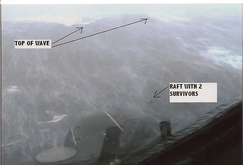
    FURTHER OUT TO SEA, CG1502 WAS CONDUCTING ITS SEARCH WHEN THEY SIGHTED A FLARE IN THE DISTANCE, BARELY VISIBLE ABOVE THE ENORMOUS WAVE TOPS. FLYING OVERHEAD, CG1502 LOCATED A RAFT, MARKED THE POSITION AND DROPPED FLARES TO HELP IDENTIFY THE LOCATION WHILE THEY ENTERED A HOLDING PATTERN. FIGHTING THE HURRICANE FORCE WINDS, AND FLYING AS LOW AS 200 FEET ABOVE THE TOWERING WAVES, CG1502 DETERMINED THERE WERE THREE PEOPLE IN THE RAFT. D5 COMMAND CENTER WAS NOTIFIED IMMEDIATELY, AND THE SECOND H-60 OF THE MORNING WAS LAUNCHED.

    RECALLED TO DUTY EARLY MONDAY MORNING, THE CREW OF CG6014 DEPARTED AIR STATION ELIZABETH CITY AT 0740L WITH THE REPORTED POSITION OF THREE PEOPLE IN A LIFE RAFT STRANDED AT SEA. THESE WERE THE SURVIVORS OF THE S/V SEAN SEAMOUR II. SOMETIME DURING THE NIGHT THE VESSEL HAD CAPSIZED AND TRAPPED THE THREE SAILORS INSIDE. WHEN THE VESSEL EVENTUALLY RIGHTED ITSELF THE THREE ABANDONED THE VESSEL TO THEIR LIFE RAFT AND ACTIVATED THEIR EMERGENCY BEACON WHILE THEY WITNESSED THE SEAN SEAMOUR II PLUNGE BENEATH THE WAVES.

    ARRIVING ON SCENE, CG6014 WAS VECTORED TO THE LOCATION OF THE LIFE RAFT BY CG1502. HAVING LOST ITS SEA ANCHOR UNDER THE STRAIN OF THE TUMULTUOUS SEAS, THE RAFT WAS NOW SKIMMING ACROSS THE WAVES. THE CREW OF CG6014 DECIDED ON DEPLOYING THE RESCUE SWIMMER TO RECOVER EACH MARINER ONE AT A TIME FROM THE RAFT. CG6014 DEMONSTRATED THE UTMOST IN CREW COORDINATION, TEAMWORK, AND AERONAUTICAL SKILL BY SUCCESSFULLY DEPLOYING THEIR RESCUE SWIMMER INTO THE PERILOUS SEAS THREE TIMES TO RECOVER THE SURVIVORS. AFTER THE THIRD SURVIVOR WAS HOISTED TO SAFETY, THE RESCUE SWIMMER, PHYSICALLY AND MENTALLY EXHAUSTED AND SUFFERING FROM SALT WATER INGESTION WAS RECOVERED. WITH THE RESCUE SWIMMER SAFELY ON BOARD, CG6014 DEPARTED FOR MARINE CORPS AIR STATION CHERRY POINT.

    WHILE THE CG6014 WAS RESCUING THE SURVIVORS OF THE SEAN SEAMOUR II, A SECOND C-130, CG1501 WAS LAUNCHED AT TO ASSIST WITH THE SEARCH FOR ANOTHER EMERGENCY SIGNAL EMINATING FROM THE S/V FLYING COLORS. DURING THE SEARCH CG1501 RECEIVED A CALL THAT THE 65FT S/V ILLUSION WAS IMPERILED 175NM SOUTHEAST OF ELIZABETH CITY. WHILE CG1501 DIVERTED TO ASSIST THE S/V ILLUSION, THE THIRD H-60 OF THE MORNING WAS LAUNCHED FROM AIR STATION ELIZABETH CITY. DEFTLY NEGOTIATING HEAVY RAINS, LOW CEILINGS AND VISIBILITY, AND ENCOUNTERING SEVERE TURBULENCE, CG6003 WAS VECTORED THROUGH THE MAELSTROM TO THE POSITION OF THE S/V ILLUSION WITH THE ASSISTANCE OF CG1501. ARRIVING ON SCENE, CG6003 FOUND THE S/V ILLUSION TRAVERSING THE WATER UNDER PARTIALLY UNFURLED SAILS. THE CREW OF CG6003 DECIDED TO RECOVER THE SURVIVORS ONE AT A TIME USING THE DIRECT DEPLOYMENT METHOD OF THE RESCUE SWIMMER. AS THE RESCUE SWIMMER APPROACHED THE FIRST SURVIVOR IN THE WATER, HE SAW THE LOOK OF DREAD IN HER EYES AND MADE A SPLIT SECOND DECISION TO DISCONNECT FROM THE HOIST AND ENTER THE PUNISHING SEAS WITH THE SURVIVOR IN ORDER TO CALM HER DOWN. RECOGNIZING THE CHANGE OF PLANS, THE CREW OF CG6003 SEAMLESSLY TRANSITIONED TO PERFORM A BASKET RECOVERY OF THE SURVIVOR. THE CREW OF CG6003 PERFORMED EACH HOIST FLAWLESSLY UNDER EXTREMELY DEMANDING CONDITIONS. WITH ALL THE SURVIVORS OF THE S/V ILLUSION SAFELY ABOARD AND THE RECOVERY OF THE RESCUE SWIMMER, CG6003 DEPARTED SCENE. UPON THE RETURN LEG TO ELIZABETH CITY, CG6003 EXPERIENCED A STRONG BURNING SMELL IN THE COCKPIT. IMMEDIATELY RECOGNIZING THE SOURCE, THE ENVIRONMENTAL CONTROL SYSTEM WAS SECURED PREVENTING AN ELECTRICAL FIRE AND FURTHER DAMAGE TO THE AIRCRAFT. CG6003 THEN MADE THE DECISION TO LAND AT THE CLOSEST AIRPORT IN BEAUFORT, NC.

    “IT SHOULD BE MENTIONED THAT AIR STATION ELIZABETH CITY SUPPORTED AROUND THE CLOCK FLIGHT OPERATIONS THAT EXTENDED THE FULL WEEK OF 07 MAY TO 11 MAY 2007 DURING ITS SEARCH FOR THE ILL FATED S/V FLYING COLORS. ALTHOUGH THE VESSEL IS BELIEVED TO HAVE BEEN LOST AT LOST SEA, THE MEN AND WOMEN OF THIS AIR STATION VALIANTLY DEMONSTRATED THEIR UNWAVERING DEDICATION AND DEVOTION TO DUTY IN THEIR EVER VIGILANT WATCH OVER THE GRAVE YARD OF THE ATLANTIC.”

    “FOR THE RESCUE OF THE THREE SURVIVORS ABOARD THE S/V SEAN SEAMOUR II THE CREWS OF CG 6014 AND CG 1502….”

    “RECEIVING THE AWARD OF THE AIR MEDAL – AVIATION SURVIVAL TECHNICIAN SECOND CLASS DREW D. DAZZO, H-60 RESCUE SWIMMER”

    “RECEIVING THE AWARD OF THE COAST GUARD COMMENDATION MEDAL, GOLD STAR IN LIEU OF A FOURTH – LIEUTENANT COMMANDER NEVADA A. SMITH, H-60 AIRCRAFT COMMANDER – THE OPERATIONAL DISTINGUISHING DEVICE IS AUTHORIZED”

    “RECEIVING THE AWARD OF THE COAST GUARD COMMENDATION MEDAL – LIEUTENANT JUNIOR GRADE AARON G. NELSON, H-60 COPILOT – THE OPERATIONAL DISTINGUISHING DEVICE IS AUTHORIZED”

    “RECEIVING THE AWARD OF THE COAST GUARD COMMENDATION MEDAL, GOLD STAR IN LIEU OF A SECOND – AVIATION MAINTENANCE TECHNICIAN SECOND CLASS SCOTT D. HIGGINS, H-60 FLIGHT MECHANIC – THE OPERATIONAL DISTINGUISHING DEVICE IS AUTHORIZED”

    “RECEIVING THE AWARD OF THE COAST GUARD COMMENDATION MEDAL – LIEUTENANT PAUL R. BEAVIS, C-130 AIRCRAFT COMMANDER – THE OPERATIONAL DISTINGUISHING DEVICE IS AUTHORIZED”

    “RECEIVING THE AWARD OF THE COAST GUARD COMMENDATION MEDAL – AVIONICS ELECTRICAL TECHNICIAN FIRST CLASS MARCUS C. JONES, C-130 NAVIGATOR – THE OPERATIONAL DISTINGUISHING DEVICE IS AUTHORIZED”

    “RECEIVING THE AWARD OF THE COAST GUARD ACHIEVEMENT MEDAL, GOLD STAR IN LIEU OF A SECOND – LIEUTENANT EDWARD C. AHLSTRAND, C-130 COPILOT – THE OPERATIONAL DISTINGUISHING DEVICE IS AUTHORIZED”

    “RECEIVING THE AWARD OF THE COAST GUARD ACHIEVEMENT MEDAL – AVIATION MAINTENANCE TECHNICIAN SECOND CLASS STACY A. SORENSON, C-130 FLIGHT ENGINEER – THE OPERATIONAL DISTINGUISHING DEVICE IS AUTHORIZED”

    “RECEIVING THE AWARD OF THE COAST GUARD ACHIEVEMENT MEDAL – AVIATION MAINTENANCE TECHNICIAN THIRD CLASS CASEY E. GREEN, C-130 DROPMASTER – THE OPERATIONAL DISTINGUISHING DEVICE IS AUTHORIZED”

    “RECEIVING THE AWARD OF THE COAST GUARD ACHIEVEMENT MEDAL – AVIONICS ELECTRICAL TECHNICIAN THIRD CLASS RYAN A. CANTU, C-130 AIR CREWMAN – THE OPERATIONAL DISTINGUISHING DEVICE IS AUTHORIZED”

    “AVIONICS ELECTRICAL TECHNICIAN SECOND CLASS JESSE W. BENNETT, C-130 RADIO OPERATOR, HAS BEEN HONORABLY DISCHARGED FROM THE COAST GUARD AND IS CURRENTLY SERVING IN THE COAST GUARD RESERVES AT ISC SEATTLE. HE IS RECEIVING THE AWARD OF THE COAST GUARD ACHIEVEMENT MEDAL – THE OPERATIONAL DISTINGUISHING DEVICE IS AUTHORIZED”

    “ALSO, THIS CREW OF CG1502 RECEIVED THE ELMER F. STONE AWARD, AWARDED TO THE COAST GUARD C-130 CREW SEARCH AND RESCUE CASE OF THE YEAR.”

    “FOR THE RESCUE OF THE THREE SURVIVORS ABOARD THE S/V SEEKER, THE CREW OF CG 6041….”

    “RECEIVING THE AWARD OF THE AIR MEDAL, GOLD STAR IN LIEU OF A SECOND – AVIATION SURVIVAL TECHNICIAN SECOND CLASS MICHAEL C. ACKERMANN, H-60 RESCUE SWIMMER

    “RECEIVING THE AWARD OF THE COAST GUARD COMMENDATION MEDAL, GOLD STAR IN LIEU OF A SIXTH – LIEUTENANT COMMANDER DANIEL J. MOLTHEN, H-60 AIRCRAFT COMMANDER – THE OPERATIONAL DISTINGUISHING DEVICE IS AUTHORIZED”

    RECEIVING THE AWARD OF THE COAST GUARD ACHIEVEMENT MEDAL – LIEUTENANT GREGORY A. CLAYTON, H-60 COPILOT – THE OPERATIONAL DISTINGUISHING DEVICE IS AUTHORIZED”

    “AVIATION MAINTENANCE TECHNICIAN SECOND CLASS DANIEL F. CANCETTY, H-60 FLIGHT MECHANIC, IS UNABLE TO BE HERE TODAY AND WILL BE RECEIVING THE AWARD OF THE COAST GUARD COMMENDATION MEDAL, GOLD STAR IN LIEU OF A SECOND – THE OPERATIONAL DISTINGUISHING DEVICE IS AUTHORIZED”

    “FOR THE RESCUE OF THE THREE SURVIVORS ABOARD THE S/V ILLUSION THE CREW OF CG 6003….”

    “RECEIVING THE AWARD OF THE AIR MEDAL – AVIATION SURVIVAL TECHNICIAN SECOND CLASS STEVEN M. FISCHER, RESCUE SWIMMER”

    “RECEIVING THE AWARD OF THE COAST GUARD COMMENDATION MEDAL, GOLD STAR IN LIEU OF A THIRD – LIEUTENANT SCOTT E. WALDEN, H-60 AIRCRAFT COMMANDER – THE OPERATIONAL DISTINGUISHING DEVICE IS AUTHORIZED”

    “RECEIVING THE AWARD OF THE COAST GUARD COMMENDATION MEDAL – LIEUTENANT JUNIOR GRADE WILLIAM F. COTY III, H-60 COPILOT – THE OPERATIONAL DISTINGUISHING DEVICE IS AUTHORIZED”

    “RECEIVING THE AWARD OF THE COAST GUARD COMMENDATION MEDAL – AVIATION MAINTENANCE TECHNICIAN THIRD CLASS JUSTIN J. CIMBAK, H-60 FLIGHT MECHANIC – THE OPERATIONAL DISTINGUISHING DEVICE IS AUTHORIZED”

    “LADIES AND GENTLEMEN, THE HEROES OF COAST GUARD AIR STATION ELIZABETH CITY.”

    PAUSE FOR APPLAUSE

    RADM Rosa: Presents awardees with citation, poses for pictures, and pins on medal. (With the summary of action being read only once, RADM Rosa may want to pin on award first, then present citation, pause for a photo with member and opened citation, then final hand shake and depart stage.)

    XO: Invite RADM Rosa to give remarks and present unit award. “NOW I WOULD LIKE TO INVITE RADM ROSA TO GIVE THE KEY NOTE ADDRESS.” (OR invite RADM Rosa to podium for remarks (opportune to time to summarize unit events from Aug 05 to May 07 and present Unit Award to Acting CO and CMC/LCPO, then Acting CO can give closing remarks)

    CDR GORMAN: Be prepared to read Unit Citation.

    CDR Lyons: Prior to the reading of Unit Citation. Reposition in front of troops, about face and order: “STATION, ATTENTION”, and about face.


THE CITATION

The Commandant of the Coast Guard takes pleasure in presenting the COAST GUARD UNIT COMMENDATION to:

COAST GUARD AIR STATION ELIZABETH CITY

ELIZABETH CITY, NORTH CAROLINA

for service as set forth in the following

CITATION:

"For exceptionally meritorious service from 29 August 2005 to 7 May 2007 while engaged in a broad spectrum of missions, extending the Air Station's resources far beyond the scope of normal operations. During this time, aircrews flew 10,398 flight hours, over 976 hours above programmed levels. The Air Station provided inspirational, often heroic, search and rescue (SAR) response on 408 occasions, resulting in 277 lives saved, including seven long-range, extremely arduous SAR missions to Bermuda, hazardous flood relief efforts in Pennsylvania, and a five aircraft maximum effort that saved 12 mariners from four stranded vessels ravaged by sub-tropical storm Andrea. Additionally, Air Station Elizabeth City flawlessly executed massive air support operations following Hurricanes KATRINA and RITA, conducting life-saving SAR and transporting over one million pounds of relief supplies to the devastated Gulf Coast region. Air Station Elizabeth City also supported critical law enforcement and security missions in the national capital region preventing terrorist attacks, and from Central America to Canada, resulting in the seizure of 3,713 pounds of cocaine with an estimated street value of $25 million, while maintaining an impressive 73 percent average aircraft availability rate. Despite this incredible operational tempo, the Air Station's nascent Maritime Security and Response Team forward deployed in support of a number of major counter terrorism exercises, including Frontier Sentinel '06. Elizabeth City's C130 and H60 Prime Units spearheaded the implementation of countless noteworthy projects that have had far-reaching impacts on the entire Coast Guard aviation community. Unit personnel positively enhanced the Coast Guard's image globally by providing hours of support as the Air Station and personnel were showcased in the major motion picture "The Guardian." The dedication, pride, and professionalism displayed by Air Station Elizabeth City personnel, reflect credit upon themselves, their unit and the United States Coast Guard."

The Operational Distinguishing device is authorized.

For the Commandant,


D. B. PETERMAN

Vice Admiral, U.S. Coast Guard


Commander, Atlantic Area

CONCLUSION


XO thanks guests
:


    CDR GORMAN: CHAPLAIN TANIS WILL NOW GIVE THE BENEDICTION. WILL EVERYONE PLEASE RISE AND REMAIN STANDING FOR THE DEPARTURE OF THE OFFICIAL PARTY.”

    CHAPLAIN: Proceed to lectern. When all people are standing, deliver benediction. “LET US PRAY. . . . . .AMEN”

    XO oders CDR Lyons: “OPERATIONS OFFICER, PREPARE THE STATION FOR DISMISSAL.”

    CDR GORMAN: NOW, DISTRICT FIVE DEPARTING…..NOW, AIR STATION ELIZABETH CITY ACTING DEPARTING.”

    CDR Lyons: About face and order: SECTION OFFICERS, HAND SALUTE,” Execute about face and hand salute.

    CDR Lyons: After RADM Rosa has exited the honors area, order, “READY TO.”

    CDR GORMAN: LADIES AND GENTLEMEN, THIS CONCLUDES TODAY’S CEREMONY, PLEASE HAVE A GOOD AFTERNOON.”

    CDR Lyons: After official party departs, execute about face and order: SECTION OFFICERS, DISMISS YOUR SECTIONS.” Return hand salute.

    Section Officers: On command, execute salute, about face, and dismiss your sections and advise them they are invited to the reception.

    MUSIC MONITOR: (AET3 Meseke) After RADM Rosa has exited the honors area, play “Stars and Stripes Forever” as the formation breaks up.

    (PROGRAM # 21)

  1. Approximate time of ceremony completion.

1101 Van arrives outside hangar 55 training room.

1115 Lunch at the galley.


From US Senator Bryon Dorgan

NORTH DAKOTA NATIVE HONORED FOR BRAVERY

For Immediate Release CONTACT: Barry Piatt

Wednesday or Brenden Timpe

December 19, 2007 PHONE: 202-224-2551

Williston native receives heroism medal from Coast Guard:

NORTH DAKOTA NATIVE HONORED FOR BRAVERY

(WASHINGTON, D.C.) --- U.S. Senator Byron Dorgan (D-ND) applauded a Williston native for his work of heroism and skill as a member of the Coast Guard, to save the lives of foundering sailors during a tropical storm.

Lieutenant Junior Grade Aaron Nelson was awarded the Coast Guard Commendation Medal Wednesday for actions and aeronautical skills "essential in saving three lives" the Coast Guard said. Serving as the co-pilot on the MH-60 helicopter on May 7, 2007, Nelson and the rest of the crew are credited with scooping from the ocean three sailors who had to abandon their ship during sub-tropical storm Andrea.

Lieutenant Nelson grew up in Williston and graduated from Williston High School.

Based at Air Station Elizabeth City in Elizabeth, North Carolina, the crew rescued the sailors during seas that climbed to 50 feet and winds that reached 70 knots. Lieutenant Nelson maintained a steady hover 100ft over the ocean in the trying conditions while skillfully lowering the rescue swimmer into the water to recover the sailors. It was necessary for Lieutenant Nelson to repeat this feat twice more so the sailors could be saved and the rescue swimmer could be recovered safely.

The medal was presented by Rear Admiral Fred Rosa, Commander of the Coast Guard Fifth District today at the Coast Guard Air Station in Elizabeth City, NC.

"Aaron Nelson is a true credit to North Dakota and the Coast Guard. His actions saved the lives of three people who are undoubtedly grateful, but so are the rest of us to know that we have such a dedicated person serving our nation," Dorgan said. "I'm so proud to say that Lieutenant Nelson has been recognized for his heroism. He makes North Dakota proud."

-- END –


ONCE AGAIN OUTSTANDING JOB AND CONGRATULATIONS TO ALL!

RS


Robin Storm previous s/v Sean Seamour II posts:

Summary of Action for CG6014 for the S/V SEAN SEAMOUR II- REDUX - Plus
WebExclusive EPIRBs and the s/v Sean Seamour II - Part III

WebExclusive EPIRBs and the s/v Sean Seamour II - Part II
EPIRBs and the s/v Sean Seamour II
NHC Report on Subtropical Storm Andrea
Cheating Death On The High Seas
The s/v Sean Seamour II & The Hatteras Trench
High Sea's Update On Sean Seamour II
The Story of the Sailing Vessel Sean Seamour II

gCaptain previous s/v Sean Seamour II posts:
gCaptain Exclusive - Sailing in Severe Weather
Lessons Learned

Tuesday, December 18, 2007

Indiana sets up standard for warning of dangers

Monday, December 17, 2007
Indiana sets up standard for warning of dangers Hodgepodge hurt communications

Associated Press

INDIANAPOLIS -- The state has created a standardized system to report severe weather and other hazardous conditions, replacing a hodgepodge of standards that varied from county to county.

All counties should begin using the new system immediately, said John Erickson, spokesman for the Indiana Department of Homeland Security, one of several agencies involved in devising the arrangement.

Officials saw the need for a uniform system after a blizzard last February.

"There were obviously issues with communication and consistency," he said. "It's very important everybody is on the same page."

Standards in many of the state's 92 counties were different, making it difficult for emergency personnel, the public and the news media to understand conditions throughout the state and, in some cases, between neighboring counties, said Greg Dhaene, director of the department's Response and Recovery Division.

The new system uses four levels for reporting conditions, ranging from caution to a declared emergency, which could limit travel to emergency personnel.

A statewide map showing different counties and their color-coded emergency levels will be posted online to allow people to see potential danger before traveling.

Even with the new system, the county emergency management director is in charge of determining which level of emergency is appropriate. The county commissioners then have the power to determine what types of restrictions are in place under each level of emergency.

Also involved in creating the system were members of the Emergency Management Alliance of Indiana Board, numerous county emergency management directors and the Indianapolis office of the National Weather Service.

See INDHS Press Release (PDF) December 14, 2007...State Unveils New Standardized Hazards Reporting System

Christmas Tornadoes?

Tornadoes Touch Down


(Image 3 of 3)
Last Update:12/17/2007 6:51:25 PM
Web Editor: Rich Hardwick


By: Grant Gilmore


The severe weather over the weekend left a path of destruction with at least eight confirmed tornadoes across the Southeast.

Here in Central Georgia, preliminary reports reveal that at least four tornadoes touched down with one tornado reaching EF2 strength with wind speeds in excess of 111 mph.

A warm moist airmass at the surface combined with strong upper level support to produce the outbreak of severe weather and tornadoes across the area Saturday night.

Tracking through our southeastern counties damage was left in the storms wake from Wilcox, to Treutlen county.

After a day of periodic showers across the region at 9:30 p.m. an EF1 Tornado touched down briefly just west of Owensboro in Wilcox County.

After ripping the roof off of an old dairy shed and destroying a cinder block building attached to the shed the tornado the tornado lifted back up off the ground.

However, damaging winds of 70 to 100 mph continued to cause damage across the southeast of the county.

Around 9:50 p.m. just southeast of Abbeville damaging winds near 70 mph ripped the roof off a house and blew a truck off the road and into a ditch.

The system then moved into Telfair and Dodge Counties where in Telfair numerous trees and power lines were downed as winds raced across the area near 80 mph.

Dodge County, however, saw an EF0 tornado touch down about 6 miles north of Helena near the intersection of Long Bridge Road and Bethel Church Road.

In the half mile long and 25 yard wide damage path a manufactured home was damaged along with numerous downed trees and power lines.

The complex of storms then continued to race towards the northeast at around 55 mph into Treutlen where at 10:41 p.m. an EF1 tornado touched down about a mile southeast of Lothair.

Causing mainly tree damage, the tornado moved to the northeast when by 10:42 strengthened into EF2 strength over the city of Lothair where it destroyed a fire department building on State Road 199.

Shortly after, the tornado weakened to EF1 strength while destroying a manufactured home and pushing another off of its foundation.

Moments later a weaker EF0 tornado touched down tearing a carport section off of a house and then threw it about 50 yards across the street.

Across Central Georgia there were no fatalities reported as a result of the severe weather, however, just south of our area in Turner County there was one fatality.

A semi-truck driving north on I-75 near mile marker 83 was tossed off the interstate by an EF1 tornado and thrown into an embankment.

Though the storm brought much destruction across areas of southeastern Central Georgia a lot of much needed rain also came as a result of the storm. More than three inches of rain fell in some places in Central Georgia which took the yearly deficit from over 9 inches to just over 7 inches at the Middle Georgia Regional Airport.

RS

Monday, December 17, 2007

The Madden-Julian oscillation

The Madden-Julian oscillation

B. Geerts and M Wheeler 5/98

Discovery

In the tropics weather is not as predictable as in mid-latitudes. That is because in mid-latitudes the weather variables (clouds, precipitation, wind, temperature, and pressure) are largely governed by the upper-tropospheric Rossby waves, which interact with surface weather in a process called baroclinic instability (Note 13.B).

In the tropics there is no such dominant instability or wave motion, and therefore the weather is less predictable for the 1-10 day period. Until recently it was believed that tropical weather variations on time scales less than a year were essentially random.

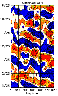
The MJO, also referred to as the 30-60 day or 40-50 day oscillation, turns out to be the main intra-annual fluctuation that explains weather variations in the tropics. The MJO affects the entire tropical troposphere but is most evident in the Indian and western Pacific Oceans. The MJO involves variations in wind, sea surface temperature (SST), cloudiness, and rainfall. Because most tropical rainfall is convective, and convective cloud tops are very cold (emitting little longwave radiation), the MJO is most obvious in the variation of outgoing longwave radiation (OLR), as measured by an infrared sensor on a satellite.

Figure 1 (from Elleman 1997) shows how the OLR anomalies in the eastern hemisphere propagate to the east at around 5 m/s. The OLR signal in the western hemisphere is weaker, and the recurrence interval for the eastward propagating OLR anomalies in the eastern hemisphere is about 30 to 60 days. How exactly the anomaly propagates from the dateline to Africa (i.e. through the western hemisphere) is not well understood. It appears that near the dateline a weak Kelvin wave propagates eastward and poleward at a speed exceeding 10 m/s.

Associated with the propagation of convective anomalies, the MJO involves variations in the global circulation. The MJO affects the intensity and break periods of the Asian and Australian monsoons and interacts with El Niño. Wet spells in the Australian monsoon occur about 40 days apart. Fairly weak correlations with the midlatitude rainfall patterns and jet stream characteristics have also been found (2).

In 1971 Roland Madden and Paul Julian (1) stumbled upon a 40-50 day oscillation when analysing zonal wind anomalies in the tropical Pacific. They used ten years of pressure records at Canton (at 2.8� S in the Pacific) and upper level winds at Singapore. The oscillation of surface and upper-level winds was remarkably clear in Singapore. Until the early 1980's little attention was paid to this oscillation, which became known as the Madden and Julian Oscillationnumber of MJO-related publications grew rapidly. (MJO), and some scientists questioned its global significance. Continuing reading

Speaking of surface weather and wave motion....


Nor'easter and Ice!

Brian A. Morganti of Storm Effects.com has some awesome shots from the snow storm that hit the Midwest including Chicago and merged with former Tropical Storm Olga now moving up the East Coast as a "Nor'easter" throwing a mixed bag including an ice storm in Berks County PA. (Click the Pix)


And

Steve Marshall is reporting that the same ice storm has fallen the WNEP tower in NE PA, which knocked out programming for a while.



Lastly

Bill Hark tells us that Storm Chaser Jim Reed will be on ABC Good Morning America on December 18 with Sam Champion, plugging his new book ...

by Jim Reed

Storm Chaser: A Photographer's Journey Cover


RS

Sunday, December 16, 2007

Sunday Morning Pretty!

http://static.flickr.com/119/311278983_ce3c8e6045.jpg

Well snow it did! Below are some of the totals from NWS Chicago.

The City came out of it pretty well with snow totals ranging between 4-6". South of the city? Oh well it is winter in Chicago ya' know! While this storm was bigger than the December 3rd-4th storm and we now have about 9" in total from both storms on the ground.

The streets are sloppy right now and of course not enough plows on the streets early enough but we escaped a major strike. Now its time for digging out and getting to the side streets. But this system is not done. Its next target? The North East!

Oh yeah... temps for tonight? Can you say 6 degrees?

000
NOUS43 KLOT 161617
PNSLOT

PUBLIC INFORMATION STATEMENT
NATIONAL WEATHER SERVICE CHICAGO
/ROMEOVILLE IL
800 AM CST SUN DEC 16 2007

SNOWFALL AND SNOW DEPTH REPORTS.
DATA PROVIDED BY NATIONAL WEATHER SERVICE CHICAGO AREA AND ROCKFORD
AREA SNOWFALL TEAM.

12 HR SNOWFALL 12 HR SNOWFALL TOTAL
LOCATION ENDING 6AM ENDING 6PM SNOW
TODAY YESTERDAY DEPTH AT 6AM
ILLINOIS

BATAVIA 3.0 / 1.2 / 4
BEACH PARK 2.8 / 3.0 / 8
BEECHER 6.6 / 1.5 / 8
CALUMET CITY 8.3 / 2.2 / 10
CHICAGO-NW SIDE / 1.1 /
CICERO / 0.8 /
DIXON-EAST SIDE 1.2 / 2.8 / 7
FRANKFORT 8.2 / 1.3 / 8
GRAYSLAKE 3.8 / 2.9 / 11
LA GRANGE 5.5 / 1.4 / 7
MOUNT MORRIS / 4.5 /
NAPERVILLE 2.6 / 1.2 / 6
NEW LENOX / 1.2 /
OAK LAWN / 2.3 /
OAK BROOK 2.4 / 0.9 / 5
PLAINFIELD 4SW 2.2 / 1.2 / 4
PLAINFIELD 1.8 / 1.2 / 4
RICHTON PARK 9.6 / / 10
SCHAUMBURG 3.3 / 1.2 / 6
SOUTH BELOIT 3SE / 2.1 /
WILLOWBROOK 3.8 / 1.7 / 6

NORTHWEST INDIANA

HIGHLAND 11.0 / / 11
SCHERERVILLE 8.2 / 1.1 / 8
VALPARAISO 3SE 6.0 / 1.4 / 7
WHITING 3.0 / 3.0 / 3

$$


SNOW Chicago Update

This is an amazing storm system. Currently in Chicago we have approximately 3 to 6 " of snow. Winds are at 18 gusting to 22mph. Between Lincoln park and downtown we had near blizzard conditions.

Note the impressive snow bands on the radar at left. The darker green are more narrow but also more intensive snow bands.

These are so narrow that as of 00:15 this morning. O'Hare International Airport was reporting 2" of snow and Midway was reporting 6" of snow. Currently according to spotter reports snow totals for the Chicagoland area range between 3" to 6" with snow falling steadily and expected to continue until at least 0600.


Snow fall amounts are expected to range from 5-7" in the city, 5-9” northwest of the city to a foot or more in northwest Indiana.

This system is expect to merge with former Tropical Storm Olga and turn into a Nor'easter dumping a potential mixed bag on New England.

Pretty Chicago evening though! If you don't have to work in it...or drive in it!


Camera Animation Last Hour | Today | 30 days*
* Broadband recommended

Stay dry and stay safe!
RS

Saturday, December 15, 2007

Weather Update for Chicagoland

Just got this report in from Gilbert Sebenste, Staff Meteorologist, Northern Illinois University, and I spoke to NWS Chicago just a short while ago. Heavy Snow Warning in effect for Cook, DuPage, Grundy, Will, LaSalle and Kankakee counties in Illinois.

"The low pressure system now over southern Tennessee is moving northeastmore slowly than expected.

That is because it is intensifying more quickly and becoming stronger than models and data suggested it would, even through early this afternoon.

The National Weather Service has just upgraded the snow advisory to a heavy snow warning along and southeast of a line from Evanston to West Chicago to LaSalle, for 6" and locally heavier amounts, including Cook, DuPage, Grundy, Will, LaSalle and Kankakee counties until noon tomorrow. Everyone north and west of there is under a snow advisory for 3"-6" of snow through tomorrow morning. Because the storm is moving more slowly, it has become more than obvious that the snow will last later, and should continue until it tapers to flurries Sunday morning.

Final snow accumulations are expected to range from around 6" at Hoffman Estates, to 6"-8" at Naperville, to 4"-6" at DeKalb, and 2"-5" at our far western/northwestern campuses. However, latest radar trends are making me uncomfortable...and it is entirely possible DeKalb could see 6" or more storm total snowfall by morning.

Fiurthermore...because of the more northwest track of the storm, we will see stronger winds on Sunday. In fact, I now believe we'll see wind gusts as high as 30 MPH in the morning, and 25 MPH in the afternoon from the northwest. Because the snow is rather powdery, blowing and drifting snow will be a concern, mostly in open and rural areas.

Sorry, folks...this system intensified considerably more than expected, which slowed it down and is also forcing it to track much closer to us than anticipated even last night.

As of 4 PM...3.0" has come down with this system so far in DeKalb since it started early this morning."

From NWS CHICAGO

023
WWUS43 KLOT 152148
WSWLOT

URGENT - WINTER WEATHER MESSAGE
NATIONAL WEATHER SERVICE CHICAGO/ROMEOVILLE IL
348 PM CST SAT DEC 15 2007

...WINTER STORM CONTINUES TO DEVELOP OVER THE LOWER MISSISSIPPI
VALLEY...

.LOW PRESSURE ACROSS WESTERN TENNESSEE WILL CONTINUE TO STRENGTHEN
TONIGHT AS IT LIFTS NORTHEAST INTO THE OHIO VALLEY...REACHING
NORTHWEST OHIO BY SUNDAY MORNING. A STRONG UPPER LEVEL DISTURBANCE
IS SUPPORTING THIS DEVELOPMENT AND WILL SPREAD A BAND OF HEAVY
SNOW NORTHWEST OF THE STORM TRACK...ACROSS PARTS OF CENTRAL AND
NORTHERN ILLINOIS...AND INTO NORTHERN INDIANA. LIGHT SNOW WHICH
HAS OVERSPREAD PARTS OF NORTHERN ILLINOIS AND INDIANA TODAY WILL
GRADUALLY INTENSIFY THROUGH THE EVENING HOURS AND WILL CONTINUE
THROUGH THE OVERNIGHT HOURS AS THE LOW PRESSURE SYSTEM BEGINS TO
RAPIDLY DEEPEN. SNOW WILL GRADUALLY TAPER TO LIGHT SNOW AND
FLURRIES EARLY SUNDAY MORNING. TOTAL SNOW ACCUMULATIONS IN EXCESS
OF 6 INCHES ARE POSSIBLE MAINLY SOUTHEAST OF A LINE FROM EVANSTON
TO WEST CHICAGO TO MENDOTA.

ILZ013-014-019>022-160600-
/O.UPG.KLOT.SN.Y.0009.000000T0
000Z-071216T1800Z/
/O.EXA.KLOT.HS.W.0001.000000T0000Z-071216T1800Z/
DUPAGE-COOK-LA SALLE-KENDALL-GRUNDY-WILL-
INCLUDING THE CITIES OF...CHICAGO...OTTAWA...OSWEGO...MORRIS...
JOLIET
348 PM CST SAT DEC 15 2007

...HEAVY SNOW WARNING IN EFFECT UNTIL 12 PM CST SUNDAY...

THE NATIONAL WEATHER SERVICE IN CHICAGO HAS ISSUED A HEAVY SNOW
WARNING...WHICH IS IN EFFECT UNTIL 12 PM CST SUNDAY. THE SNOW
ADVISORY IS NO LONGER IN EFFECT.

LIGHT TO MODERATE SNOW WILL GRADUALLY INTENSIFY THROUGH THE
EVENING HOURS...WITH MODERATE TO HEAVY SNOW CONTINUING THROUGH THE
OVERNIGHT HOURS. STORM TOTAL SNOW ACCUMULATION IS EXPECTED TO
RANGE FROM UP TO 6 INCHES ACROSS THE EVANSTON...WEST
CHICAGO...AND MENDOTA AREAS...TO 6 TO 9 INCHES FROM CHICAGO AND
THE SOUTHERN SUBURBS TO JOLIET TO MORRIS. THE INCREASING INTENSITY
OF THE SNOW LATE THIS AFTERNOON INTO TONIGHT WILL MAKE FOR
HAZARDOUS TRAVEL ACROSS THE AREA THIS EVENING INTO THE OVERNIGHT
HOURS AS MANY ROADS BECOME SNOW PACKED. IN ADDITION TO THE HEAVY
SNOW ACCUMULATION...NORTH WINDS WILL STRENGTHEN THROUGH THE
EVENING WITH GUSTS TO 30 MPH POSSIBLE OVERNIGHT. THIS WILL RESULT
IN AREAS OF BLOWING SNOW AND REDUCED VISIBILITIES. SNOW WILL TAPER
TO LIGHT SNOW AND FLURRIES ON SUNDAY MORNING.

A HEAVY SNOW WARNING MEANS SEVERE WINTER WEATHER CONDITIONS ARE
EXPECTED OR OCCURRING. SIGNIFICANT AMOUNTS OF SNOW ARE FORECAST
THAT WILL MAKE TRAVEL DANGEROUS. ONLY TRAVEL IN AN EMERGENCY. IF
YOU MUST TRAVEL...KEEP AN EXTRA FLASHLIGHT...FOOD...AND WATER IN
YOUR VEHICLE IN CASE OF AN EMERGENCY.

RS

EEs explain rogue waves

WoW! I have been away from blogging for just a little over three weeks and it feels more like three months.

Its been a busy time both in business and personally for me. I will have some more news about both very shortly.

But in the meantime there is weather and marine news out there.

Yes winter has arrived! Just ask anyone still without power in the mid west right now or living in Boston. Today NWS Chicago is reporting 3 to 5" of snow with lake effect. The heaviest will be during the overnight hours into Sunday. Though the temps and winds so far have not been as nasty as they can get and I am sure that is coming soon.

Talking about nasty. Here is a video of the impact of falling ice during last weeks ice storm in the mid west. Lesson Learned here? Look up when parking your car after you have been warned! This was shot by Storm Chaser and WX-Chase Moderator Chris Novy!


Killer Ice - Watch more free videos


Our featured article of today..


EEs explain rogue waves
By EE Times

R. Colin Johnson
(12/14/2007 2:28 PM EST)
URL: http://www.eetimes.com/showArticle.jhtml?articleID=204803618


Rogue waves as high as a 10-story building have been offered as an explanation for the disappearance of ships as big as an ocean liner, despite the lack of survivors to tell the tale. Recently, remote sensors set up in the oceans of the world have confirmed that single rogue waves as tall as 100 feet occur more frequently than Gaussian statistics can explain. For the first time EEs have generated rogue waves in optical fibers and have confirmed the mechanism that generates them, which they say can occur in other media too, including the ocean.

"Rogue waves are an apparently random phenomenon that is seeded by noise," said lead investigator on the project Daniel Solli, a researcher at the University of California at Los Angeles (UCLA) Henry Samueli School of Engineering and Applied Science. "We have shown that noise with the correct properties can foster the generation of one of these rogue waves."

According to Solli and Bahram Jalali, a UCLA professor of electrical engineering and the research group leader, rogue waves are analogous to the butterfly effect, a phenomenon in which, under the right initial conditions, a butterfly flapping its wings can cause a hurricane. Of course, these initial conditions are exceedingly rare, but the bottom line for the butterfly effect, according to Solli and Jalali, is that weather is very sensitive to initial conditions, as is the generation of rogue waves.

"Like the weather, these rogue waves appear to be extremely sensitive to initial conditions," said Solli. "It is still a deterministic system, but one that is very difficult to predict, because a very, very minute change in initial conditions can have a dramatic impact on the result."

Researchers studying a microstructured optical fiber near the threshold of soliton-based supercontinuum generation observed the generation of rogue waves in the optical fiber, and they began modeling the mechanism. As a result, the researchers have now characterized the proper initial conditions for generating rogue waves in any medium.

"We show that a particular set of initial conditions are responsible for generating rogue waves," said Solli. "In our experiment we discovered that we were getting some rare events that were far larger than any of the neighboring pulses, and that led us to explore this connection between this phenomenon and the oceanic phenomenon which has a very similar kind of effect."

According to the researchers, rogue waves follow "L-shaped" statistics, as opposed to the more common Gaussian statistics. This accounts for the seemingly out-of-bounds size of rogue waves: in L-shaped distributions the heights of most waves are tightly clustered together, but large outliers also occur. Now Jalali's team is working on a more detailed model for the U.S. Department of Defense, which is aiming to harness the effect for military applications.

"The next step is learning how to engineer this phenomenon, because there must be some useful applications out there, if only we could predictably engineer the outcome of this event, which occurs very rarely now," said Jalali.

Other member of Jalali's team include UCLA engineering researchers Claus Ropers and Prakash Koonath. Funding is being provided by the U.S. Department of Defense and the Defense Advanced Research Projects Agency (DARPA)

Tropical Storm Olga

Seems like Tropical Storm Olga has made her stake in weather history as reported by Arthur Rabjohn CEM, Director Steelhenge Consulting Ltd.
www.steelhenge.co.uk

CARIBBEAN: Caribbean storm death toll rises

People were swept away in Santiago when flood waters were released The toll in the Caribbean from Tropical Storm Olga, a rare December cyclone, has risen to at least 38 confirmed deaths, officials say. Hardest hit was the Dominican Republic, where at least 35 people have been killed by floods and landslides. The death toll rose again on Friday after the bodies of 12 immigrants from neighbouring Haiti were discovered in Castanuelas, a town near the border. The UN has urgently appealed for $4m (£2m) to help the many left homeless.

National Hurricane Center Reports

NHC releases 2007 seasonal summaryNOAA also releases seasonal report


On the maritime front..

The main feature story of this blog has been the rescue of the s/v Sean Seamour II, that I have focused on is about to make news again. The USCG helicopter crew that rescued the three sailors from their potential watery graves during subtropical storm Andrea this past May are about to get decorated for heroism on December 19 at USCG Air Station Elizabeth City. I will have more as soon as the new medals are placed on their salad bars.


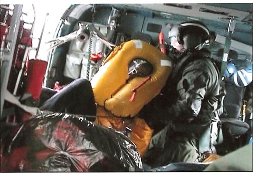
Swimmer Drew Dazzo in the helicopter resting before being evacuated with us to Cherry Point Military hospital for injuries sustained during our rescue, AC Lt. Comdr. Nevada Smith supervising the transfer while coordinating with operations.


KAB 101

Here is a shot many of you may not have seen of the KAB 101 incident
that we reported about back on October 29th and 30th. when reported large waves struck Mexico state-owned drilling platform Usumacinta which slammed into the Kab 101 Light-Production Rig on Oct. 24, killing 21 people.


On the weather lighter side....

If global warming, greenhouse effects, jet stream changes or just plain lousy winter weather or any lousy weather for that matter does not confuse you enough? Let's just add good ole Pat Robinson to the equation. The bad weather we are having is because?


RS